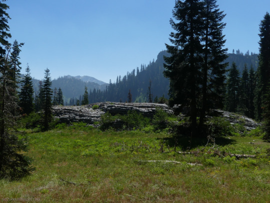
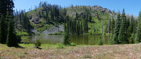
#Siskiyou National Forest
Photo

Creek Bottom - Oregon
Harry Snowden
#photographers on tumblr#oregon#pnw#Siskiyou National Forest#hiking#camping#exploreoregon#rapids#water#sucker creek#wilderness#nature photography
4K notes
·
View notes
Text
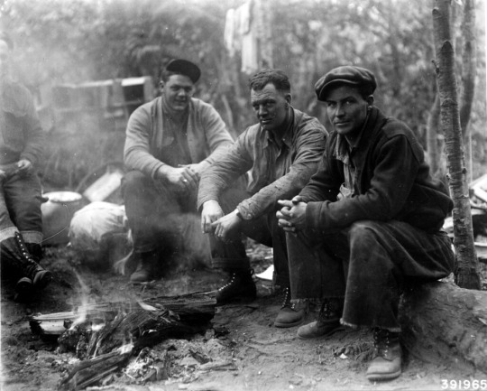
A group of Civilian Conservation Corps relax after a hard day of fighting fires on Poverty Ridge.
Siskiyou National Forest
1936
#vintage camping#campfire light#siskiyou national forest#camping#fire fighting#history#CCC#hiking#outdoors
143 notes
·
View notes
Text
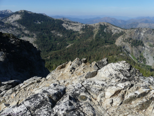


Russian Wilderness, Klamath National Forest, California
Day 2: Tagging the top of Etna Mountain and then stopping by Meeks Meadow Lake and Smith Lake (by trail that isn't) and finally Paynes Lake.
#hiking#nature#landscape#travel#hike#outside#California#peak bagging#mountains#Siskiyou County#Russian Wilderness#Klamath National Forest#KlamathNF#newt#wildlife#lakes#Paynes Lake#Ruffey Lakes#Meeks Meadow Lake#Smith Lake#PNW#PCT
4 notes
·
View notes
Text


Auriscalpium vulgare, on a Douglas Fir cone. Didn't think I'd luck out on seeing this neat mushroom, it blends in with all the other duff mushrooms on the forest floor. About 1" tall. Was only able to identify this single individual in the area. Found on a tall, shaded ridge along the edge of an old grove of Douglas Fir.
the first two are 80 image focus stacks
Rogue-Siskiyou National Forest, Oregon
#auriscalpium vulgare#tooth fungi#fungi#mushrooms#mycology#forest floor#macrophotography#mushroom photography#nature photography#naturecore#nikon#focus stacking#105mm#original photographers#public lands
45 notes
·
View notes
Text
youtube
OREGONS LARGEST FIRE 2002 - BUSCUIT 500,000acres 781sq/m
PDX IS 145sq miles 92,000acres
Long Draw Fire burned more than 550,000 acres in Southeast Oregon in 2012
The Long Draw Fire was a wildfire started by a lightning strike on July 8, 2012 that burned 557,648 acres (2,257 km2) acres in southeastern Oregon, in the Western United States.[1][2] It was Oregon's largest wildfire since the 1865 Silverton Fire which burned over 1 million acres.[3]
Biscuit Fire burned more than 500,000 acres in Southern Oregon in 2002
The Biscuit Fire was a massive wildfire in 2002 that burned nearly 500,000 acres in the Rogue River–Siskiyou National Forest, in southern Oregon and northern California, in the Western United States. The fire was named after Biscuit Creek in southern Oregon. Wikipedia
Start date: 2002
Cause: Lightning
Cost: Millions of dollars

Bootleg Fire has burned 400,389 acres in Southern Oregon this year
The Bootleg Fire, named after the nearby Bootleg Spring, was a large wildfire that started near Beatty, Oregon, on July 6, 2021. Before being fully contained on August 15, 2021, it had burned 413,765 acres. It is the third-largest fire in the history of Oregon since 1900. Wikipedia
Location: Beatty
Dates: Jul 6, 2021 – Aug 15, 2021
Buildings destroyed: 408
Burned area: 413,765 acres; 647 square miles; 1,674 square kilometres; 167,445 hectares
Cause: Lightning


Buzzard Complex Fire burned 395,747 acres in Eastern Oregon in 2014
Buzzard Complex
Estimated acreage:
395,747
Containment:
85 percent
Cause and date started
: Lightning, July 14
Current resources:
20 20-person fire crews, five helicopters, 41 engines, total workers 960
Effect:
Kay Teisl, executive director of the
2 notes
·
View notes
Text
Bigfoots Don’t Fear to Tread
Bluff Creek, a cliff-lined mountain stream that flows through the Six Rivers National Forest in the wild north of the state, is the center of Bigfoot country. By now, most Americans have heard of Bigfoot, the North American Abominable Snowman, usually from sleazy weekly tabloids or dubious TV documentaries. Still, a brief recap of the stories and legends is in order:
Bigfoot-a.k.a. Sasquatch, Skunk Ape, and so forth-is a wild, hairy, apelike creature who’s been sighted sporadically in the forests and mountains of North America ever since Indian times. He’s between seven and eleven feet tall, judging by the deeply imprinted giant tracks that gave him his most famous moniker, weighs several hundred pounds. Bigfoot is often accompanied by an evil odor that resembles the stench of garbage or rotten eggs. Both male and female varieties of Bigfoot have been reported, and in 1924 a Canadian miner named Albert Ostman claimed to have been kidnapped for a week by a Bigfoot family.
Nobody quite agrees on just what the hairy beasts are. Some researchers think Bigfoot is a primitive hominid species that retreated into North America’s forests and swamps when modern men began occupying the continent many thousands of years ago. Others believe it’s a surviving relative of Gigantopithecus, an extinct giant ape. A third faction suspects that Bigfoot is a miragelike phantom formed by unknown geophysical forces. And of course, there are skeptics and debunkers, who write off the whole phenomenon as a product of overactive imaginations and yellow journalism.
Indian tribes are usually the most reliable authorities on bigfoot. Traditionally, they tend to regard the beasts as evil and avoid them. The creatures, in turn, generally avoid us. Unhappy with human incursions into their territories, Bigfoots have been known to vandalize backwoods construction sites and lob rocks at hunters who invade their domain.
These creatures have been spotted in every state of the United States save Hawaii, but California-our own fair state-has the highest number and concentration of sightings.
Bluff Creek, the “hot center” of Bigfoot Country in northern Cailfornia, flows about twenty miles southward from the Siskiyou Mountains to the Klamath River. In the 1978 book Sasquatch; The Apes Among Us, veteran Bigfoot hunter John Green wrote that over sixty people had seen more seventy sets of tracks along the creek and had spotted the beasts eight times. This made the mountain stream the most active area for Bigfoot sightings in North America.
Though there had been rumors of mysterious giant footprints and “ape-men” in this land of steep, heavily forested coastal mountains all the way back to gold rush days, the real excitement began in 1958. That year a timber road linking the then primitive and uncrowded Highway 96 with Highway 199 was being carved out of the uninhabited wilderness along Bluff Creek. Around late August, work crews began noticing that something with sixteen-inch feet and four-foot stride was leaving tracks around their camp at night.
A bulldozer operator named Jerry crew became intrigued by the tracks and made a plaster cast of them. He took them to the Humboldt Times, told a reporter about the mystery animal, and had his picture taken with the huge footprints. The story soon got onto the AP wire and was reprinted all over the country. The press appropriately dubbed the beast “Bigfoot,” and the name stuck.
For years afterwards, road workers and loggers at Bluff Creek kept finding giant prints along the road and creek bed. Some of them reported that they’d seen huge, hairy, humanoid creatures loping around in the woods. At night, they raided human outposts and scared crewmen with their aggressiveness and strength. In the Laird Meadow region, a Bigfoot-like animal toppled loaded trailers, overturned 450-pound barrels, and threw a four-foot concrete culvert into a ditch.
Many expeditions to capture the beasts have been mounted, yet to this day none have definitely proved that the creatures exist. There are only plaster casts of footprints, eyewitness accounts, tapes of what purport to be a Bigfoot screaming eerily, a couple of blurry photos-and the Patterson film.
Bigfoot on Film?
The Patterson film is the most powerful evidence the Bigfoot supporters have. The thirty feet of 16-mm color film. which show a large apelike creature shambling away from the cameraman, have been shown countless times in movies, tv documentaries, and news programs. The film remains the best suggestion to date that a huge hirsute monsters are wandering around northern western California’s wilderness. Not surprisingly, it was taken on Bluff Creek.
The late Bigfoot hunter Roger Patterson shot the film during a close encounter with one of the creatures in the early afternoon of October 20, 1967. he was out horseback riding at Bluff Creek with his friend Bob Gimlin. As they rounded a bend in the creek, the two men spotted a Bigfoot sitting calmly beside the water. Patterson’s horse reared in fright, and he dismounted quickly, scrambling for the movie camera. Gimlin remained mounted, readying his rifle for action. Then Patterson quickly turned on his camera and ran about eighty feet toward the animal.
The camera caught a hairy biped with simian features, virtually no neck, and pendulous breasts. It stood still for a moment, looking back at the camera, then strode off into the brush, its long arms swinging at its sides. Right after this encounter, the men found fourteen-inch footprints where the beast had walked.
The Patterson film is highly controversial-dismissed as a clumsy fake by some and embraced as undeniable evidence by others. Most of the latter maintain that the creature in the film is female, because of its distinctive breasts. Argosy magazine, the first to publish the film stills, dubbed the beast the Adorable Woodswoman.
In the wake of the film’s release, searchers have tried mightily to photograph, capture, or kill the hairy creatures-all to no avail. Bigfoot has eluded all captors, and though sightings in the area have become less frequent in recent years, it’s likely that most persistent and frustrating zoological mystery in the Western Hemisphere still roams free along the steep banks of Bluff Creek.
7 notes
·
View notes
Photo

Ring of Fire Tour Day 1. After driving to Mt. Shasta Janet and I pitched our tent then drove up the volcano to hike around Panther Meadows. We did not see any panthers but we did see lots of beautiful wild flowers in this Alpine meadow. The trail loosely follows the stream created by a bubbling spring. It also presented wonder views of the top section of Mt. Shasta and the mountains surrounding her. Mount Shasta (Shasta: Waka-nunee-Tuki-wuki; Karuk: Úytaahkoo) is a potentially active volcano at the southern end of the Cascade Range in Siskiyou County, California. At an elevation of 14,179 feet (4,321.8 meters), it is the second-highest peak in the Cascades and the fifth-highest in the state. Mount Shasta has an estimated volume of 85 cubic miles (350 cubic kilometers), which makes it the most voluminous stratovolcano in the Cascade Volcanic Arc.The mountain and surrounding area are part of the Shasta–Trinity National Forest. (at Mt. Shasta, Ca) https://www.instagram.com/p/CgSgYjDPC71/?igshid=NGJjMDIxMWI=
3 notes
·
View notes
Conversation
U.S. Daily Low Temperature Records Tied/Broken 5/30/22
Unincorporated Pima County, Arizona: 41 (previous record 47 1953)
Cooskie Mt. summit, California: 36 (also 36 2000)
Ladder Butte summit, California: 29 (previous record 30 1990)
Unincorporated Lassen County, California: 26 (also 26 2011)
Unincorporated Lassen County, California: 31 (also 31 1998)
Unincorporated Mendocino County, California: 42 (also 42 2000)
Unincorporated Modoc County, California: 25 (previous record 31 2011)
Unincorporated Riverside County, California: 50 (previous record 52 2021)
Round Mt. summit, California: 31 (also 31 1991)
Unincorporated Siskiyou County, California: 36 (previous record 38 1991)
Unincorporated Siskiyou County, California: 27 (previous record 31 2011)
Six Rivers National Forest, California: 42 (also 42 1996)
Tulelake, California: 27 (also 27 2011)
Arapaho National Forest, Colorado: 24 (also 24 2019)
Copper Mt. summit, Colorado: 22 (also 22 2004)
Gunnison National Forest, Colorado: 29 (also 29 2010)
Unincorporated Mesa County, Colorado: 36 (also 36 2004)
White River National Forest, Colorado: 27 (also 27 2004)
Unincorporated Baker County, Florida: 47 (previous record 52 1988)
Unincorporated Cassia County, Idaho: 33 (also 33 2010)
Unincorporated Owyhee County, Idaho: 39 (previous record 41 2006)
Salmon, Idaho: 25 (previous record 29 1979)
Unincorporated Washington County, Idaho: 38 (previous record 41 2000)
Custer National Forest, Montana: 26 (previous record 27 1979)
Unincorporated Eureka County, Nevada: 27 (previous record 28 1998)
Fox Mt. summit, Nevada: 25 (previous record 28 2011)
Unincorporated Humboldt County, Nevada: 31 (previous record 34 1998)
Unincorporated Humboldt County, Nevada: 27 (previous record 29 1991)
Unincorporated Lincoln County, Nevada: 33 (also 33 2011)
Spruce Mt. summit, Nevada: 30 (previous record 31 1998)
Unincorporated White Pine County, Nevada: 22 (also 22 1985)
Chiloquin, Oregon: 27 (also 27 1988)
Unincorporated Deschutes County, Oregon: 26 (previous record 28 2011)
Fremont National Forest, Oregon: 23 (previous record 25 1988)
Unincorporated Harney County, Oregon: 27 (previous record 29 1988)
Unincorporated Harney County, Oregon: 25 (also 25 2000)
Hart Mt. National Antelope Refuge, Oregon: 17 (previous record 22 1974)
Unincorporated Jackson County, Oregon: 35 (previous record 36 2000)
Unincorporated Jefferson County, Oregon: 23 (previous record 24 1978)
Unincorporated Jefferson County, Oregon: 31 (also 31 1988)
Unincorporated Klamath County, Oregon: 26 (also 26 1988)
Unincorporated Klamath County, Oregon: 25 (previous record 30 2013)
Unincorporated Lake County, Oregon: 24 (also 24 1996)
Unincorporated Lake County, Oregon: 22 (previous record 27 2011)
Unincorporated Malheur County, Oregon: 37 (also 37 2000)
Morgan Mt. summit, Oregon: 34 (previous record 36 2000)
Ochoco National Forest, Oregon: 7 (previous record 27 1991)
Prineville, Oregon: 30 (also 30 1988)
Riddle Mt. summit, Oregon: 25 (previous record 28 1991)
Unincorporated Sherman County, Oregon: 34 (also 34 1991)
Unincorporated Sherman County, Oregon: 39 (also 39 1991)
Willamette National Forest, Oregon: 31 (also 31 1988)
Winema National Forest, Oregon: 23 (previous record 25 2000)
Altamont, Utah: 26 (previous record 27 1979)
Canyonlands National Park, Utah: 36 (also 36 1988)
Unincorporated Carbon County, Utah: 23 (also 23 2011)
Cedar City, Utah: 29 (previous record 31 2007)
Ephraim, Utah: 26 (previous record 30 2007)
Grand Staircase-Escalante National Monument, Utah: 24 (previous record 25 1988)
Unincorporated Iron County, Utah: 29 (also 29 2011)
Marysvale, Utah: 28 (also 28 1979)
Scofield, Utah: 25 (also 25 2011)
Unincorporated Tooele County, Utah: 31 (also 31 2006)
#U.S.A.#U.S.#Arizona#1950s#Colorado#Florida#1980s#Idaho#1970s#Montana#Nevada#Oregon#Utah#1990s#Crazy Things#Awesome
2 notes
·
View notes
Text
The Bigfoot Trap of Jacksonville, Oregon
Nestled in the woods of the Rogue River-Siskiyou National Forest is a Bigfoot trap, the only one of its kind in the United States.
It was built in 1974 by the North American Wildlife Research Team, a now-defunct organization based in Eugene, Oregon, that was inspired to build a trap at the location by Perry Lovell, a miner who lived near the Applegate River, who claimed to have found big…

View On WordPress
#folklore#human#international#legends#local history#mysteries#nature#news#oddities#Oregon#people#stories#Travel#world
1 note
·
View note
Text

Fire Season Heats Up in the West
In terms of wildfires, 2023 has been a quiet year so far in the United States. But in early August, 60 fires burned across nine states in the West, fueled by hot and dry conditions. Two of the largest fires were ignited in Oregon and Idaho in late July.
On July 22, a few miles east of Eugene, Oregon, the Bedrock Fire ignited near a campground in the Willamette National Forest. This image, acquired August 1 by the Operational Land Imager-2 (OLI-2) on Landsat 9, shows smoke streaming south from the front of the fire.
As of August 3, Bedrock Fire had burned 12,200 acres (49 square kilometers) and was growing at a rate of about 1,000 acres (4 square kilometers) per day, according to the Forest Service. The burning led to forest closures in the surrounding area. Smoke from the fires had spread into central Oregon, causing some areas to experience “unhealthy” air conditions.
Burn scars from the Cedar Creek Fire can be seen east of the smoke. The Cedar Creek fire burned 127,000 acres (514 square kilometers) on the western slopes of the Cascade Range from early August 2022 through September 2022.
As of August 3, the Bedrock Fire was Oregon’s second-largest fire of the season. The Flat Fire (not shown), burning in the Rogue River-Siskiyou National Forest in southwest Oregon, had burned 29,000 acres (117 square kilometers) and was 28 percent contained.

In Idaho, six fires were ongoing as of August 3. The largest fire in the state, the Elkhorn Fire, started in the Payette National Forest in north-central Idaho on July 24. Smoke from the fire is visible in this image, acquired on July 31 by the Moderate Resolution Imaging Spectroradiometer (MODIS) on NASA’s Terra satellite. The smoke appears to have settled into the deep valleys carved by the Salmon River. On July 30, wind picked up and the fire jumped over the Salmon River into the Nez Perce-Clearwater National Forest. The fire also reportedly destroyed several structures at two ranches in its path.
Although summer 2023 has been unusually hot in parts of the United States, with extreme temperatures plaguing the Southwest in July, it has been a quiet year for fires. Since the start of the year, 30,800 wildfires have burned 1.2 million acres (4,800 square kilometers) as of August 3, 2023. This is the fewest acres burned year-to-date in the past 10 years, according to National Interagency Fire Center data. The 10-year average for area burned through August 3 is 3.8 million acres (15,400 square kilometers).
In 2022, NASA launched a new initiative called FireSense, which aims to bring the resources of NASA and its decades of Earth science data to inform decision-makers and guide actions in fire management.
youtube
NASA Earth Observatory images by Lauren Dauphin, using Landsat data from the U.S. Geological Survey and MODIS data from NASA EOSDIS LANCE and GIBS/Worldview. Story by Emily Cassidy.
0 notes
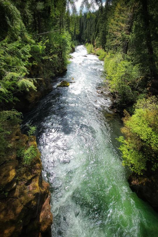
Photo
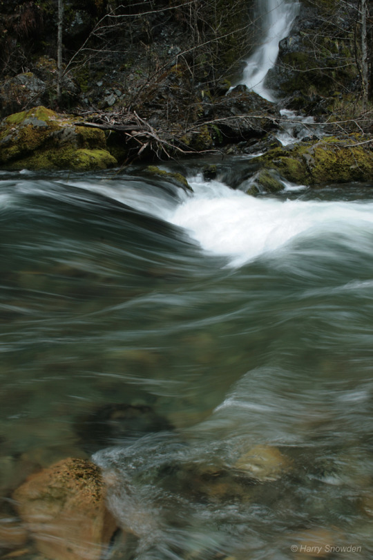
Seasonal Waterfall - Oregon
Harry Snowden
#photographers on tumblr#pnw#oregon#Siskiyou National Forest#sucker creek#original photography#nature#wilderness#waterfalls#oregon waterfalls
104 notes
·
View notes
Text
Outdoor Adventure in Medford OR
If you're looking for a great outdoor adventure in Medford OR, then there are plenty of things to do. From hiking and camping to swimming and fishing, you'll find that there's a lot to explore. But what are some of the best places to go in the area?

Bear Creek Park
Medford, Oregon is a great place to visit for an outdoor adventure. This city is located in the Rogue River valley. There are several parks and other attractions to enjoy while you are here. Whether you want to hike, ride a bike, or just relax in nature, there are plenty of things to do in this beautiful region.
Bear Creek Park is an excellent place for a family outing. It has lots of hiking trails, sports facilities, and an open-air amphitheater. The park is also home to three acres of wildlife refuge.
Bear Creek Park is a popular spot for people and dogs in southern Oregon. While the area is primarily used for BMX and skating, there are also plenty of hiking trails for all ages.
Crater Lake National Park
Crater Lake National Park is a must-see destination for visitors to the Pacific Northwest. It is located in southern Oregon near the city of Medford, and is a beautiful and awe-inspiring sight to see.
Crater Lake is known for its deep and pure lake. Located in the Cascade Mountains, it is the ninth deepest in the world. When the lake freezes, it receives up to 100 inches of snow.
Applegate Lake
Medford, Oregon is a great place for outdoor adventure. The town is located in the Rogue River Valley, which is rich in natural beauty. A short drive will take you to some of the best attractions in the region.
One of the best attractions is Applegate Lake. This scenic lake is located in the Rogue River Valley. You can enjoy great fishing, hiking, swimming, boating and more!
Applegate Lake is surrounded by a variety of hiking trails. There is also a boat ramp. During the summer months, you can enjoy a day of sun and fun at the lake. It is a great place to relax and unwind.

DANCIN Vineyards
DANCIN Vineyards is one of the most popular wineries in the Medford region. This family-owned business offers award-winning wines. They produce pinot noir, chardonnay, syrah, and port. A tasting room is located within the vineyard, so you can enjoy a glass of wine while overlooking the Rogue Valley. You can also take a tour.
One of the most beautiful places to visit in Oregon is the town of Medford. It's known for its breathtaking outdoor adventures, as well as its world-class vineyards. The city is surrounded by the Rogue River and the Cascade Mountains. There are a number of wineries and activities in the area, as well as parks and a variety of other fun attractions.
Samuel H. Boardman
There's no shortage of outdoor adventures in Medford, Oregon. The city is situated along the coast of the Pacific Ocean. You can explore the area's history or just relax on a beautiful beach. But if you want to get some real exercise, head out on the trail.
Siskiyou Mountain Park
Siskiyou Mountain Park is a beautiful area for an outdoor adventure. It's located near Medford, Oregon, and offers a variety of hiking and horseback riding trails.
Hilton Rd Medford OR is a great place to stay if you're planning a trip to the Rogue Valley. It's a short drive from the Rogue Valley International-Medford Airport and also features a plethora of shops and restaurants to keep you entertained on the go. The hotel also boasts a great swimming pool and a convenient fitness center.
There are also several other trails in the area. For example, the Natural Bridges Cove trail is a narrow and steep hiking path that features unique rock formations.
Whether you're traveling to the area for the first time or you're a longtime resident, there are a lot of activities to enjoy near Forest Hills Dr in Medford. The area is a great place to enjoy the natural scenery of Oregon. There are a number of hiking trails and a variety of recreational activities to keep you busy.
If you're looking for a challenging hike, you can climb to the top of Table Rock. This scenic mountain is a flat top lava flow jutting out of the ground. A steep climb is needed to reach its top.
You can also try the Canyon Falls Trail. The trail starts from the same trailhead. It is a two-mile hike with a waterfall on the trail.
Other nearby attractions include the Oregon State Hospital Museum and the Deepwood Museum and Gardens. These museums are excellent for exploring the history of the region. Located just one mile from the trailhead, they have lots of parking.

Medford builders
There are a number of reasons why you may choose to build a new home. For example, it's less expensive than buying a pre-built house. Plus, you'll be able to make it exactly the way you want it to be.
The first step is to find a good home builder in Medford. You can search for a company through the internet, or by looking for photos of their completed projects.
When you're searching for a new construction builder, you should look for companies that have a track record of completing high-quality projects on time. Ideally, you'll also want a company that has experience working with the zoning regulations of the city where you're building.
Choosing a good Medford builders can be a daunting task. But with the help of a reputable company, the process can be simple and stress-free.
Revolution Builders, LLC
3619 Aviation Way, Medford, OR 97504
(541) 210-3205
https://revolution-builders.com/
0 notes
Text

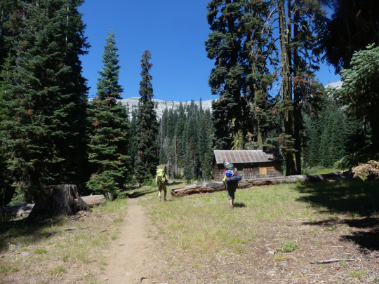


Klamath National Forest, California
Marble Mountain Wilderness
I had a lovely hike up to the camp for another week of trail work (well, 4 days planned for actually work) heading up Canyon Creek in the Marble Mountain Wilderness of Kamath National Forest.
#hiking#nature#landscape#travel#hike#outside#California#mountains#KlamathNF#Klamath National Forest#Siskiyou County#volunteering#wilderness#trail work#trail#backpacking#wildlife#toad#burned#Canyon Creek#Marble Mountain
3 notes
·
View notes
Text


Turbinellus floccosus, the Wooly Chanterelle, family Gomphaceae, growing among Western Hemlock and Douglas Fir leaf litter on a shaded western slope.
Final two images are 40 image focus stacks
Rogue-Siskiyou National Forest, Oregon
#Turbinellus floccosus#Turbinellus#Gomphaceae#chanterelle#fungi#mushrooms#mycology#forest floor#nature photography#mushroom photography#macrophotography#nikon#105mm#focus stacking#original photographers#photographers on tumblr
19 notes
·
View notes
Photo
If you're looking for a lower-traffic area to visit, Rogue River-Siskiyou National Forest is absolutely gorgeous. (2252x3377) (OC) https://ift.tt/VkdgLcr
0 notes
Text
Tell me again that climate change/global warming is made up. I live in Oregon & have been through the Siskiyou Forest, such a shame. 😢
0 notes
Last Seen Blogs

itminanse
itminan

4ling4all-blog
LING4ALL

datmunalit
Đất mùn Alit

delirioussky
judy

sihagdeep
Untitled