#Software CAD
Explore tagged Tumblr posts
Visit Tumblr Blog
Explore Tumblr blogs with no restrictions, modern design and the best experience.
Last Seen Tumblr Blogs


Fun Fact
In 2020, Tumblr had 29.4 million users in the US.
Text
Best BIM Tools in 2025 and Selecting the Right BIM Software

BIM is a comprehensive approach in the AEC realm, and its applications and tools hold a significant position. It is vital to choose the right BIM software for project requirements, coordination, and efficiency. Here’s a detailed, curated list of the best BIM software and key factors for selecting it.
#bim modeling services#3d bim services#mep shop drawings#building information modeling#interior visualization#clash detection#revit families creation#3d cad drawings#shop drawing services#bim company#top bim software#best bim tools
2 notes
·
View notes
Text
it's funny when a manga is an extremely cliched premise but with the author's extremely niche special interest shoved in. overpowered isekai about architecture. sparkly shoujo series about how cool and sexy manzai comedians are. weird harem romcom about anthropomorphized cockroaches with extremely detailed portrayals of specific species. that sort of thing
#actually the isekai i'm thinking about might have been about CAD software specifically#like they had a power that worked like it#in extreme detail
2 notes
·
View notes
Text
"i drew this in powerpoint" - not impressive, they have a vector drawing toolset easily accessible.
"I modeled this in sketchup" - impressive, stop doing that
#blender: feels intimidating the first month but after that it's very usable and convenient#sketchup: starts of seemingly straightforward and then somehow gets worse and worse the more you use it#and if youre doing pure archviz use like. rhino or something. if youre cadding. use a an actual proper cad software.
4 notes
·
View notes
Text
Hello jon Cup i made for CAD in school


#the magnus archives#tma#CAD stands for computer aided design if you didn't know that btw#hello jon apologies for the deception#I'm literally so proud of myself with this#The software is called Fusion 360 btw#fusion 360
6 notes
·
View notes
Text
when all else fails, close the program and re-fucking-start
#this is about solidworks#solidworks#damn i cant believe theres a tag for that#i have a love-hate relationship with this software#right now im experiencing hate#engineering#mechanical engineering#college#cad software
4 notes
·
View notes
Text

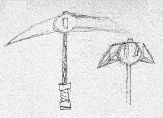
Back when I tried out this eye on Onyx, Terry got a doodle too. n some angles practice on that silly pickaxe head of his
#mx creations#original art#traditional art#Memories of Solitude#oc#Te-ka-ne-ru-t'Mon#I picked a tricky shape I think I should model it in my CAD software and have a reference aid…
8 notes
·
View notes
Text
4 notes
·
View notes
Text
desperately need to figure out a way to clone or like 3d print the case of the Sony HB-F1XD and shove modern computer parts in there, that is the most sexual machine on this earth and i need to install linux on it as soon as fate allows.
4 notes
·
View notes
Text
I took a couple CAD modeling classes back in high school and it's so sad that I forgot literally all of it because it would have been so useful for making sims content :(
#i really liked those classes#so it's not like i forgot cuz i hated it#its just been ages#and i don't have access to the software they taught us on#and i dunno if that knowledge would translate to another cad program. i haven't tried.#simoleon
2 notes
·
View notes
Text
How CAD Technology Transforms Accuracy and Efficiency in Land Surveying

Land surveying is a critical process in the fields of construction, engineering, and land development. It involves measuring and mapping the terrestrial or three-dimensional space to determine boundaries, land features, and property lines. Traditionally, land surveying relied heavily on manual techniques and rudimentary tools, leading to time-consuming and often error-prone results. However, with the advent of Computer-Aided Design (CAD) technology, the landscape of land surveying has transformed dramatically. CAD has brought about significant improvements in accuracy and efficiency, revolutionizing the industry. In this blog post, we will delve into the various ways CAD enhances land surveying and explore its benefits in detail.
The Role of CAD in Land Surveying
CAD, or Computer-Aided Design, is a technology used for creating, modifying, analyzing, and optimizing designs. In the context of land surveying, CAD software helps surveyors create detailed and precise maps and plans of land areas. The integration of CAD in land surveying involves the use of specialized software that allows surveyors to input data, process measurements, and generate accurate digital representations of physical spaces.
Enhanced Accuracy
One of the most significant advantages of CAD in land surveying is the enhanced accuracy it provides. Traditional surveying methods often involved manual calculations and hand-drawn maps, which were susceptible to human error. In contrast, CAD software offers tools that automate many of these processes, reducing the likelihood of mistakes. Here are some ways CAD improves accuracy:
1. Precision in Measurements: CAD software can handle and process complex mathematical calculations with precision. Surveyors can input raw data collected from the field directly into the software, which then accurately converts these measurements into detailed maps and models. This eliminates errors associated with manual data entry and calculation.
2. Detailed and Scalable Maps: CAD allows for the creation of highly detailed and scalable maps. Surveyors can zoom in and out without losing accuracy, enabling them to examine specific areas closely and ensure every detail is accounted for. This level of detail is crucial for identifying potential issues and making informed decisions.
3. Real-Time Data Processing: Modern CAD software can process data in real time, providing surveyors with immediate feedback. This capability allows for quick adjustments and corrections in the field, ensuring that the final survey is as accurate as possible.
4. Integration with GPS and GIS: CAD software often integrates seamlessly with Global Positioning System (GPS) and Geographic Information System (GIS) technology. This integration allows surveyors to import precise location data directly into their CAD models, further enhancing accuracy and providing a comprehensive view of the surveyed area.
Increased Efficiency
Efficiency is another key area where CAD excels in land surveying. The traditional surveying process was labor-intensive and time-consuming, often requiring surveyors to spend days or even weeks in the field. CAD technology streamlines many aspects of this process, leading to significant time savings and increased productivity. Here’s how CAD boosts efficiency in land surveying:
1. Automated Data Processing: CAD software can automate many of the repetitive and time-consuming tasks involved in land surveying. For example, it can automatically generate contour lines, calculate areas and volumes, and create cross-sections. This automation reduces the workload on surveyors and speeds up the overall process.
2. Simplified Data Management: Managing large amounts of data can be challenging, especially in large-scale land surveying projects. CAD software offers robust data management tools that allow surveyors to organize, store, and retrieve data easily. This simplifies the workflow and ensures that all information is readily accessible when needed.
3. Collaborative Capabilities: CAD software often includes collaborative features that enable multiple team members to work on the same project simultaneously. This collaborative approach enhances communication and coordination, leading to faster completion times and fewer misunderstandings.
4. Efficient Fieldwork: With CAD, surveyors can use mobile devices and specialized equipment to collect data in the field more efficiently. This data can be uploaded to the CAD software on the go, reducing the need for repeated site visits and minimizing downtime.
Visualization and Analysis
Visualization and analysis are critical components of land surveying, and CAD technology excels in these areas as well. The ability to create detailed visual representations of surveyed areas and perform in-depth analyses is invaluable for surveyors, engineers, and developers. Here are some ways CAD enhances visualization and analysis:
1. 3D Modeling: CAD software enables surveyors to create three-dimensional models of land areas. These 3D models provide a realistic representation of the terrain, allowing for better analysis and planning. Stakeholders can visualize the land’s topography, identify potential challenges, and make informed decisions based on accurate data.
2. Overlaying Data: CAD allows for the overlaying of different types of data on a single map. For example, surveyors can combine topographical data with utility lines, property boundaries, and environmental features. This comprehensive view helps in identifying potential conflicts and planning accordingly.
3. Simulation and Scenario Planning: CAD software can simulate various scenarios and predict their outcomes. For instance, surveyors can model the impact of construction on a particular area, assess potential drainage issues, or analyze the effects of environmental changes. This capability aids in proactive planning and risk management.
4. Detailed Reports and Documentation: CAD software can generate detailed reports and documentation based on the surveyed data. These reports can include measurements, calculations, maps, and 3D models, providing a comprehensive overview of the surveyed area. Such documentation is essential for legal, regulatory, and planning purposes.
Cost Savings
The improvements in accuracy, efficiency, and visualization brought about by CAD also translate into significant cost savings. By reducing errors and streamlining processes, CAD helps surveyors and their clients save money in various ways:
1. Reduced Rework: Accurate surveys mean fewer mistakes and less rework. Errors in traditional surveys often led to costly revisions and delays. CAD minimizes these errors, ensuring that the project stays on schedule and within budget.
2. Optimized Resource Allocation: Efficient data processing and management allow surveyors to optimize the use of resources, including time, labor, and equipment. This optimization leads to cost savings and better project management.
3. Minimized Site Visits: With the ability to process and analyze data remotely, CAD reduces the need for multiple site visits. This not only saves time but also reduces travel and labor costs.
4. Improved Decision-Making: Accurate and detailed surveys provide valuable insights that aid in decision-making. This leads to better project planning, fewer unforeseen issues, and more efficient use of resources, all of which contribute to cost savings.
Future Prospects of CAD in Land Surveying
As technology continues to advance, the role of CAD in land surveying is expected to grow even more significant. Emerging technologies such as Building Information Modeling (BIM), drones, and LiDAR (Light Detection and Ranging) are being integrated with CAD software, further enhancing its capabilities. Here are some future prospects for CAD in land surveying:
1. Integration with Drones: Drones equipped with high-resolution cameras and LiDAR sensors can capture detailed aerial imagery and topographical data. This data can be imported into CAD software for precise mapping and analysis. The use of drones reduces the time and effort required for fieldwork and provides access to hard-to-reach areas.
2. Building Information Modeling (BIM): BIM is a digital representation of the physical and functional characteristics of a building. Integrating BIM with CAD allows for a seamless transition from land surveying to construction planning and management. This integration improves collaboration between surveyors, architects, and engineers, leading to more efficient project execution.
3. Augmented Reality (AR) and Virtual Reality (VR): AR and VR technologies can enhance the visualization capabilities of CAD software. Surveyors and stakeholders can use AR and VR to explore 3D models in an immersive environment, gaining a better understanding of the terrain and potential challenges. This immersive experience aids in decision-making and improves communication.
4. Artificial Intelligence (AI) and Machine Learning: AI and machine learning algorithms can analyze large datasets quickly and accurately. When integrated with CAD, these technologies can automate complex analyses, identify patterns, and predict potential issues. This capability enhances the efficiency and accuracy of land surveying.
Conclusion
CAD has revolutionized the field of land surveying by improving accuracy, efficiency, and visualization capabilities. The precision and automation offered by CAD software reduce errors and streamline processes, leading to significant time and cost savings. As technology continues to evolve, the integration of CAD with emerging technologies such as drones, BIM, AR, VR, and AI will further enhance its capabilities, making land surveying even more efficient and accurate. For surveyors, engineers, and developers, embracing CAD technology is not just an option but a necessity for staying competitive and delivering high-quality results in today's fast-paced and demanding environment.
#Land Surveying#outsource cad drafting services#Surveying#Land Survey#Land Surveying Software#Land Survey Drafting Services#Land Survey CAD Drafting Services#Alta Survey#Subdivision Plats#Title Survey#Pipeline Surveys#Construction Survey#Site Planning Survey#Boundary and Location Survey#Topographic Survey#Residential Mortgage Survey#Tower Survey#Radius Map#Utility survey
2 notes
·
View notes
Text
Bring Your Home Design and Construction Dreams to Life with Pro-Grade CAD Software!
Bring Your Home Design and Construction Dreams to Life with Pro-Grade CAD Software! #sale #cad #software #ashampoo #homedesign #interiordesign #architecture
Here’s the link to check out the three bundle options with up to six items. Looking for the tools that’ll help you bring your ideal space to life? This bundle of 3D CAD software from Ashampoo has everything you need to design your dream home, create an amazing landscape, or nail your DIY remodel! Including pro-grade software like 3D CAD Professional 11, 3D CAD Architecture 11, Home Design 9, and…

View On WordPress
2 notes
·
View notes
Text
thinkign about making a gale costume for halloween this year..i already have a mullet and purple cloak. and a gay little earring. and a staff
#though honestly maybe ill try machining his earring since the one i have is six pointed star rather than 8 pointed.. have to get cad softwar#id have to dye my hair to add grey streaks but honestly thatd just make me hotter. and id have to get a fake beard#sadly my purple cloak is a cloak and not a robe but i feel like it would still be kind of recognizable#rayposting#bg3
2 notes
·
View notes
Text
ActCAD to zaawansowane oprogramowanie CAD służące do tworzenia i edycji plików projektowych w formatach dwg, dxf, dgn i innych. ActCAD wyposażony jest w konwerter pdf do dwg i wiele innych przydatnych narzedzi. ActCAD to niska cena i zaawansowane funkcje CAD
#cad#cad software#actcad#cad editor#dwg#dxf#pdf conwerter#pdf2cad#pdf2dxf#pdf2dwg#jpg2dxf#dwg editor
2 notes
·
View notes
Text
3d printing something you designed is like magic you charge up with hyperfocus
2 notes
·
View notes
Photo
"Sorry! You cannot build any larger". Cowards. Reactionaries. Homophobes.
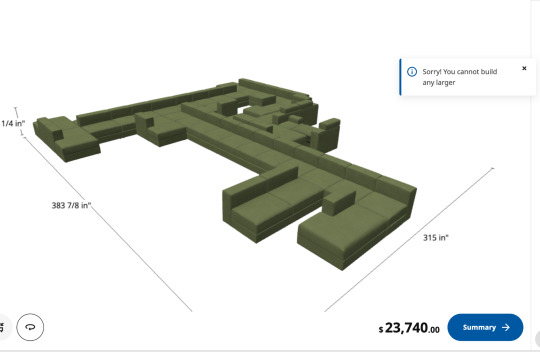
Ikea’s modular sofa designer is Game of the Year
27K notes
·
View notes
Text
Top Benefits of Using CAD Drawing Services for Your Projects

In today’s fast-paced and precision-driven industries, relying on traditional drafting methods can slow down your workflow and expose your project to costly errors. That’s why CAD (Computer-Aided Design) drawing services have become an essential tool for businesses and professionals in engineering, architecture, manufacturing, and construction.
From accelerating design timelines to ensuring top-notch accuracy, CAD Drawing Services offer a wide range of benefits that contribute directly to the quality and success of your projects.
In this blog post, we’ll explore the top benefits of using CAD drawing services, how they transform project outcomes, and why integrating them into your workflow can provide a lasting competitive advantage.
1. Unmatched Precision and Accuracy
One of the most significant advantages of CAD drawing services is the high level of precision they offer. Manual drafting is susceptible to human errors such as miscalculations or inconsistent scaling. CAD tools eliminate these problems by allowing:
Exact measurements with sub-millimeter accuracy
Clear dimensioning and annotation
Error detection in real time
For industries like structural engineering or mechanical design, where even a slight mistake can result in massive rework or structural failure, CAD ensures reliable outcomes every time.
2. Faster Turnaround Times
Speed is critical in project execution. CAD drawing services can drastically reduce the time it takes to produce detailed technical drawings. Thanks to features like:
Templates and reusable components
Automated drawing tools
Quick revisions and version control
Design teams can complete and deliver drafts much faster than with manual methods. This not only improves internal efficiency but also helps meet tight client deadlines.
3. Easy Revisions and Modifications
Projects evolve — whether it’s client feedback, regulatory changes, or internal design improvements. With traditional drafting, every change might mean redrawing a large section. With CAD drawing services, you can:
Update specific components without affecting the entire design
Maintain a history of revisions
Reduce turnaround time for changes
This flexibility keeps your workflow agile and responsive to evolving project requirements.
4. Enhanced Visualization and 3D Modeling
2D drawings are useful, but 3D CAD models take design clarity to a whole new level. With CAD services, you can:
Visualize the final product in three dimensions
Rotate and view components from multiple angles
Create photorealistic renderings for client presentations
This clarity helps stakeholders understand the design better and ensures everyone is aligned before production or construction begins.
5. Improved Collaboration Across Teams
Modern CAD platforms allow multiple team members to work on the same project simultaneously, whether they’re across the office or around the globe. With cloud-based and real-time collaborative tools, CAD services enable:
Live feedback and markup sharing
Centralized file management
Streamlined communication between engineers, designers, and contractors
As a result, teams can collaborate more efficiently and avoid miscommunication that could delay the project.
6. Cost Efficiency and Waste Reduction
By reducing errors, streamlining processes, and shortening timelines, CAD drawing services contribute significantly to cost savings. Here's how:
Fewer physical prototypes are needed thanks to virtual testing
Less material waste due to accurate measurements
Reduced labor hours on revisions and corrections
Smarter planning with CAD often translates to smarter budgeting.
7. Standardized and Compliant Designs
CAD drawings can be generated to meet specific industry and regional standards. This ensures:
Compliance with building codes and regulations
Easy submission for permit approvals
Fewer issues during inspections
Most CAD software includes libraries of standardized components and formats, which help maintain quality and consistency across all drawings.
8. Integration with Other Tools and Technologies
CAD doesn’t operate in isolation. It integrates seamlessly with other systems like:
BIM (Building Information Modeling) for construction projects
CAE (Computer-Aided Engineering) for stress analysis and simulation
CAM (Computer-Aided Manufacturing) for production processes
This interoperability enables a full digital workflow—from concept to completion without needing to convert or redraw designs.
9. Scalability for Large Projects
For large-scale projects that require dozens or even hundreds of detailed drawings, CAD Drafting Services are scalable and can manage:
Complex architectural layouts
Multi-discipline engineering designs
Detailed part libraries for mass production
With layered drawings, referencing systems, and easy duplication features, managing big projects becomes more organized and efficient.
10. Data Storage and Archiving
CAD files are easy to store, retrieve, and update, unlike physical drawings that degrade or get misplaced over time. Benefits include:
Digital backups for disaster recovery
Version control to track progress
Easy access for audits and future renovations
Having a well-organized digital archive ensures long-term asset value and reference for future projects.
11. Customizability and Flexibility
Every project is unique, and CAD services are adaptable to:
Various industries (architecture, mechanical, civil, electrical, etc.)
Different drawing standards (ISO, ANSI, DIN, etc.)
Specific client or regulatory requirements
Whether you need construction blueprints, MEP layouts, or electrical schematics, CAD drawing services can be customized to fit your exact needs.
12. Professional Output and Presentation
In client-facing industries, presentation matters. CAD services help you deliver:
Professionally labeled and dimensioned drawings
Clean and scalable output formats (PDF, DWG, DXF)
Renderings and walkthroughs for presentations
This level of quality enhances your brand reputation and builds trust with clients and stakeholders.
Real-Life Use Cases Across Industries
Construction & Architecture
CAD drawing services support everything from floor plans and elevations to plumbing layouts and structural frameworks, helping contractors visualize every phase before ground is broken.
Mechanical & Industrial Design
Manufacturers use CAD for machine part designs, assemblies, and prototypes, often integrating it with CAM for direct production.
Electrical & Electronics
Engineers use CAD for PCB layouts, wiring diagrams, and control systems, ensuring clarity in both design and troubleshooting.
Urban Planning & Infrastructure
CAD helps city planners design roads, drainage systems, and zoning layouts, contributing to smarter and more sustainable development.
Outsourcing CAD Drawing Services – A Smart Business Move
While some companies choose to build in-house CAD teams, many prefer outsourcing to expert service providers. The benefits of outsourcing include:
Reduced overhead and HR costs
Access to specialized CAD talent
Scalability during peak demand
Focus on core business functions
A reliable CAD service partner like Asset Eyes ensures that your drawings are delivered with technical accuracy, industry compliance, and visual clarity—all while saving you time and money.
Partner with Asset Eyes for Expert CAD Drawing Services
Looking for dependable and professional CAD drafting solutions? Asset Eyes offers a full range of CAD services tailored to meet the unique needs of your industry.
Whether you need:
2D floor plans
3D mechanical models
Structural detailing
Electrical and MEP schematics
…our team is ready to deliver precise, high-quality drawings that keep your projects on track.
With a deep commitment to quality, timelines, and confidentiality, Asset Eyes is your trusted CAD partner for projects of all sizes.
Contact us today to learn more or request a free consultation.
Conclusion
In a world where accuracy, speed, and collaboration are paramount, CAD drawing services offer undeniable value to any project. From concept development to project execution, they streamline workflows, minimize errors, and deliver professional results that align with modern expectations.
If you’re not already leveraging CAD services, now is the time to do so—and if you want results you can trust, Asset Eyes is here to help.
#cad drafting services#solidworks design#USA#Business#software#general assembly drawing#cad drawing services#HVAC equipment design#HVAC CAD drafting#2d drafting in solidworks#solidworks 2d drafting#solidworks drafting services
0 notes