#Soil Data logger
Explore tagged Tumblr posts
Visit Tumblr Blog
Explore Tumblr blogs with no restrictions, modern design and the best experience.
Last Seen Tumblr Blogs


Fun Fact
The most popular pages on Tumblr are about Minecraft, GIFs, and David J. Peterson.
Text
#temperature data logger manufacturers in India#Data logger#Blood Bank Monitoring#Soil Data logger#Blood bank data logger
0 notes
Text
https://www.futureelectronics.com/p/semiconductors--analog--sensors--humidity-dew/sht41i-ad1b-r2-sensirion-9164920
Digital humidity sensor, USB data, Soil moisture sensor, Temperature sensor
SHT41I-AD1B-R2
#Sensirion#SHT41I-AD1B-R2#Sensors#Humidity / Dew Sensors#digital#USB data#Soil moisture sensor#Engine coolant#humidity monitor#USB data logger software#home#Remote humidity sensor#humidity sensor switch
1 note
·
View note
Text
https://www.futureelectronics.com/p/semiconductors--analog--sensors--humidity-dew/sht21-tr-0-4ks-sensirion-5049816
Dew point sensor, high pressure humidity sensor, data logger, soil moisture
SHT21 Series 3 V -40 to +125 °C Digital Humidity & Temperature Sensor IC - DFN-6
#Sensirion#SHT21-TR-0.4KS#Sensors#Humidity / Dew Sensors#dew point sensor#high pressure#data logger#soil moisture#what is a Sensors#chip#Digital relative humidity sensor#humidity transmitter#digital meter#Moisture sensors#home
1 note
·
View note
Text
Internet of forest things
(...)
Wallrabe and her fellow researchers are working on a range of devices that will be deployed from the ground to the treetops, transmitting data from Germany’s Black Forest to their labs at the University of Freiburg. At the same time, scientists and engineers at other companies are also focused on making their devices unobtrusive and, ultimately, self-sustaining.
Silvanet Wildfire Sensor
Time is of the essence when fighting forest fires. Sensors attached to trunks “smell” tell-tale gases like hydrogen and carbon monoxide, and alert firefighters within the first hour—before satellites or cameras can spot open flames. German startup Dryad Networks has built AI into its solar-powered sensors to ensure that they can distinguish between real fires and, say, passing diesel trucks.
Treevia
Digital dendrometers relieve foresters of tedious work. As trees grow, the elastic band wrapped around their trunk stretches and transmits data directly to a computer. The lightweight device from Brazilian startup Treevia can even be attached to saplings. It also contains a humidity and heat sensor, providing insights into climatic impacts on reforested areas.
The Guardian
What does it take to catch illegal loggers or poachers? A smartphone is a good start. Rainforest Connection’s recycled, solar-powered smartphone listens for the sound of chain saws or gunshots within a 1-mile radius. The recordings are transmitted to the cloud for analysis and alert local authorities in near real time. This device also provides insights into the distribution and calling behavior of animals.
BiodivX Drone
As animals move through trees, they shed DNA through feces, skin, and hair. This innovative drone collects what is known as environmental DNA (eDNA) from leaves and branches—with particles sticking to its adhesive strips. Scientists from Switzerland programmed the drone so it can navigate autonomously through dense forests and hover steadily around branches to take samples.
Leaf Sensor
Wallrabe and her team at the University of Freiburg have developed a glass capsule that measures gas exchange between a leaf and its surroundings. It can detect specific chemicals that trees emit under stress, for example, in the event of a drought, infestation, or disease. The capsule is transparent so that sunlight can reach the leaf without impairing its function.
Plant-e
When sunlight is limited, most devices are powered by batteries. Plant-e, a Dutch company spun out of Wageningen University, makes use of a natural process: Plants produce organic material through photosynthesis; some they use for growth, the rest ends up into the soil. Bacteria break down this material and release electrons that Plant-e uses to power its sensors....
2 notes
·
View notes
Text
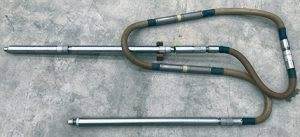
Understanding Borehole Geophysical Logging with the PS Logger® Probe
In the realm of civil engineering, offshore construction, and geotechnical investigations, obtaining accurate subsurface data is paramount. Without it, designing safe foundations, evaluating soil conditions, and assessing geological risks become speculative endeavors. This is where the PS Logger® probe stands out—a revolutionary tool engineered for fast, precise, and safe measurement of seismic wave velocities in boreholes.

🔍 What is Borehole Geophysical Logging?
Borehole geophysical logging is a technique used to measure the physical properties of subsurface formations by lowering specialized instruments into boreholes. These measurements provide invaluable data on the geological characteristics of the area, aiding in:
Foundation design
Earthquake engineering
Offshore construction
Environmental assessments
Traditional logging methods often require external energy sources, such as explosives or weight drops, to generate seismic waves. However, these methods can be cumbersome, costly, and sometimes hazardous.
⚙️ Enter the PS Logger® Probe
The PS Logger® probe, developed by Robertson Geo, revolutionizes borehole geophysical logging by incorporating an internal solenoid-operated hammer. This innovative design allows for the generation of seismic waves without the need for external energy sources, ensuring quicker, safer, and more efficient logging operations.
Key features of the PS Logger® include:
Dual-wave measurement: Simultaneously measures P-wave (compression) and S-wave (shear) velocities.
High-resolution data: Captures full waveforms with sample rates as low as 2.5 microseconds.
Robust design: Built to withstand harsh environments, including deep marine conditions.
User-friendly operation: Compatible with industry-standard software for seamless data acquisition and analysis.
📈 Why Measure P-Wave and S-Wave Velocities?
Understanding the speeds of seismic waves in subsurface materials provides critical insights:
P-wave velocity: Indicates material density and compressional stiffness.
S-wave velocity: Relates directly to shear strength and rigidity of soils or rocks.
When combined with bulk density measurements, this data enables the calculation of small-strain moduli such as:
Young’s modulus
Shear modulus
Bulk modulus
These parameters are essential for designing safe foundations, predicting soil behavior under load, and modeling geotechnical structures. Simply put, better velocity data translates to better engineering decisions.
🌍 Global Applications of the PS Logger®
The PS Logger® has been deployed worldwide across various challenging environments:
Civil Engineering Projects: Bridges, tunnels, dams, and deep foundations rely on accurate subsurface profiles.
Offshore Construction: Oil platforms, wind farms, and subsea pipelines benefit from reliable geophysical data in extreme marine conditions.
Geotechnical Investigations: Site characterization for urban development, mining, and research all gain from high-quality seismic logs.
Its rugged design and user-friendly operation have made it the go-to choice for professionals seeking precise subsurface data.
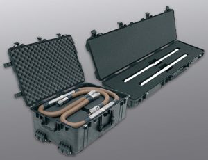
🛠️ Deployment and Compatibility
The PS Logger® integrates seamlessly with Robertson Geo’s proven surface equipment, including:
Micrologger2 and Winlogger software for data acquisition and processing
Various winch systems ranging from mini winches to 3000m marine winches
Sheaves rated for 2k and 3k loads for reliable deployment
This compatibility ensures that whether your site is onshore or offshore, you have the right tools to deploy and collect data efficiently.
🎓 Training and Support
At PSLogger.com, we believe that great equipment must be backed by excellent support. We provide a comprehensive range of resources, including:
Video tutorials: Covering probe assembly, data collection, and analysis.
Technical guides: Offering insights into probe maintenance and troubleshooting.
Expert assistance: Our team is ready to support you with any queries or challenges.
This ensures operators at every level can confidently use the PS Logger® and maximize its capabilities.
✅ Why Choose the PS Logger®?
No external seismic source required: Safer and simpler operation.
High-resolution data: With sample rates as low as 2.5 microseconds.
Durable, compact design: Suited for harsh environments.
Compatible with industry-leading surface systems: Ensuring seamless integration.
Trusted worldwide: Deployed across thousands of projects globally.
Whether you're conducting routine site investigations or complex offshore surveys, the PS Logger® delivers the seismic insights you need quickly and accurately.
📞 Get Started with PSLogger.com
Ready to upgrade your seismic logging capabilities
Download detailed product literature
Access our video tutorial library
Request pricing and availability
Contact our expert support teams
We're here to help you take your projects to the next level with smarter, safer, and more efficient seismic data acquisition.
Conclusion
Accurate subsurface seismic data is the foundation of safe, successful engineering projects. The PS Logger® delivers this data with a unique blend of innovation, simplicity, and reliability—all from a single borehole and without external energy sources.
Explore deeper insights, accelerate your workflow, and build with confidence using the PS Logger®.
👉 Visit us today at PSLogger.com to learn more! 🌐✨
1 note
·
View note
Text
Temperature Data Logger Market Growth Drivers Transforming Global Industry Dynamics Rapidly
The Temperature Data Logger Market is witnessing significant growth driven by several critical factors shaping its expansion globally. Temperature data loggers are essential devices that record temperature over time, ensuring safety, quality, and compliance in various sectors such as pharmaceuticals, food and beverage, healthcare, and logistics. Understanding the key drivers propelling this market helps businesses and investors capitalize on emerging opportunities and address evolving industry needs.

One of the primary drivers of the Temperature Data Logger Market is the increasing demand for reliable temperature monitoring solutions in the pharmaceutical and healthcare industries. Maintaining strict temperature control during the storage and transportation of vaccines, medicines, and biological samples is critical to preserve their efficacy and safety. With the surge in vaccine distribution globally, especially highlighted by the COVID-19 pandemic, the need for temperature data loggers has intensified. These devices help ensure that sensitive products remain within required temperature ranges throughout the supply chain, reducing spoilage risks and compliance violations.
Technological advancements are another vital driver fueling the market’s growth. Modern temperature data loggers are equipped with wireless connectivity, real-time monitoring, and cloud-based data management features, allowing users to track temperature variations remotely and receive instant alerts in case of anomalies. The integration of Internet of Things (IoT) technology has enhanced the efficiency and accuracy of these devices, making them more user-friendly and adaptable across diverse applications. Innovations such as compact designs, longer battery life, and multi-parameter sensing capabilities have broadened their usability, thereby increasing market penetration.
Strict government regulations and industry standards related to temperature control and monitoring have also accelerated the adoption of temperature data loggers. Regulatory bodies worldwide mandate precise temperature tracking in sectors like food processing, pharmaceuticals, and cold chain logistics to ensure consumer safety and product quality. Compliance with regulations such as the FDA’s Good Manufacturing Practices (GMP), WHO guidelines, and HACCP (Hazard Analysis and Critical Control Points) is driving businesses to invest in advanced temperature monitoring systems. These regulatory requirements create a steady demand for temperature data loggers, especially in regions with stringent quality control standards.
The growth of cold chain logistics is another significant market driver. With the rise in global trade of perishable goods, including fresh food, seafood, and temperature-sensitive pharmaceuticals, efficient cold chain management has become paramount. Temperature data loggers play a crucial role in monitoring environmental conditions during transportation and storage, reducing the risk of product degradation. Increasing consumer awareness about food safety and quality further supports the expansion of cold chain infrastructure, indirectly boosting the demand for temperature data logging solutions.
Furthermore, expanding end-use industries contribute to market growth. Apart from healthcare and food, sectors such as agriculture, chemical manufacturing, and environmental monitoring require precise temperature measurement to optimize operations and maintain product integrity. For example, in agriculture, monitoring soil and storage temperatures helps improve crop yields and reduce wastage. Similarly, in chemical industries, maintaining controlled temperature conditions is essential for safe processing and storage of volatile substances. The broadening application scope enhances the overall demand for temperature data loggers.
Cost-effectiveness and ease of use also act as drivers for widespread adoption. Many temperature data loggers are now designed to be plug-and-play devices that require minimal technical expertise, encouraging small and medium-sized enterprises to implement temperature monitoring solutions. Additionally, the availability of affordable models without compromising accuracy has made these devices accessible to a larger customer base. This democratization of temperature monitoring technology is expected to contribute substantially to market growth in emerging economies.
The rising trend of digitalization and Industry 4.0 initiatives across manufacturing and supply chain operations further supports the Temperature Data Logger Market. Organizations aiming to enhance transparency, traceability, and operational efficiency adopt advanced temperature monitoring tools integrated with data analytics platforms. The insights generated from temperature data help businesses make informed decisions, reduce wastage, and comply with safety standards. The synergy between digital transformation and temperature data logging presents a promising growth avenue.
Lastly, increasing awareness of sustainability and reduction of food and drug wastage is encouraging industries to implement efficient temperature control measures. Temperature data loggers provide actionable insights that help reduce losses caused by improper storage conditions, supporting eco-friendly practices and cost savings. As environmental concerns become a priority globally, this driver will play a more significant role in shaping market dynamics.
In summary, the Temperature Data Logger Market growth is propelled by multiple intertwined drivers: escalating demand for temperature-controlled logistics, technological innovations, regulatory compliance, expansion of end-use industries, and the digital transformation of supply chains. These factors collectively create a robust ecosystem supporting market expansion. Companies investing in research, product development, and strategic partnerships are well-positioned to leverage these growth drivers and capture emerging opportunities in this evolving market landscape.
0 notes
Text
How Do IoT Data Loggers Enhance Data Collection?
In the age of digital transformation, collecting and analyzing data has become the backbone of efficient operations across industries. Whether monitoring temperature in a cold storage facility, analyzing vibrations in machinery, or measuring electrical signals in research labs, data loggers play a vital role in recording and preserving data. Among the most commonly used tools in this field are the IoT data logger, digital data logger, and DAQ data acquisition systems.
What is a Data Logger?
A data logger is an electronic instrument designed to record various types of data over time. It typically includes sensors, microcontrollers, memory storage, and software to collect and store information for later use. Data loggers are used in diverse applications—from environmental monitoring and industrial control to logistics and scientific research.
The key benefit of a data logger is its ability to operate autonomously once configured. Users can deploy these devices in remote or hard-to-reach locations where constant human supervision is impractical. They are engineered to log everything from temperature, humidity, and pressure to voltage, current, and vibration.
Understanding the IoT Data Logger
One of the most innovative developments in the world of data logging is the IoT data logger. These devices leverage the power of the Internet of Things to transmit real-time data to cloud-based platforms. Unlike traditional loggers that require manual data retrieval, IoT data loggers provide instant remote access to critical metrics.
This functionality is particularly useful in industries like agriculture, manufacturing, smart cities, and utilities. For example, a smart farm may use IoT data loggers to monitor soil moisture, temperature, and rainfall—enabling automated irrigation systems and real-time alerts. Similarly, in industrial plants, these loggers help monitor equipment conditions and detect anomalies before they lead to costly breakdowns.
IoT data loggers often come with wireless communication features like Wi-Fi, cellular (4G/5G), or LoRaWAN. They are integrated with GPS for location tracking and equipped with dashboards or mobile apps for easy data visualization.
Digital Data Logger: A Reliable Workhorse
A digital data logger is one of the most widely used types of data loggers. These compact devices are designed to measure and store data in digital form, ensuring high accuracy and ease of integration with computers and management systems. Unlike analog data recorders, digital data loggers minimize the chances of human error and offer improved precision.
They are commonly employed in industries where continuous monitoring is crucial—such as pharmaceuticals, food processing, and transportation. For example, in cold chain logistics, digital data loggers are used to monitor the temperature of perishable goods during transit. If the temperature deviates from the allowed range, the logger stores the event and alerts the operator.
Modern digital data loggers come with LCD screens, USB or Bluetooth connectivity, long battery life, and configurable sampling intervals. Their plug-and-play functionality makes them ideal for non-technical users who still require dependable data.
DAQ Data Acquisition Systems: For Complex Data Needs
While digital and IoT data loggers are great for general-purpose monitoring, DAQ data acquisition systems are used for more advanced and high-speed data recording applications. These systems consist of sensors, signal conditioning hardware, analog-to-digital converters, and specialized software that works in tandem to gather, process, and analyze large volumes of data in real time.
DAQ data acquisition systems are frequently used in laboratories, engineering research, aerospace, automotive testing, and energy sectors. For instance, during crash tests in the automotive industry, DAQ systems capture a wide range of sensor data—force, acceleration, pressure, and more—at extremely high speeds.
What sets DAQ systems apart is their ability to handle multiple input channels simultaneously and offer highly customizable configurations. They are typically connected to a PC or an industrial controller, allowing users to visualize and manipulate data through sophisticated software tools like LabVIEW or MATLAB.
Choosing the Right Tool
Choosing between an IoT data logger, digital data logger, and DAQ data acquisition system depends on your specific application needs:
IoT data logger: Best for remote, real-time monitoring where wireless communication is key.
Digital data logger: Ideal for routine environmental or process monitoring with accuracy and ease of use.
DAQ data acquisition: Suited for research and engineering environments where complex, high-speed, multi-signal data is required.
Conclusion
Data logging technologies have evolved to match the ever-growing demand for precision, efficiency, and real-time access. Whether it’s the connectivity of an IoT data logger, the reliability of a digital data logger, or the power and complexity of DAQ data acquisition systems, these tools empower industries to make smarter, faster, and more informed decisions. As technology continues to advance, the future of data logging promises even greater integration, automation, and intelligence.
0 notes
Text
Precision in Practice: Why Data Loggers and Anemometers Are Essential for Industry and Innovation
In an era where smart systems, sustainability, and safety define success, the demand for accurate data has never been higher. Whether it’s a construction engineer measuring wind pressure or a scientist monitoring climate change, reliable tools are required to capture and record real-world conditions with precision.
Among the most crucial instruments in this field are the Data Logger and the Anemometer. Often overlooked due to their compact size, these tools play a major role across sectors, enhancing productivity, ensuring safety, and supporting research. Let’s dive deeper into their importance, functionality, and real-world applications.
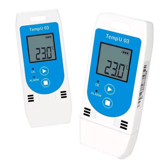
What is a Data Logger?
A Data Logger is an electronic device that records measurements over time at set intervals. It can include internal sensors, external probes, or both, depending on the application.
Common Parameters Measured:
Temperature and Humidity
Voltage and Current
Pressure and Air Quality
Light Intensity
Sound and Vibration Levels
The primary purpose of a Data Logger is to automate the process of data collection, making it more reliable, scalable, and accurate than manual methods. Most models are battery-powered and built to operate unattended in remote or sensitive environments.
Applications of Data Loggers:
Pharmaceutical Supply Chains: Monitoring temperature and humidity in vaccine transportation.
Agriculture: measuring the soil temperature and moisture to optimize irrigation.
Energy Audits: Logging power consumption in buildings and factories.
Environmental Research: Collecting long-term data for climate models.
At uniglobalbusiness, you’ll find a wide range of Data Loggers with USB, wireless, and cloud-enabled connectivity, allowing users to easily export and analyze data. Their compact form factor and rugged design make them ideal for both indoor labs and challenging outdoor environments.
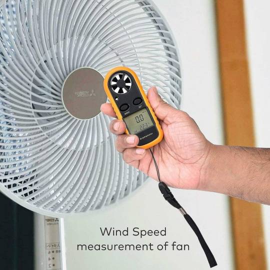
What is an Anemometer?
An Anemometer is a device that is used to measure wind speed, and in some models, wind direction. It is an essential tool in meteorology, aviation, construction, and renewable energy sectors.
Types of Anemometers:
Cup Anemometers: They use rotating cups to measure wind speed.
Vane Anemometers: It combines a wind vane and a propeller for direction and speed.
Ultrasonic Anemometers: Use sound waves to detect wind flow — ideal for high-accuracy applications.
Where Are Anemometers Used?
Wind Farms: Determine optimal locations for wind turbines.
Weather Stations: Provide data for forecasting and climate modeling.
Construction Sites: Ensuring crane and equipment safety in high-wind conditions.
Agriculture: Help with time pesticide spraying and irrigation based on wind speed.
uniglobalbusiness offers a reliable selection of portable and fixed Anemometers, suitable for both professional and academic use. Each model is chosen for durability, precision, and ease of calibration — essential traits for environments where wind data is mission-critical.
How Uniglobalbusiness Helps You Measure with Confidence
When it comes to instrumentation, reliability and service matter as much as specifications. That’s why industry professionals and researchers trust Uniglobalbusiness for their measurement needs.
Here’s what sets them apart:
Curated collections that balance affordability with performance
Products tested for industrial and academic standards
Ongoing support and transparent product information
By choosing tools from Uniglobalbusiness, you’re not just purchasing devices — you’re investing in a smoother workflow, better data accuracy, and long-term efficiency.
Final Thoughts: Why These Tools Matter Now More Than Ever
The shift toward smart, sustainable systems requires accurate environmental and operational data. Instruments like the Data Logger and Anemometer enable this shift by providing the real-time insights necessary to optimize performance, ensure safety, and support compliance.

CONTACT US
Uniglobal Business
Plot number 3 Office No : A22 ( 6th Floor) Wegmans Signature Tower Knowledge Park 3 Above Decathlon Greater Noida 201310
Email Us : [email protected]
Enquiry : +91–9278333555, 9312349595
Website:- https://uniglobalbusiness.com/
0 notes
Text
Agrivoltaic Farm Models
Agrivoltaics, the integration of solar photovoltaic (PV) systems with agricultural activities, is emerging as a promising solution to maximize land use efficiency while addressing global food and energy challenges.
Developing scale models of agrivoltaic farms plays a crucial role in optimizing designs, understanding environmental impacts, and refining management practices.
These scale models enable researchers, farmers, and policymakers to assess the feasibility and benefits of agrivoltaic systems before implementing them at full scale.

Importance of scale models in agrivoltaics
Scale models serve as experimental setups to study interactions between crops, solar panels, and environmental factors. They help in:
Optimizing Panel Arrangements: Different configurations, such as elevated panels, fixed-tilt arrays, or dynamic tracking systems, can be tested to determine the best design for sunlight penetration and crop yield.
Assessing Microclimatic Effects: Scale models allow researchers to monitor changes in temperature, humidity, and soil moisture under different agrivoltaic conditions.
Improving Water Use Efficiency: By understanding how shading from solar panels affects water retention, irrigation strategies can be improved for sustainable farming.
Testing Crop Compatibility: Various crop species can be studied to determine their adaptability to agrivoltaic conditions, ensuring maximum yield without compromising energy production.
Evaluating Energy Production: Scale models help in estimating the potential electricity generation from PV systems and their impact on farm operations.

Design and implementation of agrivoltaic scale models
Creating effective scale models involves several key considerations:
1. Selection of Site and Scale
The chosen site should resemble real farming conditions, and the scale must be appropriate for replicating real-world scenarios (e.g., 1:10 or 1:20 scale).
2. Miniaturized Photovoltaic Systems
Small-scale solar panels are installed to mimic full-sized agrivoltaic systems, with adjustable configurations to test different panel angles, spacing, and heights.
3. Choice of Crops
Crops typically grown in agrivoltaic farms, such as leafy greens, tomatoes, and berries, should be included in the model to study their response to partial shading and altered microclimatic conditions.
4. Environmental Monitoring Setup
Sensors and data loggers are integrated into the scale model to track parameters like sunlight exposure, soil moisture, temperature variations, and plant growth metrics.
5. Data Collection and Analysis
Regular data collection helps analyze the efficiency of different setups. Machine learning models and simulation software can be used to extrapolate findings to real-world applications.
Challenges and future directions
Despite their advantages, agrivoltaic scale models face certain challenges:
Scaling Limitations: While models provide insights, they may not fully capture large-scale interactions such as wind effects, pest control, and long-term soil health changes.
Cost of Model Development: Setting up and maintaining scale models requires investment in miniaturized solar panels, sensors, and monitoring equipment.
Technological Adaptability: The effectiveness of models depends on the ability to simulate real-world scenarios accurately, requiring continuous improvements in design and methodology.
Agrivoltaic farm scale models are essential tools for advancing the integration of solar energy with agriculture. They provide valuable insights into optimizing land use, improving food security, and enhancing renewable energy production.
Continued research and innovation in scale modeling will drive the adoption of agrivoltaic systems worldwide, promoting a more sustainable and resilient future for agriculture and energy sectors.
0 notes
Text
Power of a MATLAB-based data logger shines.
Monitoring agricultural field parameters has become crucial in optimizing crop health, water use, and overall farm productivity. Imagine having real-time data on soil moisture, temperature, and even water levels, all monitored and logged for you. This is where the power of a MATLAB-based data logger shines. By leveraging simple electronic components and sensors connected to Arduino, you can track…
0 notes
Text
Seismic Water Leak Detection in Perth
In Perth, Western Australia, the conservation of water is a crucial concern due to the region’s climate and increasing population pressures. Effective water leak detection has become essential to prevent wastage, manage costs, and maintain the water infrastructure that spans the city. Conventional leak detection techniques can be disruptive, slow, and sometimes not precise enough. As a result, advanced methods, such as seismic techniques, have been developed to detect leaks more accurately. This article examines the role of seismic technology in identifying water leaks, its benefits, and how it suits Perth’s unique landscape.

Why Water Leak Detection Is Critical in Perth
Perth's extensive network of water pipelines, servicing homes, businesses, and industrial zones, is vital for the region’s water management. Given the city’s dry climate and dependence on both groundwater and desalinated sources, protecting water supplies is a priority. Undetected leaks can result in:
High Water Waste: Even small leaks can lead to substantial water loss over time.
Infrastructure Risks: Leaks can cause soil erosion, increasing the risk of sinkholes and pipe failures.
Increased Costs: Water loss impacts operational costs and results in higher bills for consumers.
Environmental Strain: Wasteful water practices put pressure on natural resources and ecosystems.
Addressing these issues quickly is essential, and seismic detection provides an effective solution.
How Seismic Leak Detection Operates
What Is Seismic Detection?
Seismic technology uses specialised tools to sense vibrations and acoustic waves created by water leaking from pressurised pipes. These signals, though often beyond human perception, can be measured and analysed to pinpoint leak locations accurately.
How Seismic Signals Detect Leaks
When water leaks under pressure, it generates:
Sound Waves: The turbulent escape of water creates acoustic waves that move through the pipe and surrounding ground.
Vibrations: The mechanical force from the leak causes the pipeline and nearby earth to shake.
Unique Frequencies: Leaks create specific frequency patterns that can be isolated from other environmental sounds.
Special sensors collect these signals, allowing professionals to determine the exact source of a leak.
Seismic Leak Detection Process
Key Equipment Utilised
Geophones: Sensors that detect ground vibrations caused by leaks.
Hydrophones: Devices placed within water pipes to pick up acoustic waves inside the pipeline.
Accelerometers: Tools for measuring surface vibrations on pipes.
Data Loggers: Instruments that store the collected data for detailed analysis.
Software for Signal Analysis: This software processes the data to identify the presence of a leak.
Typical Steps in Seismic Leak Detection
Initial Review: Identify likely leak areas based on flow rates, pressure readings, or public reports.
Sensor Placement: Install sensors at strategic points along the pipeline.
Data Gathering: Capture vibration and sound data over a designated timeframe.
Analysis: Use advanced software to filter out irrelevant noise and focus on potential leak signals.
Leak Identification: Pinpoint the leak’s location using techniques like cross-correlation.
Confirmation: Conduct further inspections or apply additional methods if necessary.
Repair Strategy: Formulate a plan to repair the leak with minimal disturbance.
Benefits of Seismic Leak Detection for Perth
High Accuracy and Sensitivity
Precise Leak Location: This technology can identify leaks within a narrow range, reducing excavation and repair efforts.
Early Leak Detection: Sensitive sensors detect small leaks before they escalate.
Minimal Disruption
Low Impact: There’s no need for large-scale digging or invasive checks, protecting the landscape and minimising inconvenience.
Adaptable to Different Environments: This method suits urban, suburban, and rural locations, aligning with Perth’s diverse settings.
Cost Savings
Reduced Water Loss: Early identification prevents unnecessary water loss.
Lower Repair Costs: Targeted repairs are less costly than addressing major issues later.
Longer Infrastructure Life: Early leak detection reduces the stress on pipes, extending their service life.
Environmental Gains
Water Conservation: This method aligns with Perth’s water-saving goals, protecting resources for the future.
Lower Energy Use: Less water pumping and treatment are needed when water loss is minimised.
Overcoming Challenges with Seismic Techniques
Noise Pollution
Issue: Urban areas produce background noise from traffic and construction, which can obscure leak signals.
Solution:
Use advanced filtering software to eliminate unrelated noise.
Conduct surveys during quieter periods like nighttime.
Calibrate sensors to fine-tune focus on leak indicators.
Soil Characteristics
Issue: Perth’s sandy soils and moisture variations can influence how seismic waves travel.
Solution:
Adjust sensor depth and positioning based on the soil type.
Use local expertise to better interpret data considering regional soil conditions.
Applications of Seismic Techniques in Perth
Domestic Areas: Seismic methods have successfully found leaks in older water systems, preventing damage to roads and ensuring a reliable supply.
Commercial and Industrial Locations: In critical areas, such as healthcare facilities, early detection has maintained uninterrupted water services.
Extended Pipelines: For long-distance pipelines, seismic technology provides continuous monitoring of pipeline integrity.
Looking Ahead in Perth
The adoption of seismic leak detection is expected to increase as water utilities and private firms in Perth recognise its advantages. Ongoing research, possibly in partnership with local institutions, could enhance the technology’s effectiveness and further support Perth’s efforts to manage water efficiently.
Conclusion
Seismic detection offers a sophisticated, efficient, and non-invasive solution for water leak identification in Perth. Utilising this technology not only addresses water conservation challenges but also supports infrastructure sustainability. With its focus on precise and early detection, seismic techniques contribute to Perth’s goal of securing a stable and resilient water supply for future generations.
0 notes
Text
Soil moisture data logger are essential tools in agriculture, environmental science, and various engineering applications, providing crucial data for optimizing water usage and enhancing crop yield.
0 notes
Text
Monitoring and Inspection Methods for Reinforced Soil Slopes

Reinforced Soil Slopes (RSS) are an essential component of modern geotechnical engineering, providing stability and support in various construction projects, including highways, railways, and urban developments. Ensuring the long-term stability and safety of these structures requires regular monitoring and inspection. Effective monitoring and inspection methods are crucial to identify potential issues early and to maintain the integrity of the slopes. This article explores the key methods used for monitoring and inspecting reinforced soil slopes.
Importance of Monitoring and Inspection Monitoring and inspection of reinforced soil slopes are vital for several reasons. Firstly, they help in the early detection of potential failures or deformations, allowing for timely intervention. Secondly, they ensure compliance with design specifications and performance standards. Lastly, regular monitoring contributes to the safety of the infrastructure and the surrounding environment by preventing catastrophic failures.
Visual Inspections Visual inspection is the most straightforward and widely used method for monitoring reinforced soil slopes. This involves regular site visits by trained engineers who visually assess the slope for signs of distress, such as cracks, surface erosion, or unusual vegetation growth. Visual inspections are cost-effective and provide immediate information about the condition of the slope. However, they may not always detect underlying issues that are not visible on the surface.
Inclinometers Inclinometers are devices used to measure the angle of slope movement and deformation over time. These instruments are installed in boreholes along the slope and provide continuous data on the lateral movements within the slope. By monitoring these movements, engineers can detect any shifts or trends that might indicate instability. Inclinometers are particularly useful for slopes that are suspected to be at risk of failure due to lateral movements.
Piezometers Piezometers measure the pore water pressure within the soil, which is a critical factor in slope stability. High pore water pressure can reduce the shear strength of the soil, leading to slope failure. By monitoring the pore water pressure, engineers can assess the effectiveness of drainage systems and detect any changes that might threaten the stability of the reinforced soil slopes. Piezometers can be installed at various depths to provide a comprehensive understanding of the subsurface water conditions.
Settlement Gauges Settlement gauges are used to measure the vertical displacement or settlement of the soil. These gauges can detect any subsidence or heave in the slope, which could indicate potential stability issues. By monitoring vertical movements, engineers can ensure that the reinforced soil slopes are performing as expected and take corrective actions if necessary.
Geotechnical Instrumentation and Remote Sensing Advanced geotechnical instrumentation, such as extensometers and strain gauges, can provide detailed information on the deformation and stress within the soil. These instruments are installed within the slope and connected to data loggers, which record the measurements over time. Remote sensing techniques, such as LiDAR (Light Detection and Ranging) and UAV (Unmanned Aerial Vehicle) surveys, can also be employed to monitor large areas efficiently. These technologies allow for the collection of high-resolution data and can identify changes in the slope that might not be visible to the naked eye.
Ground Penetrating Radar (GPR) Ground Penetrating Radar is a non-invasive method used to detect subsurface anomalies and changes in soil composition. GPR can identify voids, changes in soil density, and other factors that might affect the stability of reinforced soil slopes. By using GPR, engineers can gain insights into the internal structure of the slope and detect potential issues before they become critical.
Data Analysis and Interpretation The data collected from various monitoring instruments must be analyzed and interpreted by geotechnical engineers to assess the stability of the reinforced soil slopes. This involves comparing the measured data with design specifications and historical performance data. Advanced software tools can assist in analyzing the data and predicting future behavior of the slopes. Regular reporting and documentation of the monitoring results are essential for maintaining a comprehensive understanding of the slope's condition over time.
Conclusion Monitoring and inspection of reinforced soil slopes are crucial for ensuring their long-term stability and safety. A combination of visual inspections, inclinometers, piezometers, settlement gauges, geotechnical instrumentation, remote sensing, and Ground Penetrating Radar provides a comprehensive approach to monitoring these structures. By employing these methods, engineers can detect potential issues early, maintain compliance with design standards, and ensure the safety of the infrastructure and the surrounding environment. Effective monitoring and inspection not only extend the lifespan of reinforced soil slopes but also contribute to the overall reliability and resilience of modern construction projects.
0 notes
Text
Mengetahui Kemampuan Tanah Dalam Menghantarkan Arus Listrik.
Tanah adalah salah satu komponen vital dalam ekosistem yang memengaruhi pertumbuhan tanaman, kesehatan lingkungan, dan berbagai aspek kehidupan.
Salah satu parameter penting yang digunakan untuk memahami sifat dan kualitas tanah adalah konduktivitas listrik tanah, atau yang dikenal sebagai Soil Electrical Conductivity (SEC).
Soil Electrical Conductivity (SEC) data logger adalah perangkat elektronik yang dirancang khusus untuk memantau dan merekam tingkat konduktivitas listrik tanah secara kontinu.
Perangkat ini biasanya terdiri dari probe atau sensor yang ditanam di dalam tanah untuk mengukur konduktivitas listrik di lokasi tertentu. . Baca selengkapnya di : https://www.loggerindo.com/mengetahui-kemampuan-tanah-dalam-menghantarkan-arus-listrik-484 . . Ingin tau lebih lanjut? atau ingin bertanya? Silahkan hubungi kami melalui :
Whatsapp : 0812 1248 2471 (Mr. Alfin) / 0819 4401 4959 (Mr. Arya)
Email : [email protected] / [email protected]
Website : loggerindo.co.id / loggerindo.com
#SoilConductivity#TanahDanArusListrik#SoilElectricity#KonduktivitasTanah#SoilProperties#SoilScience#KemampuanTanah#SoilTesting#TanahDanKelistrikan#KualitasTanah#PemantauanTanah#KonservasiTanah#KesehatanTanah#AgroTeknologi#PertanianBerkelanjutan#BerkahTanah#EkologiTanah#TanahDanLingkungan#PertanianMasaDepan
0 notes
Text
Automatic Weather Station
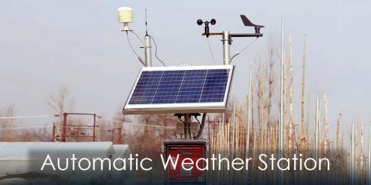
Automatic Weather Station: Our everyday life, which includes agriculture and transportation, may affected by the weather as weather is not only dynamic but also powerful force. Accuracy is an important thing in all the fields. Correct weather monitoring, as well as forecasting, are very important factors in order to make weather-related decisions and reduce the risks that are connected with the weather. This device has ability to collect the data and observe that data at the current time. Automatic weather stations (AWS) have different kinds of tools and all these instruments are highly effective for weather monitoring which always provide accurate results according to the requirement. We’ll explore the features, elements, advantages, and use of Automatic Weather Stations (AWS). Moreover, how it helps with weather forecasting and environmental monitoring.
What is an Automatic Weather Station?
Automatic Weather Station (AWS) is a highly advanced meteorological tool that is designed to measure the different kinds of atmospheric parameters automatically. These parameters contain multiple factors some of the features include temperature, pressure, humidity, the direction of the wind, speed, and precipitation. Occasionally, they also include additional environmental factors which include solar radiation and soil moisture. As this is fully automatic there is no need for human interference. Automatic Weather Station (AWS) functions independently, collecting the data and sending the data or information.
How Does an Automatic Weather Station Work?
Automatic Weather Stations (AWS) work independently as well as automatically and consist of multiple connected components these components may include, data loggers, communication systems, sensors, and power sources. All components have different kinds of work according to their name first and foremost is the sensor so the work of the sensor is to measure the parameters of the atmosphere, in order to process the data and store that data this is the working of data loggers. A communication system as the name implies transfers information or data to a database or user interface, allowing current-time analysis and observation. Working in remote locations can be possible only because of power sources such as batteries or solar panels.
Components of an Automatic Weather Station:
This Automatic Weather Station (AWS) depends upon many types of components and these components help to enhance the overall performance. The working of these components are pre-defined which helps to perform the task.
Sensors
One of the most important elements in Automatic Weather Station (AWS) is sensors, which help to observe a range of atmospheric factors. There are some common sensors that are very useful these are Anemometers (wind speed sensors), wind vanes (wind direction sensors), temperature sensors (thermometers), humidity sensors (hygrometers), pressure sensors (barometers), and rain gauges (precipitation sensors). Moreover, these sensors are helpful for detecting solar radiation, soil moisture, and air composition and might be included in some of the advanced Automatic Weather Stations.
Data Loggers
Storing and recording the data is also important in Automatic Weather Stations so the data is stored and recorded by the data loggers, which are electrical devices. Automatic Weather Stations have to store large amount of data so the devices frequently have internal memory or storage that is able to hold large amount of data. In order to data processing and analyzing, programmable logic controllers (PLCs) or Microcontrollers may be included in the data loggers.
Communication Systems
with the help of a communication system, these allow meteorological data to be transferred from Automatic Weather Stations (AWS) to a database or user interface. In today’s modern time, most devices are wireless which is used by most people so some most common communication systems may include cellular networks, satellite communication, Wi-Fi, and radio frequency (RF) transmission. Meteorologists and researchers not only remotely monitor weather conditions but also make quick judgments this can be possible only because of current time data transmission.
Power Sources
All components require energy so this is the reasonability for the Power sources which supply energy to the Automatic Weather Station’s components, so that all operations can be done on time. When deploying Automatic Weather Stations (AWS) in isolated or off-grid areas, solar energy is typically captured using solar panels. Systems with battery backups supply extra power when there is little sunlight or bad weather.
Advantages of Automatic Weather Stations
There are some advantages of automatic weather stations which is really helpful so these advantages are mentioned below:
Real-time Data Collection
Only because of Automatic Weather Station’s (AWS) current time weather data by which Meteorologists can continuously monitor atmospheric conditions.
High Accuracy and Precision
Accuracy is the most important thing in all the fields so the same in Automatic Weather Stations correct as well as exact measurements of air parameters is possible by complex sensors and calibration procedures. Which always provides correct data all the time which is beneficial for other processes.
Automatic Operation
As Automatic Weather Stations (AWS) is fully automatic which do ‘not require any kind of human activity and AWS works independently that is why it requires less maintenance and less human involvement. Because is it fully automatic it provides accurate output and works very fast.
Remote Monitoring
The remote monitoring feature of AWS makes it unique and effective. Remotely monitoring can be possible only because of Automatic Weather Stations (AWS) by which weather can be monitored at any location in the whole world. AWS has capabilities of wireless networking which do ‘not require any kind of wire connection.
Cost-effectiveness
This is the most crucial factor which matters a lot in all the fields. Manual weather stations require high operating cost but on the other side, Automatic Weather Stations (AWS) do not require operating expenses and require less personnel than manual weather stations. It is more cost-effective not only in the long run but also in initial setup costs.
Flexibility
Automatic Weather Stations (AWS) are fully flexible as extreme weather, remote regions, and towns are just a few of the settings in which AWS can be used.
Places Where Automatic Weather Stations are Used
There are some places where Automatic Weather Stations (AWS) can be used. These places are mentioned below:
Meteorological observatories
In order to monitor the weather conditions and offer perfect forecasts, national meteorological agencies install AWS at meteorological observatories. So that all kinds of operations can be done.
Agricultural Applications
In today’s digital time, even farmers use Automatic Weather Stations (AWS) in order to take educated decisions about irrigation, crop management, and pest control by using AWS to monitor weather conditions in their fields.
Transportation Infrastructure
Critical weather information is also provided by the Automatic Weather Stations (AWS) installations near highways, airports, and ports, ensuring safe and effective transportation operations.
Environmental Research
AWS is also helpful for scientists as scientists use it to investigate how weather patterns and climate change affect natural resources, ecosystems, and biodiversity.
Industrial Facilities
Automatic Weather Stations (AWS) are also helpful for the security purposes. To guarantee security and maximize efficiency, sectors including manufacturing, energy, and construction use Automatic Weather Stations(AWS) for weather monitoring.
Educational Institutions
AWS is also useful in the education field for teaching as well as for research, educational institutions give practical experience to students in meteorology and environmental science.
Contributions to Environmental Monitoring and Weather Forecasting
By supplying correct and fast weather data, automatic weather stations are essential to environmental monitoring and weather forecasting. These details are necessary for a number of applications, such as:
Environmental Impact Assessment
By analyzing AWS data, one may evaluate how human activities—like industrial pollutants, deforestation, and urbanization—affect the environment.
Early Warning Systems for Natural Catastrophes
Amazon’s real-time weather data allows for early warning systems for natural catastrophes like hurricanes, tornadoes, floods, and wildfires.
Climate Research
By examining trends, patterns, and anomalies in weather and climate variables, long-term weather data gathered by AWS aid in the study of climate change.
Resource Management
Sustainable resource management techniques, such as water resource management, forest conservation, and wildlife preservation, are supported by meteorological data from AWS.
Weather Modeling
By incorporating AWS data into numerical weather prediction models, weather predictions become more accurate and dependable, which lessens the impact of extreme weather events.
Lightning Detection Guide:
Certain advanced AWS come with lightning detection systems in addition to standard meteorological parameters. These devices track and identify lightning strikes in real time using specialized sensors and algorithms. Information from lightning detection is useful for:
Public Safety
By enabling prompt public warnings, lightning detection lowers the possibility of lightning-related accidents resulting in harm or death.
Aviation Safety
Pilots can steer clear of thunderstorms and turbulence-prone areas by using lightning detection, which is essential for aviation safety.
Outdoor Activities
The ability to detect lightning aids in the decision-making process for outdoor enthusiasts, sports organizers, and event planners.
GLOBE Program
A multinational science and education program called Global Learning and Observations to Benefit the Environment (GLOBE) Program invites students and citizen scientists to participate in environmental monitoring projects. Because it gives students practical experience in weather observation and data collecting, AWS is essential to the GLOBE Program. Students are taught the value of environmental stewardship, international cooperation, and weather monitoring in tackling environmental issues through the GLOBE Program.
Conclusion
The Automatic Weather Stations (AWS) is very useful in various fields and most of the most important factors of AWS, are it’s cost-effective and also very easy to use, and can be understood by everyone. In order to comprehend and lessen the effects of weather-related catastrophes on people and the environment, Amazon continues to play a critical role. Amazon Web Services (AWS) will continue to be a vital resource for tracking Earth’s climate and environment as we work toward a more sustainable future.
0 notes
Text
Step-by-Step Comprehensive Guide to Observation Wells
Observation wells are instrumental in monitoring groundwater, offering crucial insights into water levels, quality, and environmental conditions. This step-by-step guide provides a comprehensive overview of the process involved in creating observation wells, ensuring accurate data collection for effective groundwater management.
Step 1: Preliminary Assessment
Before diving into the drilling process, conduct a thorough preliminary assessment. This involves understanding the hydrogeological characteristics of the area, including soil types, geological formations, and potential sources of contamination. Identify key parameters to be monitored and establish the goals of the observation well project.
Step 2: Site Selection
Selecting the right location is paramount to the success of observation wells. Utilize information from the preliminary assessment to identify suitable sites based on aquifer characteristics and accessibility. Consider factors such as land use, proximity to potential contaminant sources, and the geological setting.
Step 3: Planning and Design
Develop a detailed plan for the observation well project. Outline the drilling depths, materials to be used, and the monitoring frequency. Incorporate a timeline that includes drilling, equipment installation, calibration, and ongoing maintenance. Collaborate with hydrogeologists and drilling professionals during the planning phase.
Step 4: Drilling Operations
Engage drilling professionals with experience in groundwater projects to execute the drilling operations. Common methods include rotary drilling, auger drilling, or direct-push technology. Install casing materials, such as PVC or steel, to prevent well collapse and maintain stability.
Step 5: Installation of Monitoring Equipment
After drilling, it's time to install monitoring equipment. Place sensors at different depths within the well to measure critical parameters like water levels, temperature, and conductivity. Install a data logger to record this information at regular intervals. Ensure proper sealing of the well to prevent surface water infiltration.
Step 6: Calibration and Testing
Calibrate the monitoring equipment to ensure accurate measurements. Compare sensor readings with known standards to validate their accuracy. Conduct controlled purging or pumping tests to assess the response of the well to changes in water levels and quality. Document the results and make any necessary adjustments to the monitoring equipment.
Step 7: Data Collection and Management
Once the observation well is operational, it begins generating a continuous stream of data. Implement an automated data collection system to record information at predetermined intervals. Establish a robust data management system to organize and analyze the collected data effectively.
Step 8: Regular Maintenance
Regular maintenance is essential to the longevity and accuracy of observation wells. Conduct routine inspections to check for any signs of damage, corrosion, or malfunctioning equipment. Address issues promptly to prevent interruptions in data collection.
Step 9: Integration into Groundwater Management Plans
Integrate the data obtained from observation wells into broader groundwater management plans. Collaborate with local authorities, environmental agencies, and water management organizations to use the information for informed decision-making. Adjust management strategies based on the insights gained from continuous monitoring.
Step 10: Public Outreach and Education
Engage in public outreach and education initiatives to raise awareness about the importance of observation wells in groundwater monitoring. Foster community involvement and understanding to create a collective commitment to responsible water management practices.
Conclusion:
Creating observation wells involves a systematic approach that combines scientific knowledge, engineering expertise, and ongoing dedication. By following this step-by-step guide, stakeholders can establish effective observation wells that contribute significantly to the sustainable management of groundwater resources. These wells serve as critical tools in safeguarding water quality, preserving ecosystems, and ensuring a resilient water supply for communities.

1 note
·
View note