#Southeast Colorado Plateau
Video

flickr
Exploring Mesa Verde National Park with a Park Ranger Guide by Mark Stevens
Via Flickr:
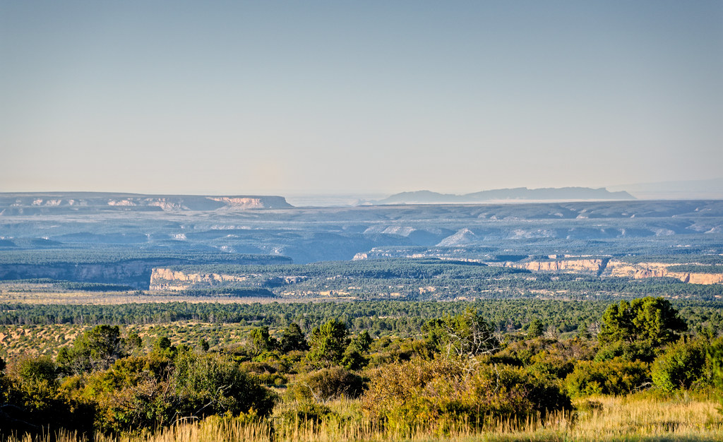
While at the Soda Canyon Overlook with a view looking to the south-southwest to the Balcony House in Mesa Verde National Park. Which drew me into this image and setting was the park ranger lead tour of this dwelling. I wanted to capture that view of the park ranger giving information to the group in the tour while pulling back on the focal ;length to include the entirety of this national park setting. From where I was located to the Balcony House, I measured on Google Maps as being about a quarter mile.
#Azimuth 192#Balcony House#Day 6#Looking SSW#Mesa Verde National Park#New Mexico and Mesa Verde National Park#Nikon D850#Soda Canyon Overlook Trail#DxO PhotoLab 7 Edited#Landscape#Landscape - Scenery#Nature#Outside#Scenics - Nature#SnapBridge#Travel#Colorado Plateau#Intermountain West#Rocky Mountains#Southeast Colorado Plateau#Ute Mountain Area#Partly Sunny#Sunny#Colorado#United States#flickr
2 notes
·
View notes
Photo
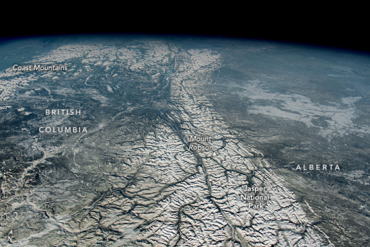
Canadian Rockies While orbiting over western Montana, an astronaut aboard the International Space Station captured this photograph of the northern Rocky Mountains, also known as the Canadian Rockies. Sprawling approximately 4,800 kilometers (3,000 miles) long and nearly 650 kilometers (400 miles) wide at certain points, the Rockies are North America’s largest mountain range. The Rocky Mountains extend from British Columbia, Canada, southeast toward New Mexico, in the United States. At least 100 separate ranges comprise the Rockies, and they are separated into four geologic subdivisions: the Canadian and Northern Rockies, Middle Rockies, the Southern Rockies, and the Colorado Plateau. This image features the greater portion of the Canadian Rockies, which extends through northern British Columbia and southwestern Alberta. While there are approximately 50 peaks in the Canadian Rockies surpassing 3,350 meters (11,000 feet) in elevation, Mount Robson—in the center of the photo—is the highest peak at about 3,950 meters (12,970 feet) tall. Jasper National Park, in Alberta, encompasses around 11,214 square kilometers (4,330 square miles) of mountainous terrain, glaciers, forests, and alpine landscapes. The park was established in 1907 and is one of several contiguous parks in the Canadian Rockies that have been recognized as a UNESCO World Heritage Site. The park also supports a vast diversity of wildlife. There are 53 different types of mammals found in the park including bears (both black and grizzly), wolves, elk, and cougars. Part of the Coast Mountains, a major range along the Pacific coastline of British Columbia and Alaska, is visible in the upper-left part of the image. Glaciers carved out numerous valleys along the 1,600-kilometer (990-mile) long range, including several fjords along British Columbia’s Pacific coast. Astronaut photograph ISS068-E-31571 was acquired on December 21, 2022, with a Nikon D5 digital camera using a focal length of 50 millimeters. It is provided by the ISS Crew Earth Observations Facility and the Earth Science and Remote Sensing Unit, Johnson Space Center. The image was taken by a member of the Expedition 68 crew. The image has been cropped and enhanced to improve contrast, and lens artifacts have been removed. The International Space Station Program supports the laboratory as part of the ISS National Lab to help astronauts take pictures of Earth that will be of the greatest value to scientists and the public, and to make those images freely available on the Internet. Additional images taken by astronauts and cosmonauts can be viewed at the NASA/JSC Gateway to Astronaut Photography of Earth. Caption by Minna Adel Rubio, GeoControl Systems, JETS Contract at NASA-JSC.
2 notes
·
View notes
Photo


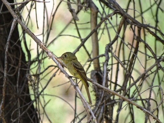
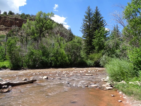


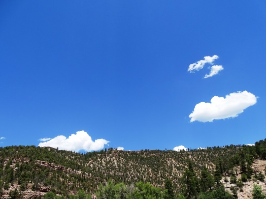
San Miguel County, CO (No. 1)
The San Miguel River is a tributary of the Dolores River, approximately 81 miles (130 km) long, in southwestern Colorado in the United States. It rises in the San Juan Mountains southeast of Telluride and flows northwest, along the southern slope of the Uncompahgre Plateau, past the towns of Placerville and Nucla and joins the Dolores in western Montrose County approximately 15 miles (24 km) east of the state line with Utah.
The San Miguel is more or less free-flowing; however, diversion dams dot the river and alter flows. In some parts it is however one of the few remaining naturally functioning rivers of the West.
The San Miguel varies in gradient, from extremely steep in its upper reaches (forming a shallow, rocky, unnavigable stream) to more mellow in the lower sections (30–50 feet per mile (5.7–9.5 m/km) of drop, which offers the whitewater boater a variety of runs all within the class II+--III range). All told, the San Miguel drops over 7,000 feet (2,100 m) from an alpine ecosystem to the desert. The average flow is about 600 cu ft/s (17 m3/s).
Source: Wikipedia
#Norwood#San Miguel County#San Miguel River#San Juan Mountains#USA#Rocky Mountains#river bank#red soil#flora#forest#woods#tree#bird#wildflife#animal#Cordilleran flycatcher#blue sky#clouds#landscape#countryside#original photography#tourist attraction#landmark#Mountain West Region#Colorado#fir#pine
2 notes
·
View notes
Photo

June 21st is...
Arizona Day - Arizona became a state on Valentine’s Day in 1912. Arizona is home to the oldest continuously inhabited settlement in North America. Established around 1000 A.D., the village of Old Oraibi is located on the Hopi Indian Reservation in Navajo county. Known as the Grand Canyon State, Arizona brings the wilderness to you. The breathtaking views of the Colorado Plateau, which incidentally took over 70 million years to form into towering stone, are now one of nature’s grand centerpieces.
Day Of The Gong - Mighty and gentle, earthy, and celestial, this extraordinary instrument is a conduit of Creation. With an international cultural history, the gong offers sensory and multi-dimensional sounds. Thanks to artisans worldwide, gongs come in an array of sizes, designs, and origins. As an instrument, they are both beautiful in design and performance. While gongs originate in the East or Southeast Asia, they also have an ancient history in Rome.
Daylight Appreciation Day - It recognizes the summer solstice (the longest day of daylight in the northern hemisphere) and encourages people to celebrate the many benefits of the sun.The day also offers an opportunity to learn more about the importance of daylighting. Daylighting is using skylights, windows, and other architectural openings to naturally light interior spaces. Doing so helps not only to reduce energy consumption but may also have health benefits.
Go Skateboarding Day - Retailers, sponsors, parks, and individuals around the world host events showcasing this rebellious and creative culture. A combination of athleticism, dance, and art, skateboarding has grown up in an urban world. It also crosses multicultural divides and speaks to a diverse population. Skaters test the laws of gravity with a variety of ariels and twists, thrilling their fans.
Indigenous Peoples Day - It’s all about bringing people together from different walks of life to share in the contributions of Indigenous People to our society. You’ll find an eclectic mix of contemporary and traditional music while learning about how Indigenous Peoples helped to develop our agriculture, language and social customs. The day is also about how governments are creating crucial partnerships with Indigenous Peoples to protect their land, heritage and culture in modern times.
International Yoga Day - One of the best and oldest ways to release the tension building up in both the body and the mind is practicing yoga. The benefits of practicing yoga, such as mastering countless techniques of controlling the body and the mind, have been widely recognized by the Western world for years, and International Yoga Day aims to continue to inform people how much dedicating a bit of time to the art of yoga can improve their lives. It is not just a physical practice, but also a mental one, with many of the teachings of yoga reflecting mental and spiritual states, and allowing your body to wander and drift into unknown realms that will give you a focus in your life and a calmness with your soul.
Peaches ‘n Cream Day - Peaches’ n’ Cream is a simple, traditional, and delicious summertime dessert. Make some homemade vanilla ice cream to sweeten the deal, and your peaches’ n’ cream will be all the cooler
Selfie Day - While the act of taking a selfie may predate social media, smartphones, and the word itself (which is now in the Oxford Dictionary), the popularity of taking these self-portraits keeps increasing. And the ability to take them gets easier all the time. Selfie sticks and multi-functional camera phones make it all too convenient to take these kinds of photographs as well as group selfies (aka groupies).
World Giraffe Day - Whether you’re into conserving their native habitats, enjoy hanging out with our necky friends at the zoo or you just appreciate the joy of nature’s most weird and wonderful creatures, World Giraffe Day is a day of observance when you can really put your neck out!
World Humanist Day - There is a philosophy of belief that indicates that humanity is more than just the puppets of some divine being or subject to a list of metaphysical oddities and creatures with their own designs. Instead, humanism believes that we are whole in and of ourselves and that our good behavior and civility is not reliant on anything except a true and honest desire to be decent people. Most of all this philosophy raises the importance of personal responsibility, if we behave as monsters, it is we who are monsters, there is no ���The Devil Made Me Do It”. World Humanist Day celebrates this ideology and those who practice it, bringing reason and science to the world of faith and irrationality.
World Motorcycle Day - Today motorcycles are used for an increasing number of applications, including delivery driving, passenger conveyance, recreation, and even just daily commuting. This is due, in no small part, to the incredible gas mileage these vehicles get, and how compact and easy they are to store even if you live in an apartment. Whether you’re using your motorcycle to get around from day to day, or are an enthusiast or hobbyist who goes on long rides as part of your yearly vacation, World Motorcycle Day is for you.
World Music Day - Music has existed for as long as mankind has found its voice, and quite possibly before. Every culture of the world has its own form of music, as distinct and unique to its area as language and cuisine. In the western world, we are familiar only with scales, known as the diatonic scale which should be familiar to anyone who took music classes or choir in school. But this is not the only or even the first scale that music can use. There’s the chromatic scale, which has 12 notes instead of the 7, and the octatonic scale, which has 8 notes, but these are just the beginning. In every part of the world, there are different scales and musical formats used, and these create a form of music that has its own signature. Then when you add in the cultural themes, the variety of instruments, and the forms of voice singing that can go along with it, music is a truly endless adventure. World Music Day celebrates this adventure and those that dare to take it.
#arizona#gong#daylight#skateboard#indegenous people#yoga#peaches n cream#selfie#giraffe#Humanist#motorcycle#music
16 notes
·
View notes
Note
Hi, your blog is great, a very good resource and useful. I was wondering if I could ask, have you ever read a book/article about the life cycle of product, I mean an examination of the resource extraction/labor/factory/transport process and how each stage is damaging to people/environment? I've been looking and nothing is useful. Sorry if my English is not great. Thank you for your blog!
Hello. Thank you for such a supportive and kind message. You are always welcome to send me messages. I know that I’m often annoying, so I’m happy if anything I’ve shared/posted has provided an interesting resource.
Thank you for trusting me enough to send me this message, but I don’t think I’m qualified to answer it too well. I think that some of my friends on this site would be better able to provide some recommendations for you. For example, I don’t know anything about the transportation stage of products, or how providers/corporations eventually come to move, say, edible produce from the agricultural source, across borders, and into a grocery store (though I’m mostly-sure that colonial/imperial/corporate powers have obscured these mechanisms of food production, in many/most cases purposely, in order to absolve metropolitan consumers of any potential realization of guilt or complicity in violence). But I don’t know anything about product life cycles generally. So I don’t think I’m a great person to ask, y’know? For example, in the case of, say, lithium production, I’ve not found or read any, like, comprehensive book or singular text that, like, follows the entire process from extraction, through refinement, to use, and then eventual disposal. But I’m sure there are books/articles/texts out there which do describe this process. And that’s why I’d invite someone else, one of my friends or whomstever, to offer recommendations, since I can’t.
------------
That said, I’ve got a couple of recommendations. I’m relatively more interested in plantations; the life cycle of some few very specific products (rubber; palm oil; uranium; lithium); more broad discussion of the damage wrought from industrial-scale resource extraction and development (Anthropocene and Plantationocene concepts; planetary urbanization); or the violence of the first/initial stages of the product life cycle (wastelanding; colonial/imperial institutions dispossessing people of land; poisoning/contamination from mining). So I’ve got some resources here related to these concepts.
------------
The concept of “planetary urbanization” or “planetary urban fabric” basically refers to how, at least in the past two or three centuries, there is no corner of the planet that has been spared ecological damage by or escaped the resource extraction cycles of industrial development and major urban areas. This is the idea that every corner of Earth, no matter how apparently “remote” or “wild”, is altered by and implicated in industrial resource extraction. (For example, even “remote” Siberia hosts pipelines and giant mines that service major urban areas. Ice-loss in Greenland and algae blooms in the open ocean are related to anthropogenic climate alteration. Isolated forests of the Great Bear Rainforerst are still penetrated by logging roads. Industrial cropland disrupts the soil of the West African Sahel, and then Saharan dust storms sweep into the Caribbean; etc.)
Some introductions to the concept: Roi Salgueiro Barrio. “What World? Reframing the World as One City.” December 2016. ////////// Lindsay Bremner. “The Urban Hyperobject.” Geoarchitecture. 24 August 2015. ////////// Maria Kaika and Erik Swyngedouw. “Radical urban political-ecological imaginaries.” Derive. May 2014. ////////// And here’s a compilation post I put together, with short excerpts from several articles about planetary urbanization.
------------
Anyway, seems like this might be more closely related to what you’re looking for. These are some recent things I’ve read that seem related to the violence of the product life cycle.
-- I wrote a post about the violence of the life cycle of uranium (including initial extraction and mining; refinement; and disposal, imposing violence at every stage of production) in Navajo Country and the Colorado Plateau (includes maps of uranium mines; radioactive fallout zones; and radioactive waste disposal sites).
-- Andrea Knutsen. “Scarcity and the Suburban Backyard.” Edge Effects. 1 September 2020. [This article is about food and grocery store supply chains in North America during crises and how British imperialism in the Caribbean in recent centuries relied on the imposition of artificial scarcity and the maintinence of a racialized economic hierarchy which still influences contemporary food supply chains.]
-- Gaston Gordillo. “The Metropolis: The Infrastructure of the Anthropocene.” In: Infrastructures, Environment, and Life in the Anthropocene. Edited by Kregg Hetherington. 2019. [This article is about the stages of dispossession, policy, and marketing that support massive soy agriculture/extraction in Latin America, and how soy is an example of how contemporary products involve dispossession at multiple scales in multiple regions driven by forces that transcend national boundaries. This article also describes planetary urbanization.]
-- Martin Arboleda. “Financialization, totality, and planetary urbanization in the Chilean Andes.” December 2015. [This article is about lithium in Latin America, how lithium extraction relates to the mass “financialization of life” in the neoliberal era, and how local dispossession in Chile is driven by investors and companies from North America.]
-- Yanis Iqbal. “The Ravages of Lithium Extraction in Chile.” 15 July 2020. [This article is about “lithium imperialism” and how so-called “sustainable” electric cars in European and North American markets rely on dispossession and ecological/human violence in Latin America.]
-- Gregg Mitman. “Forgotten Paths of Empire: Ecology, Disease, and Commerce in the Making of Liberia’s Plantation Economy.” Environmental History. December 2016. [Article about the early-20th-century extraction and production of rubber via corporate plantations in West Africa and how US medical institutions and Harvard doctors relied on plantations for access to research; also discusses coffee and fruit plantations in Latin America.]
-- Post I wrote about the difference between a forest and a tree plantation, focused on resource extraction on Mapuche land in the Valdivian temperate rainforest region of “Chile.”
-- Mongabay has done consistent work covering palm oil plantations which service European and North American food markets, especially focused on plantations in Indonesia, which appear to be dependent on Indigenous dispossession in Borneo and Papua. One example of the initial stages of violence: Sophie Chao. “In the plantations there is hunger and loneliness: The cultural dimensions of food insecurity in Papua.” Mongabay 14 July 2020.
-- On a related note, here’s a long and comprehensive look at palm oil: Human Rights Watch. “When We Lost the Forest, We Lost Everything”: Oil Palm Plantations and Rights Violations in Indonesia. September 2019.
-- Melanie K. Yazzie. “Decolonizing Development in Dine Bikeyah: Resource Extraction, Anti-Capitalism, and Relational Futures.” Environment and Society. September 2018. [This article is about the connections between Navajo Country and US border policies; connections between coal mining, uranium, and land dispossession; and ecological/human damage of wastelanding in the region.]
-- Post I wrote about fossil fuel refineries; environmental racism; high c0vid death rates; cancer rates; toxic air; state violence; and local zoning policy in Louisiana’s Cancer Alley (with a bunch of maps, photos, and graphics).
-- Inspired by a good article Mongabay did about the history of one particular major land-owning company, here’s a post I wrote about how a Gilded Age company founded by friends of King Leopold in the infamous rubber plantations of the Congo eventually came, today, to establish and own the major rubber plantations of Southeast Asia which service Euro-American markets, while the same company still maintains many “neo-colonial” land holdings in Africa.
-- Nicholas Jahr. “Workers Organize at Firestone, Liberia’s ‘State Within a State’.” The Nation. 8 July 2010. [Article about contemporary rubber plantations in West Africa and how Firestone -- “official tire of Major League Baseball” -- functions and rules as a de facto colonial/imperial state.]
-------
Let me know if anyone wants links to read these articles for free.
Thank you for reaching out. Thanks again for being so kind.
24 notes
·
View notes
Photo

📷Featured Photographer📷 @just.shoot.this - The Rio Grande Gorge is a geological feature in northern New Mexico where the Rio Grande follows a tectonic chasm. Beginning near the Colorado border, the approximately 50-mile gorge runs from northwest to southeast of Taos, New Mexico, through the basalt flows of the Taos Plateau volcanic field. The Rio Grande has carved the canyon via erosion over the last several million years. The gorge depth is 800 feet just south of the Rio Grande Gorge Bridge, which spans the gorge 10 miles northwest of Taos. (at Rio Grande Gorge) https://www.instagram.com/p/BxVqMjmg9XW/?igshid=1mnvjy5fcbwpf
20 notes
·
View notes
Text
Famous Tourist Destinations 2022
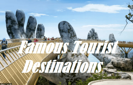
Famous Tourist Destinations
20 Top-Rated Tourist Attractions in the World
Travelers are always looking for inspiration to guide their adventures. Coming up with a list of places to visit can be challenging when you're staring at a globe. What are the top tourist attractions in the world? The most iconic sites that all travelers have on their bucket-list of things to see around the globe?
Some destinations just stand out above the rest. Many are the type of places where you can take a photo, and it requires no explanation to identify the location: the Eiffel Tower or the Colosseum. But some places are less well known to new travelers or those who have not yet ventured out to the more exotic destinations. These can often be the most rewarding to visit.
For many of these attractions, it's what they symbolize and the destinations they represent that make them so significant. In other cases, it is the site itself that makes it worth visiting the country. Some of these are the more popular UNESCO World Heritage sites.
If you're looking to start your own checklist of places to visit during your life, begin with our list of the top tourist attractions in the world.
Note: Some businesses may be temporarily closed due to recent global health and safety issues.
1. Eiffel Tower, Paris
Famous Tourist Destinations ,20 Top-Rated Tourist Attractions in the World
Eiffel Tower at night | Photo Copyright: Lana Law
The symbol of Paris and one of the most photographed structures in the world, a visit to the Eiffel Tower is a must for all travelers. Few landmarks inspire such a passion for travel as this single iron structure.
Young travelers heading out on the road for the first time, couples looking for a special getaway, artists looking to spur their creativity, and romantics of all types are all drawn to Paris. This is a city where history and culture collide and where travelers of all kinds can find the experience they're after.
2. The Colosseum, Rome
Famous Tourist Destinations ,20 Top-Rated Tourist Attractions in the World
The Colosseum
The most famous and largest structure still standing from the Roman Empire, the Colosseum is also the biggest attraction of modern-day Rome. It's been a bucket-list destination of travelers for generations. And it does not disappoint.
Set in the heart of the city, the Colosseum is an easy place to visit. Direct flights from around the world land in Rome daily, making it a destination you can visit in a weekend if you choose. Wander through Rome's ancient streets, tour the colosseum, and if time allows, plan a trip to other areas of Italy.
3. Statue of Liberty, New York City
Famous Tourist Destinations ,20 Top-Rated Tourist Attractions in the World
Statue of Liberty
America is full of great sights and places to visit, but it's the Statue of Liberty that represents the United States like no other place. This symbol of freedom in New York City was gifted by the French to the American people in 1896.
Of all the attractions in New York City, this is one every tourist must see. The best thing to do at the Statue of Liberty is to take a ride up to her crown and soak up the view over the city. Access to the statue is via ferry, also a highlight of a visit.
4. Machu Picchu, Peru
Famous Tourist Destinations ,20 Top-Rated Tourist Attractions in the World
Machu Picchu | Photo Copyright: Lana Law
If you are planning to see only one attraction in South America, this is the place to come. The ancient Inca city of Machu Picchu is arguably the most impressive ruined city in the world.
Much of the attraction comes from its location, high in the jungle-clad mountains of Peru. Set on a high plateau with soaring green mountains, the setting is surreal. The sheer tenacity of the original builders to create this amazing place in what would have been impenetrable jungle, is, in itself, impressive.
Visitor numbers are now limited to a maximum per day, so the experience has been greatly enhanced.
- Read More:
- Top-Rated Tourist Attractions in Peru
5. The Acropolis, Athens
Famous Tourist Destinations ,20 Top-Rated Tourist Attractions in the World
The Acropolis in Athens | Photo Copyright: Lana Law
Perched above present day Athens, the Acropolis draws you up and in. Follow in the footsteps of ancients as you walk up the same steps that have been walked on since 438 BC - 2,500 years.
Views out over the city are incredible as you walk between the meticulously restored ancient buildings. Near the end of the day, you'll want to linger and watch the sunset from the stairs near the entrance. This is a nightly ritual in Athens.
The site is also impressive looking up at it from the city below. Spend an evening dining on a rooftop patio to soak in the view of the hilltop ruins lit up at night.
6. The Taj Mahal, India
Famous Tourist Destinations ,20 Top-Rated Tourist Attractions in the World
Taj Mahal | Photo Copyright: Lana Law
The Taj Mahal is the one sight in India that all travelers need to see. The country is filled with incredible cities and fabulous places to visit, but the 17th-century Taj Mahal is the one place that says you've been to India.
This mausoleum, commissioned by the Shah Jahan for his wife, Mumtaz Mahal, is known internationally as a symbol of love. This fantastic structure, made with inlaid precious and semi-precious stones, has to be visited to be fully appreciated.
Its riverfront setting, surrounding gardens, and reflecting pools are also what make the Taj Mahal so special.
- Read More:
- Top-Rated Tourist Attractions in India
7. Pyramids of Giza, Egypt
Famous Tourist Destinations ,20 Top-Rated Tourist Attractions in the World
Pyramids of Giza | Photo Copyright: Lana Law
If you've visited places like the Colosseum in Rome or the Acropolis in Athens, built over 2,000 years ago, you may think you have a good handle on ancient sites. But the Pyramids of Giza take ancient to a whole other level. These were built over 4,500 years ago. Tourists were coming to see these magnificent structures literally thousands of years ago.
Located just outside Cairo, the pyramids, which is also where you'll find the Sphinx, are easy to get to, and tours are easy to arrange. A sunset camel ride around the structures is a wonderful experience.
8. Great Wall of China
Famous Tourist Destinations ,20 Top-Rated Tourist Attractions in the World
Great Wall of China
In a land of modern cities and towering skyscrapers, the Great Wall of China, built between the 14th and 17th centuries, is a stark contrast but a striking image that all visitors to China should see.
A stroll along the top of the wall provides an incredible view of the structure snaking off into the distance. The wall stretches an astounding 21,196 kilometers, through some remote areas.
Many travelers seeing the sights of China choose to visit the wall on easily organized tours from Beijing, a relatively short motorcoach ride away.
9. Angkor Wat, Cambodia
Stone faces at Angkor Wat | Photo Copyright: Lana Law
Surrounded by jungle and, in some cases, overgrown with huge trees and roots, the ancient structures of the Angkor complex may look like a movie set to some visitors.
Wandering through Angkor Wat, the main centerpiece of the complex, it's easy to feel like you've entered another era. This is without a doubt, one of the most impressive sites in Southeast Asia and the main reason many people visit Cambodia.
The stone faces peering out over the buildings and gates are images that you won't soon forget.
10. Petra, Jordan
Petra
You may have an Indiana Jones feeling as you walk through a 1.2-kilometer-long narrow crack in the sandstone hills and emerge into a hidden city. First built over 2,000 years ago and lost to the outside world for 600 years, the city was only discovered in 1812.
Stunning buildings are carved directly into the red rock walls and are wonderfully preserved, just begging to be explored and photographed.
If you arrive early, an eerie silence, coupled with long shadows, give this abandoned city a special feel.
- Read More:
- Top-Rated Tourist Attractions in Jordan
11. Grand Canyon, USA
Grand Canyon | Photo Copyright: Lana Law
The greatest natural attraction in the United States, the Grand Canyon is a key sight for all travelers planning their lifetime of adventures. Standing on the rim of the Grand Canyon, looking out over the carved landscape, will awaken your senses.
Several hikes in the canyon and along the rim offer unique perspectives. Walk even a short distance down the Bright Angel trail to gain additional views and to experience what the canyon is like below the rim.
For even more adventure plan a rafting trip down the Colorado River through the canyon.
The Grand Canyon looks different throughout the day and at different times of the year. One trip is never enough. If you are going to add this place to your to-see list, consider what you want to do here to determine the best time to visit.
12. Stonehenge, England
Stonehenge
Stonehenge is one of those places that makes you ponder what went on here over 4,500 years ago. It's long been a mystery to historians, and has captured the imagination of countless visitors. Despite the large number of tourists that descend on Stonehenge, the place still has a mystical feel.
At the site, giant stones, some standing, some fallen, are set in two roughly circular patterns that are oriented to highlight the summer and winter solstices. For a truly memorable experience, plan your visit during one of these times.
An easy day trip from London, Stonehenge can easily be worked into your UK itinerary.
13. Borobudur, Indonesia
Sunrise at Borobudur
Set in a steamy jungle with three volcanoes providing the backdrop, Borobudur is Indonesia's top tourist attraction.
Borobudur dates from the 9th century and is one of the largest Buddhist temples in the world. It's a fascinating place to wander about. Over 500 Buddhas are spread around the site, some of which sit under ornate stupas.
Try to visit early in the morning when you'll have the best chance of experiencing a bit of early mist, and the view to the volcanoes will be the clearest.
14. Niagara Falls, Canada & USA
Famous Tourist Destinations ,20 Top-Rated Tourist Attractions in the World
Niagara Falls in winter | Photo Copyright: Lana Law
On the border between the United States and Canada, these great falls have been drawing explorers and travelers for centuries. Just over an hour from the city of Toronto, Niagara Falls is easy to get to, and the town is a fun place to spend a night or two.
Walk up to the edge of the falls, stroll along the paved walk lining the gorge for different views, or take a boat tour for a close-up look at the water pouring over the lip of the gorge above you. For a bird's-eye view, head up the Skylon Tower to look out over the falls.
At night, see the falls lit in different colors. If you're visiting in winter, watch the huge plume of mist rising into the sky above the falls.
15. Bagan, Myanmar
Famous Tourist Destinations ,20 Top-Rated Tourist Attractions in the World
Bagan, Mayanmar | Photo Copyright: Lana Law
While this ancient site may not be on the average traveler's radar, it's another of Southeast Asia's bucket-list attractions.
Spread out over a lush plain are more than 10,000 sacred structures dating from 1044 through to 1287. Hire a bicycle and pedal your way from one amazing structure to the next, or take a tour. Some of the structures can be entered, but the real beauty is the sheer number that dot the landscape.
For an aerial view, consider taking a hot air balloon tour at dawn.
16. Sydney Opera House
Famous Tourist Destinations ,20 Top-Rated Tourist Attractions in the World
Sydney Harbour
Like many other attractions around the world, the Sydney Opera House is one of those places that is easy to identify and obviously associated with Australia. A photo of yourself in front of the white sails screams Australia.
The Sydney Opera House was built in several stages and officially opened in late 1973. To fully experience the building, take a tour inside to see the unique shape and hear the exceptional acoustics.
Soak up the view from the Opera House area back towards the world-famous Sydney Harbour Bridge.
17. Mount Kilimanjaro
Famous Tourist Destinations ,20 Top-Rated Tourist Attractions in the World
Mount Kilimanjaro
The highest peak in all of Africa, this majestic mountain - a dormant volcano - is one of the most recognizable symbols of the continent. The snowcapped peak is often the backdrop to photographs of the wild animals that roam Amboseli National Park and other areas.
You can see this beautiful sight from afar or tackle the multi-day hike to the top of Mount Kilimanjaro for the fantastic views over the land and to watch the sunrise.
- Read More
- Top-Rated Tourist Attractions in Tanzania
18. The Louvre, Paris
Famous Tourist Destinations ,20 Top-Rated Tourist Attractions in the World
The Louvre, Paris | Photo Copyright: Lana Law
If there is one museum in the whole world that you absolutely must see in your life, it's the Louvre. Even if you are not a fan of museums, this one is worth the trip to Paris to see.
Although most people know it as the home to the most famous painting in the world, the Mona Lisa, this is just one of the reasons to visit the Louvre.
The museum holds countless masterpieces by the greatest artists that have ever lived. But even the building itself is an icon. The glass pyramids and the 18th-century building are recognizable to almost everyone, and have been shown in countless movies.
19. Forbidden City, China
Famous Tourist Destinations ,20 Top-Rated Tourist Attractions in the World
Forbidden City
Like the Great Wall, the Forbidden City in Beijing is one of the top places to visit in China. The sprawling complex dates from the 14th and 15th centuries and is a spectacular example of historical China.
Over the centuries, the palace has housed 24 Ming and Qing Emperors. Inside the city, the Palace Museum holds over 340,000 artifacts showcasing the treasures of China's dynasties. In front of the Forbidden City is Tiananmen square.
20. Prague Castle, Czech Republic
Famous Tourist Destinations - IDENTYBEAUTY
Prague Castle
Sitting atop a hill across the river from the center of the city, Prague Castle casts an imposing aura over its surroundings. The castle is an incredible collection of buildings constructed from the 9th to 14th century.
Stroll over the ornate 14th-century Charles Bridge spanning the Vltava River and head up the hill to wander the narrow, twisty streets in the castle complex. The castle is one of the largest in the world, and around almost every corner is a historical building, church, or open square.
Famous Tourist Destinations - IDENTYBEAUTY
Read the full article
0 notes
Photo
Celebrate Canyonlands National Park's Anniversary September 12th
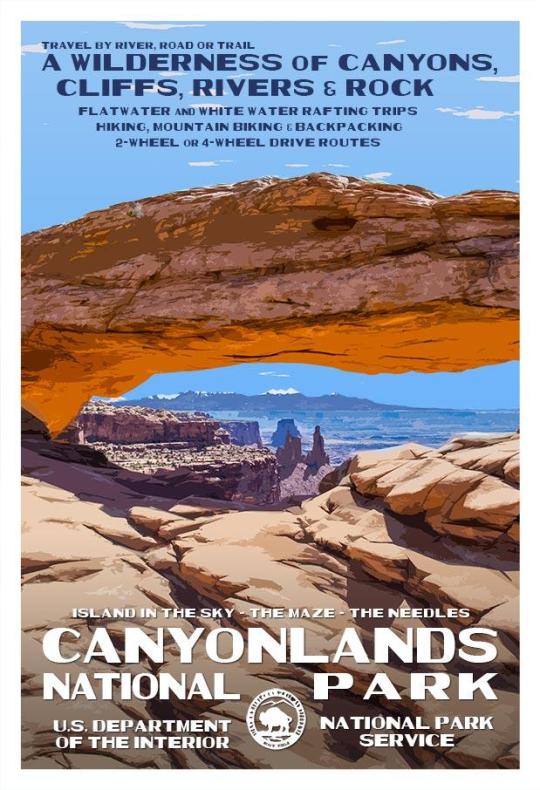
Celebrate Canyonlands National Park's Anniversary September 12th: Canyonlands National Park was established on September 12th, 1964, which preserves 337,598 acres of colorful canyons, mesas, buttes, fins, arches, and spires in the heart of southeast Utah's high desert. Water and gravity have been the prime architects of this land, sculpting layers of rock into this rugged landscape. In the early 1950s, Bates Wilson, then superintendent of Arches National Monument, began exploring the area to the south and west of Moab, Utah. After seeing what is now known as the Needles District of Canyonlands National Park, Wilson began advocating for the establishment of a new national park that would include the Needles. Additional explorations by Wilson and others expanded the areas proposed for inclusion into the new national park to include the confluence of Green and Colorado rivers, the Maze District, and Horseshoe Canyon. In 1961, Secretary of the Interior Stewart Udall was scheduled to address a conference at Grand Canyon National Park. On his flight to the conference, he flew over the Confluence (where the Colorado and Green rivers meet). The view apparently sparked Udall's interest in Wilson's proposal for a new national park in that area and Udall began promoting the establishment of Canyonlands National Park. In 1962, the Canyonlands park bill was introduced by Utah Democratic Senator Frank Moss. Also that year, the U.S. Department of the Interior published a paper entitled A Proposed Canyonlands National Park containing this evocative passage: "Rock -- carved, colored and clothed by weather -- controls the character of our land. Nowhere is the relationship between earth's framework and the forces that shape it more dramatic than in the plateau and canyon country of the American Southwest." On September 12, 1964, after several years of debate, President Lyndon B. Johnson established Canyonlands as a new national park. Bates Wilson became the first superintendent of the new park. He is often referred to as the "Father of Canyonlands." Canyonlands expanded to its current size of 337,598 acres on November 12, 1971 when the Maze, the Land of Standing Rocks, as well as Davis and Lavender canyons were added to the park. While each district shares a primitive desert atmosphere, each retains its own character and offers different opportunities for exploration and adventure. Though they appear close on a map, there are no roads that directly link the districts. Traveling between them requires two to six hours by car as there are few places to cross the rivers. Get directions. Most people find it impractical to visit more than one area in a single trip. Click Here to See the Canyonlands National Park Poster! If you're interested in other Canyonlands National Park gear, check out the men's and women's t-shirts, cell phone cases, neck gaiters and field journals. They're all perfect for showing off your Canyonlands National Park pride! Click here to see the Canyonlands National Park T-Shirt Click here to see the Canyonlands National Park iPhone cases. Click here to see the Canyonlands National Park Samsung cases. Click here to see the Canyonlands National Park field journal Rob Decker is a photographer and graphic artist who studied under Ansel Adams in Yosemite National Park when he was just 19 years old. Now, he's creating iconic WPA-style posters for each of our National Parks. Click Here to learn more about his story and The National Park Poster Project. https://national-park-posters.com/blogs/national-park-posters/celebrate-canyonlands-national-parks-anniversary-september-12th?utm_source=rss&utm_medium=Sendible&utm_campaign=RSS
0 notes
Video
flickr
Far Off Places Seen in Mesa Verde National Park by Mark Stevens
Via Flickr:
A setting looking to the southeast while taking in views from the Far View Terrace Café and then across this southeastern Colorado landscape. This is in Mesa Verde National Park.
#700 Years Tour#Ancestral Puebloan#Ancestral Puebloan Archaeological Sites#Archaeological Preserve#Archaeological Sites#Azimuth 140#Colorado Plateau#Day 6#DxO PhotoLab 7 Edited#Far View Terrace CafŽ#Intermountain West#Landscape#Landscape - Scenery#Looking SE#Mesa Verde National Park#Nature#New Mexico and Mesa Verde National Park#Nikon D850#No People#Outside#Partly Sunny#Project365#Rocky Mountains#Scenics - Nature#SnapBridge#Southeast Colorado Plateau#Sunny#Travel#Ute Mountain Area#World Heritage Site
0 notes
Photo

The Colorado Plateau
This satellite image (with state lines superimposed) shows one of the most impressive geologic provinces in the United States: the Colorado Plateau.
The Colorado Plateau is an area of high ground in New Mexico, Utah, Arizona, and Colorado. It is bounded by mountain ranges in the north and areas dropped down by normal faults in the southeast and southwest However, the plateauitself has behaved as a single block, moving nearly in tact despite mountains growing around it.
This block of stable, hard to deform continental crust has given the United States some of its most amazing natural features. Since this block of crust has remained undeformed for several hundred million years, sedimentary layers deposited on top every time it was submerged have had little deformation. The Plateau was elevated as a block during the building of the Rocky Mountains and has sat at high elevation for tens of millions of years. This has allowed erosion, including drainage by a major river, to sculpt the area. These processes, including erosion by the Colorado River, have sculpted the 10 national parks and 18 national monuments found in the area.
-JBB
Image credit: https://en.wikipedia.org/wiki/Colorado_Plateau…
References: https://geomaps.wr.usgs.gov/parks/province/coloplat.html http://bit.ly/2w6FOEH
#Colorado#Utah#Arizona#new mexico#Geology#crust#continent#colorado plateau#erosion#national park#earth from space#The earth story
100 notes
·
View notes
Photo


Colorado National Monument (No. 9)
Grand Valley begins where the Colorado River widens at the mouth of De Beque Canyon to the east of Palisade, then follows a wide arc bending to the west. The Colorado receives the Gunnison River, one of its major tributaries, just south of Grand Junction near the midpoint of the valley. The valley is surrounded by large plateau formations, including the Book Cliffs along the north side, the Grand Mesa along the southeast side, and the Uncompahgre Plateau to the southwest. Colorado National Monument sits on a ridge on the southwest side of the valley west of Grand Junction. Much of the surrounding table land areas rimming the valley are public lands controlled by the Bureau of Land Management.
The name "Grand Valley" has been associated with the area since the mid-nineteenth century. The present Colorado River above Grand Junction was known as the Grand River as early as 1842. The city of Grand Junction was so named because of its position at the junction of the Gunnison and Grand Rivers. The Green and Grand Rivers united in eastern Utah to become the Colorado River. The Grand River was renamed Colorado River by act of the Colorado State Legislature, approved March 24, 1921, and made official July 25, 1921 in House Joint Resolution 460 of the 66th Congress. In addition to Grand Junction, the name "Grand" still remains in the Grand Valley between Palisade and Mack; in Grand Mesa, which stands more than a mile above the Grand and Gunnison Valleys and in Grand County, Colorado.
Source: Wikipedia
#Independence Monument#Colorado National Monument#Colorado River#Colorado#fields#canyon#cliffs#original photography#Colorado Plateau#desert#flora#nature#rock formation#red rock#summer 2022#landscape#countryside#tourist attraction#landmark#Mesa County#Book Cliffs#Grand Valley#blue sky#clouds#bush
2 notes
·
View notes
Video
The Mojave Desert occupies more than 25,000 square miles (65,000 square km) and joins the Sonoran, Great Basin, and Chihuahuan deserts in forming the North American Desert. The Mojave extends from the Sierra Nevada range to the Colorado Plateau and merges with the Great Basin to the north and the Sonoran Desert to the south and southeast. It abuts the San Gabriel and San Bernardino mountains in the southwest.
Credit to @vacationee on Instagram
Location: California
.
.
.
#wanderlust #Instatravel #traveller #beautifuldestinations #traveldiaries #tlpicks #earthpix #travelgram #Travel #adventure #wanderlust #vacation #explore #explorers #holiday #Travels #Traveller #Traveling #Backpacking #Travelphoto #TravelPhotography #Travelinggram #travelblog #travelblogger #traveladdict #exploretocreate #youliketotravel #travelphotography
0 notes
Note
post your coolest lizard
Excellent ask. Thank you for indulging me and bringing up herps. Wish I had some better photos to share, but, honestly, I’m a bad source of lizard stuff because I spend a lot more time with amphibians rather than reptiles. Most of my work or adventuring happens on rainy nights, or in mountains and wet coniferous forest, in habitats and at times when amphibians are very active but reptiles are mostly sheltering underground or at lower elevations. In the region where I live, there are only three or four lizard species present. So, I’ve got no shortage of access to, like, toads or Extremely Cool salamander content, but most of my lizard encounters have happened while traveling.
This is Ignacio.

Ignacio was an ostensibly “wild” black spiny-tailed iguana (Ctenosaura similis) whomst I befriended. I spent a few weeks in the same tiny little one-room beachfront shack thing on the coast of Gulf of Honduras. The shack was maybe 15 meters from the sea itself and from a pier that lobster divers and fishermen used every day. And Ignacio (I chose the name) would chill right outside my door on these old abandoned wooden lobster traps, and he would casually walk through my perpetually-open door into my little shack and then steal fruit. (There was only like an end table and a single couch, nothing else. I pretty much only ate fruit and rice/beans at the time, so fruit was always stocked yet I had no refrigerator or enclosed pantry.) So eventually I would just “accidentally” leave out “extra” fruit and Ignacio would just hang out for hours and he gradually became more comfortable with me. I loved him.
—
So, I am also immediately reminded of what is probably my most memorable encounter with a lizard, which was very exciting and surprising to me at the time. I almost literally stepped on a big (35-centimer-long) blue-tongued skink (Tiliqua scincoides) which was sitting completely exposed on the steps of the National Archives of Australia, in the heart of Canberra within a few paces of parliament and the prime minister’s office. The reason this is so memorable to me is that I’m still amused by the juxtaposition of a big, angry, wild reptile just sauntering around the formal, colorless, dire European architecture and imposing symbols of state power; as if, despite settler attempts to introduce European vegetation and infrastructure and control, native Australian species are still like “manicured rose gardens? lmao, nah, I think I’m just gonna stroll over here anyway bro.” Love the poetry of it.
What added to the surprise was that this happened on a rainy night, an hour or two after sunset, in the middle of winter (July 2006), none of these conditions very appealing for a reptile. She delivered the classic skink performance; she hissed and stuck her tongue out and everything. The only “habitat” in the area were the lawns of monotonous European grass, inundated with fertilizers, though the National Rose Garden is immediately adjacent to the steps. I was surprised that the lizard was not only active during a cold drizzle of rain during winter, but that an animal that big was just … hanging out in the ecologically-sanitized heart of a “major” city. That said, I’ve since learned that blue-tongued skinks are regularly encountered in gardens and residential yards in Sydney, Melbourne, and other major population centers of the temperate southeast of Australia, so maybe my encounter wasn’t entirely unusual. (I was just visiting; I’m not from Australia.) I took one really grainy photo of the skink, but the hard drive has since been lost.
—
The most recent lizard that I found somewhat “close to home” was this one:

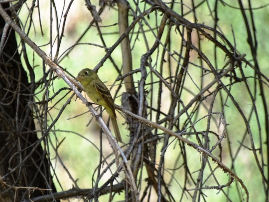
Nothing too out of the ordinary, especially if you’ve lived in or visited western North America. This is Phrynosoma brevirostris, a species of “short-horned lizard” from shortgrass prairies, badlands, and mountain foothills in the Wyoming Basin, northern Colorado Plateau, and northern Great Plains. A relatively common sight in the region. They turn up in some cool places; I’ve seen them in pinyon-juniper or ponderosa woodlands at elevations of 2100 meters/7,000 feet in Rockies of Colorado and Montana, but then they also love the exposed rock of buttes and sandstone formations in badlands of, like, the Yellowstone River watershed.
Anyway. Thank you, honestly, for the ask. Still wish I had more lizards to share.
8 notes
·
View notes
Photo
Prickly pear and claret-cup cactus (these will soon be showing off their bright spring blooms), and the view from the Toroweap desert water tanks. Here is a photograph of one of the many Fairy Shrimp residing briefly in these ran filled desert water pools at Toroweap: www.flickr.com/photos/12150532@N04/32824618843/in/photost... I stopped on my loop hike and later Fred and I returned to these artistic desert water tanks, some brimming with Fairy Shrimp - - to photograph them and enjoy the sight of the short lives of the desert Fairy Shrimp. ~~~~~~~~~~~~~~~~~~~~~ Not one to sit still for long, I took photos at the overlook and then walked south to photograph Vulcan's Throne and Lava Falls. Then returned to hike the rim of the canyon along a circular route, cutting through the empty of campers, campground, and spending time enjoying the fairy shrimp show, in many of the recently filled desert water tanks. Part of the appeal of Toroweap is there are no signs saying "if you fall over the edge it is a long way down" or five foot high cyclone fences keeping you away from the canyon rim edge. In short you have to use good judgment and the park service doesn't try to warn and protect the lives of everyone. who can't use common sense, good judgment and care. In other words: Let Natural Selection .... work. ~~~~~~~~~~~~~~~~~~~~ Fred and I did our best to contact "somebody" with the park service, BLM, or any ranger station to find out the conditions of the roads leading to Toroweap (Tuweep) and to see if we could get a permit to camp there for one night (Friday March 3rd, 2017). We couldn't reach anyone and when we were given the opportunity to leave a call back number, nobody did. We decided to head for Kanab, Utah and spend Friday night there and head out to Toroweap early the Saturday morning and make a day trip out of it. There are three roads into Toroweap: 1. From St. George, called the Main Street Route. It is 90 miles long and climbs up over the south shoulder of Mt. Trumbull (good petroglyph panel). It is impassable in winter due to snow and mud. It is the route I took on my first visit to Toroweap in April of 2008. 2. From Colorado City, called the Clayhole Route. This is the shortest way in, just 56 miles but it is impassable when wet (and it had been wet before this March 2017 trip). 3. West of Fredonia, is the so called Sunshine Route. It is 61 miles and is the most dependable way in to Toroweap. That is the road I came out of in 2008 after camping at Toroweap (first come first serve camping back then). And this is the road Fred and I took to and from Toroweap from Kanab. No matter which of the three routes you take in, there is now a gate past the rangers' station, which doesn't allow vehicles to get in and out during "off hours", so no stealth camping. And the road between the rangers' station and the viewpoint and campground at Toroweap, takes care, caution, and high clearance for the last mile or two. Big towing bill if you do a transmission on this stretch. We had a long talk with volunteer ranger Bob on the way in (and later on the way out). The campground was empty he told us and if we could have camped had we known, who to contact (we do now). Oh well. Next time. We saw only a handful of people at Toroweap. Most seemed intent on doing a Chevy Chase "vacation" visit to this beautiful sight. They drove up took a few photos, and left. Fred and I wandered the canyon rim and spent considerable time enjoying the desert water tanks, full from recent rains, and some alive with fairy shrimp. Fairy Shrimp [Branchinecta lynchi] and Tadpole shrimp have incredible "survival and reproduction" strategies as many plants and animals of harsh desert environments do. Freshwater shrimp can complete an entire life cycle in two weeks if needed: egg to egg laying adult. Freshwater shrimp produce two types of eggs. 1. non-fertilized eggs and thick walled "resting eggs". The first kind are produced when water and food are both abundant and hatch only females. When the pools start drying up, food is scarce, and the chemistry of the stagnant water changes - the shrimp produce eggs of both sexes. This generation of mating shrimp produce the "resting eggs". These can withstand freezing, boiling heat, and complete drying out of the eggs (for decades, even for 100 years) UNTIL the next fresh water in the right amounts, falls again. The "resting eggs" can only hatch if the pool dries out completely. Fairy Shrimp, have two pairs of 11 legs, which they use to row their way around in life, swimming upside down. Their color tends to reflect what they eat, so the fairy shrimp at Tuweep were "green" looking. Algae eaters no doubt. They usually hatch in January and die in early March. I will post a few photos I took of the fairy shrimp in the pools at Toroweap. Here is the link to photographs taken, when I camped at Toroweap in April of 2008. A campground owl kept up his call, all night long and a beautiful moon crossed the night sky. A wonderful experience: www.flickr.com/photos/12150532@N04/albums/72157604781519716 ~~~~~~~~~~~~~~~~~~~~~~~ Friday the 3rd of March, 2017: The weather was great. Warm and sunny. Fred and I spent hours hiking the plateau containing innumerable, unique, and artful sandstone rock forms. Little Finland, now located in the Gold Butte National Monument. ~~~~~~~~~~~~~~~~~~~~~~~~ The Story: There is beauty in winter I do like living in a place where there are four seasons to look forward to. Winter, however, is not my favorite (that would be Autumn). What I have against winter is: 1. adverse road conditions where "getting out" on the road is dangerous, stressful, or impossible. 2. long nights and short days. 3. too much snow, clouds and high winds. 4. cold. I list cold last for good reason. You can dress for cold weather and if the roads are OK, and the weather good there are a lot of things I enjoy doing during the short days of winter. The winter of 2017-2017 has been the absolute worst year in a decade, for poor road and driving conditions (ice, snow, visibility, slush, wind, etc.) The result: cabin fever and too many jigsaw puzzles. So after the last football game on TV I started looking forward to heading to the Southwest as a way to "get outside" and hike and drive back roads as soon as possible. I watched the 15 day weather forecast like a hawk for all the towns closest to my favorite places in Utah, Arizona, and Nevada. Turns out there were some really nice windows of great weather in Southern Utah, Arizona, and Northeastern Nevada in January and February. I was primed to go. I even stirred up some interest among a few of my like minded friends. The problem: When roads were good to drive in Eastern Washington (where I live) and wonderful in the Southwest (where I wanted to go), the roads in between were terrible (covered and iced, traffic accidents, and road closure signs). Around the first part of February there appeared to be a brief opening for road conditions from here to there, with great weather: there (The Southwest). I had two of my road trip friends convinced to go for it, but then yet another succession of winter storms moved across the Western states and I was forced to admit - - road trip #1 for 2017 was not a go. My friends agreed. Trip cancelled. Cabin Fever continued. Another SW road trip weather and road conditions window happened around the 22nd of February. Ed, a good friend and an excellent photographer, whom I have traveled with many times on road trips, had an opportunity to join me. His wife was back in the Southeast helping out their daughter, who was having major foot surgery, and my wife was in Colorado with her two little granddaughters day care duties. So Ed and I set the 22nd of February as our departure date. We had motel reservations set in Boise for the way down and back and then several days at St. George, Utah, where we intended to use as our "base camp" for drives, hikes, and photo ops in the Arizona, Utah, Nevada corner of the Southwest. Ed picked me up in his nice Jeep Wrangler on the 22nd and we were on our way. What a great feeling it was to be "on the road again" and out of the house! We headed for Boise, where we had rooms reserved for Wednesday night the 22nd. Between my house and Boise the roads had been ice and snow clear. No problems driving at all. We headed out of Boise for St. George, at dawn on the morning of the 23rd of February. The farther east we traveled on the interstate, the higher the winds became, snow started falling and worst of all, ice patches started showing up on the interstate. I-84 east of Boise, is an 80 mph highway that some folks will drive at 80 mph, even when ice and snow on the road, coupled with poor visibility tell most reasonable people, that isn't a great idea. About 100 miles from Boise near an exit off I-84 (near Bliss, Idaho), traffic came to a stop. State police were directing everybody off the interstate eastbound, who had not yet passed that exit. The interstate was closed down due to a wreck involving to semi rigs, on the ice covered freeway. We were lucky. Had we arrived ten minutes earlier we would have been past the exit and stuck in the long parking lot of cars, having to wait for hours for the wreck to be cleared and the eastbound lanes re-opened. Ed and I checked the maps and he used a smart phone ap to see that roads all over the area were showing no movement of traffic. It appeared we could get around the wreck by taking highway 26 as others were doing, but I wanted to be certain and ask about the interstate road conditions beyond the wreck between Bliss and Salt Lake City. I jumped out of Ed's Jeep and in blizzard conditions, went over to a police vehicle blocking access to the interstate. He rolled down his window and confirmed that yes, you could get around the wreck by taking a loop on highway 26 but it was slow going with all the interstate traffic, attempting to do so. When I asked about the highway and weather conditions beyond the wreck to Ogden and Salt Lake City, he just shook his head and said "terrible". I returned to the Ed and his Jeep with the bad news, and though both of us hated the decision, we decided to abandon our trip to the Southwest. We called and cancelled our room reservations and started back to Boise, Baker City, La Grande, and Pendleton. Ironically the farther we drove towards Eastern Washington, the better the weather and roads became. At Pendleton, the sun was shining, so we decided to salvage the day and took off for Walla Walla, Dayton, and Starbuck, Washington to visit and photograph Palouse Falls. Ed spent Thursday and Friday nights at my house, so Friday, we took a good weather consolation drive along back roads in the Ellensburg, Washington area to photograph some wildlife and winter snow scenes. Saturday morning Ed headed back over Snoqualmie Pass to his home. Exactly one week after Ed and I had given our Southwest trip a try, I decided that the roads and weather forecast again "looked right" for a the trip that had now twice been abandoned. I didn't feel right asking Ed to commit to another attempt, especially since his wife would be returning home from their daughter's place, so I decided to make Mesquite, Nevada, instead of St. George, Utah, my destination and go solo. I called up another "like minded" road trip, backpacking, hiking friend in Boise (Fred), to let him know I was going to give "strike three" a chance, and head out on in my pickup truck on Wednesday the first of March 1st, 2017, as early as possible. Fred (suffering from major cabin fever, like me), said he would love to meet up with me in Nevada, though he only had a narrow window of two days to spend in the area, due to his work responsibilities. So, I sheepishly called my wife and told her "You won't believe this (but after being married 46 years, of course it didn't surprise her), but I am going to give the trip another - go". Wednesday 3.1.17 I drove to Ely, Nevada.There was only ONE icy interstate section about ten miles long east of Baker City, Oregon, where they reduced the speed limit temporarily to 30 mph, but once past that - - dry road only. When I got to Ely, I got a room for the night. The next morning it was 9 degrees, but no wind, no snow, clear dry highway and THE SUN WAS SHINING. Just before the intersection of Nevada's highways 93 and 168, where I would cut over towards Mesquite, Nevada. My pickup truck shook, then a loud noise boomed. A few seconds later it happened again. I knew immediately what it was, given where I was. Fighter jets (twin tail dual exhaust), were heading single file for some above the desert flight training. They were flying on the deck (a few hundred feet above the ground and at high speed). I pulled over and stopped to watch the last jet cross the road above me and then pull into a vertical climb to join the flight formation gathering. It was a wonderful experience. I got to Mesquite, Nevada and got a room and got my hiking gear ready to go for a trip out to the very recently designated Gold Butte National Monument, a short distance southwest of Mesquite. A cell phone from Fred said he would meet up with me early Friday morning for the back road driving, hiking, and photo ops at: Whitney Pocket; Devil's Throat; and the fascinating rock formations of Little Finland by Mud Wash. We piled into Fred's vehicle Friday morning (a nice roomy Ford Explorer rental unit), and were on our way. The weather was perfect. Few other people out in the area that day. We spent the day hiking and photographing, and bumping along the designated back road routes in the area. To add a little excitement to the day, the left front time of Fred's vehicle blew a hole through the sidewall, while traveling Mud Wash. A Laurel and Hardy scene ensued, as we read the owner's manual, unloaded the back of the Ford Explorer, and got the doughnut spare put on. (Fred doing all the heavy work. Me claiming old age as an excuse for doing the light work associated with the tire change). We got back to Mesquite in time for Fred to get the blown tire replaced and for the two of us to have a nice Mexican dinner at Mesquite. They even had horchata, my favorite drink, when I used to work in Mexico from time to time. Before dawn the next day (Saturday March 4th) we were on our way to Toroweap on the North Rim of the Grand Canyon. It was a 56 mile drive, (by the best route) on dirt roads, with a four wheel drive only section near the end. The road started just west of Fredonia, Arizona. There was some conflicting information on whether or not any of the road would be open to Toroweap and we tried in vain, to see if we could obtain a permit to camp the night there. All worked out well though. We decided to spend the night in Kanab, Utah, and make the Toroweap a "day trip", which we did. NOTE: My first and only other trip to Toroweap was in April of 2008. Friend Ed (who had attempted this trip with me a week earlier), friend and photographer John, my son Derek, and I had all four camped at Toroweap on that occasion. We took the long route in from St. George on that trip. With John's guidance, I had just purchased my first digital camera: a Canon Powershot G9, and was trying to learn how to use on the spot. Here are my Flickr photos of that Toroweap trip and camp out: www.flickr.com/photos/12150532@N04/albums/72157604781519716 Fred and I spent the entire day at Toroweap and were surprised to learn that the campground was open but not one person was camping there. I hiked through the campground later in the day and visited site number one, where Ed, John, Derek and I had camped 9 years ago (no permit required then, just first come first serve). I was delighted to find fairy shrimp in some of the sandstone water tanks at Toroweap. Along with tadpole shrimp, I find their life strategy (with eggs viable for up to a century), fascinating. We celebrated our Little Finland on Friday and Toroweap on Saturday good weather and good fortune, with a wonderful, end of the trip dinner at the "Rocking V" in Kanab. I did justice to a one pound rib eye steak and Fred went local with some bison steak washing the meal down with his beverage of choice: a Spiral Jetty. Thanks Fred. Sunday morning Fred headed back to Boise and I dithered. I thought about extending my stay with some hikes in the area but winds in excess of 20 mph and cold weather was going to move into Southern Utah. My wife would be flying home on the 10th, so I decided to start on home myself. I got a surprise on the drive home. North of Ogden, it started blowing and snowing. It got worse and worse until visibility was really a problem, with snow on the road but fortunately no ice. All the way to Twin Falls, it was near blizzard conditions. Then the snow stopped for most of the way to Ontario, Oregon, where I got a room for the night after seeing the huge "Winter Driving Conditions Ahead" warning sign, across the freeway. Monday morning the 6th of March: no wind, no snow, dry road, sunshine. I drove from Ontario to La Grande, Oregon. No problem. Then across the Blue Mountains between La Grande and Pendleton, I was reminded that winter is not yet over in the Pacific Northwest. Solid ice on the road and 40 mph across the Blue Mountains. I kept my pickup truck in 4WD, Everyone, mostly truckers, were driving sensibly in the conditions, so I didn't see any accidents or vehicles in the ditch. I was sure glad I hadn't tried driving the road the night before. At a lunch stop at Meacham (yes of course: biscuits and gravy, side of bacon, and big glass of milk at the Oregon Trail Cafe), locals talked of the snow that was due in the mountains that night. I was pleased to arrive home by noon on Monday the 6th of March, 2017. A good road trip, excellent hiking, good company, and I managed to gain weight on the trip (might have had something to do with Mexican dinner, in Mesquite; Steak dinner in Kanab; and more biscuits and gravy at Meacham). Enjoy some of the photographs. Oldmantravels 7 March 2017 https://flic.kr/p/SHruN5
2 notes
·
View notes
Text
Fwd: Job: SaltLakeCity.VertebrateCollectionsManager
Begin forwarded message: > From: [email protected] > Subject: Job: SaltLakeCity.VertebrateCollectionsManager > Date: 14 February 2020 at 08:26:32 GMT > To: [email protected] > > > *Collections Manager, Vertebrate Zoology* > Regular Full-Time > Salt Lake City, UT, US > > The Natural History Museum of Utah(UMNH)seeks a Collection Manager for its > Vertebrate Zoology collections of approximately 90,000 specimens(44,000 > mammals, 23,000 birds, and 23,000 reptiles and amphibians), including dry > specimens (study skins & skeletal elements), fluid-preserved specimens > (in ethanol), and tissues (in 95% ethanol). The collections are among the > largest from the Great Basin and Colorado Plateau regions, and include > important material from Mexico, Central America, Australia, southeast > Asia, and Pacific Islands. This position is directly supervised by the > Curator of Vertebrate Zoology. > > The Collection Manager will oversee all aspects of the management > and utilization of the Museumขs vertebrate zoology collection > including processing incoming and outgoing loans, collaborating with > NHMU Collections and Research colleagues, facilitating the use of > the collection by researchers, and supporting the needs of other NHMU > departments including Exhibitions, School Programs, Public Programs, > Outreach, Development, Marketing, and Public Relations. The Collection > Manager will have primary responsibility for collection maintenance, > preparation and integration of new specimens, specimen cataloging, > database management, digitization projects, physical improvements, > and coordinating the activities of student assistants and volunteers. > > Other duties include participation in institutional planning, preparation > of grant proposals for collection support. The successful applicant > may also lead or participate in field and collections-based research, > and engage in other areas of professional development. > > At the Natural History Museum of Utah, we recognize that our strength and > sustainability as an organization stem from diversity and inclusion. For > this reason, we are committed to fostering equity, recruiting and > retaining a diverse workforce that reflects the communities we serve, > and empowering staff members in developing an accessible and inclusive > work environment. > > We also place a strong emphasis on providing an exceptional experience > to every guest who visits the museum or participates in any of our > programs. We believe that everyone, at every level and in all departments, > are a critical part of providing this level of experience. Therefore, all > staff members receive ongoing training and are expected to consistently > contribute to creating exceptional, memorable, and inclusive experiences > for our guests, partners, and the community. > > RESPONSIBILITIES > > - Cares for the vertebrate collection on a day-to-day basis, including > organizing and conserving specimens. Plans and oversees the > digitization, rehousing, and movement of the collection as necessary > and/or directed by the Curator(s). Assists with the development and > implementation of plans and goals for the collection. Facilitates > visits by outside researchers using the collection. > - Responsible for collection maintenance and documentation including > database management, loan processing, and collection digitization. > - Plans for collection growth and improvement. Works cooperatively with > other collection management staff to achieve the highest level of > collection care and productivity across the Museum. > - Processes incoming and outgoing specimens and/or materials including > new field specimens, donations, exchanges and loans in collaboration > with the Registrar. Maintains extensive knowledge concerning specimens > in the collections and the organisms they represent. > - Supports the planning, installation, and maintenance of temporary > and permanent exhibits. Expedites the use of collection of materials > for display. > - Participates in public and school educational program activities of > the Museum including, but not limited to, tours for the public and > Museum members, training of Museum volunteers and Gallery > Interpreters, engagement with Youth Development Program participants, > and participation in public Museum events. > - Facilitates outside research visits of scientists using the > collection. > - Prepares or assists in preparing permits, grant proposals, audit > reports, protocols, publications and articles. > - Assesses related training needs and coordinates training programs to > meet those needs for collections staff, students, and volunteers. > Supervises work of part-time staff, students, and volunteers. > - Stays abreast of current professional standards and legal or other > related changes impacting the collection and makes recommendations for > improvement and compliance. > - Advocates for natural history collections and effectively communicates > their importance to members of the public and the scientific > community. > - May lead or participate in ongoing or original research related to the > collection. > > MINIMUM QUALIFICATIONS > > - Bachelorขs degree in a related field plus two years of related > experience or equivalency. Demonstrated human relations and effective > communication skills also required. > - Applicants must demonstrate the potential ability to perform the > essential functions of the job as outlined in the position > description. > > PREFERRED QUALIFICATIONS > > M.S. degree in biological sciences with an emphasis in vertebrate zoology > (herpetology, ornithology, or mammalogy) or equivalent experience, > familiarity and experience with vertebrate zoology collections and their > use in research is essential. > > OTHER INFORMATION > > Position pen until filled. Submit a current resume and a cover letter > describing how your experience, knowledge, and interests qualify you > for this position through the University of Utah employment website: > https://ift.tt/2SqlEjv > > > Eric Rickart, PhD > Curator of Vertebrate Zoology > Natural History Museum of Utah > 301 Wakara Way > Salt Lake City, UT 84108 > (801) 585-7759 > > "Shannen L. Robson" >
via IFTTT
0 notes
Video
🌟🌟Featured Video🌟🌟 from @rjp5150 - Drone footage from Rio Grande Gorge Bridge in Taos. The approximately 50-mile gorge runs from northwest to southeast of Taos, starting near the Colorado border. The river has cut through the basalt flows of the Taos Plateau volcanic field. The gorge depth is 800 feet just south of the Rio Grande Gorge Bridge, which spans the gorge 10 miles northwest of Taos. (at Rio Grande Gorge Bridge)
19 notes
·
View notes
Last Seen Blogs

vk-ento
えんとう®神戸風

afewmarvelousthoughts
A Few Marvelous Thoughts

savage-flirtation
Savage Flirtation

stuffiluv
Stuff I Luv

ashysmultifandomcatdump
Ashy’s Multifandom Trash Dump