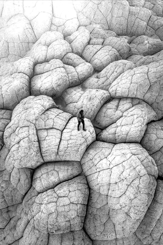
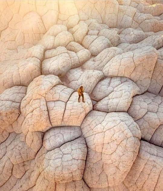
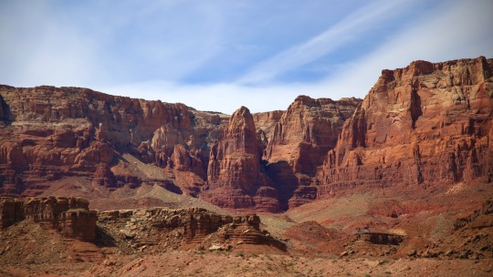
#Vermillion Cliffs National Monument
Text
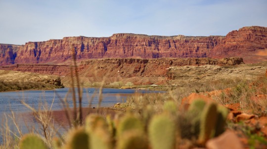
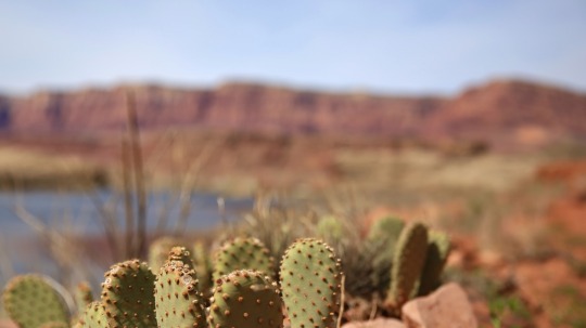
#lees ferry#vermillion cliffs national monument#adventure#travel#my photo#southwest#desert#arizona#the colorado river#the paria river#colorado river#nature#photography#aesthetic#colorado plateau#prickly pear#cactus
316 notes
·
View notes
Text
The federal Animal and Plant Health Inspection Service is proposing to spray toxic insecticides within treasured and significant landscapes of the Colorado Plateau in northern Arizona to kill native grasshoppers.
The areas being considered include portions of the Vermilion Cliffs National Monument, Grand Canyon-Parashant National Monument, and the newly designated Baaj Nwaavjo I’tah Kukveni – Ancestral Footprints of the Grand Canyon National Monument.
“This is a dangerous plan that could kill creatures that are key to northern Arizona’s unique biodiversity, which these national monuments were designated to protect,” said Taylor McKinnon, Southwest director at the Center for Biological Diversity. “The federal government needs to stop downplaying the extinction crisis and back off its reckless plan to smother biodiversity hotspots with toxic pesticides.”
One out of every 10 plant species in the Colorado Plateau region is found nowhere else on Earth.
The agency's draft environmental assessment omits mention of the national monuments and unique species and habitats they were designated to protect. These species include rare bees, butterflies and other creatures found nowhere else, like the Kaibab monkey grasshopper and House Rock Valley chisel-toothed kangaroo rat, specifically named in the August proclamation establishing the Baaj Nwaavjo I’tah Kukveni National Monument.
APHIS oversees and funds the application of multiple pesticides on rangelands to prevent native grasshoppers and Mormon crickets from competing with livestock for forage.
The proposed insecticides — carbaryl, diflubenzuron and chlorantraniliprole — are indiscriminate. In addition to the grasshoppers the agency is targeting, the insecticides can also kill bees, moths and other insects. Spraying can harm entire ecosystems by disrupting pollination and can harm populations of birds, reptiles and mammals who feed on grasshoppers and insects.
Although grasshoppers and Mormon crickets can be locally abundant from time to time, native plants and other wildlife evolved with these cycles. Introducing pesticides to eliminate native grasshoppers is a shortsighted, quick fix that fails to consider the complex interrelationships within these delicate ecosystems.
The agency’s draft analysis shows that it has failed to consult with affected Tribes with ties to the Grand Canyon area. The Grand Canyon Tribal Coalition, which proposed the Baaj Nwaavjo I’tah Kukveni National Monument, includes members of the Havasupai Tribe, Hopi Tribe, Hualapai Tribe, Kaibab Band of Paiute Indians, Las Vegas Tribe of Paiutes, Moapa Band of Paiute Indians, Paiute Indian Tribe of Utah, Shivwits Band of Paiutes, Navajo Nation, San Juan Southern Paiute Tribe, Yavapai-Apache Nation, Zuni Tribe and Colorado River Indian Tribes.
“It’s so important that APHIS honor the promise made to work together with Tribal nations to protect the sacred spaces and resources within the Baaj Nwaavjo I’tah Kukveni Monument when it was established less than six months ago,” said Sharon Selvaggio, pesticide program specialist with The Xerces Society for Invertebrate Conservation. “We call on the agency to protect natural systems on Tribal and public lands by employing nonchemical management that allows humans and wildlife to thrive.”
In March 2023 the U.S. Environmental Protection Agency published a draft biological opinion from NOAA Fisheries showing that carbaryl is likely to jeopardize 37 species protected under the Endangered Species Act, and harm 36 designated critical habitats.
While Arizona is not home to any of the species named in that report, the findings show the extreme harm carbaryl poses to endangered fish and other species.
The U.S. Fish and Wildlife Service, which is charged with protecting endangered plants and animals, has not yet completed a proper analysis of the potential harms from the APHIS proposal. Potentially vulnerable endangered species in Arizona include Chiricahua leopard frogs, western yellow-billed cuckoos, Gila chub, black-footed ferrets and Siler pincushion cacti.
APHIS is accepting comments on the proposal until 4 p.m. MST on Feb. 2.
#ecology#enviromentalism#pesticides#Baaj Nwaavjo I'tah Kukveni Monument#grand canyon#Grand Canyon national monument#Vermillion Cliffs National Monument#arizona#colorado plateau#Animal and Plant Health Inspection Service#APHIS#epa#fish and wildlife#wildlife services#Fuck Wildlife Services#insecticide#endangered species act#endangered species
4 notes
·
View notes
Photo

“White Pocket Milky Way”
Vermillion Cliffs National Monument, Arizona
By Nico Debarmore
#nico debarmore#photographer#landscape#milky way#white pocket#vermillion cliffs national monument#arizona#night sky#nature
20 notes
·
View notes
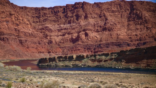
Text
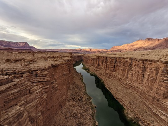
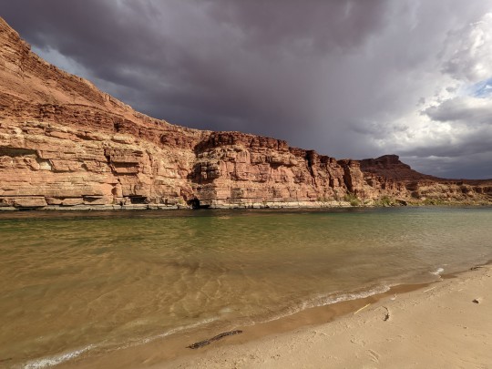
Marble Canyon and Paria Beach in Arizona
#glen canyon national recreation area#arizona#page arizona#colorado river#vermillion cliffs national monument
5 notes
·
View notes
Text
Vermillion Cliffs National Monument
328 notes
·
View notes
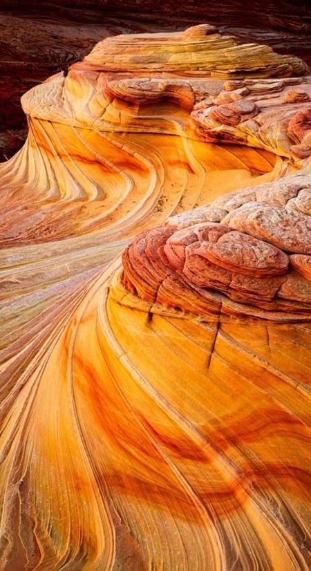
Text
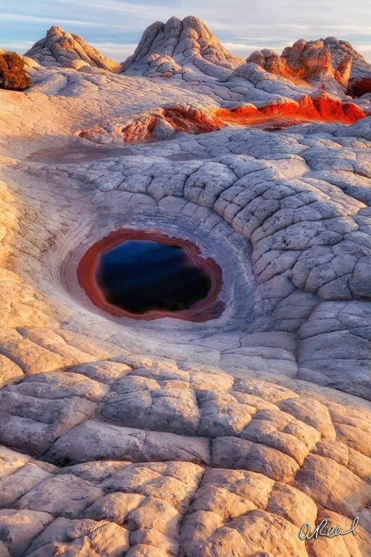
"Sleeping dragon eye" at White pockets, Vermillion Cliffs National Monument, Arizona, United States.
Over time, a smooth basin has gradually been eroded into the stone within the undulating landscape of pillowed rocks at White pockets. An inky pool of captured rainwater creates the illusion of a "dragon eye" and this dark liquid mirror seems to be bottomless and hiding mysteries.
📷 Aaron Reed Photography
106 notes
·
View notes
Text

Vermillion Cliffs National Monument, Arizona, USA
47 notes
·
View notes
Photo

Vermillion Cliffs National Monument, Arizona, USA
📸 by Jessica Fridrich
22 notes
·
View notes
Photo

Vermillion Cliffs National Monument, AZ, USA [3000x2247] [OC] https://ift.tt/ROryH1Q
1 note
·
View note
Photo
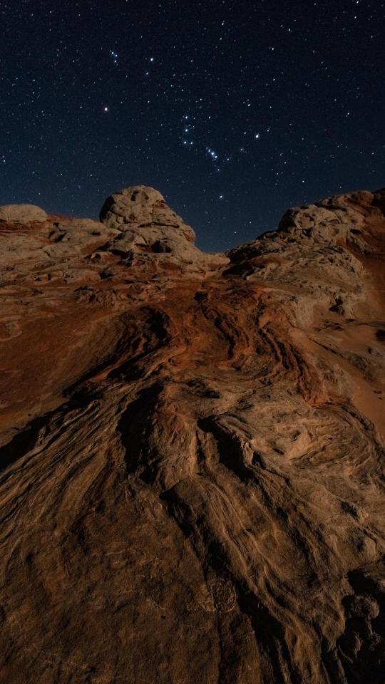
Orion at White Pocket, Vermillion Cliffs National Monument, Arizona, USA [OC] 1920 x 1080
9 notes
·
View notes
Photo
The White Pocket in Vermillion Cliffs National Monument. It is near the Arizona and Utah border.
3 notes
·
View notes
Text

#lees ferry#glen canyon national recreation area#vermillion cliffs national monument#adventure#travel#my photo#southwest#desert#arizona#photography#aesthetic#landscape#nature
162 notes
·
View notes
Photo

2022 : Rainbow Ridge [Road Trip Day 08]
Along Vermillion Cliffs National Monument, AZ.
5 notes
·
View notes
Text
[ad_1]
Grand Staircase Escalante is a rugged wilderness of colourful rock, slot canyons, exciting driving, and stunning hikes. Our guide to the area includes all the best things to do and where to stay.
LAST UPDATE: 18 Jan 2024
Anywhere We Roam is reader-supported. When you buy through links on our site, we may earn a small affiliate commission at no extra cost to you. Thanks for your support - Paul & Mark.
Grand Staircase Escalante is 1.9 million acres of wilderness.
At its western edge, a dramatic staircase of vivid cliffs change colour as they steadily climb. In the east, the Escalante River and its tributaries cut through red sandstone creating slot canyons and natural arches.
In between, a high plateau is an adventure playground with rough tracks for 4×4 excursions.
This is remote Utah. Come here for adventurous hiking, an exhilarating road trip or an escape in an under-explored natural wilderness.
These are all our favourite things to do in the Grand Staircase Escalante National Monument. We cover the layout of the park, a map of the region, and advice about where to stay.
HOLE IN THE ROCK ROAD
WHAT IS GRAND STAIRCASE ESCALANTE NATIONAL MONUMENT?
Grand Staircase Escalante is a rugged wilderness in the state of Utah in the USA. In 1996 it was designated a National Monument by President Bill Clinton. Covering 1.9 million acres it was the largest National Monument (area of significant natural, cultural, historical, or scientific importance) in the United States.
Its designation was always controversial and in 2017 President Trump reduced the size of the monument by half. It was restored to its original size in 2021 by President Biden.
LAYOUT OF GRAND STAIRCASE ESCALANTE NATIONAL MONUMENT
The National Monument consists of three distinct landscapes:
GRAND STAIRCASE
In the west is the Grand Staircase. This aptly named area is a series of colourful cliffs and terraces that rise step-like from Grand Canyon in the south to Bryce Canyon in the northwest. As the staircase rises, the cliff colours change from chocolate to vermillion, white to gray, and finally to pink.
KAIPAROWITS PLATEAU
In the centre is the Kaiparowits Plateau. This high plateau is a slice of green amongst the predominately red rock. The green is the pinyon-juniper woodland that clings to the high elevation. It is a very remote area and not many people visit here.
ESCALANTE CANYONS
In the northeast are the Escalante Canyons. This is where tributaries of the Escalante River cut through the red rock to create slot canyons, arches, sculpted slickrock and waterfalls. It is a haven for adventurous hikers.
ESCALANTE CANYONS
SPOOKY SLOT CANYON
MAP | GRAND STAIRCASE ESCALANTE NATIONAL MONUMENT
You can find a broad outline of the different areas of Grand Staircase in our map below.
Grand Staircase – blue
Kaiparowits Plateau – green
Escalante Canyons – red
The National Monument is accessible via two main roads. Highway 12 (which is stunning) runs through the northern section, while Highway 89 runs through the southern section.
The only reasonable road within the National Monument that connects the two main roads is Cottonwood Canyon Road. It is unpaved and can be impassable after rain (purple on map).
>
How to use this map / Click on the top left of the map to display the list of locations, then click on the locations to display further information. Click on the top right corner of the map to open a larger version in a new tab or the star to save to your Google Maps.
HEAD OF THE ROCKS OVERLOOK, HIGHWAY 12
What to do in Grand Staircase Escalante National Monument
ESCALANTE CANYONS
1. DRIVE HIGHWAY 12
Often listed as one of the most stunning roads in the country, the All-American Scenic Highway 12 reaches its zenith between the towns of Boulder and Escalante.
Leaving Boulder, the road runs along a narrow ridge called the Hogback. The road twists and turns as a dramatic canyon drops below. The red and white rock contrasts beautifully with the green oasis that lies along the canyon bottom.
It’s a beautiful drive.
Don’t miss the Head of the Rocks Overlook which offers great views over the road as it cuts through the red and white rock. Kiva Koffeehouse is an atmospheric spot for a break.
HIGHWAY 12
ESCALANTE CANYONS
2. HIKE TO LOWER CALF CREEK FALLS
Roughly halfway along the Hogback the road passes Calf Creek Falls. Deep down in the canyon the falls are split into the Upper and Lower Calf Creek Falls. The hike to the Lower Falls is one of the best hikes in the Grand Staircase Escalante National Monument.
The hike is 3 miles each way (6 miles in total) and leaves from the well signed Lower Calf Creek Falls Trailhead ($5 per vehicle). The trail runs beside Calf Creek as it winds along the bottom of the canyon. It’s a straight-forward walk although part of it is on sand.
The Lower Calf Creek Falls is a slender 126-foot-high cascade plunges into a lovely pool. It’s an excellent place for a refreshing dip so bring your swimming gear.
Allow 3-4 hours for the round-trip hike and swim. There are no changing rooms at the falls but there are restrooms at the trailhead.
CALF CREEK FALLS HIKE
ESCALANTE CANYONS
3. ANASAZI STATE PARK MUSEUM
The Ancestral Puebloans that inhabited this region over 1,000 years ago are often referred to as Anasazi. The goal of this museum ($5) is to preserve their cultural heritage.
The highlight is the Puebloan remains of Coombs Village. Dating back to the 12th century, you can explore the partially reconstructed structures and kivas (subterranean ceremonial room).
Outside the museum there’s a completely reconstructed six-room replica of the ancient dwelling. Inside there are a mix of artefacts from the site.
In the parking lot, we highly recommend Magnolia’s food truck which does an excellent lunch.
ESCALANTE CANYONS
4. DRIVE THROUGH LONG CANYON ON THE BURR TRAIL
The Burr Trail (marked in brown on the map above) is a paved road that runs along the northern eastern edge of the Escalante Canyons.
As it winds across the barren rugged landscape it crosses two tributaries that have cut pretty canyons through the rock.
The first is Lower Deer Creek which deserves a quick stop.
The second is Long Canyon and it’s far more spectacular. The Gulch, a major tributary of the Escalante River, has cut a remarkable slot canyon through the rock.
The road passes through Long Canyon with walls of red rock rising on either side.
Half-way along Long Canyon, there is an offshoot called Singing Canyon with incredible natural acoustics. Next, stop off at the Long Canyon Overlook before returning the way you came.
Long Canyon is a 30-minute detour off Highway 12 in Boulder (1-hour return).
TIP | BURR TRAIL TO CAPITOL REEF
It’s possible to follow the Burr Trail all the way to Capitol Reef National Park (one of the Might 5 National Parks of Utah), but you’ll need a sense of adventure.
After leaving Grand Staircase Escalante National Monument the paved road ends and becomes a rough gravel track. It descends the Waterpocket Fold switchbacks and then meets the Notom-Bullfrog Road.
Expect it to take most of the day but check conditions with park management before setting off. Don’t attempt after rain.
BURR TRAIL
CAPITOL REEF
ESCALANTE CANYONS
5. DRIVE HOLE-IN-THE-ROCK ROAD
The Hole-in-the-Rock Road (marked in red on the map) is a rough track that runs along the western edge of the Escalante Canyons section of the park. It is the access road to the most dramatic slot canyons in the area.
Even if you don’t visit the canyons, it’s worth driving down here. Cliffs rise on your right-hand side as strange rock formations appear near the road. The most dramatic is Devil’s Garden, where red and sandy-coloured hoodoos rise above the desert landscape.
The Hole-in-the-Rock Road is rough but can usually be driven in a normal 2WD to Devils Garden (12 miles – 30 minutes) and to Lower Dry Fork Trailhead (26 miles – 50 minutes).
After that the road gets progressively tougher and you’ll
need a high clearance 4×4 to reach Hole-in-the Rock on the Western Shores of Lake Powell (55.5 miles – 2 hours 30 minutes).
DEVIL’S GARDEN
ESCALANTE CANYONS
6. HIKE ZEBRA SLOT CANYON
A slot canyon is a long, narrow channel with sheer smooth-sided rock walls. Formed as water flows through sandstone or sedimentary rock, they are one of the highlights of Grand Staircase Escalante.
Antelope Canyon, in nearby North Arizona, is probably the most famous slot canyon in the world. But you need to join an organised tour to see it. In Escalante you can enjoy this unforgettable experience on your own.
Zebra Slot Canyon is a short but very pretty slot canyon with stripey horizontal lines running along the slick walls.
The problem is that It requires a 5.2-mile out and back hike (3 to 4 hours) and the canyon often has standing water which means you must be prepared to get wet. The trailhead is 8 miles (15 minutes) down Hole-in-the-Rock Road.
In our opinion, it’s better to visit Dry Fork, Peekaboo and Spooky Slot Canyons. Coming up next.
ESCALANTE CANYONS
7. HIKE PEEKABOO & SPOOKY SLOT CANYONS
Lower Dry Fork Trailhead is 26 miles (50 minutes) down Hole-in-the-Rock Road. It is the starting point for exploring three very different canyons making it one of the best hikes in Grand Staircase Escalante.
From the trailhead (with WC) follow the path as it winds along the top of the canyon wall. Then follow the cairns as they drop diagonally down the canyon wall. Be careful as the rock can be a little slippery.
The path then descends across the sand to the bottom of the canyon. (Marked with black dot on map above).
Turn left and explore Dry Fork Narrows. This canyon is wider than the others and easier to walk along. Head as far as you want before returning.
Next explore Peekaboo Slot Canyon. This is a great slot canyon, but the challenge is getting in. The entrance is a 12-foot scramble up a rocky wall. Some steps have been carved into the rock, but it’s still tricky. Once inside walk on the sweeping walls, crouch under the arches, and navigate the cylindrical pockets.
Finally explore Spooky Slot Canyon. This is not one for the claustrophobic. The slick rock walls get tighter and tighter, making it more and more difficult to move. At one point it’s just 10 inches wide.
SPOOKY
SPOOKY
SPOOKY
ESCALANTE
PEEKABOO + SPOOKY LOOP
You can walk Peekaboo and Spooky individually (out and back) or combine them in a 1.7-mile loop. If you choose the loop, park authorities ask all hikers to walk in one direction. Head up Peekaboo, then after exiting at the top, follow the cairns to the top entrance to Spooky, then walk back down Spooky into the main canyon.
Be aware that midway down Spooky Canyon there is a 10-foot drop aided by a rope, if you don’t fancy it, you can avoid it by doing each canyon as an individual hike.
Allow 2 hours for the drive there and back and 3 to 4 hours to explore the canyons. Do not attempt if rain is forecast as slot canyons can be dangerous.
GRAND STAIRCASE
8. KODACHROME BASIN STATE PARK
Kodachrome Basin State Park ($10 per vehicle) is known for its distinctive sandstone chimneys and spires that rise up to 170 feet in the air. The rock is a striking mix of red, orange, pink and white. The vibrant colours lead the National Geographic Society to name the park after the popular Kodak colour film.
Simply drive around the park and stop at whichever formation grab your attention.
Strictly speaking Kodachrome State Park is not in Grand Staircase Escalante National Monument, but it is surrounded by it on all sides so it may as well be.
KODACHROME BASIN
GRAND STAIRCASE
9. DRIVE COTTONWOOD CANYON ROAD
The only reasonable road that cuts across the Grand Staircase from north to south is THE 46-mile-long Cottonwood Canyon Road. It’s a great way to get between Highway 12 and Highway 89 without completing a big loop of motorways.
From Highway 12 it begins as a paved road, but once it passes Kodachrome Basin State Park it turns to gravel.
The scenery along the 90-minute journey is excellent and can usually be completed in a 2WD car (although not after rain when it is impassable even in a 4×4).
Be sure to stop at Grosvenor Arch, a double arch a short detour from the main Cottonwood Canyon Road.
BACKCOUNTRY, ESCALANTE
GRAND STAIRCASE
10. COYOTE BUTTES NORTH
Just over the southern border of Grand Staircase Escalante National Monument is Coyote Buttes North. Officially part of the Praia Canyon – Vermilion Cliffs Wilderness it has two exceptional sights.
BUCKSKIN GULCH
Buckskin Gulch is the longest and deepest slot canyon in the Southwest and offers obstacles like ladders, rock jams, quicksand, and pools. It’s 1.7 miles from Wire Pass Trailhead to the entrance to the gulch. Simply walk into the gulch for as long and as far as you can before turning around. Day Permit required, usually obtainable online on the day.
THE WAVE
The Wave is a mesmerising geological formation of undulating swirling patterns in the sandstone rock. Pictures of it look truly staggering. Unfortunately, access is extremely limited and you must be very lucky to get a permit. We applied 5 times without success.
There’s an advanced lottery around 4 months in advance and a daily lottery 1 day in advance. Try your luck on blm.gov and If you manage to get a permit, please send us a photo!
BUCKSKIN GULCH
PERMITS
There is no fee to enter the Grand Staircase Escalante National Monument and no permits are required for day trips into the park. If you intend to spend the night camping in the monument you will need a Backcountry Camping Permit.
Permits are required to hike in Coyote Buttes North.
GRAND STAIRCASE ESCALANTE VISITOR CENTER
It’s a good idea for first-time visitors to go to one of the four visitors’ centers in the park. Ask about road, trail, and weather conditions especially if you plan to hike in the slot canyons and drive the backcountry roads.
There are helpful maps that can be picked up outside the visitors’ centres, even if it’s closed.
The visitors’ centres are at Big Water, Cannonville, Escalante and Kanab.
BIG WATER VISITOR CENTER
WHEN TO VISIT
The best time to visit Grand Staircase Escalante are in the shoulder seasons of spring and fall. May, June, and September have the least amount of rain making these months the best time to hike in the slot canyons.
In July and August, temperatures often reach 95 – 105°F making day hikes and exploration challenging.
In winter the region is cold and windy with temperatures going below freezing. Snow can cover the higher elevation areas and with increased rain many of the unpaved roads are unpassable.
WHERE TO STAY
Most of the attractions in Grand Staircase Escalante are best accessed from Highway 12 in the northern section of the National Monument. The most convenient base is Escalante Town which has a gas station, a few restaurants, a grocery store, outfitters, RV park, and a bar.
Here are a couple of hotel recommendations.
OUR PICK
ESCALANTE TOWN
THE INN OF ESCALANTE
Large comfortable adult-only rooms in the centre of town. The owner, Tom, was full of tall stories, and helpful advice for the day ahead.
BOOKING.COM | HOTELS.COM
WHERE TO STAY IF YOU HAVE TICKETS FOR THE WAVE
If you are lucky enough to get a permit for The Wave, stay in either Kanab or Page.
To do the wave, you need to physically attend a Bureau of Land Management Office to pick up your permit and watch a safety briefing. These centres are in Kanab and Page and both are around 1 hour’s drive from the trailhead.
WHERE NEXT AFTER ESCALANTE
Grand Staircase Escalante is next to 5 stunning National Parks in Utah known as the Mighty 5. All can be explored on a wonderful 2-week US road trip that includes Las Vegas, Grand Canyon & Monument Valley.
Here are our recommendations on how to see it all:
ANYWHERE WE ROAM ISREADER-SUPPORTED
Thanks for reading. To support our blog, you can shout us a coffee or follow us on social media. Big thanks – Paul & Mark.
INSTAGRAM | FACEBOOK
[ad_2]
Source link
0 notes
Text
Grand Canyon National Park

The Grand Canyon's Hidden Gems Secret Spots Discovered On Rafting Adventures
Welcome to the breathtaking splendor of the Grand Canyon, where each glance holds a new marvel that tugs at the soul. Places not marked by the footsteps of the many but reserved for those who travel via river are enclaves of tranquility surrounded by wild nature, ready to make your adventure truly one for the books.
What Are Some Of Grand Canyon's Top Hidden Gems?
The Grand Canyon National Park is famous for its majestic views and hidden gems, often overlooked by visitors. From the North Rim to Marble Outlook and Lake Mead, unique spots are waiting to be discovered in this iconic national park, whether visiting solo or bringing your whole family. Contact Advantage Grand Canyon today to search for rafting trips from all the top 15 outfitters in one place and book your next Grand Canyon rafting trip!
The North Rim
We explore the North Rim, a refreshing retreat from the often-crowded South Rim. Unlike the South Rim, this area boasts lush forests and rare wildlife sightings, creating an entirely different Grand Canyon experience. Trails here are less traveled, allowing us to immerse ourselves in nature without battling throngs of tourists. Reaching the North Rim feels like discovering a hidden part of Grand Canyon National Park that few see. Its unique ecosystem is home to species not found on other rims. It allows us to encounter unexpected plant and animal life while hiking or camping nearby (the Bright Angel campground is a good example). The majestic views attract photographers and adventurers alike but retain an air of tranquility that makes every visit feel special and undisturbed by the outside world.
Marble Outlook
Our journey through the Grand Canyon's vast landscape isn't complete without a visit to Marble Outlook. Nestled in Kaibab National Forest, this camping area unveils sweeping vistas of House Rock Valley and the captivating hues of Vermillion Cliffs National Monument. Imagine waking up to the sunrise painting colors over Paria Canyon Wilderness; it's a sight that etches itself into memory. You'll find yourself entranced by Marble Outlook, where every glance offers another stunning angle of the canyon’s grandeur.
Diamond Creek Road
Moving on from the breathtaking views at Marble Outlook, we find ourselves navigating Diamond Creek Road, a unique passage that carves its way into the vastness of the Grand Canyon. This road is an exclusive byway where you can drive your vehicle down into one of nature's most awe-inspiring landscapes with the necessary permit. Here, adventurers get to experience up-close encounters with ancient rock formations and gain entry to exclusive river trips offered by no other than the Hualapai Tribe.
Havasupai Falls
Tucked away within the Havasupai Indian Reservation lies Havasupai Falls, a breathtaking sight with cascading waters that plunge into stunning blue-green pools. We'll find ourselves mesmerized by this oasis, often nicknamed the "Shangri-la" of the Grand Canyon. The vibrant hues result from high levels of calcium carbonate in the water—a natural phenomenon worth witnessing. Our journey to these falls offers more than just a visual treat; it's an invitation to dip into nature’s swimming pools carved over centuries by flowing waters.
Top Secret Spots Discovered At The Colorado River
Venture into the solitude of the Tonto Trail, find a secret cave behind a waterfall, and witness a spectacular hidden Grand Canyon view that will leave you in awe. Discover these amazing hidden gems waiting for you on your next rafting adventure.
Solitude of the Tonto Trail
Hiking along the Tonto Trail allows us to experience peace and tranquility amidst the grandeur of the Grand Canyon. This trail runs parallel to the Colorado River, offering stunning scenery and a sense of seclusion away from the more crowded areas. The Tonto Trail allows one to explore the canyon's beauty while enjoying a quieter environment. With its breathtaking vistas and serene atmosphere, this trail offers a unique way to connect with nature and appreciate the remarkable features of the Grand Canyon.
Secret Cave Behind a Waterfall
During our exhilarating Grand Canyon rafting adventures, we stumbled upon a true gem that left us in awe - the secret cave behind a breathtaking waterfall. This remarkable discovery unfolded before us as we navigated through the winding waterways. The grandeur of the cascading waters veiled an enchanting cavern, inviting us to explore its mysteries. Our sense of adventure soared as we entered this clandestine sanctuary nestled behind the majestic veil of rushing water.
Spectacular Secret Grand Canyon View
Embark on a thrilling rafting adventure through the Grand Canyon to discover an awe-inspiring secret view. As we navigate the Colorado River, a remarkable hidden cave behind a breathtaking waterfall awaits us. This stunning natural wonder provides an unforgettable vantage point of the majestic canyon landscape, offering a unique and mesmerizing perspective that intrepid explorers can only access.
Unique Attractions in the Grand Canyon Area
Experience the unique beauty of The Crack at Wet Beaver Creek, where you can marvel at the stunning natural formations. Explore Labyrinth Canyon's enchanting pathways and immerse yourself in the mesmerizing surroundings.
The Crack at Wet Beaver Creek
The Crack at Wet Beaver Creek, situated southeast of Sedona, beckons with its local swimming hole attractions. Visitors can indulge in cliff jumping, swimming, and wading activities while relishing the natural beauty. With no required fees or permits to visit The Crack, enthusiasts can embark on a 3.5-mile hike from the Bell Trailhead and revel in the surrounding tranquility. However, it's crucial to note that weekends and holidays witness increased foot traffic for this hidden gem, prompting overflow parking at the Bruce Brockett trailhead.
Labyrinth Canyon
Moving on from The Crack at Wet Beaver Creek, another hidden gem worth exploring on a Grand Canyon rafting trip is Labyrinth Canyon. Accessible only by stand-up paddleboard or kayak, this secluded slot canyon offers a serene and uncrowded alternative to the famous Antelope Canyon. With its mesmerizing rock formations and tranquil atmosphere, Labyrinth Canyon provides an opportunity for an off-the-beaten-path adventure surrounded by stunning natural beauty. Labyrinth Canyon stands out as we continue our journey through the secret spots of the Grand Canyon area. It is a must-visit destination for those seeking a unique and peaceful experience away from the crowds.
Watson Lake: Prescott, AZ
Nestled in the pristine beauty of Prescott, Arizona, Watson Lake offers a unique blend of granite formations and outdoor recreational activities. The reservoir, formed by damming Granite Creek in the early 1900s for irrigation purposes, is now a haven for fishing, hiking, biking, canoeing, kayaking, boating, and bouldering enthusiasts. Visitors can explore the surrounding hiking trails, including a scenic 4.8-mile loop and access to the Peavine National Recreational Trail. For just a $3 per vehicle parking fee at Watson Lake Park, visitors can enjoy amenities such as picnic areas and a playground for children to enjoy along disc golf courses and campsites surrounded by stunning natural beauty.
Contact Advantage Grand Canyon today to search for rafting trips from all the top 15 outfitters in one place and book your next Grand Canyon rafting trip!
#https://www.advantagegrandcanyon.com/grand-canyon-hidden-gems-rafting-adventures/#grand canyon hidden gems#grand canyon rafting adventures#grand canyon national park#grand canyon rafting trip#colorado river rafting#grand canyon experience#rafting adventure#grand canyon#rafting trips#advantage grand canyon#AdvantageGrandCanyon#advantagegrandcanyon.com
0 notes
Text
The Wave, Vermillion Cliffs National Monument, Arizona
Step into a world of awe-inspiring wonder at The Wave, a hidden gem within the splendid Vermillion Cliffs National Monument in Arizona.
0 notes
Last Seen Blogs