#aerial surveys
Text
GMap LLC: Delivering Precision Land Surveying Solutions Across Oman & Dubai

GMap LLC, a leading survey company headquartered in Muscat, Oman, is your trusted partner for all your land surveying needs. We offer a comprehensive suite of services designed to deliver accurate and efficient results across various sectors, from construction and engineering to real estate and environmental management.
Unmatched Expertise in Land Surveying:
At GMap LLC, land surveying is our core competency. Our team of highly qualified and experienced land surveyors boasts extensive knowledge and utilizes cutting-edge technology to ensure the highest level of precision in every project. We employ a variety of land surveying techniques to cater to your specific requirements, including:
3D Laser Scanning: Create detailed 3D models of your site for construction planning, volume calculations, and accurate topographic maps.
Total Stations and GPS: Employ traditional surveying methods with advanced equipment for precise boundary demarcation, stakeout, and topographical data collection.
Drone Surveys: Leverage the power of drone technology for cost-effective and time-saving aerial surveys, generating high-resolution orthomosaics and digital elevation models (DEMs) for large-scale projects.
Beyond Land Surveying: A Full Spectrum of Services
GMap LLC goes beyond traditional land surveying. We offer a variety of services to meet your project's specific needs:
Road & Pipeline Corridor Surveys: Ensure accurate alignment and minimize construction challenges with detailed corridor surveys for roads, pipelines, and other linear infrastructure projects.
GPR (Ground Penetrating Radar): Locate and map underground utilities and structures with non-destructive GPR technology, promoting safety and efficiency during excavation projects.
Bathymetry Surveys: Gain a comprehensive understanding of underwater terrain features for harbor development, coastal management, and marine infrastructure projects.
Topographic Surveys: Create detailed topographic maps that depict the elevation and other physical features of your land, crucial for site planning and development.
GIS Mapping & Spatial Analysis: Leverage Geographic Information Systems (GIS) to transform spatial data into insightful maps and reports, aiding informed decision-making.
Mine & Archeological Surveys: Employ specialized surveying techniques for precise mapping of mine sites and archeological features, ensuring preservation and accurate data collection.
Why Choose GMap LLC for Your Land Surveying Needs?
Precision & Accuracy: We prioritize meticulous data collection and processing, guaranteeing the highest level of accuracy in your land survey results.
Advanced Technology: We stay at the forefront of surveying technology, ensuring efficient data acquisition and analysis for faster project completion.
Experienced Professionals: Our team of qualified land surveyors possesses the expertise to tackle even the most complex land surveying projects.
Cost-Effectiveness: We work closely with clients to understand their budget constraints and provide cost-effective solutions without compromising quality.
Complete Service Package: We offer a comprehensive service package, including data collection, processing, analysis, and detailed reports tailored to your project requirements.
Regional Expertise: GMap LLC caters to clients across Oman and Dubai, UAE, providing our expertise and resources throughout the region.
Investing in a Precise Land Survey with GMap LLC
By choosing GMap LLC, you gain a reliable partner committed to accuracy, efficiency, and exceeding your expectations. Our expertise and advanced technology ensure you receive the most valuable data to make informed decisions throughout your project lifecycle.
1 note
·
View note
Text
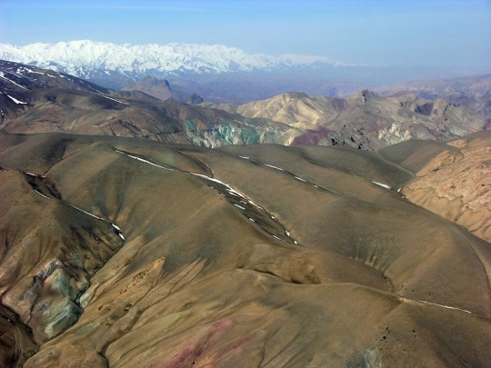
Colorful Mountains
Colorful Mountains — Look closely at this aerial shot of the colorful mountain ranges in Sar-e Pol, Afghanistan and you'll see hints of copper (the green) and iron (the red).
By U.S. Geological Survey
#us geological survey#photographer#flickr#mountains#sar-e pol#afghanistan#landscape#aerial photography#nature#copper#iron
14 notes
·
View notes
Text
This is simply astounding. So. Many. Sites. Incredible.
21 notes
·
View notes
Text
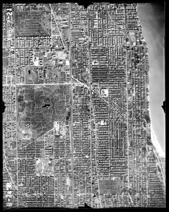
1939 Aerial Photo of the Edgewater area.
The lakefront extension and Lake Shore Drive hasn't gotten past Foster Avenue yet. At left of center is Rosehill Cemetery, and to it's east is Senn High School, it's north wing not yet built. To the south of Rosehill is Winnemac Park with Amundsen High and Chappell Elementary. The prominent shadows at the lake front are the towers of the Edgewater Beach Hotel complex. At the upper left is the former Edgewater Golf Club, now Warren Park. At lower right is St Boniface Cemetery, and the Uptown Theater.
3 notes
·
View notes
Text
What Is Aerial Infrastructure 3D Planning?
Aerial infrastructure 3D planning is detailed planning of urban development. A detailed study is done to plan development and every care is taken to make sure that the development work is carried out without disturbing the environment. It starts with accurate measurement of the land where development is planned and the land is surveyed with 360-degree images.
Visit us - https://kavmedidaseo.blogspot.com/2024/08/what-is-aerial-infrastructure-3d.html
#aerial scanning#aerial photogrammetry services#aerial 3d mapping#land surveying#drone surveying#mobile 3d mapping#surveying companies
0 notes
Text
Optimizing Ground Sample Distance (GSD) with Drones
Drones are increasingly employed to measure Ground Sample Distance (GSD) by capturing high-resolution aerial images from different altitudes. GSD represents the distance between the centers of two adjacent pixels in an image, usually measured in centimeters per pixel. As the drone flies lower, the GSD decreases, leading to more detailed imagery. Accurate GSD is essential for applications such as mapping, surveying, and precision agriculture, where detailed and precise data is critical.
https://dynatech.ae/
0 notes
Text
सीएम पुष्कर धामी ने आपदाग्रस्त क्षेत्रों का किया हवाई सर्वेक्षण, कहा, जल्द शुरू होगी चारधाम यात्रा
Uttarakhand News: मुख्यमंत्री पुष्कर सिंह धामी ने बाढ़ प्रभावित क्षेत्रों में जनजीवन सामान्य बनाने के लिए आवश्यक कदम उठाने के निर्देश देते हुए कहा कि क्षतिग्रस्त मार्गाें, पेयजल और विद्युत लाइनों को यथाशीघ्र बहाल किया जाए। उन्होंने केदारनाथ पैदलयात्रा मार्ग शीघ्र शुरू करने और हेली सेवा बुधवार से ही शुरू करने के निर्देश दिए।
उन्होंने ऐलान किया हेलीकॉप्टर यात्रा की टिकटों में 25 फीसदी छूट राज्य…
0 notes
Text
#Aerial Mapping Drones#drones#survey drone#Land Surveying#Drone Surveying Applications#Drone Surveying Techniques
0 notes
Text
aerial survey company in india
Introduction
In recent years, the landscape of surveying and inspection has transformed dramatically with the advent of drone technology. As industries across the globe recognize the efficiency and precision offered by drones, India is no exception. The country has seen a surge in demand for drone-based services, making it imperative to understand the benefits and applications of this cutting-edge technology. In this article, we will delve into the various aspects of drone surveys and inspections, focusing on their significance and the leading aerial survey companies in India.
## The Evolution of Aerial Surveying in India
Aerial surveying has traditionally involved manned aircraft, which are costly and less efficient. However, the integration of drones into this field has revolutionized the way surveys are conducted. An aerial survey company in India can now provide detailed and accurate data in a fraction of the time and cost compared to conventional methods.
### Advantages of Drone Surveys
1. **Cost-Effectiveness**: Utilizing drones significantly reduces the expenses associated with manned aircraft, fuel, and personnel.
2. **Accuracy**: Drones equipped with advanced sensors and cameras capture high-resolution images, ensuring precise data collection.
3. **Safety**: Drones can access hazardous or difficult-to-reach areas without putting human lives at risk.
4. **Speed**: The rapid deployment and operation of drones allow for faster data acquisition and processing.
## Drone Inspection in India: A Game Changer
Drone inspection in India has gained traction across various sectors, including infrastructure, agriculture, and energy. These inspections help identify potential issues before they escalate, ensuring timely maintenance and repairs.
### Key Applications of Drone Inspections
1. **Infrastructure Monitoring**: Drones are used to inspect bridges, roads, and buildings for structural integrity, detecting cracks, corrosion, and other damages.
2. **Agricultural Assessments**: In agriculture, drones monitor crop health, identify pest infestations, and assess irrigation systems, leading to optimized farming practices.
3. **Energy Sector**: Drones inspect power lines, wind turbines, and solar panels, identifying faults and enhancing the efficiency of energy production and distribution.
## Leading Drone Survey Companies in India
The increasing demand for drone surveys has led to the emergence of several drone survey companies in India. These companies offer a range of services, from topographic surveys to aerial inspections.
### Garud Survey: Pioneering Drone Technology
One prominent drone survey company in India is Garud Survey. With a commitment to excellence and innovation, Garud Survey provides comprehensive drone survey and aerial inspection services. Their expertise spans various industries, ensuring tailored solutions for each client's unique needs.
[Explore Garud Survey's Services](https://garudsurvey.com/)
## Drone Survey and Aerial Inspection: A Synergistic Approach
Combining drone surveys with aerial inspections offers a holistic approach to data collection and analysis. This synergy enhances the overall efficiency and accuracy of projects, making it a preferred choice for many industries.
### Benefits of Integrated Drone Services
1. **Comprehensive Data**: Integrating surveys and inspections provides a complete picture, facilitating informed decision-making.
2. **Enhanced Efficiency**: Coordinating both services reduces redundancy and streamlines operations.
3. **Improved Accuracy**: Cross-referencing data from surveys and inspections ensures higher precision and reliability.
## Drone Topographic Survey: Mapping the Future
Drone Topographic surveys are essential for various applications, including construction, land development, and environmental studies. Drones have revolutionized topographic surveying by providing detailed and accurate maps quickly and efficiently.
### Applications of Drone Topographic Surveys
1. **Construction Planning**: Detailed topographic maps assist in site planning, design, and construction, minimizing risks and optimizing resource allocation.
2. **Land Development**: Accurate terrain data is crucial for land development projects, ensuring compliance with regulations and efficient land use.
3. **Environmental Monitoring**: Drones help monitor natural habitats, assess environmental impact, and support conservation efforts.
## Conclusion
The integration of drone technology in surveying and inspection has marked a new era of precision, efficiency, and safety. As the demand for these services continues to grow, companies like Garud Survey are at the forefront, providing innovative solutions tailored to the unique needs of various industries. Whether it's an aerial survey, drone inspection, or topographic mapping, the future of surveying in India is undeniably airborne.
To learn more about the transformative power of drones and explore the services offered by a leading aerial survey company in India, visit [Garud Survey](https://garudsurvey.com/). Embrace the future of surveying and inspection with cutting-edge drone technology.
---
By integrating the keywords seamlessly throughout the article, we ensure optimized search engine performance while providing valuable information to the readers. If you have any specific requirements or additional details to include, please let me know!
0 notes
Text
Aerial Surveying
Aerial surveying revolutionizes construction site management by providing detailed, accurate data from an elevated perspective. Using drones and advanced imaging technology, it captures high-resolution images and topographic information, allowing for precise planning and monitoring. This method enhances efficiency, reduces costs, and improves safety by identifying potential issues early. Embracing aerial surveying means staying ahead in the industry, ensuring projects are completed on time and within budget. Discover the transformative impact of aerial surveying on construction efficiency.
Visit Now-https://medium.com/@aussiehydrovacservices/improving-the-efficiency-of-construction-sites-using-aerial-and-construction-site-surveying-902ec4e68bce
#Aerial Surveying#industrial cleaning service#industrial drain cleaning#industrialdraincleaning#liquid waste removal
0 notes
Text
#GIS Mapping Survey in India#GIS Mapping Survey#GIS Mapping Company in India#Geographic Information System#Drone Survey#aerial photography survey#aerial survey
0 notes
Text
Drone Inspection in India: Professional Aerial Surveys and Inspections
With our drone inspection in India, we offer professional aerial surveys and inspections that provide a cost-effective and efficient solution for various industries. Our experienced team utilizes cutting-edge technology to capture high-quality images and data for in-depth analysis, helping businesses make informed decisions based on accurate information. Trust us for reliable drone inspection services that deliver results you can count on.

0 notes
Text
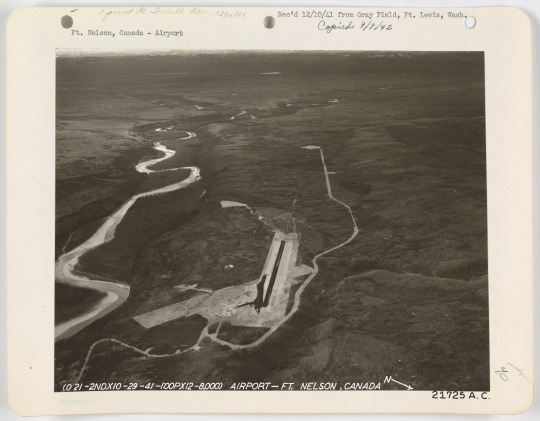
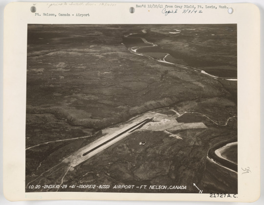
Fort Nelson Airfield, 1941
#Fort Nelson#Fort Nelson BC#British Columbia#airfield#1940s#1941#survey photo#aerial photo#photography#places#hide and queue
1 note
·
View note
Link
Drone surveying is an aerial survey conducted using drones and special cameras to capture aerial data with downward-facing sensors. Drone survey, also known as unmanned aerial vehicle (UAV) surveying or
aerial Photography survey
, involves the use of drones equipped with various sensors to collect data for mapping, monitoring, and analyzing landscapes. This technology has gained widespread popularity due to its efficiency, cost-effectiveness, and versatility in various industries.
Key Features of Drone Survey:
High-resolution Imaging: Drones are equipped with high-resolution cameras that capture detailed images of the survey area. This allows for the creation of accurate and visually rich maps.
LiDAR Technology: Light Detection and Ranging (LiDAR) sensors on drones provide 3D mapping capabilities by measuring distances with laser light. This enables precise terrain modeling and elevation mapping.
GPS Technology: Integrated GPS systems enable accurate georeferencing of collected data. This ensures that the mapping and surveying results are spatially accurate.
Multispectral and Thermal Imaging: Drones can be equipped with multispectral and thermal cameras, allowing for the collection of additional data beyond visible light. This is particularly useful in agriculture for monitoring crop health and identifying irrigation issues.
Autonomous Flight and Waypoint Navigation: Drone surveying often involves the use of autonomous flight technology. Drones can follow predefined waypoints, optimizing the survey process and ensuring consistent data collection.
Real-time Data Transmission: Some advanced drones have the capability to transmit data in real-time. This allows for on-the-fly analysis and immediate decision-making based on the survey results.
1 note
·
View note
Last Seen Blogs

arthurfleck-tiemeup
♡ Arthur Fleck's Angel ♡

istoredubaidu
Istoredubaidu


aftrprty
YAM$

arunika-sy
arunika