#bay of biscay
Text

The furious action between H.M.S. Mars and the French '74 Hercule off Brest on 21st April 1798
by John Christian Schetky
#john christian schetky#art#battle of the raz de sein#duel#age of sail#marine art#royal navy#england#great britain#france#history#europe#french revolutionary wars#hercule#hms mars#naval battle#naval warfare#alexander hood#louis lhéritier#english#british#french#bay of biscay#warship#warships#ships#clouds#moonlight#moonlit#sea
45 notes
·
View notes
Photo
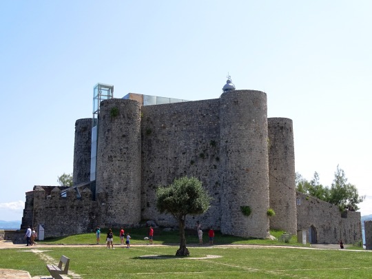


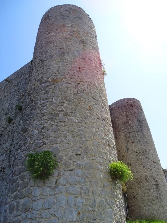
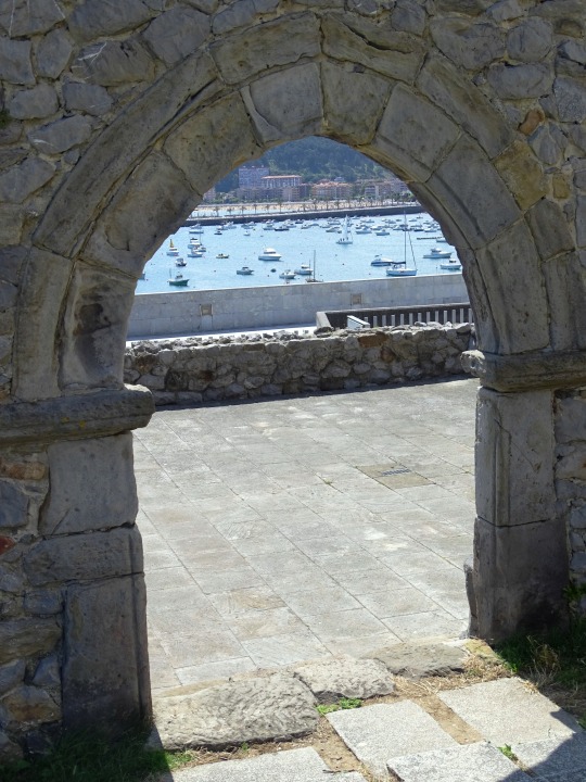

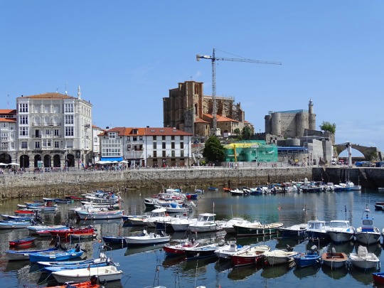
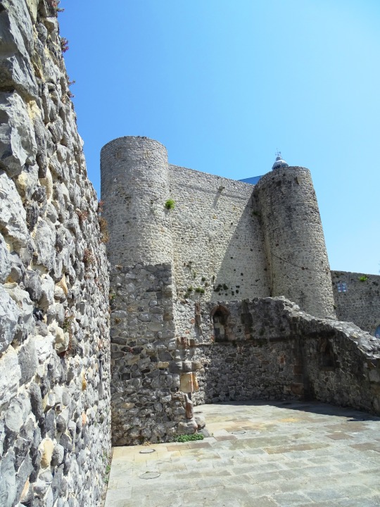
Castle of Santa Ana, Castro Urdiales (No. 1)
The castle of Santa Ana is a fortress located on a rocky promontory in Castro-Urdiales, on a peninsula where there is also the fortified church Sta. Mª de la Asunción (xiii century), the ruins of another previous church (that of San Pedro, from the xii century), and the hermitage of Santa Ana, built as a watchtower, linked to the castle by a bridge. The complex has very good views of the sea, the port and the town. A lighthouse was built inside the enclosure in 1853, whose machinery occupied the chapel. It is one of the best preserved castles in northern Spain.
It has a pentagonal floor plan with cylindrical corner towers 15 meters high, which protect a rectangular enclosure of 22.75 x 12.35 meters; Inside this, in turn, there is a hall of 17 x 7 m covered by a barrel vault. One of the cylinders is actually covering a triangular space that advances from the inner rectangle towards the villa, while the other four act as buttresses of the vault of the living space. Another defense, crenellated and lower, is visible in the part of the lighthouse. It completely lacks gaps, so that the defense could only be done from the towers. The factory is made of cyclopean stones taken with lime. The castle, as well as the citadel, was protected by a wall between 6 and 7 meters high, which preserves a small canvas very deteriorated with the original battlements and merlons.
The access is located on the sea side, through a small door.
It is not known for sure when the castle was founded, speculating that the beginning of the works could coincide with the foundation of the town; However, the founding charter has not reached us. A defensive structure probably existed even earlier.
The current building began its construction in the twelfth century, undergoing various modifications and additions and being abandoned in the sixteenth century.
During a restoration in the twentieth century the lighthouse keeper's house, built inside the enclosure, was demolished. Along with all of Puebla Vieja de Castro-Urdiales, it was declared a historic-artistic site in 1978.
Source: WIkipedia
#Castle of Santa Ana#Castillo de Santa Ana#Faro del castillo de Santa Ana#Santa Ana Castle Lighthouse#Ruinas de Iglesia de San Pedro#España#Ruins of the Church of San Pedro#marina#port#Castro Urdiales#Spain#Bay of Biscay#Cantabric coast#Cantabria#architecture#archaeology#cityscape#tourist attraction#landmark#summer 2021#vacation#Northern Spain#Southern Europe
60 notes
·
View notes
Text

Bay of Biscay / France via NASA Goddard Space Flight Center
#bay of biscay#France#nature#photography#aerial#sea#ocean#bay#water#green#blue#snow#aerial photography#nasa#satellite images
235 notes
·
View notes
Text

Smugglers' Boat in the Bay of Biscay, by Théodore Gudin (1802- 1880)
65 notes
·
View notes
Text

Biarritz. La Villa Belza.
#biarritz#villa belza#1960s#Bay of Biscay#atlantic coast#Pyrénées-Atlantiques department#Nouvelle-Aquitaine region
6 notes
·
View notes
Photo

“Lifeboat drill is regarded by many passengers as an amusing experience but officers of liners realise how important it is that every passenger should learn to be at his appointed station quickly in case of accident. The picture shows one of the youngest passengers on the C.P.R. Liner Montclare wondering what all the fuss is about on the vessel's Bay of Biscay cruise.”
- from the Kingston Whig-Standard. November 18, 1932. Page 6.
#lifeboat drill#lifeboats#bay of biscay#cruise ship#canadian pacific railway#trans-atlantic crossings#passenger ship#shipping news#great depression in canada
1 note
·
View note
Link
From what I gather, this paper's findings are a bit inconclusive. It's hard for me to formulate my thoughts on it.
Following samples taken from trawlers, longline rigs, and electronic catch logs from 1983-2015, the paper examines the distribution of H. griseus in the Bay of Biscay and the Cantabrian Sea.
Findings weren't anything special. Really young H. griseus' were most common and found on continental shelves, whereas the large subadult and/or young adult H. griseus' were found less commonly, and along the continental slopes. The disparity may be due to a larger H. grieus' ability to better escape catchment, especially from trawling.
Sex ratio was 1:1.86~ in favor of females, though 63 of the 146 of the captured specimens were unsexed.
Most of the data is typical for H. Griseus regarding diel movements and water temperature. The difference between the sampling of this population of H. griseus versus the Puget Sound population is that the Cantabrian Sea population inhabits significantly greater depths, day and night.
The most interesting part of this paper was the case study of Shark 2. A 121cm, 9.95kg male who they placed a PSAT tag on. The tag was set to record depth, temperature, and light intensity for a period of 135 days. If there was no change in depth > 0.5m for seven days, the tag would release itself. The tag detached prematurely 84 days after tag and release, producing just 75 days worth of valid data. Shark 2 had died. The data from the tag displayed a 24 hour recovery period of dramatic vertical movements before ultimately settling.
Shark 2's cause of death is uncertain, but could likely have been due internal damage suffered from catch-tag-and-release.
If that was the case, then I shudder at the thought of how the other sharks fared after being caught, considering they were either given a basic plastic tag or none at all. There were some recaptures, though.
#cantabrian sea#bay of biscay#chondrichthyes#elasmobranch#euselachi#hexanchiformes#hexanchus griseus#h. griseus#cow shark#bluntnose sixgill shark#sharks#fish
1 note
·
View note
Text
Tibetan Sand Mandalas
Tibetan Sand Mandalas are intricate and colourful designs made with sand that represent the palace of a Buddha or a bodhisattva. They are usually destroyed after completion to symbolize impermanence.
This life once saw sand art in San Sebastian, Spain. It was sleeping on the street at the time. It had taken to drifting from bench to bench throughout the northern Spanish coastline. Its journey had developed this way after having had its belongings stolen from it whilst asleep on a beach bench in Barcelona. It had drifted and drifted and simply ended up on the Spanish north coast. The sand art at San Sebastian had been intricate and very meticulously designed. It had represented a castle or a dreamscape castle with winding pathways leading up to its fortified palace doors. Once the watchers and photo takers had paid their respects to the slowly carved sand art the waters of the Bay of Biscay would seep up and over the built sand structures. Before much time had passed they were reduced to their natural grain state. The artists of the sand art would return the following morning and begin their craft of redesigning their sand art. This life does not know, because it never did ask, if the impermanence of the art pieces represented or were in homage to Tibetan Sand Mandalas. It is very possible they were because without our knowing we continue upon our life journey in representation of the impermanence of what this present living is.
1 note
·
View note
Text
The Bay of Biscay

View On WordPress
0 notes
Text

It's November 7th. 🏰 On this day in 1659, King Louis XIV of France and King Philip IV of Spain signed the Treaty of the Pyrenees. This marked the end of the war that had been going on between the two nations since 1635. It also marked the beginning of one of the world's strangest geopolitical arrangements, and it's still in effect today.
Negotiations were had been conducted and signed on Pheasant Island, which sits right in the middle of the Bidasoa river on the border between the two countries. One of the conditions of the treaty was that the island would be forever treated as a condominium. In international law, a condominium is defined as a territory over which multiple states hold joint sovereignty. Because the success an arrangement like this requires strict cooperation between all parties, for a condominium like Pheasant Island to last this long is very unusual. Other condominiums currently in existence around the world include Antarctica, Caribbean Joint Regime Area, Gulf of Fonseca, Lake Constance, Abyei, Brčko, and Moselle.
The treaty of the Pyrenees defined the boundary between France and Spain that runs along the Bidasoa River from the Pyrenees Mountains to the Bay of Biscay in the Atlantic Ocean. A huge monolith embossed with these conditions stands on the island. Delegates from both France and Spain meet here every February 1st and August 1st to exchange documents and transfer sovereignty to other nation. ☮️ Peace… Jamiese of Pixoplanet
#Jamiese#Pixoplanet#Isla De Los Faisanes#Pheasant Island#Hendaye#Mendelu#Irun#Biriatou#Bidasoa#Pyrenees#Bay Of Biscay#Spain#France#Treaty Of The Pyrenees#Treaty#King Louis#King Philip#Geopolitics#Bidasoa River#Pyrenees Mountains#Condominium#International Law#Caribbean#Gulf Of Fonseca#Fonseca#Lake Constance#Abye#Brčko#Moselle#Biscay
0 notes
Photo
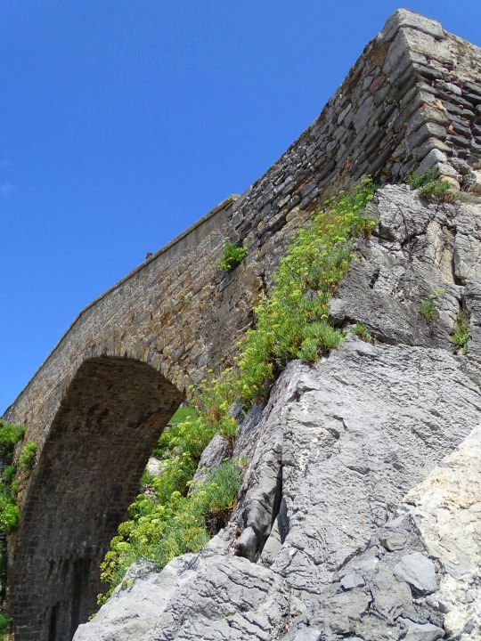


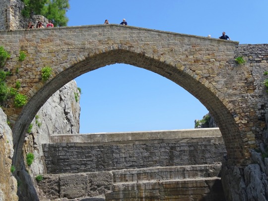

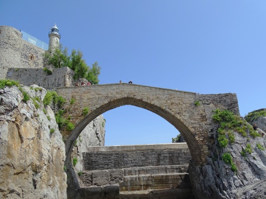

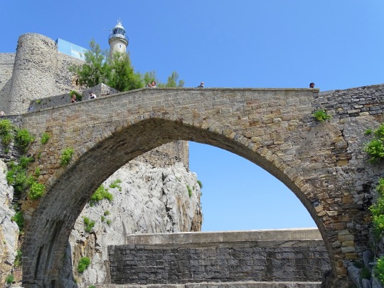


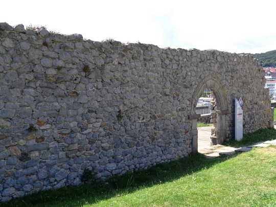
Medieval Bridge, Castro Urdiales
The often misnamed "Roman bridge" by the whole world, is also located in the port, in front of the Rock of Santa Ana.
However, the construction of this bridge is located in the Middle Ages, although due to a storm the upper part had to be rebuilt some years ago.
It is built in stone in the shape of an ogival arch and was part of a set of bridges and footbridge that joined the promontory where the castle-lighthouse is located with the hermitage of Santa Ana isolated from the earth since the rock was surrounded by the sea until the construction of the current port.
The bridge and the footbridge sisters of this, were demolished in the early twentieth century to facilitate the installation of the machinery responsible for building the breakwater.
At the foot of the bridge, the presence of a sea inlet confined in a large construction as a quadrangular stone pool that fills and empties according to the level of the tide is surprising.
Source
#Roman bridge#medieval bridge#puente medieval#Castillo de Santa Ana#Santa Ana Castle Lighthouse#Castle of Santa Ana#Faro del castillo de Santa Ana#architecture#cityscape#travel#vacation#Church of Santa María de la Asunción#Santa María de la Asuncion Church#Iglesia de Santa María#original photography#Castro Urdiales#Cantabria#Atlantic Ocean#Bay of Biscay#summer 2021#tourist attraction#landmark#hermitage of Santa Ana#Southern Europe#España#Northern Spain#Spain
7 notes
·
View notes
Text
Basque Coast Geopark, Spain

Today we're on the Basque Coast of northern Spain, home to one of the most unique and remarkable geological formations on the planet. The Bay of Biscay, featured in today’s image, is a gulf along the west coast of France and northern Spain. The part of the Bay of Biscay on the northern coast of Spain is known locally as the Cantabrian Sea, and has a long history of creating challenging weather conditions for sailors. While the average depth of the gulf is estimated to be around 1,745 metres, the continental shelf extends to the bay causing shallow waters which can pose a problem in stormy weather.
The Basque Coast Geopark is situated in the southernmost region of the Bay of Bascay. With 89 square kilometres of hilly countryside and a 23-kilometre-long coast characterised by limestone mountains and flysch cliffs, visitors can discover 60 million years of uninterrupted geological history here. It’s a wonderland for geologists, and for people who just like looking at interesting rocks. There are two guided tour options - for visitors wishing to explore the coast, and to potentially see whales and dolphins, the Flysch Route is a fantastic option, whereas the Karst Route takes visitors inland to explore both the natural and cultural heritage of this ecologically diverse coastal region.
1 note
·
View note
Text
Supposed to be doing homework but instead cross connecting multiple traditional folk songs in awe of the tapestry of human storytelling
#you can go from 'what put the blood' to 'edward' to 'the twa brothers' to 'sweet william's ghost' to 'willie the waterboy' to#'the bay of biscay'#bern speaks#folk song
2 notes
·
View notes
Photo

The path to San Juan de Gaztelugatxe, Basque Country / Spain
0 notes
Link
In this study, the authors examined logbooks from trawl surveys, commercial vessels, and tagging surveys dating from 1983 to 2011 in the Bay of Biscay (northern Spain and western France) for catch records of Hexanchus griseus. This bay is defined by an extensive continental shelf along western France, and a much steeper, narrower shelf around Spain.

In this image, we can see locations of the catches. Red dots are from trawl surveys and the yellow rhombus’ are from electronic logbooks of longline vessels.
The purpose of this study was to examine all existing data of H. griseus in this area to better understand the shark’s ecology, distribution, seasonality, and swimming behavior.
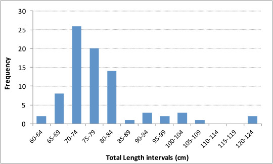
According to the e-logs, most of the sharks caught were from NW Spain during autumn and winter months. Catch depth ranged from 100m to 1750m and weight of captured specimens was estimated to be between 50kg to 600kg. This weight data can be turned into a TL estimate through a developed formula (W = a*TL^b), and the range was 2 meters to 4.5 meters total length.

When examining the trawling surveys, however, most of the individuals were 60cm to 121cm TL; neonates and juveniles. This fascinating dichotomy has a couple explanations. It could mean that H. griseus is spatially segregated by age, with younger sharks occupying shallower waters and older sharks occupying deeper waters. Another explanation could be that larger sharks are better able to escape a trawl net than smaller sharks. This bias could not be ruled out. Larger sharks are faster and better able to evade threats than their smaller relatives.
Most of the large sharks were caught by longline and gillnet vessels, with the gear hovering about 2.5m-10m above the sea floor. All this bearing in mind, it aligns with many other similar studies of H. griseus. This shark occupies and epibenthic space where smaller specimens stay in shallower waters and larger sharks occupy deeper waters. No sex relationship could be discerned, as much of that data was not recorded. But based on other studies, we also know that H. griseus tends to segregate by sex, as well, post-maturation.

Above is a map showing the locations of two tagged sharks caught via longline tagging survey. Shark 1 was equipped with a rototag and was recovered 3 years after tagging by a gillnet vessel 9nm away, outside the Marine Protected Area (MPA). The shark was released after catch, but no morphometric data was recorded beforehand, sadly.
Shark 2′s story is far more interesting, and will take up the bulk of this discussion. Shark 2 was equipped with an MPAT tag--a satellite tag that records depth and temperature over time before releasing itself and floating to the surface for recovery and dissemination--and the data recorded gives us a lot to work with. The tag itself was released prematurely after just 84 days. This was due to a contingency designed in the event that depth measurements do not significantly change after a nine day period. Thus, 75 days of valid data were recorded.
The tag released only 4nm (nautical miles) from the equipment location. the last 7 days of the tags data showed a constant depth, suggesting that the shark died and was resting on the sea floor. Some oscillating depth variation was displayed, but that was due to the tides. You may be wondering what killed Shark 2, and the answer is unclear. The authors speculate that physiological trauma from the catch was responsible; citing gas bubble formations in the tissues. This is not an unreasonable inference. Hexanchus griseus has, historically, displayed a recovery period after catch lasting up to 72 hours, wherein erratic behavior is suggested by depth over time recordings.
It is possible that Shark 2 suffered for much longer, however. We do see this erratic behavior in the graph, below, but other natural causes are also possible. Parasites, disease, and predation could also be to blame, other than fatigue.

Figure A shows the recovery period, and Figure B shows the moment of death. Examining the whole, though, we can see that Shark 2 returned to a depth of 900m-1000m after stabilizing. The oscillations could be from the shark getting pushed around by tidal currents, or it could be an active swimming pattern or foraging up and down the slopes.
This data provides an interesting contrast to studies performed on H. griseus around Hawaii and Virginia, where the sharks occupied shallower waters (200m-450m) and displayed more movement. That’s more than double the daily depth variation on display with Shark 2 (note: for the uninitiated, H. griseus occupies shallower waters at night, then makes a vertical migration at dawn to deeper waters for the day, and at dusk returns to shallow waters). Those waters are poorer, however, which would necessitate greater foraging effort. The Cantabrian Sea is a biologically rich area of the ocean, so H. griseus’ ranging in the Bay of Biscay likely do not require such activity for sustenance.
Despite all this, this is a case study of a presumed dead shark. We cannot assert any pattern of behavior from it.
While H. griseus is found most commonly along continental slopes, they have been seen around islands and sea mounts, such as the juvenile spotted SE of Rapa Nui a few years ago, suggesting that this species is capable of long-range migration. Younger individuals, however, tend to remain in a relatively small area, as is the case in Puget Sound, a highly productive estuary and nursery for this species. Young H. griseus spends around four years developing in the Sound before leaving for the open ocean. It is likely that the sharks living in the Cantabrian sea do not migrate very far, as inferred by Sharks 1 and 2 being tagged and recovered in and around the MPA.
An interesting anomaly I learned while reading is that H. griseus can survive in temperatures as high at 20 degrees Celsius, but appear to prefer 8-13 degrees.
One of the things I drew from this study is how our actions affect the life we study. By dragging Shark 2 up from 1km beneath the surface to tag it, the researchers may very well have been responsible for its death. With the current state of ROV technology, perhaps we can avoid these fatalities and disruptions by tagging and observing Hexanchus griseus remotely, without hoisting them from the sea. We must account for the effect of our physical interactions with the subject and its effects on the data and observations we record.
No doubt the researchers didn’t know the shark would die. It’s possible that the shark was already in poor health and susceptible to extreme consequences of catch-and-release methods. After all, other Hexanchus griseus subjects have underwent the same treatment and lived. But this isn’t about numbers--if I may take an emotional stance for a moment--it’s about expanding our knowledge without destroying those which we seek to understand; and I think we’re finally able to achieve that.
Until next time.
#eukarya#animalia#chordates#chondrichthyes#elasmobranchs#selachimorpha#hexanchiformes#hexanchidae#hexanchus griseus#h. griseus#cowshark#cow shark#bluntnose sixgill shark#shark#fish#marine biology#france#spain#cantabrian sea#bay of biscay#2017#cristina rodriguez-cabello#cesar gonzalez-pola#augusto rodriguez#francisco sanchez
1 note
·
View note
Last Seen Blogs

prionsa
little defect

lion-time
vld x vf x dotu

swagginmun
Swaggin'Mun


benrey-keeps-forgetting
Father Grigori with internet access