#camp bushwhack
Text

New History Podcast episode has dropped! This is part 1 of the 4 part series over the inspiring and mysterious young writer, poet, amateur archaeologist, painter, traveler, wanderer, and adventuring vagabond for beauty that is Everett Ruess. Everett Ruess explored extensively California and the American Southwest with his outstretched thumb, on the back of pack animals, and on his own feet. He’d camp, hike, bushwhack, meet famous artists and archaeologists, Navajos, Hopis, Mormons, bootleggers, and many a cowboy. He’d paint and write about the infinite beauty of the California Coast, the Sierra Nevadas, and The American Southwest. But at 20 years old, Everett Ruess would disappear off the face of the Earth in Southern Utah, in Grand Staircase-Escalante National Monument. Listen on major platforms and link to episode is in the bio!
11 notes
·
View notes
Text
a discord prompt from @nirnwrote - "Mountain Stream, Late Morning, Cold Hands" from this list
“What do you think Brother Martin is going to say,” Coradri says with a sly tilt to her voice, “when we tell him we were late because you had to collect potatoes.”
It’s the first time either of them have spoken since they set out at dawn. Breaking camp this morning was miserable, freezing work— climbing out of the warmth of the tent seemed an impossible hurdle. But after a few hours of walking, the grouchiness tends to fade. They’re out bushwhacking, boots crunching through frost-rimed underbrush as they cut through the mountains. The cold clear creek beside them will lead them all the way to the silent sentinel mountains where Cloud Ruler Temple waits.
“Jumbo potatoes,” Tanis corrects. “He’ll give me grief for letting him worry and then he’ll eat the bread and his words. Don’t you tell him I said this, but that S’jirra might even be a better baker than he is.”
Not so long ago the woman sent them off with two carefully-wrapped loaves. The night before she’d let them sleep in hammocks in her cozy house, rich with the mushroomy smell of rising dough, and filled their bellies with a spicy, creamy corn-and-potato stew that he sorely misses now. A stark contrast to this morning: waking with a stiff back and gnawing a hunk of dried venison as they walked, to save time.
“You sellswords are so treacherous,” Coradri says, mock-scandalized, a hand laid primly over her heart. Her fingertips are pale and bare in the cold. He ought to get the little ragamuffin some proper mittens; she never buys anything practical with the money she sneaks out of his purse. North of Chorrol, the month of Frostfall lives up to its name.
Tanis thinks of frostbite; he thinks of growling stomachs and sore feet; he thinks of fat crispy trout atop soft slices of potato bread. “S’about midday, or close enough. What do you say we make a fire, and catch us a couple fish in the brook, and take a rest?”
“We’ll be even later.”
“The priest will forgive us,” Tanis says, grinning at her, “if we manage not to eat all the bread before we get back.”
26 notes
·
View notes
Note
On my first reread and was intrigued by Blackfish asking Lysa for leave to take a thousand seasoned men and ride for Riverrun, naturally she declined. However I wonder what kind of impact this fighting force would've had. Ofc politically it would bring the Vale into the fold but assuming it was only these extra 1000 men under Blackfish's command, what tangible impact would they have had in the field during the WotFK? Tywin less aggressive? Maybe whispering wood never happens. Roose stays loyal?
It's a good question.
The Blackfish is a capable outrider and bushwhacker, and could use them to harry the invading Westerlander army. Since Brynden Tully meets up with Robb at Moat Cailin, it's likely that he remains with Robb and continues on apace. I'm not sure much changes, though, unless another commander can take those men and overrun Forley Prester's camp in the east of Riverrun. If that happens, and the Westerlander army is completely scattered, news is slower to reach the Lannisters of the complete defeat, which might mean that the Northmen-Westerlander army can pin Tywin in the east - although that's a big if. Tywin learned from a messenger, if one can escape, then Tywin withdraws the way he did in OTL.
Thanks for the question, Hero.
SomethingLikeALawyer, Hand of the King
12 notes
·
View notes
Photo

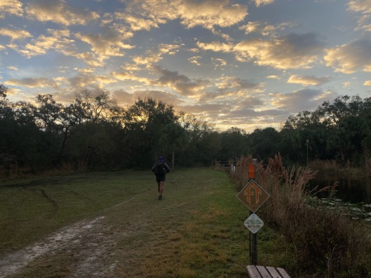
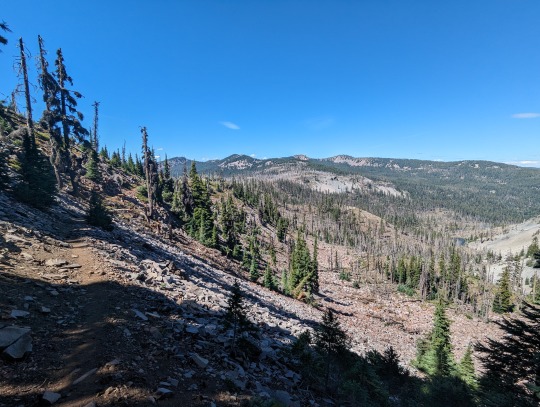
Hayduke Day 52: Our plan for Zion National Park (i.e., the end of the trail) is to hike up the west end of the park, camp outside the park tonight along the western border, and then enter the park from the northwest via the West Rim Trail - this will then take us down into the valley and to the finish. Today begins in a wash, but we quickly find a nicely groomed National Park trail that we follow for a few miles before heading cross-country once again. Navigation is a bit tricky, and it doesn’t appear our route has been well-traveled. That said, we make steady progress and eventually reach the one off-trail pass we need to conquer today before making it out to the road to the west. It goes without much fuss, and the descent ends up being trickier than the climb. Boulder jams and dry falls block the route at several places, and a few require annoying bushwhack to bypass. The bottom of the canyon we exit is choked with brush, and our progress slows even more (in addition to our feet now being wet). We make it to Right Fork and head west to Great West Canyon (mostly walking in the river) as the bushwhacking lets up a bit. Impatience at the final climb up to the road causes us to cut straight up from the canyon via a crumbly slope followed by yet another bushwhack. Should have just found the trail at the bottom (we find it part of the way up, and travel becomes much easier). At the trailhead, we find the road we suspected would be dirt is actually paved - and with no shoulder to walk on. @oldmanrigney and @kasekittykoopkat have made it back to their car at Hack Canyon, and they come to retrieve us. They pick us up and drive us a few miles up the road to Lambs Knoll - a BLM campground outside the park where we’ll stay tonight. They also bless us with a feast fit for a finish, including nachos, multiple pizzas, beverages, a cake, and more. With full bellies and a privy across the parking lot, we all cowboy camp under the campsite’s shade structure. Day: Rockville to Lambs Knoll Distance: 14.16 mi / 22.79 km Elevation gain: 3,474 ft / 1,059 m #hayduketrail #EXTREMEWALKING
2 notes
·
View notes
Text
Books of 2023:
Book 13 of 2023
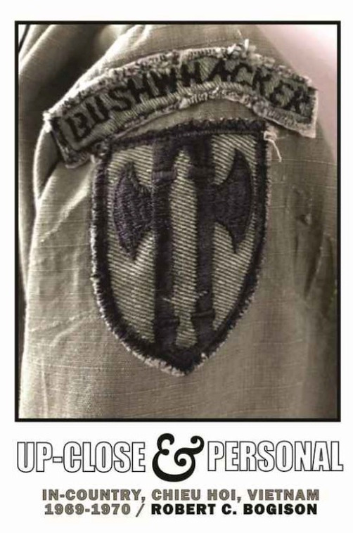
Title: Up-Close & Personal: In-Country, Chieu Hoi, Vietnam 1969-1970
Authors: Robert C Bogison
ISBN: 9781097969142
Tags: AC-47 Spooky, EOD, FSB Dirk (Vietnam War), FSB Schroeder (Vietnam War), III Corps (Vietnam), KHM Cambodia, KHM Cambodian Incursion (1970) (Vietnam War), Military Police, THA RTA Royal Thai Army, UH-1 Huey, US CIA Central Intelligence Agency, US USA 159th Transportation Bn, US USA 159th Transportation Bn - 5th Transportation Co. (Heavy Boat), US USA 18th Military Police Brigade, US USA 1st ID, US USA 212th Military Police Sentry Dog Co, US USA 25th ID, US USA 284th Military Police Co., US USA 39th Infantry Regiment, US USA 39th Infantry Regiment - 2/39, US USA 458th Transportation Corps, US USA 504th Military Police Bn., US USA 504th Military Police Bn. - 188th Military Police Co., US USA 557th Military Police Co., US USA 615th Military Police Co., US USA 716th Military Police Bn., US USA 720th Military Police Bn., US USA 720th Military Police Bn. - B Co. (Bushwhackers), US USA 89th Military Police Group, US USA 90th Replacement Bn, US USA Army Tugboats, US USA Colonel Robert A. Rheault, US USA Combat Trackers - K9, US USA Fort Gordon GA, US USA Fort Leavenworth KS - USDB CTF Correctional Training Facility, US USA Fort Leavenworth KS - USDB United States Disciplinary Barracks, US USA Fort Riley KS, US USA Fort Riley KS - CTF Correctional Traning Facility, US USA PBR Patrol Boat River, US USA Sgt. Alvin Smith, US USA ST 2122 El Cid - Small Harbor Tugboat, US USA United States Army, US USMC United States Marine Corps, USA 5th SFG, USA 9th ID, USA Green Berets, USA Special Forces, VNM 1st ID, VNM An Hoa Hung Village, VNM Bearcat Base / Long Thanh North Airfield (Vietnam War), VNM Bien Hoa, VNM Bien Hoa Airbase (Vietnam War), VNM Camp David Long (Vietnam War), VNM CIA Phung Hoang / Phoenix Program (1965-1972) (Vietnam War), VNM Cu Chi, VNM Cu Lao Ba Xe Leper Colony, VNM Da Nang, VNM Dong Nai Province, VNM Dong Nai Province - Buffalo Shack, VNM Dong Nai Province - Cogido Bridge, VNM Dong Nai Province - Duck Farm, VNM Dong Nai Province - Finger of the Land, VNM Dong Nai Province - French Fort, VNM Dong Nai Province - French Pier, VNM Dong Nai Province - Heel of the Booth, VNM Dong Nai Province - Rabbit Ears, VNM Dong Nai Province - Rice Mill, VNM Dong Nai River, VNM DRV NVA Thai Khac Chuyen / Chu Van Thai Khac, VNM Green Beret Affair (Vietnam War), VNM Highway 1, VNM Hill 15, VNM Hill 85, VNM Lai Khe, VNM LBJ Long Binh Jail - USARVIS US Army Vietnam Installation Stockade (Vietnam War), VNM Long Binh, VNM Long Binh Post (Vietnam War), VNM Michelin Rubber Plantation, VNM Operation Corral (1967) (Vietnam War), VNM Operation Stabilize (1967-1970) (Vietnam War), VNM RVN ARVN Army of the Republic of Vietnam, VNM RVN ARVN MP Quan Canh Military Police, VNM RVN ARVN RF/PF Regional Forces/Popular Forces (Vietnam War), VNM RVN RVNP Can Sat National Police, VNM Song Buong - Black River, VNM Tan Hiep, VNM Tan Mai, VNM US Project Gamma - Det B-57 - E Co (Vietnam War), VNM US USA 24th Evacuation Hospital - Long Binh (Vietnam War), VNM US USA 93rd Evacuation Hospital - Long Binh (Vietnam War), VNM USA MRF Mobile Riverine Force (Vietnam War), VNM Vung Tao
Rating: ★★★★★
Subject: Books.Military.20th-21st Century.Asia.Vietnam War.US Army.Military Police
Description: The Vietnam War has tormented American consciousness for more than half a hundred years, and shows no sign of flagging. Up-Close & Personal is a signal contribution to understanding that drawn-out conflict from a soldier's point of view, informed by knowledge gained from being "up-close" at the basic, ground-pounding or river-patrolling combat level. The author pulls no punches. Detail is uncompromising, hard, often excruciating. All this amid the tumult of politicized youth on the home front shouting "Make love not War" and "Tune in drop out.
Review: I tend not to give 5 stars to books, as I like to reserve that for books that have a profound effect on me.
This book qualifies and let me explain why.
It's not a perfect book by any means. There are little errors here and there with spelling and such, plus the story isn't that captivating/page turning thrilling. It can even be a slog at times.
So why 5 stars? Because Bogison does what few others can - he really conveys the emotional aspect of his thoughts, his feelings, his mental state, his wrestling with what to do, how to do it, what is right and what is wrong... in big decisions and small. He doesn't just tell the good, but also the bad, he explains the stuff he wrestles with and not everything gets wrapped up nice and clean and with a little bow.
When I grabbed this book, I was expecting a story about a Military Police in Vietnam. I was expecting a lot of bar fights, investigations of murder and accidents, regular law enforcement stuff. By the title, I also expected discussion of the Chieu Hoi Program/Force 66 - Luc Luong 66. - Let me be clear, this book has 0 of that... none.. nada... zip zilch... NO.
Instead it's a book about an MP who is assigned to correctional facilities in the US (Ft. Riley) and Vietnam (LBJ) and ends up in a very special unit of MP's that is called an Ambush and Recon unit made up of MP's instead of infantryman! Because of the location in the Delta, they also have a joint unit with PBR's and skimmers that he finds himself leading as well.
It was fascinating to read, the people, the stories, the bureaucracy, and more was captivating and it left me really thinking about the choices he made and how his personality affected his life's course. His temperament is always to attack, to challenge, to push - even against those who are trying to help him. He either sits quietly or attacks ferociously even when confronted with cooler heads to learn from and imitate - he does neither.
Whether it was the helicopter crash, the tug boat incident, or a handful of other stories included, one can't help but really feel what the author felt as he just did his best, and all too often memoirs like this one are more about snippets of stories, or tell you what happened but forget the human element. This one has a consistent narrative and does well to really put you in his boots, and look through his eyes.
3 notes
·
View notes
Text
me every day: yeah well i don't really like ludo as much as i used to and a lot of their songs miss that sweet spot between being genuinely creepy and making fun of creeps, and one of them has extremely weird undertones about south america that i'm not a huge fan of? ultimately they're great storytellers which is why their later albums focus more on that than they do just straight up heterosexual romance from an ostracised nerdy guy perspective, which is a shift in focus i appreciate a lot. they were a great band for me to like during my weird-angsty preteen years and they still feel like a home to me but i like better music now
me the second hum along comes on: maybe you'd be kidnapped by pirates and they would take you to their hideout, as pirates often do, but i'd find the secret map and i would vigilante bushwhack through the jungles of peru just to save you and i'd take you north to mexico where you would tell me your life story on the steps of a mayan temple where we'd camp singing nonsense songs in twelve bars to the jaguars until you'd sense me, your eyes convincing, AND I WOULD KISS YOU LIKE A HERO IN THE HALF LIGHT!!! DRYER!! SHEETS!! AND!! PEACH!! SHAMPOO!!! THE SMELL OF PALM LEAVES I'D SLEEP AGAINST YOU [skip this part bc it's really iffy] AND WE COULD STAY THERE SPEND OUR DAYS THERE EATING GUAVA BY THE SEA!! AND I COULD UNDERSTAND YOUR VIEWS AND YOU COULD FALL IN LOVE WITH ME!!!!
#see the thing about this song is i can't tell if it's making fun of guys like this or if it's genuine#they put a lot of emotion vocally into songs that are definitely satire (good will hunting by myself)#but also they DO have a lot of songs about sweeping unbearable devotion (broken bride album and all the stars in texas)#but at the same time it's just so heartfelt#BUT EQUALLY the bit i skip singing plays into racist ideas which makes it seem like they're mocking the speaker more?#idk it also makes me uncomfortable. this song would be perfect without that line but that line is there and it's bad
3 notes
·
View notes
Text
Colter: Old Friends
youtube
Full Transcript below ([...] placed where a gap of silence is for the same person speaking.)
[Arthur enters the small cabin where Bill, Lenny, Micah, and Javier (Who is outside) are staying.]
Micah Bell: …up with you boys, because I thought you liked action. Couple of days on the lam… and you lot have all turned yella. (to Lenny) Apart from you, of course.
Lenny: Shut up, Micah.
Micah: I ain’t never seen so many long faces.
Bill: I guess… I guess folks miss them… that fell.
Micah: Well, when I fall, I don’t want no fuss.
Lenny: When you fall… there’ll be a party.
[Everyone laughs]
Bill: A party… probably.
[Micah stands and takes a step towards Bill]
Micah: That funny, huh?
Bill: Sure.
[Micah hits him in the face and walks towards the exit. The others grab Bill to keep him from fighting back.]
Micah: Maybe I don’t feel like being laughed at by the likes of you two.
[Dutch enters.]
Dutch: Stop it! Now! You fools punching each other… when Colm O’Driscoll’s needing punching, hard. You wanna sit around waiting for him to come find us? All of you, we got work to do. Come on.
Arthur: (with cigarette in his mouth) Are you sure about this, Dutch?
Dutch: Yes.
Arthur: Folks been through a lot recently… we hardly back on our feet yet.
Dutch: And the last thing we need is to get bushwhacked by Colm O’Driscoll. Let’s go.
Arthur: I know you hate him, Dutch.
Dutch: He’s here for us.
Arthur: I doubt that.
Dutch: No, you’re just doubting me.
Arthur Morgan: I would never doubt you, Dutch, you… you always said revenge is a luxury we can’t afford.
Dutch: This is the right call, Arthur. Take this.
[He gives Arthur a rifle.]
Dutch: And this is about more than revenge for business long ago. They were talking about trains and detonators. Here. Colm always had good information. Come on.
Arthur: And you think now is the right time to hit a train?
Dutch: Now you might fancy living on deer piss and rabbit shit… I’m getting too old for that life. Mr. Matthews, Mr. Smith, Mr. Pearson… would you please look after the place… there are O’Driscolls about. H’yah!
[Dutch, Arthur, Micah, Bill, Lenny, and Javier leave the camp on horseback.]
Dutch: Southwest, right, Arthur?
Arthur: Yeah, he said follow the main trail southwest. They’re camped near some lake.
Dutch: Okay, let’s go find these bastards before they find us, and rob this score they’re planning.
Dutch: What’s that? Tracks… horses, quite a few of ‘em. Far as I can tell, the only fools out here are us and them… they must be this way.
Arthur: You good, Dutch?
Dutch: Of course. Listen, I know you don’t think much of my ideas recently, but this is the right move.
Arthur: Okay… you know I got your back.
Dutch: I learned a long time ago that you hit Colm O’Driscoll, wait for him and people you love will die.
Arthur: *sighs* This feud between you and him… needs to be put to rest, one way or another.
Bill: It will be.
Dutch : Some things I can forgive, others I can forget. What he did to Annabelle, I can’t do neither.
Arthur: You killed his brother, Dutch.
Dutch: (harshly) Yes, I did. And I hope the bastards’ll be reunited soon enough. That’s how this’ll end.
Micah: Damn right, boss.
Dutch: See that smoke? Let’s cut up here and take a look. They said it was near the lake, so we must be close.Hold up here. Alright, gentlemen, this is it. Are we goddamn ready?
Javier: Ready, Dutch.
Lenny: Ready.
Dutch: Good. Now, Mr. Morgan and I, we’re going to head up here a little, see if we can’t get a sense of the layout of the camp. Mr. Williamson, Mr. Bell, you two take up a hidden position just outside the camp. Mr. Summers, Mr. Escuella, you two hold position here. Let’s go.
[Arthur follows Dutch on foot. Having climbed higher, they look at the camp through binoculars.]
Dutch: There they are… That’s definitely them.
Arthur: Colm?
Dutch: I think…
Arthur: Yeah… that’s him.
[They watch as Colm waves Kieran over before mounting his horse. Kieran speaks to him, using arm gestures.]
Dutch: Who’s he talking to? He don’t seem very happy.
Arthur: No…
[They watch as Colm slaps Kieran before Kieran goes to his own horse, mounts, and leaves]
Dutch: Are they leaving?
Arthur: Seem to be. Should we go get ‘em?
Dutch: No. Colm can wait. Best to get some of them outta there. And much less fun to rob him and his score if he never finds out about it.
[They two stand and head back to where Lenny and Javier wait with the horses.]
Dutch: Alright, let’s go pay our old friends a visit. Don’t forget to grab that rifle from your horse. You boys be ready to pick them off from up there.
Lenny: Sure thing.
Dutch: Good. Come on, let’s go. Seems easiest to take the same path down as Bill and Micah. Like you said, revenge is a luxury we can’t afford.
Arthur: Yeah, I just wasn’t sure you agreed with me.
Dutch: Arthur, Arthur, have you completely lost faith in me? Our needs right now are supplies, equipment and a way out of here. Everything else, including Colm, can wait.
Arthur: Okay.
Dutch: There’s enough of those bastards down there to deal with as it is. Now come on. It’s steep here, careful.
Arthur: Maybe I should take the lead on this. They’re going to be gunning for you.
Dutch: They ain’t got me yet.
Arthur: No, but the way our luck’s been running…
Dutch: Hush, let’s just get down there first. Down through these trees, quick. Stay low. Come on, follow me. Get in cover, Arthur.
[They sneak into O’Driscolls’ camp.]
Arthur Morgan: (whispering) So what are we doing, Dutch? I can take this if you want.
Dutch: Just make the call. You wanna take the lead? Go.
=Take the Lead=
Arthur: Okay, I’ll go first. (shouting) O’Driscolls! You’re dead, you sons of bitches! I’m moving up, put some fire behind me!
Dutch: With Arthur, let’s go! There’s one up on the water tower!
=Send the gang=
Arthur: Okay, fine, you make the move.
Dutch: Alright, on me. Good luck.
[Dutch fires first]
Dutch: Kill every last one of these bastards! [...] Keep pushing forward
|
Dutch: Look out! We got more in those cabins to the right. [...] Oh, dammit! They’re still hiding in those cabins.
Bill: I think that’s all of them!
Dutch: Search the bodies, strip everything we can from them!
Bill: You recognize any of them, Dutch?
Dutch: Of course not. Colm doesn’t give a damn about his men. All he cares about is numbers. If you can shoot a gun, and ride a horse, and kill without thought, you’re in. Think how long some of you have been with me? I imagine Colm doesn’t even know half the names of these fools.
=Take too long to loot bodies=
Dutch: Keep looking! We need everything we can get off of these bastards! [...] Keep searching the bodies, Arthur!
|
[After looting two bodies gunshots are heard]
Dutch: Heads up, boys! We got more of the bastards coming in from the forest! [...] Shit, there’s a lot of ‘em. What do you think, Arthur? Should we hold ground here, or go at them?
=Advance=
Arthur: I say we go at the bastards!
Dutch: Come on then. Everyone with me! [...] There must be more of them in the forest. Let’s go.
[After the fight]
Dutch: The cowards are running away. Good work, boys.
=Defend=
Arthur: Reckon we’re better holding here.
Dutch: Alright, pick ‘em off as they come outta the trees!
Bill: Don’t lose them in the trees!
[After the fight]
Dutch:The cowards are running away. Good work, boys.
|
Dutch: Back to the camp. We’ll get what we need and clear out.
=Get there before Javier and Lenny=
(Take a bit too long and Dutch says: We don’t have time to mess around.)
Dutch: Okay, let’s wait for Javier and Lenny… they’re coming down with the horses.
[The two lead the others horses down to the group.]
Bill: Keep an eye out for any more of the bastards.
[Dutch whistles for his horse]
=Take too long=
Dutch: Arthur, get over here. [...] We don’t have time to mess around. [...] We’re waiting on you, Arthur.
[Once Arthur finally joins the others, Dutch whistles for his horse.]
|
Dutch: Good work, boys. Now, let’s tear this place apart. [He mounts his horse] Bill, you go search that wagon there. Arthur, you take that building to the left. Alright men, quick! Find those detonators, explosives, anything you can. Let’s go.
=Micah=
[Micah finds a rolled up map and opens it on the table inside the cabin he was searching.]
Micah: What have we got here? [He unrolls the map.] Perfect… their plans…
=Bill=
[Bill says no dialogue and finds nothing in the cabin he’s searching.]
|
[Arthur opens up a crate labeled “Samson Bros - Saint Denis - Dynamite”]
Arthur: Here… this looks good… [He turns to Bill who enters] what you think Bill?
Bill: Looks fine… smells good.
[Arthur hands a crate to Bill who puts the dynamite he was holding on top.]
Arthur: Come on.
[The two leave the building to rejoin the others.
Dutch: Did we get everything?
Micah: Think so, Boss. Found this on one of them.
[Micah hands the map up to Dutch who unrolls it.]
Dutch: Thank you.
Bill: (about the dynamite) This is perfect.
Dutch: Oh yeah, interesting… this is something about the train they was gonna rob. A Mr. Leviticus Cornwall. Mount back up, let’s keep moving.
[They mount up and headout.]
Dutch: Alright, let’s get outta here. Proud of you boys! All of you. Not a man down.
Bill: Good work, fellers.
Dutch: Not bad for some starving down-and-outs. They can pummel us as hard as they like, but we will always get back up and fight. That’s who we are. Outlaws for life, fellers. Wait until we have John, Mac, Charles and Sean back riding with us, and I believe I know… they will all be back.
Arthur: You didn’t get Colm, but this hit will hurt him a lot more than any bullet in the head.
Dutch: Especially when we rob this train, too.
Arthur: *laughs* Yeah, I guess we’ll see about that.
Dutch: Oh, indeed we will.
Arthur: You know… he’ll come after us.
Dutch: Oh, of course he will, just like all the rest. But we’re going stay a step ahead of them, make sure we always know where they are before they know where we are. We allowed ourselves to get a step behind in Blackwater. That won’t happen again. Alright, dig in, fellers. Let’s make some ground.
[They ride for a bit until they see a man and a horse in the distance.
Dutch: Hey, you see that feller? Wasn’t he at the camp with Colm?
[In the distance you can hear the man making panicked noises as he quickly mounts his horse upon spotting the group.]
Arthur: Leave him to me.
Dutch: Alright, we’re heading back. Just bring him back alive. He could be useful.
Arthur: Okay, you got it.
[Arthur chases after the man.]
[Arthur catches up with Colm’s hired gun galloping on a horse. He prepares his lasso.]
O’Driscoll: You got the wrong feller!
[Arthur lassos the man.]
Arthur: (unsubtitled - upon lassoing) Not so fast there.
O’Driscoll: Shit, no!
[Arthur hogties him]
Arthur: You’re coming with me.
O’Driscoll: Please, please, you don’t need to do this.
Arthur: (unsubtitled - looting) Just isn’t your day is it?
O’Driscoll: You got me mixed up with someone else.
Arthur picks him up and stows him on his horse.
O’Driscoll: Come on. I-I’m nobody, mister.
[Arthur mounts up and heads back to camp.]
Arthur: What’s your name, boy?
O’Driscoll: I don’t know!
Arthur: You don’t know your name?
O’Driscoll: It’s Kieran.
Arthur: Kieran what?
O’Driscoll: Duffy. Kieran Duffy.
Arthur: Well, I ain’t gonna lie to you… this is a real bad day for you, Kieran Duffy.
Kieran: Where are you taking me?
Arthur: Somewhere you ain’t gonna like.
Kieran: Why? What are you gonna do to me?
Arthur: Something you ain’t gonna like. So I’d advise you to save your breath for screaming.
Kieran: No, please!
(dialogue is random but I got two versions in the video)
=Version 1=
Kieran: Ah, you’re hurting me!
[...]
Kieran: Please, mister!
Arthur: You better shut your mouth, you little shit, or I will shut it for you.
[...]
Kieran: Just let me go, please? They don’t tell me nothing, I swear. I don’t wanna die, mister.
Arthur: Are you trying to test me, is that it?
=Version 2=
Kieran: Come on, mister, p-please!
[...]
Kieran: I hardly know’em.
Arthur: You better shut your mouth, you little shit, or I will shut it for you.
[...]
Kieran: *groans* I think I’m gonna puke. Just let me go, please? I don’t know nothing real about them, honest!
Arthur: Are you trying to test me, is that it?
|
Arthur: Because I will break every bone in your body.
Kieran: I’m sorry, I’m sorry… okay?
Arthur: Not one more goddamn word, am I clear?
Kieran: Okay, okay!
Arthur: That’s two bones, right there.
[Arthur returns to camp and hitches his horse]
Arthur: Here we are, you sack of shit. Let’s introduce you to the boys.
[Arthur removes Kieran from the horse, carrying him over his shoulder.]
Kieran: Don’t hurt me, please.
Arthur: Oh, don’t worry, they’re real nice.
[Arthur brings him closer to the main cabin and Dutch comes outside.]
Dutch: You found the little shit, did you?
Arthur: Yep. I got him.
[Arthur tosses Kieran into the snow before cutting his feet free and pulling him to stand.
Dutch: Very good. Welcome to your new home… hope you’re real happy here.
Arthur: You want me to make him talk?
Dutch: Oh no, now all we’ll get is lies. Uncle. Mr. Williamson. [He waves them over and they take over holding Kieran still.] Tie this maggot up someplace safe. We get him hungry first. I got a saying, my friend… we shoot fellers as need shooting… save fellers as need saving… and feed ‘em as need feeding. We’re gonna find out what you need. I can’t believe it… an O’Driscoll in my camp.
Kieran: No, I ain’t an O’Driscoll, mister. I hate that feller.
[Bill and Uncle walk him towards the stables]
Dutch: (to Kieran) Oh, whatever you say, son. (to Arthur) Well done, Arthur.
Arthur: I’m just sorry we missed out on Colm.
Dutch: Oh, there’s time enough for that. Now, I gotta figure out if we can hit that train.
Arthur: Okay.
[The screen fades to black as Arthur walks to the smaller cabin.]
#rdr2#red dead redemption 2#Arthur Morgan#dutch van der linde#Micah Bell#bill williamson#Kieran Duffy#Javier escualla#lenny summers
4 notes
·
View notes
Text
Are Country Shirts Suitable For Outdoor Activities?
If your wardrobe harbors a soft spot for the rustic charm of country shirts, you might be wondering if these sartorial creations can stand up to the rigors of outdoor adventures. The quintessential country shirt invokes images of open fields, rolling vistas, and the rugged connotations of outdoorsy activity. But is this aesthetic matched by utility? In this comprehensive analysis, we’ll plaid out the specifics to help you decide if your favorite country shirts are more than just fashion statements—they might just be your next best asset for the wilderness.
read more: Do Country Shirts Have Specific Patterns Or Designs?
Introduction
Picture yourself on a picturesque hiking trail or a cozy camping trip. What’s one garment you'd want to rely on in such settings? For many, the comfortable and casual look of a country shirt is an instinctual choice. These shirts, often characterized by their checked patterns and earthy tones, are not just a hallmark of rural aesthetics but are also noted for their potential functionality in the great outdoors.
Yet, the question persists: Are they really tailored for the dynamic needs of outdoor activities? Let's investigate the characteristics and virtues of country shirts to determine if they're more than casualwear.

Characteristics of Country Shirts
Before we break into their field-appropriate potential, it's crucial to understand the elements that define country shirts.
Fabric Types
Traditional country shirts are crafted from natural fibers like cotton, flannel, and even wool. These materials offer softness, breathability, and a texture reminiscent of the great outdoors. However, the rise of synthetic blends has introduced moisture-wicking and quick-dry technologies, adding a performance element to these classic builds.
Design Elements
The design of country shirts is marked by loose fits and roll-up sleeves, making them versatile to adapt to various weather conditions. Pockets, sometimes with flap closures, provide practical storage.
Durability
Many country shirts are built to last. This means rugged stitching, reinforced elbows, and robust fabrics capable of brushing off scrapes and thorns that one might encounter on a bushwhack.
Benefits of Country Shirts for Outdoor Activities
Country shirts come with a suite of benefits that can make them the right choice for outdoor activities.
Breathability
Natural fibers in traditional country shirts allow for comfortable air circulation, which is essential when you’re working up a sweat on a mountain trail.
Comfort
The relaxed fit and soft textures make country shirts incredibly comfortable for extended outdoor wear. Additionally, they’re gentler on the skin than many synthetic materials.
Style Versatility
Country shirts are surprisingly versatile. They can keep you looking sharp at the campsite and blend into casual city environments once the tent is packed away.
Considerations for Outdoor Use
While country shirts boast an array of features, there are a few considerations for the savvy adventurer.
Weather Conditions
For higher altitudes or cold seasons, a lined or thicker country shirt might be necessary. Conversely, for scorching summer days, a hybrid material with added sun protection would be ideal.
Activity Type
The demands of your activity should influence your choice of shirt. A relaxed trail walk might warrant any style, while more extreme sports might require a tailored outdoor performance shirt.
Maintenance Tips
Proper maintenance, such as machine washing on gentle cycles and air drying, will ensure your country shirts endure the elements as well as the wear and tear of outdoor life.
Comparison with Other Outdoor Apparel
To provide a clear picture, it's important to contrast country shirts with other types of outdoor wear.
Performance Shirts
Moisture-wicking and quick-dry capabilities of performance shirts might edge them ahead for strenuous activities. However, they typically sacrifice style for functionality.
Technical Fabrics
For serious outdoor enthusiasts, technical fabrics such as Gore-Tex and Polartec offer a level of protection and performance that can't be matched by traditional country shirts.
Conclusion
The verdict? Country shirts can be suitable for various outdoor activities, especially those that entail a moderate pace and less extreme weather conditions. Their breathability, comfort, and rugged charm are attributes that adventurers can appreciate. They certainly prove their worth as we look beyond the image portrayed in leisurely social settings and into practical field use.
For the fashion-conscious explorer, the invitation is clear. Don your favorite country shirt and step out into the wilderness. You might find that the shirt you chose for its stylish appeal can also keep pace with the demands of the natural world. Keep in mind the various factors we’ve discussed, and you might just discover a new-found love for your plaid-clad voyages.
see more: https://lieg-mcnoosts-teark.yolasite.com/
0 notes
Text
Mysterious Sounds and Shaky Ground
As far as we know, Georgia's first anomalous sounds were heard in the mountains at Rabun Bald. Often described as the booming of guns, they originated beneath the earth's surface. Two men who were camping on the mountain in November 1884 had their rest disturbed by the sudden noises. "The explosive sounds continued till late in the night," the Monthly Weather Review reported. "At times, they seemed to proceed from the ground immediately under the observers." The seismic phenomenon has variously been explained as the ghostly activities of men bushwhacked during the Civil War or bears pushing boulders in search of food.
A boom that shook houses in coastal Georgia and both Carolinas erupted suddenly on June 24, 1981. No jet aircraft or conventional explosion could have produced the sound, and there were no seismic disturbances. The blast was so severe that scientists theorized that a large chuck of the continental shelf had broken away into the deep ocean.
Central Georgia was shaken by three separate blasts during the night of January 7, 1987. One ten-second-long boom was detected by a seismograph at Eatonton, monitored by Georgia Tech seismologist Dr. Tim Long. "It's undoubtedly an atmospheric-type occurrence," he said. "But we cannot identify its source." No explanation was ever found or suggested.
A series of explosive sonic blasts shattered the peace of southeast Georgia in 1991 and 1992. The booms, detected in three counties, were reported as originating in every direction. Virginia Thomas experienced the blasts three or four times a month for two years. "Sometimes it'll happen right in the middle of the night," she said, disturbing her entire family. "It's scary."
For a while, the culprit was thought to be a methane explosion from the county landfill. However, no blast damage was detected there, and shortly another boom originated elsewhere.
One woman in Bacon County thought the blasts traveled underground. Experiencing one, she called her mother. As the mother told the story, her daughter said, "'Mama, did you hear that?' and right then, as I opened my back door, I felt it. It jarred everything in the house. I'm convinced it took those few seconds to travel her house to mine."
0 notes
Text
Day 21
1/22/24
We decided to take the road instead of the trail for the first part of the day. We kept our feet dry, and the trail went on and off of the road anyway. On the last split we decided to take the trail because of a “lengthy board walk.”
There was a cool fire tower and I even backtracked to see if I could climb it. It was blocked off so I ended up bushwhacking back to the trail. The “lengthy” boardwalk was quite short and also ended in a knee deep puddle.
At the end Dirty Mike was waiting with pancakes! The back of his van had “west or die” written in the dust- a reference to the split around Orlando, where we could choose to go east or west. He was waiting at the junction. A friendly rivalry had developed between the groups choosing the different directions.
We left first and chose West. This would put us closer to Morpheus’s uncle. We also heard rumors of manatees and monkeys along the west trail.
We continued on the same road for like 30 miles. It started with a long road walk with no shoulder. There wasn’t too much traffic, so we were able to walk on the asphalt 90% of the time. When there was a car we had to get off onto the grass, which was not mowed and extremely hard to walk on. It was also quite boring, but we found some entertainment singing for cows. They seemed to enjoy Morpheus’s rendition of a country song the best.
We mostly walked along sod farms. I saw a new animal which was a small, mustelid-like critter, bigger than a squirrel but smaller than an otter. It stood up in a cute meerkat pose and was black and white. Google suggested either a spotted skunk or fox squirrel, but it’s hard to know for sure.
Towards the end of the day it got less rural and we started passing houses. One in particular was massive and styled like a plantation. It had the longest driveway in the world. It looked like an American Downton Abbey.
Finally we arrived at a Circle K. It seemed like a paradise to me, and I got a coke and an ice cream. It turned out we would pass Circle K and full on restaurants almost continuously for the next 60 miles, but at the time the thought of a cold drink at Circle K was sustaining me.
I went to the Dollar General next door at got a pair of leggings. I had sent mine home after it got hot. This was a mistake. I’ve been cold since.
We continued walking. Our plan was to continue till it was dark and stealth camp. We went by a Publix and I went in to get soup. We ran into Reboot, who was a bit alarmed at the lack of camping options. We finally decided we’d all get an Uber to a nearby hotel.
The Uber driver announced he was listening to some 80’s tunes and then immediately said, “I’ll crank it.” We enjoyed the 80’s tunes to the hotel. We booked a room after some initial confusion over there being three hikers and who would get what room. The hotel manager was excited to hear about the FT and disappeared for a moment to come back with electrolyte drinks for us.
The room was huge- more like an apartment. The TV didn’t work but the shower was lava hot. It was an unexpected treat to be inside.


0 notes
Link
Celebrating Pride: Meet Bob Lutz At NASA, diversity and inclusion drive workplace creativity, innovation and mission success. For #PrideMonth we’re celebrating the stories of our #LGBTQ community. Bob Lutz skiing in St. Anton, Austria. What is your role at NASA?I’m a computer engineer. I’m presently leading a task performing sustaining engineering for flight software on launched Earth and space science missions. I had worked for 10 years in the development of ground systems for two weather satellites: the Geostationary Operational Environmental Satellite and the Joint Polar Satellite System. I’m also Co-Chair of the LGBT Advisory Committee and a long-time member of the Engineering and Technology Directorate Diversity and Inclusion Committee. How long have you worked here?I worked 18 years a contractor and 19 years as a civil servant. What is your background/what did you do before working at NASA?I have a Bachelor and Master’s Degrees in Meteorology and Oceanography and a PhD in Remote Sensing – Geography. Before coming to NASA I was a graduate student at University of Maryland. Why did you chose to work at NASA and what makes you stay?I worked at NASA’s Goddard Institute for Space Studies (GISS) when I was a graduate student in NYC. I have always been interested in the Earth and space sciences. I am a lifer here – I enjoy the campus-like atmosphere and the ability to grow intellectually by attending seminars and interacting with scientists and engineers with different backgrounds and expertise. What has been your favorite project or memory from your time here?My favorite project was supporting the establishment of a field experiment in the boreal forests of Canada (BOREAS) led by Piers Sellers (who became an astronaut). We had to bushwhack through the dense boreal forest with compasses to find the optimal place to build air chemical flux towers to be used in the experiment. Fun work, but not exactly your typical NASA-type work! Why is working in a diverse environment critical to our mission?Here at NASA we solve problems – lots of them are hard! People with different backgrounds and different ways of thinking contribute to a solution set that maximizes our chance for success. What do you like to do outside of work?I enjoy spending time with my partner Brian, where we have been together almost 34 years. We’re now living and having fun in DC. I’m also an avid skier (30 plus days a year), and I enjoy the outdoors – hiking, camping, biking and kayaking. If you could go anywhere in the world, where would it be?Having travelled quite a bit in Europe since we ski there – something very different – like seeing the pyramids. What is your proudest accomplishment (personal or professional)?Being successful in a long-term relationship, obtaining my PhD and running and completing the Marine Corps Marathon twice. Is there anything else you would like to add?NASA’s Goddard Space Flight Center (GSFC) is a great place to work and a big shout of appreciation to the leadership at GSFC in supporting LGBT as well as Diversity and Inclusion issues. Ready to explore the extraordinary? View all of our current vacancies at nasa.usajobs.gov. Keep Exploring Discover More Topics From NASA LGBTQ Pride NASA Careers: Diversity Drives Innovation Careers People of NASA
0 notes
Text
Skirting the Knob
Backpack, Shack, and Bushwhack! —Guest
Done right, the boredom of winter backpacking will get you long before the cold will. And with good company, the boredom is less of a problem. The darkness comes so early, you see, and once camp chores are done, hitting the hay is the only way to be really comfortable. Conversation remaining possible within the confines of their three-sided Adirondack-style…
View On WordPress
0 notes
Text
Teton Crest Trail
August 15-18
There is both a northern and a southern “Teton crest trail;” the northern crest is primarily in the Jedidiah Smith Wilderness, while the southern crest is in Grand Teton National Park. We spent 2 big days on the Northern Teton Crest Trail. It’s older trail, so it went steeply right up and down the passes. It was patchy trail, and in several places we lost the trail completely. But the views were absolutely incredible. We didn’t see anyone until the afternoon of the second day. They were locals who pasture their horses out in the national forest. They gave us a great restaurant recommendation for Jackson, but more on that later.
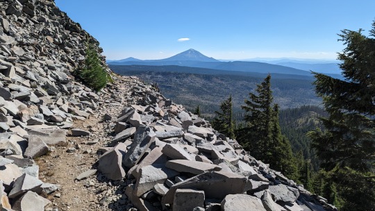
The two Teton Crest trails do not connect, so Owen had downloaded the GPS data from a previous thru-hiker who had bushwhacked a route between the trails. We set off on our bushwhack and it actually started out easier than a lot of the trail we had just done. But it gradually got more and more difficult, climbing steep slopes, rocks, etc. We stopped for a snack when we first got a view of the main three Tetons. Amazing! Only about 1.5 miles to go until we joined the southern Teton Crest Trail. But what a 1.5 it was! First we scrambled over a narrow, rocky ridge. Then we had to basically rock climb down 1200 feet in 0.6 miles. It is definitely the sketchiest thing we have done on trail. Luckily, we made it down safely and set up our tent overlooking Lake Solitude, just in time to shelter from a storm.
The following morning, we were blown away by the immaculate trail and breathtaking scenery on the southern Teton Crest trail. We saw a bull moose grazing right near the trail, then were delighted by waterfalls, mountains, and lush forest. Hurricane Pass was a gorgeous climb, aptly named for the wind. Owen was moved to tears by the beauty. We descended into Alaska Basin, met some Vermonters backpacking through, then climbed Sheep Steppe Pass to get to Death Canyon Shelf. From there, we took a side trail down into Death Canyon. We saw a cow moose and her calf eating dinner. We camped near a lake back down in the low country.
In the morning, we walked out to the road, where traffic was backed up because of a black bear hanging by the road and leisurely eating berries. The ranger and animal control officer waved us through when appropriate. We walked out to the visitor center and hitched into Jackson. A woman picked us up and brought us right to the post office, which was also conveniently near the REI (where I switched to hokas), and the Mexican restaurant that had been recommended to us. Let me tell you, that Mexican restaurant had the best food that we have had on trail! Owen got a giant torta, and I got a burrito with green chili cheese sauce. At the restaurant, Owen overheard two young boys talking about DND. He struck up a conversation, and the parents, Peter and Rachel, offered for us to stay in their backyard that night. When we got there, they actually let us stay in their camper, because it was raining. They gave us some beers, and we came inside to play DND with the boys. What a generous family! In the morning they even drove us back to the trail.
0 notes
Photo

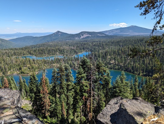
Wind River High Route Day 4: We wake up well before sunrise in the hopes of beating any afternoon weather. After crossing a creek and a small amount of bushwhacking, we're on a well-maintained trail - which makes navigating in the darkness more manageable. Before long we intersect what Continental Divide Trail hikes will know as the Cirque of the Towers Alternate. This stretch of trail is interesting as @simajohnr and I have actually hiked this exact stretch together once before - back in 2017. We make it to Jackass Pass and enter the Cirque of the Towers where we can spy our next objective, New York Pass, nearly directly across from us. After passing a disappointing number of groups camped illegally within the signed, quarter-mile exclusion zone around Lonesome Lake, we start climbing again toward the pass. People. We have some amazing natures in the United States and the regulations/limits surrounding access are generally quite liberal. The rules that are in place are (generally) far from arbitrary and exist for good reason. Don't flout them. /rant New York Pass proves easier than it looked from Jackass Pass and after descending the north side we're back on the trail for a bit. Heading up a valley before again starting cross-country, we cross a bench with some amazing views of a ridgeline with nearly 2,000 ft / 610 m of near-vertical prominence from the valley floor. Don't come to the Winds, they're ugly. Storms are threatening, but we manage to make it over Raid Peak Pass and Sentry Peak Pass before camping near the northern end of Lee Lake south of Photo Pass. It starts to rain as we retreat into our tents - still wet from yesterday despite us finding a short sun window to dry them out today - and prepare for another night of potential downpour. Distance: 23.39 mi / 37.64 km Elevation gain: 6,033 ft / 1,839 m #windriverhighroute #wrhr
0 notes
Link
Check out this listing I just added to my Poshmark closet: Marmot Sz SP PreCip Waterproof Rain/Hiking Pants.
0 notes
Text
Sky Lakes Loop (1/3)
This is my first trip report for a hiking route that I came up with myself!
Most of the backpacking trips I go on are along generally-known routes using itineraries that others have established: whether they're along sections of the PCT, other, local trails, established climber/scramble trails, or some combination of all of those things (like my Three-Fingered Jack trip was), they tend to be routes that are widely known and take place fully along established trails. You can read about them ahead of time online, usually they (or something like them) can be seen on AllTrails, and so on.
Occasionally, I'll do a trip where most of the itinerary is established, but I'll throw in some random bushwhacking and/or other deviations if I'm comfortable enough with the area. For example, when Lindsey and I did a circumnavigation of the Three Sisters in 2018, we were following an established itinerary (and had in fact gotten the idea for the hike originally from some generic "Best Backpacking Trips In the U.S." article online), but we deviated from the route on day two to bushwhack/scramble up, along, and over the eastern shoulder of South Sister rather than taking the trail so we could see the Chambers Lakes (which aren't on a trail, per se) and camp at Camp Lake). This happens to be an example where we were both deviating from the "usual" itinerary and leaving the trail to do so. I don't do this all that often, but one thing I do like to do is use GaiaGPS to find way to knit existing trails together in a way that allows me to do a hike that isn't based on someone else's established itinerary but doesn't require a lot of off-trail routefinding.
Like most wilderness enthusiasts, I have my fair share of misgivings about AllTrails, Facebook, etc. as apps that help drive an unprecedented amount of (often underprepared) hikers to previously "hidden" wilderness areas, but there's also something to be said for their ability to make known places that I (and others) would never have stumbled upon without them, especially if you live in, say, the middle of nowhere in southern Oregon. It's difficult to come down too hard on these apps without feeling like a hypocrite, as I wouldn't have learned about all of my favorite backpacking loops in the Trinities as well as many other routes like the Broken Top Loop without them. It's great in a lot of ways to be able to identify some of the best-regarded hikes in your area in seconds, get up-to-the-day trip reports from other hikers, and know exactly what the trail will be like before you go. The wilderness will still always throw unexpected joys and challenges in your way as you hike; sometimes it's nice to feel like the initial details, at least, are predictable.
That said, there's no real substitute, in my opinion, for the feeling of sitting down with a bunch of maps and nerding out for an hour or two, stitching trails together, measuring mileages and distances between water sources, wincing at elevation gain estimates, and ultimately coming up with an itinerary that's all your own, then going out there and getting to walk it for a few days.
So, the point of this over-long and overly-caffeinated introduction is to set up my trip report for my most recent backpacking in the Sky Lakes Wilderness.
Sky Lakes, besides having the objectively best wilderness area name, is sort of my "home" wilderness. It's just north of Klamath Falls, and hiking into it from the Cold Springs trailhead, where I started this hike from, requires only about a forty-five minute drive from my house. Mountain Lakes Wilderness is actually an even closer drive, but Sky Lakes is a bit more expansive and allows for longer trips. I'm hoping to do an overnight trip into Mountain Lakes later this summer, though, so I'll write about that if/when the time comes.
In addition to having "local" appeal, Sky Lakes is rarely traveled. As you'll hear about later, it was oddly full of people during my most recent visit, but I've been going there for ten years and more often than not encounter literally no other people, unless I'm climbing Mount McLoughlin on a weekend, when you'll typically see 20-30 others over the course of a 6-8 hour hike.
All that said, Sky Lakes sports lots of beautiful trails and (surprise!) a ton of alpine lakes. What it doesn't have, to my knowledge at least, is any "marquee" backpacking routes. So, a few years ago, I made up my own.
Basically, this is a loop hike that encompasses the Heavenly Lakes/Isherwood Lake basin, the Trapper Lake/Marguerette Lake basin, and the Seven Lakes basin. The great thing about this loop is its variety: you can access it at different points from at least four different trailheads, and along the way there are a few variations that you can throw in depending on how far you want to hike, how much you want to climb, and/or how many lakes you want to see. I've done the loop a few times now, and even managed, once, to do it as a sort of figure-eight, which was fun.
Because I'd done the loop a few times before, it was low on my priority list this summer, but two weeks ago everywhere else was smoked out due to some new wildfires both north and south, and yet the K-Falls area had beautiful blue skies. I had a few free days and I realized I'd never done the loop counter-clockwise before. And, honestly, I don't need much more of an excuse than that to hike in the woods for three days at the best of times. So, one forty-five minute drive later, I started north from the Cold Springs trailhead into Sky Lakes.
I've stared this loop from a few of the other trailheads before (Cherry Creek TH, Nannie Creek TH), but they all add a four-to-five-mile "lollipop stick" to the loop, whereas starting from Cold Springs has you on the main loop immediately. The lollipop hikes are beautiful in their own right, but they're all further drives from home, and I felt familiar enough with them from past experience that I was happy to get right to it this time from Cold Springs.

The Cold Springs trail heads north and pretty much immediately enters a burn zone, this one from the 2017 Pelican Fire. It doesn't effect much of the trail and it's one of only two small burn zones along the whole loop. It might be a bit jarring if you aren't used to hiking through burn zones, but who isn't these days? This time of year, there's plenty of regrown understory to gawk at, including an enormous amount of fireweed.
Almost immediately, you hit the wilderness boundary and then an intersection. You can go right or left and stay on the loop either way (basically you are circling the first of three basins here). I went left because I usually go right. I would take the "right-hand" path on the way back two days later. The left turn takes you out of the burn zone quickly, and then past Notasha, Elizabeth, and Isherwood Lakes. Isherwood Lake, in particular, has an awesome camp spot that I always ogle but never camp at because it always falls during a weird part of the hike where it never really makes sense to stop for the night. That was the case here, too, but I stopped briefly to take in the view and drink some water.

From here, the trail loops back around to join up with the "main" Sky Lakes Trail, and I continued north. If you look at a map of the area, there area a ton of off-trail lakes throughout this section of trail. I've never bothered to bushwhack to any of them except for Lake Liza, but I'd love to take the time to do so someday. This time around, I kept heading north, while occasionally catching blue glimpses of the rogue lakes to my left and right.
The trail climbs a little over the next few miles as you head toward the Trapper Lake basin, but it's nothing unmanageable. This is also one of the few parts of the trail you have to repeat if doing the entire loop: there's only one trail that joins these two lake basins, which means you've got to deal with it twice. It's not bad, though, and quickly enough you're at one of my favorite lakes in the entire loop: Trapper Lake.
I'd share a photo of this now, but since I cross-post to Instagram and it only allows ten photos, I'll save my Trapper photos for when I write up days two and three of the hike. Suffice to say it's pretty great.
In the past, I've always gone "right"/northeast from this basin to continue onto the next portion of the loop, so this time I mixed things up and went "left"/northwest instead. This actually takes you south for a bit as you wind around below the cliffs that tower above Trapper Lake and past some smaller lakes (including the named Lake No-See-Um and some unnamed ones too). Then you start the first "legit" (take that however you want) climb of the trip.
In total, you gain about eight-hundred feet here. You're in the shade of the forest for the first half, but the second part is pretty exposed. Fortunately, it's beautiful in a particularly southern Oregon way. Once you've climbed about four hundred feet, you'll realize that you're standing on the cliffs you saw previously from below, and you can look down from above and understand how Sky Lakes got its name.
From here, you continue to climb and somewhere along the way the wilderness takes on a much more alpine character. After some particularly steep switchbacks, Mount McLoughlin comes into view for the first time.

Shortly after this, you merge onto the PCT to continue heading north. Though it isn't named, this a pass of sorts, as you top out on the western shoulder of Luther Mountain. If you like punishing yourself for some reason, you can summit Luther Mountain from here; while the approach is really steep and loose, it's obvious and "easy" to follow, and it's certainly the easiest way to summit the mountain if you have to. I did it five years or so ago and wouldn't recommend the experience.
Anyway, on the PCT I almost immediately started crossing paths with some thru-hikers, all of whom stopped to chat and assumed that I was also a thru-hiker, heading north. Not true, but it always feels good to pass as someone capable of hiking 2,600 miles nonstop, even though I'm not.
The first stretch of the PCT here takes you through the loop's other burn zone, much of which burnt twice in 2014 due to two different fires. Like the burn zone near Cold Springs, though, this one has had some time to grow back, and with the fireweed and wide open views of the surrounding mountains in all directions, it's actually one of my favorite parts of the loop.

Right before you exit the burn area, there is an intersection with the excellently-named Snow Lakes Trail, which I planned to pick up on my way back through the second half of the loop the next afternoon. For now, I took a break in a small patch of shade next to the trail sign, then continued north on the PCT.
This section traverses along a steep ridge for a bit, with some excellent views off to the west, before passing right underneath the summit of Shale Butte. You can scramble up this one, too, and if you like scrambling on shale plates, this is a pretty short climb for a solid payoff. Otherwise, you continue north beneath the intensely-named Lucifer Peak and then come to an intersection where either right or left can eventually get you to the Seven Lakes Basin, the third of the three basins along the loop and the northern "top" of the loop.

Again, I usually go right here, so instead I went left. You pass underneath two more named summits - Jupiter and Venus - here and then you come to an intersection with the Seven Lakes Trail.
Fun aside (because there haven't been enough of those in this post already): if you're of the peak-bagging persuasion and aren't adverse to a little off-trail scrambling, you can approach the basin via this trail and, instead of descending into it, follow along the ridgeline and climb seven peaks in one day. I did this once way back when and got six of the named highpoints before a downpour forced me to head back to the car instead of climbing Violet Hill, which would have been the seventh.
On this particular day, I was descending into the basin instead of bagging summits, so I went east. From this intersection, you descend pretty quickly into a beautiful alpine pine forest, and continue descending through mixed forest and rockpiles before reaching the first of the seven lakes of the Seven Lakes Basin: South Lake.
South Lake is nice, but I bypassed it quickly enough in favor of Cliff Lake, which was my goal for the night. Every time I'd done this loop in the past, I'd spent one of the nights at Cliff Lake: it's a beautiful lake with a great view of the looming Devil's Peak, and a number of fantastic campsites.

I've always had the place more or less to myself in the past, so I was surprised to find upon rolling up that every single campsite I knew of was already occupied for the night. I even headed to the southern shore of the lake, where there is a campsite that is kinda-sorta-but-maybe-not "CLOSED FOR RESTORATION," thinking of that spot as a last resort, but was immediately chased away by two huge, off-leash dogs belonging to a couple who was camped directly underneath the "CLOSED" sign. Huh.
I was pretty dispirited by this turn of events. Of course, wilderness is equally open to everyone's use, but I was surprised that every spot around the lake was taken.
At this point, it was about two hours until sunset, and with the choice to either a) double back to South Lake or b) continue on, I chose to continue on. I'd planned to take a dayhike the next morning to the off-the-beaten-path Lake Ivern, and so I decided I would just start walking in that direction now instead and see what happened.
What happened was that I pretty quickly came upon Middle Lake, and some open camp spots there, but at that point I had in my head that I was going to hike all the way to Ivern and camp there. This would turn out to be a mistake. For the time being, I noted the best Middle Lake campsite mentally and pushed on to Ivern.
The hike through this section of trail was pretty interesting. As someone who knows the main parts of the this loop more or less by heart at this point, I found the character of the Lake Ivern trail to be different. It mostly descends toward the lake through deep forest, past a number of springs that trickle down from the west and run across the trail. There were huckleberry and whortleberry bushes everywhere, and I grabbed and ate a bunch of both as I walked, already racing the sunset and not wanting to stop and fish a snack out of my pack.
All in all, it was a really idyllic though somewhat forced two-mile march, so I was surprised when I reached the lake proper to find it to be shallow, scummy, and surrounded by a combination of old snags and burnt, dead trees. There was one campsite there, but it was oddly sloped and the surrounding area was depressing to look at in a way that I don't normally encounter out in the wild. I had been out of water for a long time, so I had to fill one bottle in the scummy lake, but I didn't relish the idea of taking all of my drinking and cooking water until the next afternoon out of it.
Had it been an emergency situation, I could definitely have stayed there with little trouble, but with another hour left until sunset, I grudgingly did what seemed like the obvious thing: hiked back up the Lake Ivern trail back to Middle Lake.
The silver lining and the conclusion of this much-too-long post is that on the way back to Middle Lake, I noticed, in the failing light, a campsite that was much better than any of the others I'd seen when I'd passed through earlier. Not only was this spot a bit further off the trail than the others, it also featured a footpath that provided easy access to the (clean) lake, and a great view of Devil's Peak in the distance.
I didn't get to said camp spot until dark, which meant I had to set up camp, cook, and sort and store all of my gear in the dark, but this was far from the first time I've had to do that, and it was much warmer than it had been those other times.
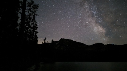
In the end, I had a nice, relaxing dinner, and even took the time to take some astrophotos of the lake, the mountain, and the stars.
I'd planned to hike fourteen miles from Cold Springs to Cliff Lake on this first day, but due to some digressions and the added mileage to and from Lake Ivern, my GPS ended up counting twenty-one miles...the most I've ever hiked in one day with a full backpacking pack. Fortunately, the terrain is Sky Lakes is a little more forgiving than say, in the Trinities or the Wallowas, where twenty-one miles is an entirely different proposition. That said, I fell asleep pretty much the moment I laid down in the tent. Tomorrow, I hoped, would be a little more straightforward.
#backpacking#hiking#camping#photos#traveling#mountains#alpine lakes#sky lakes wilderness#southern oregon
0 notes
Last Seen Blogs

trrrracey
Scrappy Like a Fox

loveprincesslove
Princesslove

ortizenevoldsen75
The Love of Kring 296

xedaptaptheduc-blog1
Xe đạp tập thể dục

indigo-o
INDIGO