#colonialvirginia
Text
Traveling from Fredericksburg to Dumfries: The “Great Public Evil” of the 18th & 19th centuries
By: Lisa Timmerman, Executive Director
By all accounts, Mason Locke Weems was a shrewd salesman as he traveled up and down Virginia selling his books. Roads were certainly a concern of early Americans in the 1790s as the conditions frequently and significantly delayed travel. Historical letters abound bemoaning the roads around Dumfries as weather, season, temperature, and river levels all had to be accounted before when planning an excursion. Weems petitioned Virginia’s General Assembly on 12/16/1797 with a creative solution.
“The petition of Mason Locke Weems, humbly shewth, That the delay of the Mail, and the great risques which often alarm and which sometimes have actually destroyed the lives and property of Travellers on the post road from Fredericksburg to Dumfries, for want of bridges over the deep and rapid runs of Potomak and Acquia, are to be conditioned as great public evils; and that your petitioner of the most valuable books, the circulation of which he concieves [sic] will greatly redound to gracious permission, to undertake a lottery for the disposal of books which he will furnish to the fortunate adventurers in said lottery, at the Philadelphia retail prices, and from the profits of which books that vended, he will contribute one thousand dollars for the purpose of erecting over the aforesaid dangerous runs of Potomak & Acquia, two strong and sufficient bridges, of season’d oak frames well tard, and secured from the inclemencies of the Weather. Your Petitioner therefore humbly prayeth that an act may pass to authorize such a lottery and to appoint commissioners to raise by lottery the sum of one thousand dollars, for the purpose of building the aforesaid bridges, and your Petitioner will as in duty bound pray &c.”

(Fry, Joshua. A map of the most inhabited part of Virginia containing the whole province of Maryland with part of Pensilvania, New Jersey and North Carolina. [1775], Library of Congress, http://hdl.loc.gov/loc.gmd/g3880.ct000370)
While the good Parson certainly condemned vices such as drinking and gambling in his works, lotteries held a slightly different connotation in the late 1700s. Lotteries were crucial to the very first years of the Jamestown colony when the Virginia Company held a lottery in 1612 to raise additional funding for the struggling colonists. Thomas Sharplisse, a London tailor, won the grand prize of four thousand crowns with two Anglican churches receiving smaller fortunes. After covering the costs of the lotteries, the Virginia Company directed the remaining revenue to their desperate colonists. Early Americans continued to rely upon these “public benefits,” as the administrators of the lotteries used careful phrasing to gain public support and funds. Many Virginia planter patriarchs, such as George Washington, participated in lotteries for personal and public benefits. William Smith wrote to George Washington on 08/13/1784 asking for his help in disseminating tickets for funding Washington College. While he had circulated a subscription letter to possible donors, he also wanted to offer a lottery. “With the Advice of Govr Paca & others of the Visitors, we have also a Lottery on Foot, which may be at least an excusable Means of drawing some Aid from some, whose public Spirit might not otherwise induce them to subscribe. Enclosed is the Scheme of the Lottery, which we have Reason to hope may be full by Novr the Time mentioned.” Washington agreed noting David Ardell would carry out the distribution. “I do not know where two or three hundred could be better placed in Alexandria, & if you will send him that number, he has promised me that his ex[er]tion for the sale of them shall not be wanting.” The result? Out of the 10,000 tickets at four dollars a piece offered by The Washington College, 3,187 won prizes – 3,000 paid eight dollars and the other 187 up to four dollars. Archibald Thweatt made a similar suggestion to Thomas Jefferson on 09/24/1817 after receiving a subscription letter from him for Jefferson’s “Central College” in Charlottesville.
However, careful phrasing and good motives did not stop corruption and fraud. Britain banned private lotteries in 1769, but that did not stop public lotteries from resuming years later. Purchasers felt confident that their money overall helped society and allowed them brief entertainment with this game of chance. When King George III prohibited lotteries in almost all colonies, tensions immediately increased as colonists used lotteries as a way to avoid taxes. It should be noted that the English State Lottery, run by the British, remained legal with serious modifications to allow more money to remain with the British collectors. Lotteries remained in favor until around the 1830s when lottery scams, continued religious outcry (Quakers were notable very early dissenters), and social reform movements changed Americans opinions.
Weems’ 1797 petition came at a time when lotteries were still favorable in Virginia and across the country. His emphasis on books and the desire to make traveling safer not only appealed to those in favor of supporting education, it also spoke to better commerce and networking with easier transportation and travel. However, there would be no special lottery for our Potomac and Aquia rivers. The Virginia General Assembly rejected his request. Nevertheless, he purchased our humble museum the following year in 1798 as he continued risking his life to the “great public evil” of Virginia – our roads.
(Sources: Weems, Mason Locke. Petition, 1797. LVA: Legislative Petitions Digital Collection; Laskow, Sarah. Colonial America was Built on Lottery Revenue. Atlas Obscura, https://www.atlasobscura.com/articles/early-american-lottery-ticket-colonial; Sweeney, Matthew. The Lottery Wars: Long Odds, Fast Money, and the Battle Over an American Institution. London: Bloomsbury, 2009; “Archibald Thweatt to Thomas Jefferson, 24 September 1817,” Founders Online, National Archives, https://founders.archives.gov/documents/Jefferson/03-12-02-0033. [Original source: The Papers of Thomas Jefferson, Retirement Series, vol. 12, 1 September 1817 to 21 April 1818, ed. J. Jefferson Looney. Princeton: Princeton University Press, 2014, pp. 41–42.]; “To George Washington from William Smith, 13 August 1784,” Founders Online, National Archives, https://founders.archives.gov/documents/Washington/04-02-02-0037. [Original source: The Papers of George Washington, Confederation Series, vol. 2, 18 July 1784 – 18 May 1785, ed. W. W. Abbot. Charlottesville: University Press of Virginia, 1992, pp. 37–38.]; “From George Washington to William Smith, 25 August 1784,” Founders Online, National Archives, https://founders.archives.gov/documents/Washington/04-02-02-0053. [Original source: The Papers of George Washington, Confederation Series, vol. 2, 18 July 1784 – 18 May 1785, ed. W. W. Abbot. Charlottesville: University Press of Virginia, 1992, p. 57.])
Note: Start your Saturday with excellent fiction, tea, and conversation! Tickets are still available for our virtual Weems-Botts Bibliophiles program featuring dark fantasy and Leaf & Petal’s Blood Orange Smoothie Tea. Enjoy the delectable taste of creamsicle as we discuss some of the more controversial and fascinating stories from the early 1900s! Tickets available here.
#localhistory#virginiaroads#travel#community#parsonweems#colonialvirginia#historyofvirginia#lotteries#regionalhistory#badroads#primarysources#petitions#virginiageneralassembly
1 note
·
View note
Photo

Daily Waypoint | N 37° 16′ 16.50″ W 76° 42′ 0.00″ James Craig Jeweller Shop—Seen at Colonial Williamsburg a living-history museum and private foundation presenting part of an historic district in the city of Williamsburg, Virginia. Colonial Williamsburg's 301-acre Historic Area includes buildings from the 18th century (during part of which the city was the capital of Colonial Virginia), as well as 17th-century, 19th-century, and Colonial Revival structures, as well as more recent reconstructions. The Historic Area is an interpretation of a colonial American city, with exhibits of dozens of restored or re-created buildings related to its colonial and American Revolutionary War history. One of the largest history projects in the nation and a tourist attraction, it is part of the Historic Triangle of Virginia, which includes Jamestown and Yorktown, linked by the Colonial Parkway. It was designated a National Historic Landmark District in 1960. Costumed employees work and dress as people did in the era, sometimes using colonial grammar and diction. Prominent buildings include the Raleigh Tavern, the Capitol, the Governor's Palace, as well as the Courthouse, the George Wythe House, the Peyton Randolph House, the Magazine, and independently owned and functioning Bruton Parish Church. Colonial Williamsburg's portion of the Historic Area begins east of the College of William & Mary's College Yard. https://www.fmgphoto.com/Feature-Special-Galleries/n-W7xDfN/Colonial-Williamsburg/i-pGS8dpr/A https://followingmygps.com/colonial-williamsburg/ #ColonialWilliamsburg #WilliamsburgVirginia #livinghistorymuseum #museum #Colonial #ColonialVirginia #HistoricTriangle #Colonialcapital #HistoricLandmark #jamescraigjeweller #colonialwilliamsburgva #colonialjewellery #discoveramerica #travelpics #travellife #travelinspiration #travelblog #travelphotography #fmgphoto #followingmygps #travelphotography #traveller #photography #travelamerica #lifestyle #LifeWellLived #travelmagazine #roadtripping #exploring #roadtrip (at Colonial Williamsburg) https://www.instagram.com/p/CD606Y3MKjA/?igshid=je3n1szet38f
#colonialwilliamsburg#williamsburgvirginia#livinghistorymuseum#museum#colonial#colonialvirginia#historictriangle#colonialcapital#historiclandmark#jamescraigjeweller#colonialwilliamsburgva#colonialjewellery#discoveramerica#travelpics#travellife#travelinspiration#travelblog#travelphotography#fmgphoto#followingmygps#traveller#photography#travelamerica#lifestyle#lifewelllived#travelmagazine#roadtripping#exploring#roadtrip
1 note
·
View note
Photo

Colonial Williamsburg! #williamsburgva #williamsburg #colonialvirginia #virginia #vaisforlovers #virginiaisforlovers❤️ #nikon #nikonphoto #nikonphotography #nikond7200
#williamsburg#nikon#colonialvirginia#nikonphoto#vaisforlovers#nikond7200#williamsburgva#virginia#virginiaisforlovers❤️#nikonphotography
5 notes
·
View notes
Photo
#Repost @stanleyprestonlewis ・・・ The charming Peter Hay’s Kitchen is my home-away-from-home in Williamsburg for the next few days. Dr. Peter Hay was a doctor-apothecary who sold drugs and sundries from his shop on the corner of Duke of Gloucester and Queen streets in the 1740’s. Peter Hay’s Kitchen is one of the Colonial Houses Historic Lodging properties available from @cwresorts I enjoyed a crackling wood fire on this chilly evening that was expertly tended to by @mhedge1776 , a Williamsburg resident and Instagram friend who stopped by for a visit. #peterhaykitchen #colonialhouseshistoriclodging #cwresorts #williamsburgva #18thcenturyarchitecture #colonialvirginia #colonyofvirginia #colonialhouse #cozybythefire #woodfire https://instagr.am/p/CY4mBZJP75s/
7 notes
·
View notes
Photo

#TBT to November 1989, Thanksgiving family visit to Colonial Williamsburg! #williamsburg #throwbackthursday #virginia #localhistory #historic #colonialvirginia #colonialhistory #1980s #1989 #colonialwilliamsburg (at Colonial Williamsburg)
#colonialhistory#virginia#tbt#1989#colonialvirginia#localhistory#throwbackthursday#williamsburg#historic#1980s#colonialwilliamsburg
0 notes
Quote
Built in the days when Virginia was a man's world, when men who wore satin, velvet and damask were masters of the art of fighting, riding, drinking, eating, and wooing. When a man knew what he wanted, and got it by God's help and his own tenacity, enjoying himself right lustily in the getting. Perchance Major John Carlyle, clad in Saxon green laced with silver, will be wandering up and down his box-bordered paths with his first love, Sarah Fairfax, watching the moon light up the rigging of Carlyle & Dalton's great ships at anchor just at the foot of the garden.
from Seaport in Virginia: George Washington's Alexandria by Gay Montague Moore
0 notes
Photo
Daily Waypoint | N 37° 16′ 16.50″ W 76° 42′ 0.00″ Colonial Williamsburg Town Folk—Colonial Williamsburg is a living-history museum and private foundation presenting part of an historic district in the city of Williamsburg, Virginia. Colonial Williamsburg's 301-acre Historic Area includes buildings from the 18th century (during part of which the city was the capital of Colonial Virginia), as well as 17th-century, 19th-century, and Colonial Revival structures, as well as more recent reconstructions. The Historic Area is an interpretation of a colonial American city, with exhibits of dozens of restored or re-created buildings related to its colonial and American Revolutionary War history. One of the largest history projects in the nation and a tourist attraction, it is part of the Historic Triangle of Virginia, which includes Jamestown and Yorktown, linked by the Colonial Parkway. It was designated a National Historic Landmark District in 1960. Costumed employees work and dress as people did in the era, sometimes using colonial grammar and diction. Prominent buildings include the Raleigh Tavern, the Capitol, the Governor's Palace, as well as the Courthouse, the George Wythe House, the Peyton Randolph House, the Magazine, and independently owned and functioning Bruton Parish Church. Colonial Williamsburg's portion of the Historic Area begins east of the College of William & Mary's College Yard. https://www.fmgphoto.com/Feature-Special-Galleries/n-W7xDfN/Colonial-Williamsburg/i-rHhpBmK/A https://followingmygps.com/colonial-williamsburg/ #ColonialWilliamsburg #WilliamsburgVirginia #livinghistorymuseum #museum #Colonial #ColonialVirginia #HistoricTriangle #Colonialcapital #HistoricLandmark #GovernorsPalace #coloniallife #historicalreenactment #discoveramerica #travelpics #travellife #travelinspiration #travelblog #travelphotography #fmgphoto #followingmygps #travelphotography #traveller #photography #travelamerica #lifestyle #LifeWellLived #travelmagazine #roadtripping #exploring #roadtrip (at Colonial Williamsburg) https://www.instagram.com/p/CCLsvmasGqE/?igshid=1w0hl8mwzsf08
#colonialwilliamsburg#williamsburgvirginia#livinghistorymuseum#museum#colonial#colonialvirginia#historictriangle#colonialcapital#historiclandmark#governorspalace#coloniallife#historicalreenactment#discoveramerica#travelpics#travellife#travelinspiration#travelblog#travelphotography#fmgphoto#followingmygps#traveller#photography#travelamerica#lifestyle#lifewelllived#travelmagazine#roadtripping#exploring#roadtrip
1 note
·
View note
Photo
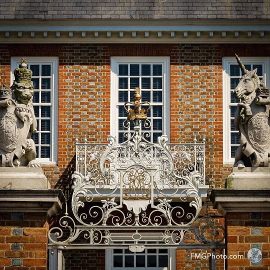
Daily Waypoint | N 37° 16′ 16.50″ W 76° 42′ 0.00″ Lion and Unicorn Stand Guard at the Governor's Palace—Colonial Williamsburg is a living-history museum and private foundation presenting part of an historic district in the city of Williamsburg, Virginia. Colonial Williamsburg's 301-acre Historic Area includes buildings from the 18th century (during part of which the city was the capital of Colonial Virginia), as well as 17th-century, 19th-century, and Colonial Revival structures, as well as more recent reconstructions. The Historic Area is an interpretation of a colonial American city, with exhibits of dozens of restored or re-created buildings related to its colonial and American Revolutionary War history. One of the largest history projects in the nation and a tourist attraction, it is part of the Historic Triangle of Virginia, which includes Jamestown and Yorktown, linked by the Colonial Parkway. It was designated a National Historic Landmark District in 1960. Costumed employees work and dress as people did in the era, sometimes using colonial grammar and diction. Prominent buildings include the Raleigh Tavern, the Capitol, the Governor's Palace, as well as the Courthouse, the George Wythe House, the Peyton Randolph House, the Magazine, and independently owned and functioning Bruton Parish Church. Colonial Williamsburg's portion of the Historic Area begins east of the College of William & Mary's College Yard.—This image was processed as an HDR (High Dynamic Range) composition. https://www.fmgphoto.com/Feature-Special-Galleries/n-W7xDfN/Colonial-Williamsburg/i-WT7ZTKc/A https://followingmygps.com/colonial-williamsburg/ #ColonialWilliamsburg #WilliamsburgVirginia #livinghistorymuseum #museum #Colonial #ColonialVirginia #HistoricTriangle #Colonialcapital #HistoricLandmark #GovernorsPalace #lionandunicorn #HDR #discoveramerica #travelpics #travellife #travelinspiration #travelblog #travelphotography #fmgphoto #followingmygps #travelphotography #traveller #photography #travelamerica #lifestyle #LifeWellLived #travelmagazine #roadtripping #exploring #roadtrip (at Colonial Williamsburg) https://www.instagram.com/p/CDq9XuQsH8t/?igshid=ff671v4cfia0
#colonialwilliamsburg#williamsburgvirginia#livinghistorymuseum#museum#colonial#colonialvirginia#historictriangle#colonialcapital#historiclandmark#governorspalace#lionandunicorn#hdr#discoveramerica#travelpics#travellife#travelinspiration#travelblog#travelphotography#fmgphoto#followingmygps#traveller#photography#travelamerica#lifestyle#lifewelllived#travelmagazine#roadtripping#exploring#roadtrip
0 notes
Photo

Daily Waypoint | N 37° 16′ 16.50″ W 76° 42′ 0.00″ Capital Building Council Chamber—Colonial Williamsburg is a living-history museum and private foundation presenting part of an historic district in the city of Williamsburg, Virginia. Colonial Williamsburg's 301-acre Historic Area includes buildings from the 18th century (during part of which the city was the capital of Colonial Virginia), as well as 17th-century, 19th-century, and Colonial Revival structures, as well as more recent reconstructions. The Historic Area is an interpretation of a colonial American city, with exhibits of dozens of restored or re-created buildings related to its colonial and American Revolutionary War history. One of the largest history projects in the nation and a tourist attraction, it is part of the Historic Triangle of Virginia, which includes Jamestown and Yorktown, linked by the Colonial Parkway. It was designated a National Historic Landmark District in 1960. Costumed employees work and dress as people did in the era, sometimes using colonial grammar and diction. Prominent buildings include the Raleigh Tavern, the Capitol, the Governor's Palace, as well as the Courthouse, the George Wythe House, the Peyton Randolph House, the Magazine, and independently owned and functioning Bruton Parish Church. Colonial Williamsburg's portion of the Historic Area begins east of the College of William & Mary's College Yard. https://www.fmgphoto.com/Feature-Special-Galleries/n-W7xDfN/Colonial-Williamsburg/i-J6KZHzp/A https://followingmygps.com/colonial-williamsburg/ #ColonialWilliamsburg #WilliamsburgVirginia #livinghistorymuseum #museum #Colonial #ColonialVirginia #HistoricTriangle #Colonialcapital #HistoricLandmark #GovernorsPalace #CapitalBuilding #councilchamber #discoveramerica #travelpics #travellife #travelinspiration #travelblog #travelphotography #fmgphoto #followingmygps #travelphotography #traveller #photography #travelamerica #lifestyle #LifeWellLived #travelmagazine #roadtripping #exploring #roadtrip (at Colonial Williamsburg) https://www.instagram.com/p/CCa8UmcsX3l/?igshid=ypg1poa0qocw
#colonialwilliamsburg#williamsburgvirginia#livinghistorymuseum#museum#colonial#colonialvirginia#historictriangle#colonialcapital#historiclandmark#governorspalace#capitalbuilding#councilchamber#discoveramerica#travelpics#travellife#travelinspiration#travelblog#travelphotography#fmgphoto#followingmygps#traveller#photography#travelamerica#lifestyle#lifewelllived#travelmagazine#roadtripping#exploring#roadtrip
0 notes
Photo

Daily Waypoint | N 37° 16′ 16.50″ W 76° 42′ 0.00″ Colonial Williamsburg Print Shop—Colonial Williamsburg is a living-history museum and private foundation presenting part of an historic district in the city of Williamsburg, Virginia. Colonial Williamsburg's 301-acre Historic Area includes buildings from the 18th century (during part of which the city was the capital of Colonial Virginia), as well as 17th-century, 19th-century, and Colonial Revival structures, as well as more recent reconstructions. The Historic Area is an interpretation of a colonial American city, with exhibits of dozens of restored or re-created buildings related to its colonial and American Revolutionary War history. One of the largest history projects in the nation and a tourist attraction, it is part of the Historic Triangle of Virginia, which includes Jamestown and Yorktown, linked by the Colonial Parkway. It was designated a National Historic Landmark District in 1960. Costumed employees work and dress as people did in the era, sometimes using colonial grammar and diction. Prominent buildings include the Raleigh Tavern, the Capitol, the Governor's Palace, as well as the Courthouse, the George Wythe House, the Peyton Randolph House, the Magazine, and independently owned and functioning Bruton Parish Church. Colonial Williamsburg's portion of the Historic Area begins east of the College of William & Mary's College Yard. https://www.fmgphoto.com/Feature-Special-Galleries/n-W7xDfN/Colonial-Williamsburg/i-5zBkQC6/A https://followingmygps.com/colonial-williamsburg/ #ColonialWilliamsburg #WilliamsburgVirginia #livinghistorymuseum #museum #Colonial #ColonialVirginia #HistoricTriangle #Colonialcapital #HistoricLandmark #GovernorsPalace #printshop #letterpress #discoveramerica #travelpics #travellife #travelinspiration #travelblog #travelphotography #fmgphoto #followingmygps #travelphotography #traveller #photography #travelamerica #lifestyle #LifeWellLived #travelmagazine #roadtripping #exploring #roadtrip (at Colonial Williamsburg) https://www.instagram.com/p/CBdiuL2Dil4/?igshid=4vbyoaefl026
#colonialwilliamsburg#williamsburgvirginia#livinghistorymuseum#museum#colonial#colonialvirginia#historictriangle#colonialcapital#historiclandmark#governorspalace#printshop#letterpress#discoveramerica#travelpics#travellife#travelinspiration#travelblog#travelphotography#fmgphoto#followingmygps#traveller#photography#travelamerica#lifestyle#lifewelllived#travelmagazine#roadtripping#exploring#roadtrip
0 notes
Photo

Daily Waypoint | N 37° 16′ 16.50″ W 76° 42′ 0.00″ Colonial Williamsburg Governor's Palace—Colonial Williamsburg is a living-history museum and private foundation presenting part of an historic district in the city of Williamsburg, Virginia. Colonial Williamsburg's 301-acre Historic Area includes buildings from the 18th century (during part of which the city was the capital of Colonial Virginia), as well as 17th-century, 19th-century, and Colonial Revival structures, as well as more recent reconstructions. The Historic Area is an interpretation of a colonial American city, with exhibits of dozens of restored or re-created buildings related to its colonial and American Revolutionary War history. One of the largest history projects in the nation and a tourist attraction, it is part of the Historic Triangle of Virginia, which includes Jamestown and Yorktown, linked by the Colonial Parkway. It was designated a National Historic Landmark District in 1960. Costumed employees work and dress as people did in the era, sometimes using colonial grammar and diction. Prominent buildings include the Raleigh Tavern, the Capitol, the Governor's Palace, as well as the Courthouse, the George Wythe House, the Peyton Randolph House, the Magazine, and independently owned and functioning Bruton Parish Church. Colonial Williamsburg's portion of the Historic Area begins east of the College of William & Mary's College Yard.—This image was processed as an HDR (High Dynamic Range) composition. https://www.fmgphoto.com/Feature-Special-Galleries/n-W7xDfN/Colonial-Williamsburg/i-fm5ngQq/A https://followingmygps.com/colonial-williamsburg/ #ColonialWilliamsburg #WilliamsburgVirginia #livinghistorymuseum #museum #Colonial #ColonialVirginia #HistoricTriangle #Colonialcapital #HistoricLandmark #GovernorsPalace #HDR #Architecture #discoveramerica #travelpics #travellife #travelinspiration #travelblog #travelphotography #fmgphoto #followingmygps #travelphotography #traveller #photography #travelamerica #lifestyle #LifeWellLived #travelmagazine #roadtripping #exploring #roadtrip (at Colonial Williamsburg) https://www.instagram.com/p/B_jTK59jmqj/?igshid=1a4ysfqi75t9r
#colonialwilliamsburg#williamsburgvirginia#livinghistorymuseum#museum#colonial#colonialvirginia#historictriangle#colonialcapital#historiclandmark#governorspalace#hdr#architecture#discoveramerica#travelpics#travellife#travelinspiration#travelblog#travelphotography#fmgphoto#followingmygps#traveller#photography#travelamerica#lifestyle#lifewelllived#travelmagazine#roadtripping#exploring#roadtrip
0 notes
Photo

Daily Waypoint | N 37° 16′ 16.50″ W 76° 42′ 0.00″ Colonial Lock—Seen at Colonial Williamsburg a living-history museum and private foundation presenting part of an historic district in the city of Williamsburg, Virginia. Colonial Williamsburg's 301-acre Historic Area includes buildings from the 18th century (during part of which the city was the capital of Colonial Virginia), as well as 17th-century, 19th-century, and Colonial Revival structures, as well as more recent reconstructions. The Historic Area is an interpretation of a colonial American city, with exhibits of dozens of restored or re-created buildings related to its colonial and American Revolutionary War history. One of the largest history projects in the nation and a tourist attraction, it is part of the Historic Triangle of Virginia, which includes Jamestown and Yorktown, linked by the Colonial Parkway. It was designated a National Historic Landmark District in 1960. Costumed employees work and dress as people did in the era, sometimes using colonial grammar and diction. Prominent buildings include the Raleigh Tavern, the Capitol, the Governor's Palace, as well as the Courthouse, the George Wythe House, the Peyton Randolph House, the Magazine, and independently owned and functioning Bruton Parish Church. Colonial Williamsburg's portion of the Historic Area begins east of the College of William & Mary's College Yard. https://www.fmgphoto.com/Feature-Special-Galleries/n-W7xDfN/Colonial-Williamsburg/i-kGpGKRK/A https://followingmygps.com/colonial-williamsburg/ #ColonialWilliamsburg #Williamsburg #Virginia #livinghistorymuseum #museum #Colonial #ColonialVirginia #HistoricTriangle #Colonialcapital #HistoricLandmark #GovernorsPalace #RaleighTavern #Silversmith #Architecture #building #travelinspiration #travelblog #travelphotography #fmgphoto #followingmygps #fmg #fmgbear #photography #travelamerica #lifestyle #LifeWellLived #travelmagazine #roadtripping #exploring #roadtrip (at Colonial Williamsburg) https://www.instagram.com/p/B-Zg_FuDJ3F/?igshid=1bw4fytx56to0
#colonialwilliamsburg#williamsburg#virginia#livinghistorymuseum#museum#colonial#colonialvirginia#historictriangle#colonialcapital#historiclandmark#governorspalace#raleightavern#silversmith#architecture#building#travelinspiration#travelblog#travelphotography#fmgphoto#followingmygps#fmg#fmgbear#photography#travelamerica#lifestyle#lifewelllived#travelmagazine#roadtripping#exploring#roadtrip
0 notes
Photo

Daily Waypoint | N 37° 16′ 16.50″ W 76° 42′ 0.00″ Silversmith's Workshop—Seen at Colonial Williamsburg a living-history museum and private foundation presenting part of an historic district in the city of Williamsburg, Virginia. Colonial Williamsburg's 301-acre Historic Area includes buildings from the 18th century (during part of which the city was the capital of Colonial Virginia), as well as 17th-century, 19th-century, and Colonial Revival structures, as well as more recent reconstructions. The Historic Area is an interpretation of a colonial American city, with exhibits of dozens of restored or re-created buildings related to its colonial and American Revolutionary War history. One of the largest history projects in the nation and a tourist attraction, it is part of the Historic Triangle of Virginia, which includes Jamestown and Yorktown, linked by the Colonial Parkway. It was designated a National Historic Landmark District in 1960. Costumed employees work and dress as people did in the era, sometimes using colonial grammar and diction. Prominent buildings include the Raleigh Tavern, the Capitol, the Governor's Palace, as well as the Courthouse, the George Wythe House, the Peyton Randolph House, the Magazine, and independently owned and functioning Bruton Parish Church. Colonial Williamsburg's portion of the Historic Area begins east of the College of William & Mary's College Yard. https://www.fmgphoto.com/Feature-Special-Galleries/n-W7xDfN/Colonial-Williamsburg/i-JkF5fLR/A https://followingmygps.com/colonial-williamsburg/ #ColonialWilliamsburg #Williamsburg #Virginia #livinghistorymuseum #museum #Colonial #ColonialVirginia #HistoricTriangle #Colonialcapital #HistoricLandmark #GovernorsPalace #RaleighTavern #Silversmith #Architecture #building #travelinspiration #travelblog #travelphotography #fmgphoto #followingmygps #fmg #fmgbear #photography #travel #lifestyle #LifeWellLived #travelmagazine #roadtripping #exploring #roadtrip (at Colonial Williamsburg) https://www.instagram.com/p/B-E26uGBb-b/?igshid=1ho5n435anapq
#colonialwilliamsburg#williamsburg#virginia#livinghistorymuseum#museum#colonial#colonialvirginia#historictriangle#colonialcapital#historiclandmark#governorspalace#raleightavern#silversmith#architecture#building#travelinspiration#travelblog#travelphotography#fmgphoto#followingmygps#fmg#fmgbear#photography#travel#lifestyle#lifewelllived#travelmagazine#roadtripping#exploring#roadtrip
0 notes
Photo

Daily Waypoint | N 37° 16′ 16.50″ W 76° 42′ 0.00″ Colonial Williamsburg Reenactors—Colonial Williamsburg is a living-history museum and private foundation presenting part of a historic district in the city of Williamsburg, Virginia. Colonial Williamsburg's 301-acre Historic Area includes buildings from the 18th century (during part of which the city was the capital of Colonial Virginia), as well as 17th-century, 19th-century, and Colonial Revival structures, as well as more recent reconstructions. The Historic Area is an interpretation of a colonial American city, with exhibits of dozens of restored or re-created buildings related to its colonial and American Revolutionary War history. One of the largest history projects in the nation and a tourist attraction, it is part of the Historic Triangle of Virginia, which includes Jamestown and Yorktown, linked by the Colonial Parkway. It was designated a National Historic Landmark District in 1960. Costumed employees work and dress as people did in the era, sometimes using colonial grammar and diction. Prominent buildings include the Raleigh Tavern, the Capitol, the Governor's Palace, as well as the Courthouse, the George Wythe House, the Peyton Randolph House, the Magazine, and independently owned and functioning Bruton Parish Church. Colonial Williamsburg's portion of the Historic Area begins east of the College of William & Mary's College Yard. >>>FMG>>>> Like. Comment. Share! https://www.fmgphoto.com/Feature-Special-Galleries/n-W7xDfN/Colonial-Williamsburg/i-n5L8Mf6/A https://followingmygps.com/colonial-williamsburg/ #ColonialWilliamsburg #Williamsburg #Virginia #livinghistorymuseum #museum #Colonial #ColonialVirginia #HistoricTriangle #Colonialcapital #HistoricLandmark #GovernorsPalace #RaleighTavern #collegeofwilliamandmary #Architecture #building #DailyWaypoint #dailyphoto #sights #fmgphoto #followingmygps #fmg #fmgbear #photography #travel #lifestyle #LifeWellLived #travelmagazine #roadtripping #exploring #roadtrip (at Colonial Williamsburg) https://www.instagram.com/p/B8D6FgHBi7z/?igshid=1qv6uv6uyzhuu
#colonialwilliamsburg#williamsburg#virginia#livinghistorymuseum#museum#colonial#colonialvirginia#historictriangle#colonialcapital#historiclandmark#governorspalace#raleightavern#collegeofwilliamandmary#architecture#building#dailywaypoint#dailyphoto#sights#fmgphoto#followingmygps#fmg#fmgbear#photography#travel#lifestyle#lifewelllived#travelmagazine#roadtripping#exploring#roadtrip
0 notes
Photo

#Repost @stanleyprestonlewis ・・・ Richard Charlton operated a coffeehouse beginning in the 1760’s on Duke of Gloucester Street near the Capitol in Williamsburg. It was the perfect location for attracting thirsty merchants and politicians leaving the Capitol or the Exchange. Charlton offered patrons a simply-decorated public room for refreshment and conviviality. Across the hall, a more refined, carpeted room was designed to attract the elite - the governor and his council. R. Charlton’s Coffeehouse is where Williamsburg’s citizens and visitors met to share the latest news, transact business, and debate politics. Today, visitors may sample freshly-roasted coffee, or chocolate - prepared in the 18th-century style. #rcharltonscoffeehouse #18thcenturycoffeehouse #18thcenturyentertainment #18thcenturystyle #colonialvirginia #colonyofvirginia #dukeofgloucesterstreet #williamsburgva https://instagr.am/p/CY1epkdAKAu/
10 notes
·
View notes
Photo

#Repost @stanleyprestonlewis ・・・ King’s Arms Tavern was the site last evening of dinner to celebrate my birthday with @mhedge1776 Of course we had peanut soup, and they serve a delicious mint julep! #kingsarmstavern #tavernsofwilliamsburg #dukeofgloucesterstreet #williamsburgva #williamsburgvirginia #18thcenturydining #colonialvirginia #southernhospitality https://instagr.am/p/CcK0iWJO0ZM/
4 notes
·
View notes
Last Seen Blogs

radracer
Rad Racer

tdjdt
無標題

noekoicons
✄------ 希望
barzula
imperfect perfections
barzula
imperfect perfections