#geoimaging
Note
These slides were meant to be used in geography class. They're part of a series called 'Geoimages' and came under the theme: 'Transportation and communication, how international mobility is supported'.
I don't have any dates for now.


Descriptions below:
1 & 2 - Cranes and containers in the Aveiro port (Portugal)
3 & 4- Transporting goods by water in developing countries (river Yangtze - China). Lack of land transportation makes it so that river networks play a relevant part in these countries.
5- Transportation of people on the Mekong river (Vietnam). Lack of land transportation makes it so that river networks play a relevant part on transporting goods and people in developing countries. (same idea as above, we get it)
6- Kobe port, Japan. Notice the diversity in the transport network.
7 - Short-distance river transportation of people in a developed country (river Thames, London). The strong offer of land transportation has led to the weakening of the water transportation of people, who are now mostly tourists.
Thank you for the slides! I can totally picture a teacher clicking through them while reading the text from the included manual to their sixth-grade class. *shunk-shunk* "Here we see a barge taking goods such as raw cotton down the Mississippi River..."
I don't have a date either (boats are harder to pin years on than cars, heh) but going by look and style I'd say late 1960s to mid 1970s. They're in really good condition for being a mass-produced product so must have been printed on photo stock rather than acetate, which would make sense because the company would only need to make about a few hundred of these and charge a school $50-$100 for a set of 20 whereas the tourist slides that go amber after a decade were printed in thousands and ran for $1-$2 for 4.
4 notes
·
View notes
Text

0 notes
Text
ISRO Plans to Launch GISAT-1 Geo-Imaging Satellite on August 12
ISRO Plans to Launch GISAT-1 Geo-Imaging Satellite on August 12
The Indian Space Research Organisation (ISRO) is getting back into launch activity fully at Sriharikota spaceport with the planned orbiting of geo imaging satellite GISAT-1 on board GSLV-F10 rocket on August 12. It’s going to be only the second launch of the Bengaluru-headquartered space agency in the COVID-19-hit 2021. ISRO successfully launched PSLV-C51 mission on February 28 with Brazil’s…
View On WordPress
0 notes
Text
Latest News Today - ISRO Plans to Launch GISAT-1 Geo-Imaging Satellite on
Latest News Today – ISRO Plans to Launch GISAT-1 Geo-Imaging Satellite on
The Indian Space Research Organisation (ISRO) is getting back into launch activity fully at Sriharikota spaceport with the planned orbiting of geo imaging satellite GISAT-1 on board GSLV-F10 rocket on August 12. It’s going to be only the second launch of the Bengaluru-headquartered space agency in the COVID-19-hit 2021. ISRO successfully launched PSLV-C51 mission on February 28 with Brazil’s…

View On WordPress
#GeoImaging#gisat-1#GISAT1#gslv-f10#ISRO#isro gisat 1 geo imaging satellite launch date august 12 postponed delay covid 19 coronavirus isro#Latest#Launch#news#Plans#Satellite#Today
0 notes
Photo

Neuer Artikel auf Blendenstern.eu: 4 Wege, wie du neue Fotoziele findest. Die Suche nach neuen Fotospots, auch Location Scouting genannt, ist heutzutage einfacher denn je. Lest auf Blendenstern.eu wie einfach ihr neue Fotoziele finden könnt mit der Hilfe von: ⚫ Foto-Communities: ➖ Instagram ➖ 500px ➖ Flickr ➖ Pinterest ⚫ Regionalen Fotogruppen bei Facebook ⚫ Geo-Imaging bei Google Maps ⚫ Vor-Ort-Suche ➡ http://blendenstern.eu/2018/01/14/4-wege-wie-du-neue-fotoziele-findest/ #Fotografie #Tutorial #HowTo #Tutorials #Fotospots #fotolocation #fotolocations #locationscouting #fotoziele #Photography #fotocommunity #Facebook #facebookgruppe #flickr #500px #instagram #pinterest #geoimaging #geotagging #geotags #Blendenstern #blogger #blog #blogs Screenshot mit freundlicher Genehmigung von Flickr/Yahoo. Fotos von @elbvue. (hier: Hamburg, Germany)
#fotolocations#fotocommunity#pinterest#blogger#geoimaging#howto#flickr#fotoziele#fotografie#instagram#blendenstern#tutorials#facebook#facebookgruppe#fotospots#500px#locationscouting#geotags#geotagging#blog#blogs#tutorial#fotolocation#photography
0 notes
Photo

From Earth Science Picture of the Day; September 16, 2018:
Archive - Shiprock, New Mexico
Photographer and Summary Author: Dr. Jack B. Share
Each Sunday we present a notable item from our archives. This EPOD was originally published September 15, 2012.
Shiprock gives the impression of having been volcanically thrust out from the sands of the Mancos desert, but this isn't the case. Shiprock is indeed a volcano but of a class called a diatreme, having formed explosively from gas-charged magma escaping at great velocity. It possessed a crater at the surface called a maar, but erosion has long since removed it along with much of the sedimentary strata through which it erupted. What we see now is the solidified plumbing that remains called a neck and its system of magma-radiating conduits called dikes. Thus, Shiprock is a partially-exhumed, erosionally-sculpted diatreme.
The entire Shiprock volcanic complex emplaced between 28 and 19 million years ago during the Late Oligocene to Early Miocene. Its maar crater is estimated to have been located 3,250 ft (991 m) above the present day land surface of the Mancos Shale. That means Shiprock erupted through most, if not all, of the Late Cretaceous Western Interior Seaway’s sandstones and shales as well as some overlying Tertiary sandstones. The tectonic forces that created the uplift of the Colorado Plateau were likely responsible for the diatreme’s placement within the Navajo Volcanic Field and its subsequent exhumation and erosion. Photo taken on July 5, 2012.
Photo Details: Camera Maker: Canon; Camera Model: Canon EOS 7D; Focal Length: 69.0mm; Aperture: f/8.0; Exposure Time: 0.0040 s (1/250); ISO equiv: 100; Software: Adobe Photoshop Elements 5.0 Windows.
Shiprock, New Mexico Coordinates: 36.6875, -108.836389
Related Links
Shiprock
Geology of the Colorado Plateau
Jack's Website
Student Links
A Field Trip to Maar Volcanoes
Create Sedimentary Strata
Earth Observatory
Shiprock Formation, New Mexico
#earth science picture of the day#nature#landscape#geology#volcano#erosion#diatreme#monadnock#Shiprock#New Mexico#Navajo Nation#long post
5 notes
·
View notes
Text
ISRO plans to launch the GISAT-1 geoimaging satellite on August 12
ISRO plans to launch the GISAT-1 geoimaging satellite on August 12
The Indian Space Research Organization (ISRO) is fully resuming its launch activities at the Sriharikota spaceport with the planned orbiting of the GISAT-1 geoimaging satellite aboard the GSLV-F10 rocket on August 12. This will only be the second launch of the Bengaluru-space agency headquartered in the COVID-19-hit 2021. ISRO successfully launched the PSLV-C51 mission on February 28 with the…

View On WordPress
0 notes
Photo

Megafauna 2020– Tabor Robak. Megafauna is a group of computer-generated animations; highly detailed digital sculptures – called Magi – that glow in the darkened space. The imagery in Megafauna is visually derived from micro-biology, advanced robotics, data storage, and sacred iconography. These animated forms – part-organic, part-machine – recall the technologies that Artificial Intelligence (AI) is most likely to emerge from: geoimaging and cartography, military science and weaponisation, banking and healthcare. Megafauna is about the mythology of AI and advanced technology, it explores the god-like importance we place on it in our present trajectory as a society. The work asks us to look at the ethical and philosophical implications of our attitude to technology. * * * * * * #Megafauna #TaborRobak #NGVtriennial #NationalGalleryOfVictoria #supergorgeousness #instagay #helleaux #learningtosee #artnerd #inspirationiseverywhere #instagrammers #appropriation #artfag #arthag #Helleaux #StayAtHomeModel #shotoniPhone (at National Gallery of Victoria) https://www.instagram.com/p/CQquyHhLekC/?utm_medium=tumblr
#megafauna#taborrobak#ngvtriennial#nationalgalleryofvictoria#supergorgeousness#instagay#helleaux#learningtosee#artnerd#inspirationiseverywhere#instagrammers#appropriation#artfag#arthag#stayathomemodel#shotoniphone
0 notes
Photo

Le Massif du Cantal. Source : CNES - Geoimage
0 notes
Text
SP Aero 2 (Jo, Yu fan, Royden) Mothership
SP aero 2 won Second runner up prize after a fierce competition against other international teams.
During this competition, SP aero 2 manage to reach the target using a dual-device system. The team used a concept of a mothership and an intelligent payload system to do Search and rescue for the competition. The drone is fully made from scratch with the help of our team leader Hong Phu, whom he manage to get the custom built aluminium and carbon fiber frame.
The design of the drone was inspired by the many problems encountered by Search and Rescue drones. This is because in search and rescue situations, the drone needs to get up close to examine the condition of the injured and when dropping the first aid kit (payload) the drone cannot be too high as the payload may hit the injured as precision is compromised when the payload is dropped from a great height.
SP aero 2 planned to use a smart intelligent payload instead where it will take off from a mothership once the camera in the mothership is able to detect any people on the ground, the smart payload delivery will then examine the injured and the payload drop decision will then be made by the pilot if it is safe. For the smart payload delivery, the payload will be delivered safely to the injured where it will land near the injured where it can be reached conveniently without any struggles by the injured.

Mothership
The mothership is provided with a 400 cm^2 area of launching space, the mothership is able to carry and launch the intelligent payload system autonomously. With a 16mm telescopic camera, the mothership can also scan the area for casualties and detect the target accurately with the assistance of OpenCV
Flight controller
Pixhawk 4
Battery
6 cell 22.2V
Radio system
2.4 GHz
FPV system
5.8 GHz, dual cameras, switching circuit
Frame
Custom-made frame using carbon fibre and 7075-T6 Aluminium
Motors
T-motors 5212 420kV
18-inch carbon fibre propellers
ESCs
T-Motors Flame 70A

Flight Controller ( Pixhawk 4 )
The Pixhawk 4 is the flight controller used for our mothership.

Pixhawk 4® is an advanced autopilot designed and made in collaboration with Holybro® and the PX4 team. It is optimized to run PX4 version 1.7, suitable for academic and commercial.
We decide to choose Pixhawk 4 as it is the latest version of its series .The Flight controller comes with its own Power Distribution Board and GPS module that are essential for the drone to operate in autopilot more
Using it with Px4/ArduPilot Mission Planner ,we can set a specific path on a geoimage from google map that the drone will follow autonomously .Since we are only limited to one active pilot ,the mothership has to be autonomous when the small human piloted drone/payload is deployed to perform payload delivery.Thus the Pixhawk autopilot capability as a flight controller is very useful for this drone in its search and rescue mission
How the ArduPilot Mission Planner work will be discussed more in the later page of the report.
Aside from its autopilot feature , it also has the ability to autotune its PID rates (Proportional-Integral-Derivative) used to adjust the drones roll,pitch and yaw relative to its 3 axis
Pixhawk Specs
Main FMU Processor: STM32F765
32 Bit Arm® Cortex®-M7, 216MHz, 2MB memory, 512KB RAM
IO Processor: STM32F100
32 Bit Arm® Cortex®-M3, 24MHz, 8KB SRAM
On-board sensors:
Accel/Gyro: ICM-20689
Accel/Gyro: BMI055
Magnetometer: IST8310
Barometer: MS5611
GPS: ublox Neo-M8N GPS/GLONASS receiver; integrated magnetometer IST8310
Interfaces:
8-16 PWM outputs (8 from IO, 8 from FMU)
3 dedicated PWM/Capture inputs on FMU
Dedicated R/C input for CPPM
Dedicated R/C input for Spektrum / DSM and S.Bus with analog / PWM RSSI input
Dedicated S.Bus servo output
5 general purpose serial ports
3 I2C ports
4 SPI buses
Up to 2 CANBuses for dual CAN with serial ESC
Analog inputs for voltage / current of 2 batteries
Power System:
Power module output: 4.9~5.5V
USB Power Input: 4.75~5.25V
Servo Rail Input: 0~36V
Weight and Dimensions:
Weight: 15.8g
Dimensions: 44x84x12mm
Other Characteristics:
Operating temperature: -40 ~ 85°c
Motor Specification

Motors and propellers are chosen to lift approximately 5.5 kg of weight.Since we are using 4 motors ,with the motors and propellers we can have the drone hover at 35% throttle .This mean the motors and propeller are more than powerful enough to lift the drone and its payload.
0 notes
Text
Des images satellites pour les enseignants et les étudiants
Des images satellites pour les enseignants et les étudiants
Le service Éducation Jeunesse du CNES, Centre national d’études spatiales, en partenariat avec le ministère de l’Éducation nationale et avec la collaboration du groupe Histoire et Géographie de l’Inspection Générale, met à disposition des enseignants et des candidats aux concours de l’enseignement, la plateforme GeoImage dont le but est « de fournir des ressources réalisées à partir de données…
View On WordPress
0 notes
Text
Geoimage hires enterprise solutions manager to support new product
http://www.spatialsource.com.au/gis-data/geoimage-hires-enterprise-solutions-manager-support-new-product
0 notes
Text
[MWC 2017] LuxCarta, spécialiste de la cartographie 3D, affirme sa nouvelle identité
[MWC 2017] LuxCarta, spécialiste de la cartographie 3D, affirme sa nouvelle identité
LuxCarta, le spécialiste de cartes 3D, profitera du Mobile World Congress de Barcelone, qui se tient du 27 févrer au 2 mars, pour présenter sa nouvelle identité. LuxCarta à Sophia Antipolis est désormais la nouvelle marque qui regroupe l’entité née du rapprochement de Geoimage et ComputaMaps, deux sociétés […] Lire l’article
View On WordPress
0 notes
Photo
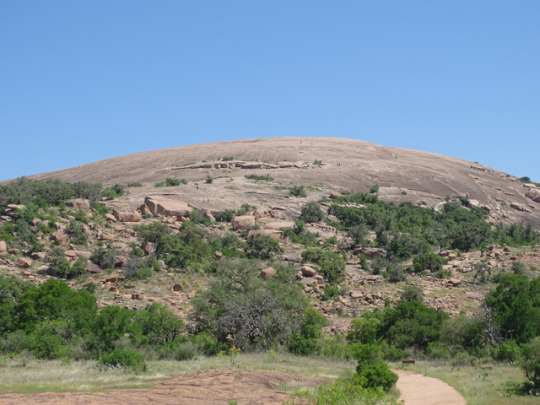
From Earth Science Picture of the Day; June 28, 2018:
Texas Hill Country’s Enchanted Rock
Photographer and Summary Author: Patti Weeks
Enchanted Rock is the second largest pink granite monadnock in the United States. Designated in 1936 as a Recorded Texas Historic Landmark and in 2014 as an International Dark Sky Park, Enchanted Rock State Natural Area occupies a remote section of the Hill Country in central Texas, along with a scattering of cattle ranches, 500 plant species and abundant wildlife
This igneous rock mass, or pluton, located in the Llano Uplift, was pushed up into the overlying sedimentary Cretaceous Edwards limestone from a large magma pool, which was estimated to be 7 mi (11 km) below the surface one billion years ago.
The Enchanted Rock dome is the visible part of a huge batholith, called the Town Mountain Granite. At an elevation of 1,825 ft (556 m) above sea level, the dome rises 425 ft (130 m) above the base elevation. It covers 640 acres (259 hectares), but it's just a small part of the 62 sq mi (161 sq km) underground batholith. Enchanted Rock is an exfoliation dome, with sheets of rock peeling off like layers of an onion. After the overlying sedimentary rock was eroded away, the load on the dome decreased, allowing it to expand and then break into smaller sections and begin sliding down the dome’s sloped sides.
The 15 tiny dots in the top photo are visitors who are hiking the Summit Trail to the top of the dome. The hikers will see the fragile vernal pools, ecologically threatened depressions of flora and fauna, which include rock quillwort and tiny fairy shrimp. Some onion peels and tumbled boulders are visible in the top photo. The photo below shows lower-lying hoodoos that have been eroded through differential weathering of the exposed layers of rocks that have slid or tumbled down the dome. Photos taken May 9, 2018.
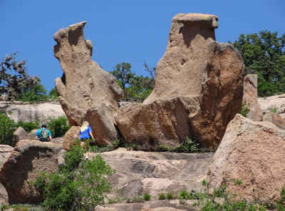
Photo Details: Top - SONY DSC-HX400V camera; 1/800 sec. exposure; ƒ/3.5 aperture; ISO 80; Focal Length: 11.86 mm focal length; 4.3-215mm ƒ/2.8-6.3. Insert - same except: 1/500 sec. exposure; Aperture: ƒ/5 aperture; 53.33 mm focal length.
Enchanted Rock, Texas Coordinates: 30.5066, -98.8189
Related Links
Exfoliation of Half Dome
Liberty Bell Mountain, Washington
Explore Enchanted Rock
Student Links
Igneous rock identification
Earth Observatory
Deep in the Heart of Texas
#earth observatory#nature#landscape#geology#monadnock#pluton#hoodoo#Enchanted Rock#Enchanted Rock State Natural Area#Texas
1 note
·
View note
Last Seen Blogs

jetbougan
jet draws stuff

californiamaids-blog
California Maids San Jose

y-luna
welcome! and good luck :)

blackcardm
Black Card Magician

itsfreespiritposts-blog
In The End We Regret The Choices We Didn't Make.