#grandcoulee
Text
Basalt Castles
surreal landscape inspired a poem and photo capturing the timeless beauty of the basalt castles
#smallpoems #clmooc #poetry24 #poetry
#basalt #grandcoulee #castles #basaltcastles #haiku
Ancient basalt columns millions of years old still stand hundreds of feet tall in a jagged line against the sky in Dry Coulee of Eastern Washington State.
A Little Note
The Photo:
Ancient basalt columns millions of years old still stand hundreds of feet tall in a jagged line against the sky in Dry Coulee of Eastern Washington State.
The Thought:
Most of the basalt columns in eastern…

View On WordPress
0 notes
Photo

On the way to the Grand Coulee Dam, I made a stop to see the grand view of the Dryfalls. [] [] [] #grandcoulee #grandcouleewashington #dryfalls #washingtonscablands #wa #happyhiker #nature #naturephotography #leonorecanyon #precipicetrail #precipice #washingtonstate #centralwashington #lakes (at Sun Lakes-Dry Falls State Park) https://www.instagram.com/p/CPaxpocl4P0/?utm_medium=tumblr
#grandcoulee#grandcouleewashington#dryfalls#washingtonscablands#wa#happyhiker#nature#naturephotography#leonorecanyon#precipicetrail#precipice#washingtonstate#centralwashington#lakes
0 notes
Photo

The lake that the BBQ competition my dad and I went to last weekend.
#bbqcomp#bbqcompetition#easternwashington#washingtonstate#washington#grandcoulee#electriccity#bankslake#bankslake2019#phonephoto#phonephotography#phonephotos#lake#water#pretty#aesthetic
0 notes
Photo

1.12.2019 || #GrandCoulee #Washington #USA (at Grand Coulee Bridge) https://www.instagram.com/p/Bs9q0i6lfjm/?utm_source=ig_tumblr_share&igshid=1e8rvohoaoibo
0 notes
Photo

One of my favorite places. #dryfalls #missoulafloods #grandcoulee #familyvacay (at Dry Falls View Point)
4 notes
·
View notes
Text
Grand Coulee Dam and irrigation...Oh Dam!
Welcome back to another week of Oh Dam!, our mini-series on dams in the Pacific Northwest. Today, we’re discussing the Grand Coulee Dam and irrigation pumping plants and discharge pipes.
The Grand Coulee Dam is part of the larger Columbia Basin Irrigation Project which was commissioned by Congress in 1943 (although “construction of the irrigation system did not start until after World War II”).[1] The Project “is an immense irrigation development in central Washington state that provides water from the Columbia River to about 671,000 acres on the Columbia Plateau.”[2]

Here’s how the system works: “water from Lake Roosevelt behind Grand Coulee Dam is pumped uphill to a 27-mile-long reservoir, Banks Lake, from which it flows by gravity into a series of canals. Outlets for unused water empty into the Columbia above Richland and Pasco more than 125 miles to the south. The project includes more than 300 miles of main canals, 2,000 miles of laterals and 3,500 miles of drains and wasteways. The project provides irrigation water to 2,050 farms. Apples, wheat and corn are the largest-volume crops. There also are large herds of dairy cows and beef cattle. Annually, the cash value of farm production in the Columbia Basin Project is about $630 million.”[3]

Additionally, “O’Sullivan Dam on Crab Creek about 15 miles south of Moses Lake creates Potholes Reservoir, which captures return flows from the northern half of the project. The Potholes Canal flows out of the lake and serves the southern part of the project.”[4] Said in another way, “Potholes Reservoir collects runoff from the north for farms in the south. Water from drains and waste ways returns to the canal system to be reused,” as “irrigation water from the Columbia Basin Project is often used more than once before it returns to the Columbia River near Pasco [Washington].”[5]
“In addition to supplying water for irrigation, producing electricity, controlling floods, providing recreation, and regulating streamflow, the Columbia Basin Project also provides water for cities, industries, navigation, and endangered species.”[6]


[1] https://www.usbr.gov/pn/grandcoulee/cbp/index.html
[2-4] https://www.nwcouncil.org/reports/columbia-river-history/columbiabasinproject
[5-6] https://www.usbr.gov/pn/grandcoulee/cbp/index.html
Photos courtesy of PG 94, (Army Corps of Engineers Dam Construction Photographs, 1933-1965), Special Collections and Archives, University of Idaho Library, Moscow, Idaho.
9 notes
·
View notes
Photo

Thinking back to last Saturday when I documented the wonderful wedding of these two great individuals in #GrandCoulee. What a great day. Going through editing ALL the photos. Can't wait to meet them later this month to deliver their package. #photographer #photography #spokane #canon #portrait #portraitphotography #WeddingPhotography #wedding #bride #groom #like4like #follow4follow #WrightLookPhotography (at Grand Coulee, Washington)
#wedding#bride#photographer#portraitphotography#groom#spokane#grandcoulee#like4like#follow4follow#wrightlookphotography#weddingphotography#portrait#canon#photography
0 notes
Photo

The view of Grand Coulee from Crown Point. #grandcouleedam #grandcoulee #easternwa (at Grand Coulee, Washington)
0 notes
Photo
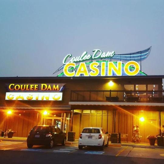
Date night in Grand Coulee means blowing our 💵 at the casino and laser light shows on the dam #AtLeastTheCasinoHadAC #GrandCouleeDam #CampVibes #CampDateNight #LiveLikeLocals #GrandCoulee (at Banks Lake)
0 notes
Text
2016/2/20 – Steamboat Rock IV / 輪船岩之四
2016/2/20 – Steamboat Rock IV / 輪船岩之四
The Rock All photos from this trip can be found here. Once again, the hit-or-miss weather forecast this weekend brought us out east. Apart from the long drive, Steamboat Rock continues to be a favorite fallback destination. All but the first trip were done in late winter, which had proven to be the best and the prettiest time to visit. Not only did we get to spend more time roaming around in much…
View On WordPress
0 notes
Text
A Wish New Year's Eve
A wish of cheer on New Year’s Eve
#smallpoems #clmooc #poetry23 #newyearsevewish
#grandcoulee
Daily Note
Every day, a photograph, a poem. This lovely sunset over the grand coulee, creating a peach tint to the fog below sends a wish of hope and cheer for the new year– that sun shines above on each tomorrow; let that be an evening thought so the tomorrow starts with cheer.
And for tomorrow, you can start the year with a free calendar, something the CLMOOC Collaborative, a group of friends…

View On WordPress
0 notes
Photo


From NASA Earth Observatory Image of the Day; April 19, 2018:
Channeled Scablands
To the non-geologist, the landforms on the Columbia Plateau in eastern Washington might look more like another planet than Earth. Boulders lie strewn across the landscape, amid towering cliffs and plunging holes. Winding channels scar the bedrock. Through the eyes of a geologist, however, the landforms of the so-called Channeled Scablands reveal a past punctuated by violent floods.
The network of channels is visible in a natural-color image (below the map) derived from the Operational Land Imager (OLI) on Landsat 8. The image is a “best-pixel mosaic,” which means it is composed of small parts of many images captured between 2013 and 2018. The technique makes it possible to strip away clouds and haze. The mosaic was then draped over data from NASA’s Shuttle Radar Topography Mission (SRTM) to show the topography.
The channels appear dark brown compared to lighter surrounding areas, but they are not wet. (The water-filled Snake and Columbia Rivers are much darker by comparison.) Instead, these channels take on a dark color because the overlying loess has been eroded, exposing underlying volcanic basalt.
The massive prehistoric floods that eroded this landscape were not always obvious to scientists. Geologist J Harlen Bretz described in 1923 how water could have sculpted the features. “The channeled scablands are the erosive record of large, high-gradient, glacier-born streams,” he wrote in a research paper. He added: “The magnitude of the erosive changes wrought by these glacial streams is nothing short of amazing.” But for decades, his explanation remained controversial.
Scientists have since gained an even better understanding of the events that took place during the last Ice Age 10,000 to 20,000 years ago. As the edge of the Cordilleran ice sheet advanced southward, it formed an ice dam rising about 600 meters (2,000 feet) high along the Clark Fork River. Glacial Lake Missoula grew behind the ice dam and ultimately contained as much water as Lake Erie and Lake Ontario combined. When the dam broke, more than 500 cubic miles of water tore across the region at about 80 miles per hour. The dam grew and broke several times, and the repeated flooding carved out grooves, potholes, and the long channels known as “coulees.”
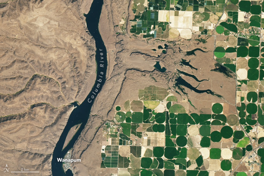
On September 2, 2017, the OLI on Landsat 8 acquired this detailed image of Potholes Coulee. This horseshoe-shaped canyon was formed when floodwaters dropped more than 260 meters (850 feet) in less than 5 kilometers (3 miles) from the Quincy Basin to the Columbia River Valley, stripping away topsoil and eroding the basalt. In modern times, irrigation networks that pull water from the Columbia River have made agriculture productive in places where this rich soil remains.
References and Related Reading
Bretz, J.H. (1923) The Channeled Scablands of the Columbia Plateau. The Journal of Geology 31(8), 617–649.
NASA Earth (2012, February 16) The Legacy of the Megaflood. Accessed April 18, 2018.
National Geographic (2017, March 9) Formed by Megafloods, This Place Fooled Scientists for Decades. Accessed April 18, 2018.
The Pleistocene Post (2011) Potholes Coulee. Accessed April 18, 2018.
The Seven Wonders of Washington State (2015) The Channeled Scablands. Accessed April 18, 2018.
Texas University at Austin (1978, June) The Channeled Scabland. Accessed April 18, 2018.
U.S. Department of the Interior, Bureau of Reclamation, Columbia Basin Project. Accessed April 18, 2018.
NASA Earth Observatory images by Joshua Stevens, using Landsat data from the U.S. Geological Survey and topographic data from the Shuttle Radar Topography Mission (SRTM). Story by Kathryn Hansen. Instrument(s): Space Shuttle - SRTM; Landsat 8 - OLI
#earth observatory#satellite photo#long post#geology#landscape#scablands#Channeled Scablands#Columbia Plateau#Oregon#Washington#space shuttle#landsat 8
17 notes
·
View notes
Photo

The view of the #GrandCoulee from #LakeLenoreCaves! #Highway17 #SoapLake #NorthCentralWashington #NCWpics #ncw http://ift.tt/2s9MRrf
4 notes
·
View notes
Photo

Beautiful #Downtown #CouleeCity, #Washington. #smalltown #rural #community #GrandCoulee #BanksLake #RoadTrip #NWRoadtrips #travel http://ift.tt/2pOFtTt
2 notes
·
View notes
Photo

#BlueLake in the #GrandCoulee! Just north of #LakeLenoreCaves! #boating #fishing #jetskiing #swimming #vacation #getaway #rentals #CouleeCorridor #CouleeCity #Highway17 http://ift.tt/2tQe9nc
0 notes
Photo

Thinking back to last Saturday when I documented the wonderful wedding of these two great individuals in #GrandCoulee. What a great day. Going through editing ALL the photos. Can't wait to meet them later this month to deliver their package. #photographer #photography #spokane #canon #portrait #portraitphotography #WeddingPhotography #wedding #bride #groom #like4like #follow4follow #WrightLookPhotography (at Grand Coulee, Washington)
#groom#portrait#portraitphotography#like4like#wrightlookphotography#photography#wedding#follow4follow#weddingphotography#bride#canon#photographer#grandcoulee#spokane
0 notes
Last Seen Blogs

antiqueland
CHANCE, et malheur

samcurran21
Untitled

watermemorie
from heaven above

nuninaka
nuninaka

kkimhuniver
無標題