#lake eyre flood
Text
Latest Channel Country and Lake Eyre Tours and Flights
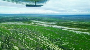
Three cyclones were active over Australia a few weeks ago and this was after a fourth cyclone that occurred earlier this summer. These have had a big impact so here is the News an the Latest Channel Country and Lake Eyre Tours and Flights.
This has brought huge amounts of rain to the Lake Eyre catchment and still there are flood waters moving down and some roads are still closed. Borroloola in…
View On WordPress
#Channel Country Tour#lake eyre flood#Lake Eyre Tours 2024#Latest Channel Country and Lake Eyre Tours and Flights
0 notes
Text
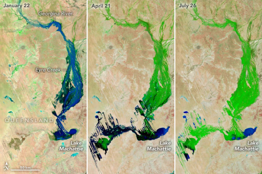
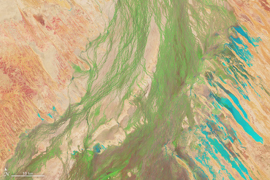
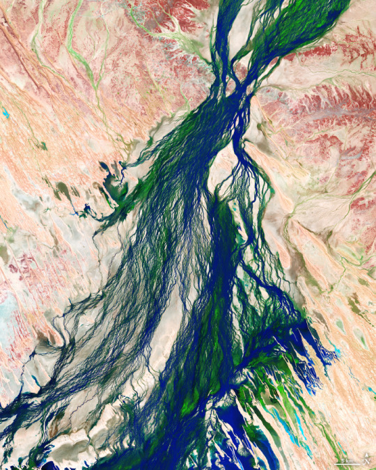
A Series of Inundating Events
One of the wettest wet seasons in northern Australia transformed large areas of the country’s desert landscape over the course of many months in 2023. A string of major rainfall events that dropped 690 millimeters (27 inches) between October 2022 and April 2023 made it the sixth-wettest season on record since 1900–1901.
This series of false-color images illustrates the rainfall’s months-long effects downstream in the Lake Eyre Basin. Water appears in shades of blue, vegetation is green, and bare land is brown. The images were acquired by the Moderate Resolution Imaging Spectroradiometer (MODIS) on NASA’s Terra satellite between January and July 2023.
In the January 22 image (left), water was coursing through seasonally dry channels of the Georgina River and Eyre Creek following weeks of heavy rains in northern Queensland. By April 21 (middle), floodwaters had reached further downstream after another intense period of precipitation in March. This scene shows that water had filled in some of the north-northwest trending ridges that are part of a vast fossil landscape of wind-formed dunes, while vegetation had emerged in wet soil upstream. Then by July 26 (right), the riverbed had filled with even more vegetation.
The Georgina River and Eyre Creek drain approximately 210,000 square kilometers (81,000 square miles), nearly the area of the United Kingdom. Visible in the lower part of the images, the lake gets refreshed about every three years; when it reaches especially high levels, it may take 18 months to 2 years to dry up. Two smaller neighboring lakes flood seasonally. These three lakes and surrounding floodplains support hundreds of thousands of waterbirds and are designated as an Important Bird Area.
Seasonal flooding is a regular occurrence in these desert river systems. However, the events of the 2022-2023 rainy season stood out in several ways. They occurred while La Niña conditions were in place over the tropical Pacific Ocean. (The wettest seasons in northern Australia have all occurred during La Niña years, according to Australia’s Bureau of Meteorology.) In addition, major rains occurring in succession, as was the case with the January and March events, have the overall effect of prolonging floods. That’s because vegetation that grows after the first event slows down the pulse of water that comes through in the next rain event.
The high water has affected both local communities and ecosystems. Floods have inundated cattle farms and isolated towns on temporary islands. At the same time, they are a natural feature of the “boom-and-bust” ecology of Channel Country, providing habitat and nutrients that support biodiversity.
NASA Earth Observatory image by Wanmei Liang, using MODIS data from NASA EOSDIS LANCE and GIBS/Worldview. Story by Lindsey Doermann.
0 notes
Text
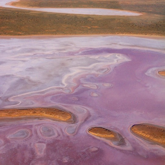
southaustralia
Your eyes aren't deceiving you - this lake is naturally pink 💗
Kati Thanda-Lake Eyre in @flindersrangesandoutback is one of South Australia's famous salt lakes which can change colours when flooded with desert rain 🌧️🌈
Once every few years, networks of channels, streams and floodplains converge in Kati Thanda-Lake Eyre National Park, bringing with them an abundance of wildlife, stunning natural beauty and dreamlike pink and orange hues.
#south australia#australia#kati thanda#lake eyre#natural phenomena#travel#wonder#nature#wildlife#beauty
1 note
·
View note
Photo

What You Need to Know About Rain Broke Records in Australia?
Australia experienced rain broke records in Australia that caused flooding and landslides. Some areas received their highest rainfall in over 50 years. The flooding of kati thanda-lake eyre was another result of the Australian spring flooding in 2022. Read this entire article to learn everything about the record rainfall in australia.
#Rain Broke Records in Australia#Record rainfall in Australia#flooding in Australia#Entegra Signature Structures
0 notes
Link
Satellite derived images showing how Australia’s ‘red centre’, and particularly the Eyre Basin, is transformed by heavy flooding in the first half of 2018.
1 note
·
View note
Photo
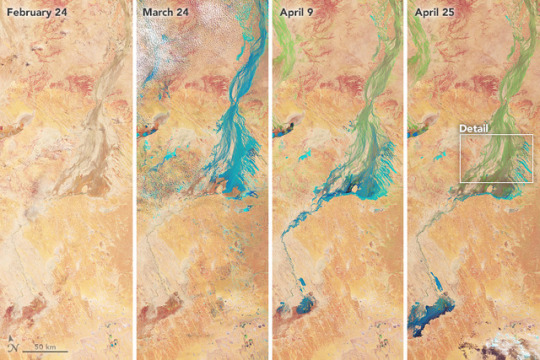
From NASA Earth Observatory Image of the Day; May 4, 2018:
A Pulse of Green in Australia
The Lake Eyre Basin in the interior of Australia is among the driest places on the continent. With less than 125 millimeters (5 inches) of rain falling in this area each year, the streams and creeks that drain into Lake Eyre—the lowest point in Australia—are usually bone dry, barren, and brown.
Occasionally, the channels do fill after heavy downpours—and create a carpet of green. The Operational Land Imager (OLI) on Landsat 8 observed this transformation in a series of false-color images (bands 6-5-3) acquired between February 24 and April 25, 2018. With this band combination, flood water appears light blue. Vegetation is light green.
The Diamantina River flows southwest from northern Queensland toward Lake Eyre in South Australia. In February 2018, its channels were brown and parched. But after a series of storms in March 2018 dumped heavy rain in northern Queensland, water spread across its broad, braided river channels. By April, an expanse of green had emerged in the floodplain after the water receded.
“Ephemeral sedges, reeds, and grasses germinate while the floodplain is inundated,” explained Kenneth Clarke, a University of Adelaide scientist. “The whole life cycle of these species has evolved to take advantage of occasional, short pulses of floodwaters. As the waters recede, the plants finish growing, flower, and set seed—all before the moisture in the soil has been exhausted.”
It is relatively common for the Diamantina River channel and other waterways that connect to Lake Eyre to go green. For instance, a major flood and greening event affected the basin in 2011.
Typically, Lake Eyre fills up about once per decade, though the Diamantina River does deliver small amounts of water roughly every other year. Water from the current pulse of flooding has not yet advanced all the way to Lake Eyre, and there may not be enough water to make it there. Typically, most of the flood water is lost to evaporation and transpiration.
Satellites offer a powerful tool for tracking flooding and greening events, explained Clarke, the co-author of a Goyder Institute report that detailed how vegetation in the basin responds to inundation. “Too often these events are studied at only a few locations and at a few points in time,” he said. “These events can affect huge areas for a long time, but the specific timing, frequency, and duration has not been well studied.”
In addition to providing opportunities for science, greening events offer locals a chance for recreation as well. “Some people make special trips to drive through the region or camp for a while, just to experience the flush of vegetation in the desert and all the wildlife—birds and insects, and some larger animals—that follow,” said Clarke.
Further Reading
ABC News (2018, April 9) After a rainfall, where does all the water go? Accessed May 2, 2018.
Australian Government Lake Eyre Basin. Accessed May 2, 2018.
Bureau of Meteorology (2018, March) Lake Eyre Basin - March 2018 Summary. Accessed May 2, 2018.
Bureau of Meteorology (2010) Lake Eyre Basin. Accessed May 2, 2018.
Goyder Institute (2015) Spatial Indicators of Ecological Condition for Lake Eyre Basin. Accessed May 2, 2018.
NASA Earth Observatory images by Joshua Stevens, using Landsat data from the U.S. Geological Survey. Story by Adam Voiland. Instrument(s): Landsat 8 - OLI
#earth observatory#long post#flooding#environment#ecology#desert#floodplain#vegetation#plants#Diamantina River#Lake Eyre#Australia#landsat 8
1 note
·
View note
Text
April 20 The Oodnadatta Track
Australia is a land full of wonders, with layers and layers of history - a place for discovery. Its forests and gorges are its cathedrals and its precious weathered rock art and ruins, its museums and libraries. Majestic River Red Gums mark the wide river courses which are more often than not dry beds of stones, sand and huge boulders but which, when at flood, cover huge tracts of land. Water! The essential ingredient to the stories of this mostly sunburnt land and which is central to this little story, a story about a small part of our wide brown land, the Oodnadatta Track.
Beneath this iconic outback track lies one of the world’s largest aquifers, the Great Artesian Basin which covers more than 20% of Australia. The Track crosses the traditional lands of three Aboriginal groups - in the south the Kyani people, to the west the Arabana people and to the north the Arrente people. The desert which today we know as the Simpson Desert, has three different names depending on location and is guarded and tended by these traditional groups.
A string of springs runs right through this part of the country, outlets from the deep artesian reserves. Knowledge of the location of these life-giving springs has been passed down by the traditional people of the region for 10s of 1000s of years and they have shared it with explorers and settlers alike warning them that “it isn’t the straightest route but it’s the only one if you are to survive.”
The Track is 600 odd Kms long and we have travelled it a number of times never tiring of its many faces.
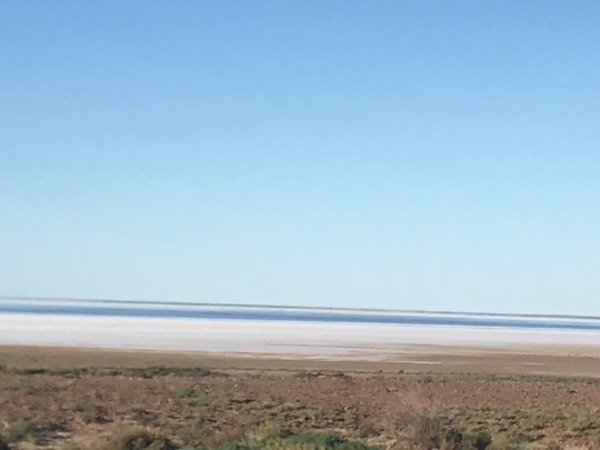
The staggering enormity of Lake Eyre-Kati Thanda which lies to the north of the Track, is mind blowing and the rivers that feed the lake cover a further area of 1.2 million square Kms. Mostly it and Lake Eyre South (pictured above) are dry salt lakes but we have seen water in the southern lake from the Track a number of times. We have even walked to the edge close to the water - or more exactly as close as we could before getting totally bogged almost up to our knees – a little scary actually.
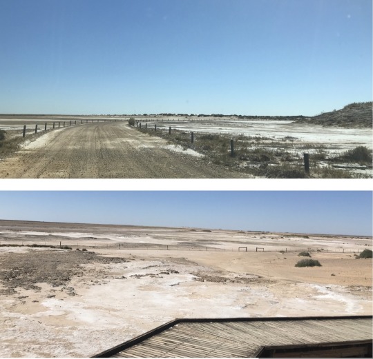
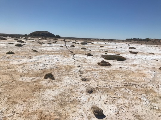
But the springs - we had stayed at and explored Coward Springs but I was keen to explore the mound springs dotted along the track and first on the list were the Wabma Karabu Mound Springs. It was like driving through a moonscape getting to these springs; this is extensive salt pan country.
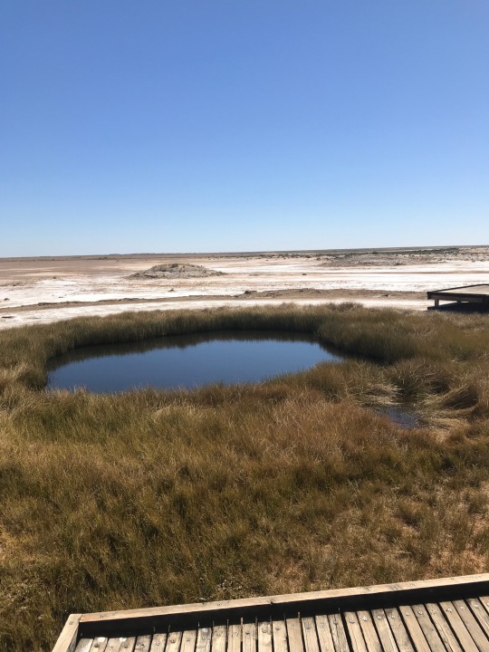
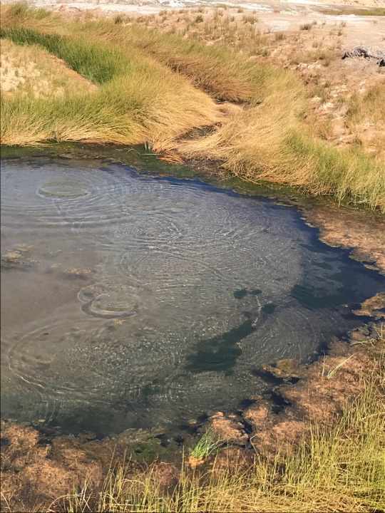
It was rather unbelievable seeing raised water pools in this arid landscape; the first spring is ‘Blanch Cup’. The springs are home to amazing creatures like isopods which seem to be from another world but there are also a few varieties of land snails and fish that live in these pools. The ripples in the second pool are caused by the water bubbling up – this spring is call ‘The Bubbler’. Amazing!
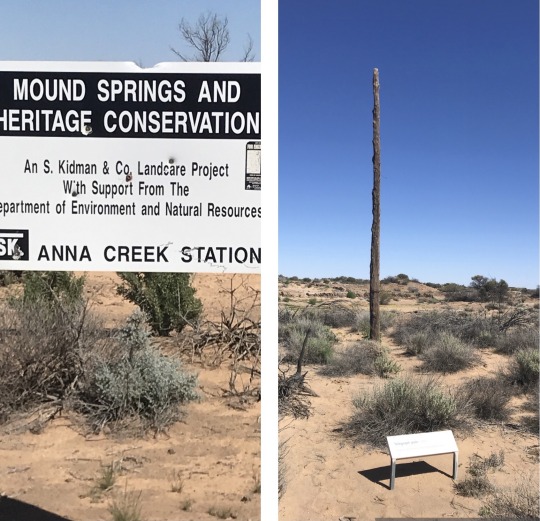
Strangways Springs NW along the Track are within a heritage and conservation area. On the right is one of the last of the original telegraph poles that carried the essential line to Darwin along this line of springs; the pole is supposedly made from native cypress pine which is termite-resistant. Incidentally Anna Creek Station is the world's largest working cattle station.
This is the ‘track’ we followed as we explored Strangway Springs; the stones, we think! Here it was clear but elsewhere it was a bit of a guess. We walked about 6ks and it was pretty ‘warm’.

This is Sedge Spring, one of the mound springs at Strangways. The ledges of this small rocky spring indicate the original depth of the pool and are very fragile. The overflow from the pool creates a trickle of permanent water supporting the sedge community; the sedges are typical of many mound springs. Springs like this in this area are rather precious as many are no longer gurgling due to the number of bores that have been sunk. But they still sustain some precious life out here.
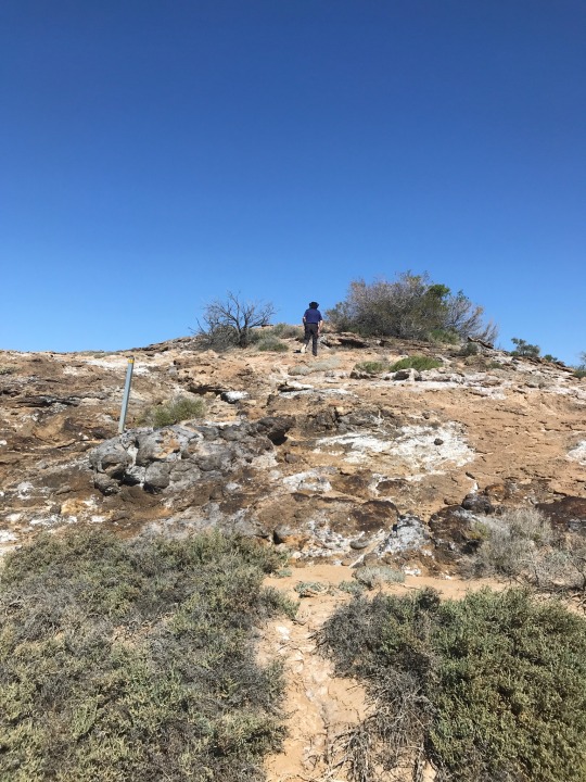
Some of the mound springs were rocky and high and Lindsay just had to climb them to see what was on top. Sadly most were extinct.
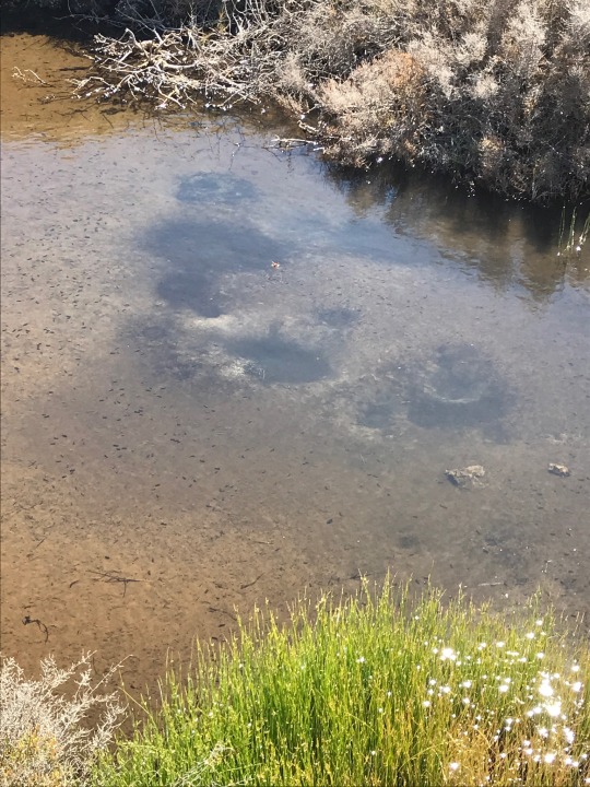
On the bottom of the pool at this spring, you could see little craters of sediment created by the bubbling spring. This spring was fringed with the small sedge, Cyperus laevigatu.
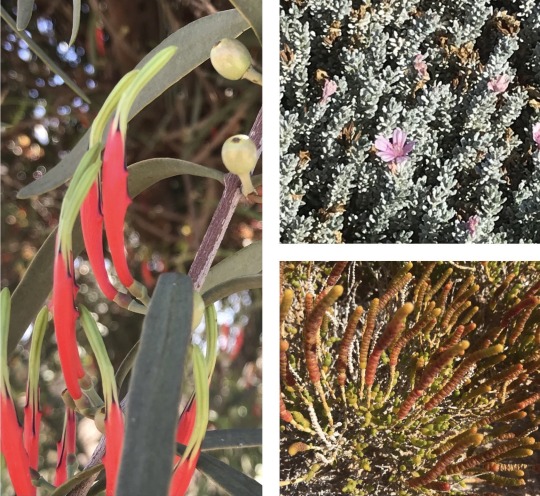
I couldn’t leave this post without sharing a few pix of plants I found – in the most unlikely and seemingly hostile environments flowers bloom. Left is a Harlequin Mistletoe, a bright flash in a parched environment. Top right is Frankenia a small grey-green mounded ground-cover with sweet little pink flowers. It is common near springs and other saline areas. I found it atop one of many extinct springs at Strangways. Lower right is samphire which grow in saline areas inhospitable to many other plants. Small birds eat their fruit.
Wandering the mound springs that day made for a pretty special birthday - starting in Coward Springs and ending at William Creek. More anon …..
#William Creek#Strangways Springs#Wabma Karabu#mound springs#Kati Thanda#Arrente Arabana Kyani#Simpson desert
2 notes
·
View notes
Text
10 Ground-breaking Earth Satellite Images from 2018
In 2018, our satellites captured beautiful imagery from throughout the solar system and beyond. However, some of our favorite visualizations are of this very planet. While this list is by no means exhaustive, it does capture some Earth satellite images from this year that are both visually striking as well as scientifically informative. This list also represents a broad variety of Earth’s features, as well as satellite instrumentation. Take a journey with our eyes in the sky!
10. Hurricane Florence
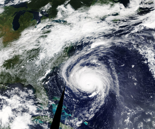
Before making landfall, Hurricane Florence churned in the Atlantic for a full two weeks — making it among the longest-lived cyclones of the 2018 season. When it finally did hit land on Sep. 14, the storm devastated the southeastern U.S. coast with intense winds, torrential rains and severe flooding.
This natural-color image was acquired by MODIS on the Terra Satellite on Sep. 12, 2018.
Images like this, as well as other satellite information, were used to anticipate the impact of the storm. Our Disasters Program created flood proxy maps that were shared with the Federal Emergency Management Agency (FEMA) and the National Guard to estimate how many and which communities would be most affected by the storm, in order to help prepare recovery efforts ahead of time.
9. Australia’s Lake Eyre Basin

The Lake Eyre Basin covers one-sixth of Australia and is one of the world’s largest internally draining river systems. However, the rivers supported by this system are ephemeral, meaning that they only run for short periods of time following unpredictable rain — the rest of the time, the Basin is a dry, arid desert.
However, when the heavy rain comes, the basin erupts in an explosion of green. In this false-color image captured by the Operational Land Imager (OLI) on Landsat 8 on Apr. 25, 2018, you can see how the vegetation completely envelops the spaces where the water has receded. (Flood water is indicated by light blue, and vegetation is indicated by light green.)
Satellites are an excellent tool for tracking greening events that are followed by flooding. These events offer opportunities for predictive tools as well as recreation.
8. Alaska’s Chukchi Sea

A Monet painting comes to life as the Chukchi Sea swirls with microscopic marine algae.
This image was captured off the Alaskan coast by OLI on Landsat 8 on Jun. 18, 2018. After the Arctic sea ice breaks up each spring, the nutrient-rich Bering Sea water mixes with the nutrient-poor Alaskan coastal water. Each type of water brings with it a different type of phytoplankton and the surface waters have just enough light for the algae to populate and flourish. The result is these mesmerizing patterns of turquoise and green.
This image represents one piece of much larger, incredibly complex ecosystem. While one would not normally associate the breaking up of sea ice with phytoplankton blooms, it is an intricate process of the phytoplankton life cycle. The size of the blooms have varied greatly from year to year, and experts are unsure why. Images like these can help scientists track the development of these blooms and link it to other environmental changes.
7. Hawaii’s Kilauea

Sometimes fresh lava is best viewed in infrared.
This false-color image of Kilauea, captured by OLI on Landsat 8 on May 23, 2018, shows the infrared signal emitted by lava flowing toward the sea. The purple areas surrounding the glowing lava are clouds lit from below, indicating that this image was taken through a break in the clouds.
The Puʻu ʻŌʻō Kupaianaha eruption has been continuously spewing red-hot lava since 1983, making it the longest eruption at Kilauea in recorded history. However, new fissures opened up this year that forced many to evacuate the area. Hawaii’s largest lake evaporated in hours and hundreds of homes were destroyed in Vacationland and Kapoho.
Imagery, seismometers and ground-based instruments were used to track the underground movement of magma. Infrared imagery can be incredibly helpful in disasters like this when you to view data that cannot be observed with the naked eye.
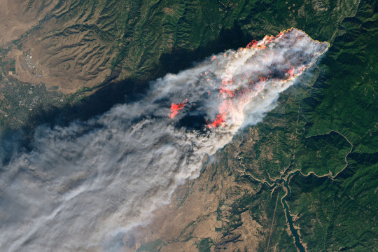
6. California’s Woolsey Burn Scar
Nothing quite encapsulates the destruction of a wildfire like a photo from outer space.
This image of the Woolsey Fire aftermath in Southern California was captured on Nov. 18, 2018 by the Advanced Spaceborned Thermal Emission and Reflection Radiometer (ASTER) on the Terra satellite. This false-color infrared image has been enhanced to clearly show the burned vegetation (indicated by brown) and the vegetation that survived unscathed (indicated by green).
The Woolsey Fire clearly left its mark, with almost 152 square miles (394 square km) and 88% of the Santa Monica Mountains National Recreation Area badly burned. Images like this one can assist fire managers in the area plan for recovery.
5. Bangladesh’s Padma River
As the years go by, the Padma River grows and shrinks, twists and turns. It never has a fixed shape, and as a result, thousands of people must regularly adapt to the constant changes in the river’s 75-mile (130-km) shoreline.
This image captured on Jan. 20, 2018 by OLI on Landsat 8 depicts one of the major rivers of Bangladesh. For thirty years, scientists have been tracking the erosion of the river with satellite imagery. Combinations of shortwave infrared, near infrared, and visible light are used to detect differences year-to-year in width, depth, and shape of the river. Sometimes the river splits off, but then rejoins again later. These patterns are created by the river carrying and depositing sediment, shaping the curves of the path of water.
Monitoring the Padma River is going to become especially important as a new bridge development project advances in the Char Janajat area. Although the bridge will most certainly help shorten travel times for citizens, nobody is quite sure how the river erosion might affect the construction and vice versa.
4. Alaska’s Yakutat Glacier

It’s hard to believe that Harlequin Lake was once all dry land — but it only started to form once Yakutat Glacier started melting. The lake appeared at the beginning of the twentieth century, and has been growing rapidly ever since.
In this hauntingly beautiful image, captured on Sep. 21 2018 by OLI on Landsat 8, the effect of climate change is apparent — especially when compared to earlier images of the region.
Unless the climate warming starts to reverse very soon — which scientists consider very unlikely — Yakutat could be gone as soon as 2070.
3. South Africa’s Theewaterskloof

Cape Town is a seaside city planted on the tip of South Africa. It’s a city known for its beaches and biodiversity — it also almost became known as the first major city to officially run out of water.
This image of Cape Town’s largest reservoir — Theewaterskloof — was acquired on Jul. 9th, 2018 by OLI on Landsat 8. By the time this photo was taken, the city’s main reservoirs stood at 55%. This was a huge increase from where it stood just six months earlier: just 13%.
The severe water shortage in the region started in 2015, only to become more threatening after three successive and unusually dry years. The entire city was preparing for Day Zero — the day the tap water would be shut off.
Despite forecasts that Day Zero would arrive in April, a combination of heavier rains and local conservation efforts restored the majority of the reservoir.
2. Aerosol Earth

Aerosols are all around us. From the smoke from a fire, to the dust in the wind to the salt in sea spray — these solid particles and liquid droplets are always swirling in our atmosphere, oftentimes unseen.
The Goddard Earth Observing System Forward Processing (GEOS FP) model uses mathematical equations to model what is happening in our atmosphere. The inputs for its equations — temperature, moisture, wind, etc. — come from our satellites and ground sensors.
This visualization was compiled on Aug. 24, 2018 — obviously a busy day for aerosols in our atmosphere. Swirls of sea salt (indicated by blue) reveal typhoons Soulik and Cimaron heading straight towards South Korea and Japan. A haze of black carbon (indicated by red) suffuse from agricultural burning in Africa and large wildfires in North America. And clouds of dust (indicated by purple) float off the Sahara desert.
1. Camp Fire
With nearly a hundred fatalities, hundreds of thousands of acres burned and billions of dollars of damage, the world watched in horror as Camp Fire grew to become the most destructive California wildfire in recorded history.
This image was captured on Nov. 8, 2018 by OLI on Landsat 8 on the same day Camp Fire ignited. It consolidates both visible light and shortwave-infrared light in order to highlight the active fire. Strong winds and dry conditions literally fanned the flames and spread this wildfire like a rash.
This image has not only become the iconic portrait for Camp Fire, it is also sobering representation of how quickly a fire can grow out of control in a short amount of time. Even from space, you can almost smell the massive plumes of smoke and feel the heat of the fires.
Whether you realize it or not, our Earth satellite missions are collecting data everyday in order to monitor environmental changes and prepare for natural disasters. If your interest is piqued by this list, head over to the Earth Observatory. The Earth Observatory updates daily with fresh, new content — brought to you by none other than our eyes in the sky.
Make sure to follow us on Tumblr for your regular dose of space: http://nasa.tumblr.com
#NASA#Earth#satellite images#space#earth science#Earth satellite#natural disaster#wildfires#aerosols#glacier#river#erosion#volcano#hurricane#infrared#sea#sky#satellite#lake#storm#geography#smoke#camp fire#florence#hurricane florence
7K notes
·
View notes
Text
Aussie stuff that’s a must
If you ever visit Australia here’s a to do list for you (some things you can do at home, like the music and movies, look up some of the food recipes or something):
To Eat:
Bunnings sausage sizzle
Anzac Biscuits
Macadamia nuts
Damper
Chicken parma
Chiko Roll
Vegemite
Kangaroo
Barramundi
Chineses takeaway
Meat Pie
Milo
Vanilla Slice
Chocolate Milk (Oak or Moove)
Goon
Fairy Bread
Lamingtons
Pavlova
Golden Gaytime
Tim Tams
Fantales
Iced Vovos
Milo
Shapes
Cherry Ripe
Twisties
Redskins
Passiona
Bubble O’Bill
Chicken Salt (on chips)
Solo
Caromello Koala
Scotch fingers
Cheezels
Mint Slice
To Do:
Goon of fortune
Join a game of beach cricket
Boogie Board
Slide down a sand dune
Bird watching
Bush walking
Climb Sydney Harbour Bridge (or for a cheaper experience just walk across it)
Go to the beach
Farmers Markets
Gold Coast theme parks
Swim with a croc or sharks
Skiiing
Watch baby Sea Turtles hatch
Phillip Island tour (see the Little Penguins!)
Visit a wildlife Sanctuary
Have a BBQ
See a cricket match
Visit a small country town. (like populations under 100)
Meet some Aboriginals (Arnhem Land is a great place)
Play tug-o-war with a Tassie Devil (some zoos/sanctuaries do this)
To See:
Great Barrier Reef
Uluru
Sydney Opera House (and Harbour Bridge)
Bondi Beach
Rottnest Island ( the Quokkas!)
Lake Eyre during a flood
Kangaroo Island
Fraser Island
The Graffiti in Melbourne
Devils Marbles
The stromatolites
Wave rock
The Nullarbor Plain
Cradle Mountain
Vivid Sydney
Darwin Beer Can Regatta
Mardi Gra in Sydney
Lake Hillier
Coober Pedy
Wolfe Creek Crater
The Pinnacles
The Bungle Bungles
Burning Mountain
Marree Man
The big stuff (like the Big Banana, the Big Pineapple, the Giant Koala and so on)
Dubbo Gaol
The Dingo Fence/ Rabbit Proof Fence
To listen to:
Anything by Acca Dacca (AC/DC)
Down under -- Men at Work
Anything by John Farnham
Prisoner Of Society – The Living End
Great Southern Land – Icehouse
Anything by Cold Chisel
Anything by Jimmy Barnes
Eagle Rock – Daddy Cool
The Horses – Daryl Braithwaite
Boys In Town – Divinyls
Anything by Midnight Oil
Errol – Australian Crawl
Anything by Silverchair
One Crowded Hour – Augie March
Throw Your Arms Around Me – Hunters & Collectors
Sounds of then - Gang Gajang
Solid Rock - Goanna
I am Australian - The Seekers
A Pub With No Beer - Slim Dusty
Island Home - Christine Anu
Am I Ever Going to See Your Face Again - The Angels
Love is in the Air - John Paul Young
I Touch Myself - Divinyls
Heaven (Must be There) - Eurogliders
The Nips Are Getting Bigger - Mental As Anything
Anything by Killing Heidi
And of course, anything by The Wiggles
To Watch:
Priscilla Queen of the Dessert (comedy-drama classic)
The Dish (comedy cased on a true story)
Rabbit Proof Fence (drama based on a true story)
Kenny (mockumentary, comedy)
The Dressmaker (revenge comedy-drama)
Crocodile Dundee (but pretty sure this is very famous overseas)
Wolf Creek (horror)
Moulin Rouge! (musical romance)
The Sapphires (comedy-drama based on a true story)
Mad Max (action)
The Little Death (comedy)
Gallipoli (war drama)
Strictly Ballroom (rom-com)
Looking for Alibrandi (Drama-romance)
Red Dog (comedy-drama based on a true story)
The Castle (comedy-drama classic)
The Man from Snowy River (drama)
Phar Lap (about the race horse)
Burke and Wills (adventure based on a true story)
The LIghthorsemen (War based on a true story)
Muriel’s Wedding (comedy-drama)
Babe (family movie)
Romeo and Juliet (drama-romance)
Blackrock (drama-thriller)
The Man Who Sued God (comedy-drama)
Cracker Jack (comedy-drama)
Happy Feet (family movie)
Kokoda (drama-war based on ture stories)
Australia (romance-historical)
Bran Nue Dae (musical comedy darma)
Let me know if there’s anything you think I’ve left out!
#Australia Bucket list#Australia#Australia to do list#Aussie foods#Aussie music#Aussie things to see#Aussie movies
28 notes
·
View notes
Text
Tehran to Kashan
Tehran to Kashan
Today we drove about 250 km south to Kashan. The drivers on the highway were as chaotic as in Tehran and we all were amazed at the chopping and changing of lanes etc.
Along the way we passed the largest salt lake in Iran which is full of water at present due to the recent flooding rains ( sounds like a lake Eyre) and some fabulous mountain scenery.
Our first stop in Kashan was Fin Garden which is a UNESCO site,A feature of Persian Gardens is a water feature and this garden has water channeled down from the mountain into long narrow pools with little fountain Sparta. There is also a lovely portico with stunning tiles and paintings. The garden with its lovely floral displays is quite amazing as the surrounding countryside is desert.
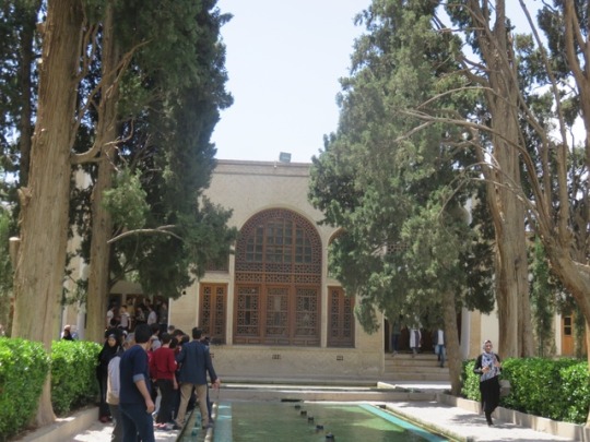
As it was Thursday , the first day of an Iranian weekend there was a large number of people particularly families .Iranians are perhaps the friendliest people I have ever met. At the gardens and throughout the rest of the day , we were continually being greeted with “ Hello”, “Welcome” or “ Thank you for coming” or all three . People wanted to take our photo or have photos taken with us.
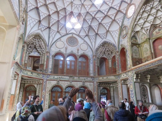
Kashan has many lovely old homes which were owned by rich merchants, Many if these have been converted into restaurants and we had lunch at one of these, Abassian House. Again a great meal.
After lunch we visited two of the old merchant houses which were owned by a carper merchant , Borojeurdi House and one,Tatatabel House by his his father in law , another carpet merchant. Both had lovely garden courtyards and one could imagine how magnificent they would have been in their heyday.
We then checked into our hotel which is one of the many merchant houses which have been converted into boutique hotels. Our hotel The Abdi is is delightful.
After a very quick refresh , we were off to walk through the historic bazaar which Rosemary ( who it could be said intensely dislikes bazaars) admitted was not too bad. I think Malid our guide teaching many how to take a vertical panorama shot on their phone won the highlight of the trip to the Bazaar.
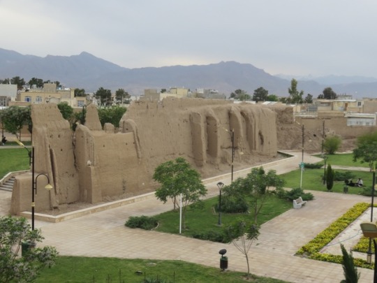
Then a visit to the ramparts of the old city walls for a spectacular view before heading to the home old Layla and Mohammed for a spectacular dinner with them and their family. Lots of food, chatter and photos.
A lovely day in Kashan.

2 notes
·
View notes
Text
Lake Eyre Tours in 2024
Embarking on Lake Eyre Tours in 2024 with Spirit Safari in the heart of Australia is a journey unlike any other, especially in the wake of cyclone Kirrily creating huge 2024 floods. Tours are available as 3, 4, 6, 8 or 10 days.
This rare phenomenon has transformed the desert landscape into an oasis, creating a spectacle that captures the essence of nature’s unpredictable beauty.
Our Lake Eyre…
View On WordPress
#4wd tours#Lake Eyre flights 2024#lake eyre flood#lake eyre tours flights 2024#Lake Eyre Tours in 2024
0 notes
Photo

Seasonal Flooding of the Diamantina River The Diamantina River in Australia runs southwest from northern Queensland toward Lake Eyre (Kati Thanda) in South Australia—the lowest point on the continent. It is one of several rivers in the Lake Eyre Basin, which is situated in Australia’s desert interior and drains approximately 15 percent of the continent. For much of the year, its beds remain dry. However, seasonal rainfall sends water coursing through its channels and transforms the otherwise parched landscape. These false-color images illuminate the results of this phenomenon. The Operational Land Imager (OLI) on Landsat 8 captured the images on April 7, 2023, as floodwaters from rainfall in February and early March flowed through the Diamantina River catchment. The images combine the shortwave infrared, near infrared, and red light (OLI bands 7-5-4). In this configuration, bare earth appears brown or reddish, vegetation is green, and sediment-laden water and saturated soil are shades of blue. Bursts of vegetation growth that tend to follow in the wake of the floodwaters appear to be cropping up. A similar pulse of green is visible in images acquired in 2018. The wide view (top) shows a textbook example of an anabranching river, according to Sara Polanco, an expert in landscape dynamics and a lecturer at The University of Sydney. In contrast to the channels of braided rivers, which shift around within the riverbed, the many channels in anabranching rivers are hemmed in by semi-permanent islands stabilized by vegetation. A detailed look at the lower-right portion of the wide view reveals other notable features. Here, some of the floodwaters divert into north-northwest trending ridges that are part of a fossil landscape of wind-formed dunes. As water flows through the troughs, it forms several small delta-like features, which some researchers refer to as floodouts. “They are ubiquitous in Australia,” said Polanco. “Sometimes it looks like the river channels just disappear, but when these systems are in flood, the connection between the channels and the surrounding landscape is finally revealed.” About every eight years, rivers in the basin reach Lake Eyre. The Diamantina River has historically provided 75 percent of the lake’s water. Floodwaters have yet to flow that far this year, and it’s uncertain if there will be enough water to reach the lake. Most is lost to evaporation and transpiration along the way. Recent observations and the three-month streamflow forecast, from Australia’s Bureau of Meteorology, show levels near or slightly above the median, relative to historical records. On May 1, 2023, the bureau still had a minor flood warning in place for the town of Birdsville, about 130 kilometers (80 miles) downstream of these images. However, the report noted that flooding is easing and the river should soon dip below the minor flood level. NASA Earth Observatory images by Allison Nussbaum, using Landsat data from the U.S. Geological Survey. Story by Lindsey Doermann.
0 notes
Text
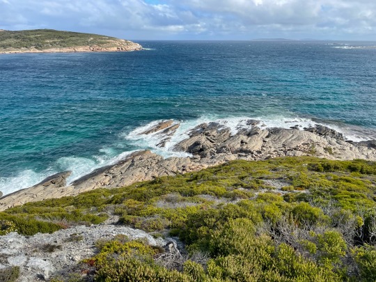
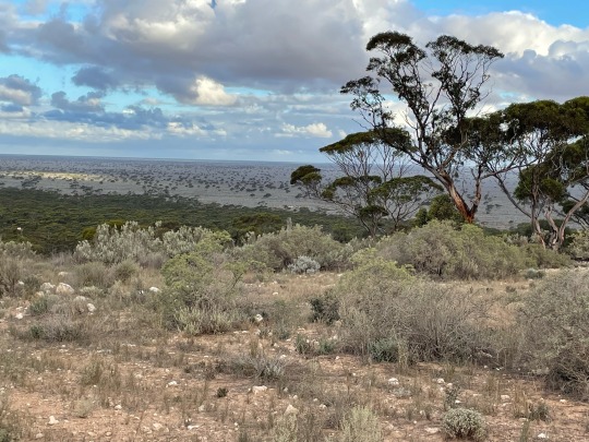
And so our 12 months in beautiful Perth is drawing to a close 😢 Besides escaping the COVID lockdowns in Sydney and the rain and flooding that has beset Sydney and the east coast, we’ve loved reconnecting with family, making new friends, discovering some amazing places and living in Subiaco this past year. Our car is being loaded up, one more family get together tomorrow and then come Monday morning, we start our adventure back across this vast country, this time heading to near Rosebud, Victoria for the next 12 months to finally become a real, live grandma to Angus( and not just on a screen) and spending time with Claire & Daniel and Phil & Joey in Victoria. First stop will be Esperance.
We left Subiaco early this morning and like our first day travelling over here, returning back east, the day has been cold, windy, overcast and rainy. We were disappointed as we were hoping to go swimming in the beautiful beaches here
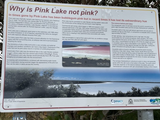
Also discovered that the Pink Lake hasn’t been pink since 2007 😩
Oh yes, the pie scorings have recommended. Today’s was a 7 for a steak and mushroom pie at Esperance
Looking forward to a good sleep tonight and Day 2 tomorrow.
Wednesday
Driving back through familiar territory
Tuesday
Nearly to the WA border today- made it as far as Madura. Nothing much to report, not even a pie score. Paid $2.60/L for petrol
The only photo taken today was of Madura Pass- the only large Rocky outcrop we’ve seen all day
Wednesday
Travelling through familiar territory today with our destination Ceduna, SA, where we’ve just arrived.
Nothing much to report today guys. xx
Thursday
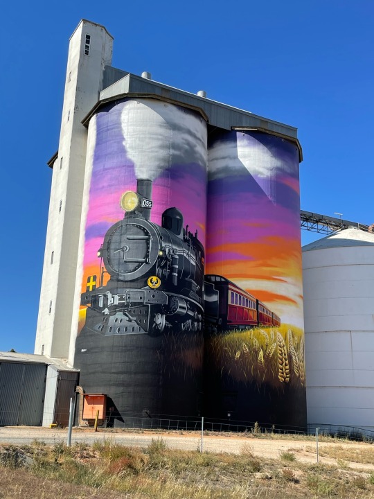
Left Ceduna and headed for Port Pirie. First day of no rain.
Stopped at Kimba on the Eyre Highway which is the half-way mark from West to East coast and home to this beautifully painted silo
Saw lots of these from just outside of Port Augusta
Friday
Decided to visit the historic copper mining town of Burra on our way to Clare Valley.
Passed the house that featured on Midnight Oil’s record Diesel and Dust. Also has been photographed by Ken Duncan
Also visited Seven Hill winery and explored the church and cellars before heading to the historic Martindale Hall.
Oh, some more Silo art- this time at Farrell Flat
Saturday
A loooong day of driving (at least for Peter) to Port Fairy
Saw some more silo art at Owen and Coonalpyn and some gorgeous rolling hills, cattle, sheep and a lot of pine forests! Next stop is Rosebud tomorrow and my first Angus cuddle in over 13 months😍
Sunday
Finally arrived at our destination

1 note
·
View note
Text
4 POEMS by Jake Sheff
Elegy for Dog I: A Failed Acrostic
January was tired when it became king.
Apples here love being red in the spring,
Casting shadows against the stone architraves our
Kapellmeister will never live down. You
Stole Apollo’s cows, and let them graze to show me
Heaven’s template. Where do failed heroes go?
Eucalyptus cupolas and polar icecaps
Frame the downtrodden gods. But you weren’t
Freakishly wrong, as I so often am, on your
Joyride through nearly twice eight years,
Á la someone far from beauty’s stepmom.
Copper coin or grimacing sun? I’ve got 20,000
Kor of crushed grief on this threshing floor.
Shark-sparks of sadness flood the impetiginous air…
How, and why, do clouds cobblestone
Entire days, and lakes, when you’re not here?
Fixing every broken thing, poets go where
Ferns and geraniums baptize the morning.
“Jur-any-oms,” is how you’d spell it;
After all, a dog’s a dog, and wisdom knows futility.
Cassations make a rusty brew, to drink the truth of truths, and
Kill whatever ceases wanting to be new.
Stewardship, the color of gravity’s silence, naturally
Houses every “glur” (a glittery blur); go chase what plays
Eternal games. I hear the swans by Rooster Rock. Your handsome
Face, its happy handsomeness, in memory’s eye, goes in and out of
Focus; in love’s better eye: your goodness neath its everblooming ficus.
Gravity and Grace on SW Murray Scholls Drive
“Impatience has ruined many excellent men who, rejecting the slow, sure way, court destruction by rising too quickly.” Tacitus, The Annals of Imperial Rome
The traffic lights control the people’s actions, but
Not their feelings, as the limits of philosophy
Collide head on with the nose of a Dalmatian.
I tell you, the day is stress-testing itself, and these
Sidewalks wish that it’d just gone straight. Geese
Take this sky-hairing wind for granted, as they
Land on the lake like memorable speech on
The sensitive soul. Time is never sharp, but it’s
Cutting something in the credit union. Maybe
It’s dancing a back Corte for the woman in line
Thinking about the taste of limes from Temecula
As she waits for the teller. Air Alaska and that
Haunted pie in the sky are not the only reasons
For all the volatility in the air today. Rushing
And perfectionism both produce a loss; behind
The Safeway Pharmacy, you’ll see the small
Smells of both, sloshing around to the ticking-
Sound of the ocean’s tides. I must admit, I am
Frozen in place by the sight of steam from Joe’s
Burgers; it is poetry’s pale tongue, rising in
And arousing the air. This neighborhood’s street-
Lights are more serious than kokeshi dolls. Lights
From its windows outshine poison dart frogs.
Maybe to forget about life for awhile, the lamps
Are focused on The Population Bomb? ‘Easy
Tiger,’ all these incidents whisper. Each day’s
A sign twirler’s dais; each corner a promise
Of something more in a different direction: it isn’t
A marriageable daughter or impoverishment,
But inguinal ingenuity plays a part, and that isn’t
Bad at all. What oaths and paths went here
Before Walmart? What voices were voided by
The liquor store? What are vague’s values
When the library shares a parking lot with a 24-
Hour gym and a cargo cult? Gas stations satirize The Queen of Hearts; I tell you, it makes every
Question seem incidental. Treaty-breakers in
Pajamas swing on the swing sets. Was August
That full of angst? It feels like autumn went too
Far on accident. Desertification, in a sugar tong
Splint, takes a shot of ouzo and talks shit
About the death of Brutus, but my Bible-thumping
Memory – on a ski hill in Duluth – is also too busy
Watching some ducks on the lake to notice; and
Desertification makes a face at me like a Swedish
Film. Poets make for poorly picked men to
Familiarity’s paymaster-general. The Calvinistic
Rain is an ill-starred attempt to make mayonnaise-
Fries just for me, but I must admit, it all seems –
You know – cybernetic. And step-motherly as all
Get out, if you ask the trees. They prefer “You
Can’t Hurry Love,” by The Supremes, to any
Changes that take effect in one to two pay periods.
Pretext ricochets; a perfect reverse promenade.
At Summer Lake, When the Vegetables are Sleeping
Cruelty drinks all the wine, and never gets drunk
On these shores. When Summer Lake speaks,
In every word, an introduction to the world. I am
Easily duped. The greatest duper duplicates my pride,
Which always lingers, in the hallways of my heart
And beneath the surface of Summer Lake. The sky is
Supplicating, it’s literally shaking. An hour passes
Faster here, the hour always held too dearly dear
In paranoid and ivied walls. The ducks can do
An unwise thing correctly, and it sounds more like
Dusty than Buffalo Springfield to the enokitake
Sold in Springfield, Illinois, which is the opposite
Effect it has on the wild mushrooms on these shores.
On cables capable of love, the geese convince
The weather to taste like kvass today. Basically,
Another Cuban Missile Crisis drowned itself just
Now. The clouds might ask themselves, ‘Is lowliness
Allowed here?’ To which the crows might ask,
‘Does omertà sound like lightning?’ The answer’s
Oubliette is ten times worse than impotence.
Summer Lake isn’t smart, but it stays quiet, like
Someone too smart to say all they know. ‘Whoa,
Sweet potato,’ the capital gains tax mutters
To itself, knowing that what matters doesn’t mean
A thing. Some say the lake bottom’s sands receive
Commands from Hearst Castle, others say
Its hands are King City’s hands, and still others
Maintain more sins have been than grains of sand
Times secondary gains, and that explains
The beauty and industry that none can see but
All can feel on these shores. (Some possibilities
Play possum, or get opsonized by hate; this one snores
Like Rip Van Winkle.) This orb-weaver spider is
The Milton Friedman of Summer Lake, the wind
On her web is Grenache from The Rocks District
Of Milton-Freewater AVA for the eyes. The day is
Stereotypical, although it feels like three days
In one…But for the lake’s good counterfactual
Questions, I would forget that some die young,
But most die wrong. I’ve tried to pick up Summer
Lake’s reflections in three lines or less, but
The hardest truth is your own impotence. Oh,
It’s hard to hand your power over to a thing
No one can see. Hopped up on distinctions – not
The obvious distinctions – Summer Lake is pretty;
Cold, but pretty! In the distance, with so many
Intercessory prayers, hot air balloons are rising;
Shaped like teardrops, upside down and rising.
This lake re-something-or-anothered me. Are first
Impressions wrong sometimes? I am a season’s
Golden calf, according to the sunlight, doing
A prospector’s jig on the surface of Summer Lake.
If not for the Weimar Republic’s wooden-
Headedness, I’d set down my heart-song and
Listen to reason on these shores. I never trust
An activist guitar, if the weather is socially clumsy.
The future is reflected on the lake: it always
Laughs at us – between its math and gratitude
Lessons – and never thinks of (or gives thanks to)
Us enough. The presence in the lake juniors
My ears. The day is not too baffling, nor is it
Jane Eyre. Space-themed and spiritual, some autumn
Leaves are swimming in the rain. The ducks arrest
My attention in the mardy weather, even though they
Must know my attention is dying. The barbed wire
Around my stated goal is an outcome out of
Their control. Picnickers picnic with acorns and apricots,
On blankets covering Holy Schnikey’s death mask.
My unsandaled thoughts thrive and increase on these,
And no other shores. They are pets for the days less
Important than love, when Summer Lake says it’s
Humble, because it knows the right thing to say.
Summer Lake gives the comfort of commonly held
And seriously absurd beliefs to the blue heron.
Nothing is wrong with this lake or anything in it,
Not even the ghost of Amerigo Vespucci. It’s all so
Simple to the stiff-necked molecules of water, made out
Of frogs and snails and puppy-dog’s tails. These thoughts
Are fine manna in a fine ditch. Post-structuralist squirrels
Can tell my heart’s in Italy, and I’m in the intellectual
Laity. Chivalry’s technician sees my shovel, and they say,
‘You’ve got to hand it to him.’ Neurocysticercosis
Sets the bar high; it looks at this park, and thinks
The smartest monkey drew the perfect landscape.
That’s this maple tree’s previous disease, its precious
One. It unfurls the ferns of my firm and foremost
Beliefs, I’m told, to partialize insufferable vastidity.
We Install a Sump Pump on (What Used To Be) a Holiday (Take 2)
The oppressive heat was born a fully grown
Man. I admire the result of its effort, but
Despise the means of achieving it. My wife
Asserts her individuality in the gunk; her
Body’s allegations aren’t too soft or hard today.
Her self-interest seems to have drowned in the vortex.
Our little garden knows flippancy with regards
To privacy is unwise. The stepping stones can
Only blather, as slugs draw nomograms on
Their faces. My wife’s body speaks Proto-Indo-
European in the vortex and denim overalls.
Marc Chagall’s The Poet studies her. He calls her
‘Innocence: The opposite of life! A criminal with
A badge!’ I hand her the tools of a crude and
Rudimentary faith, and she says, ‘Jill, great books
Make fine shackles.’ Her arms only have
An administrative objective in the vortex, but
They are where good things come from.
Jake Sheff is a pediatrician in Oregon and veteran of the US Air Force. He's married with a daughter and whole lot of pets. Poems of Jake’s are in Radius, The Ekphrastic Review, Crab Orchard Review, The Cossack Review and elsewhere. He won 1st place in the 2017 SFPA speculative poetry contest and a Laureate's Choice prize in the 2019 Maria W. Faust Sonnet Contest. Past poems and short stories have been nominated for the Best of the Net Anthology and the Pushcart Prize. His chapbook is “Looting Versailles” (Alabaster Leaves Publishing).
1 note
·
View note
Photo
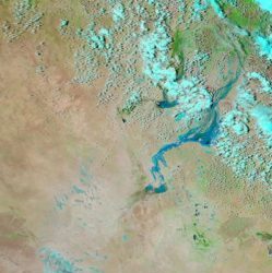
From NASA Earth Observatory Image of the Day; February 27, 2017:
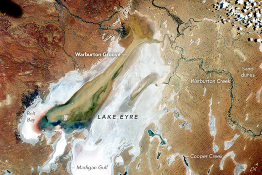
Flood Waters Reach Kati Thanda–Lake Eyre
Taken by the EarthKAM camera on the International Space Station, this photograph shows Australia’s largest inland lake. Lake Eyre is easily recognizable from space, being a large, white-floored lake bed that is usually dry. However, a remarkable, periodic change was visible in February 2017.
Tan, green, and blue splotches stretching across the lake bed are the result of flood waters channeled down Warburton Groove. The Warburton Creek enters Lake Eyre at its northern end, and is seen here flooding into the dry lake. The event gave rise to a variety of colors indicating new vegetation, algae-tinted water, and muds transported by the flood water. A smaller discolored zone appears where the southern arm of the Warburton delta has also spilled water onto the lake floor (image center).
In this desert region, flood waters rarely reach the lake, instead evaporating along the way or getting absorbed by dune sand. But after heavy rains fell in late 2016, floods in rivers like the Warburton and Cooper have managed to reach Lake Eyre after a delay of months as the water slowly rolled across the vast watershed. As of February 20, 2017, water was reported to be flowing down the entire length of the lake (130 kilometers, or 80 miles), and reaching one of the lowest points (15 meters or 50 feet below sea level) at Belt Bay, where the water depth was measured at 1.3 meters (4 feet).
The lake is now formally known as Kati Thanda–Lake Eyre. Australia is one of many countries that have adopted a dual-naming policy for some natural features and cities.
Click here for a view of lake as it appeared from the space shuttle in December 1990.
EarthKAM photograph CCFID_126465_2017038014745 was acquired on February 14, 2017, with a Nikon D2Xs digital camera using a 50 mm lens, and is provided by Sally Ride EarthKAM@Space Camp on the International Space Station. The caption is provided by the Earth Science and Remote Sensing Unit, NASA Johnson Space Center. EarthKAM (Earth Knowledge Acquired by Middle school students) is a NASA educational outreach program that enables students, teachers, and the public to learn about Earth from the unique perspective of space. During Sally Ride EarthKAM missions, middle school students around the world request images of specific locations on Earth. The image in this article has been enhanced to improve contrast. Caption by M. Justin Wilkinson, Texas State University, Jacobs Contract at NASA-JSC. Instrument(s): ISS - Digital Camera
#earth observatory#international space station#lakes#Lake Eyre#Kati Thanda–Lake Eyre#flooding#Kati Thanda#South Australia#Australia#long post
2 notes
·
View notes
Last Seen Blogs

f-rnand0
Abdl Daddy, 23 years old

sorrymasen8-blog
80s-empire • empire-2000

6v6taeminisloveshineeworld
6v6 Taemin Is Love SHINee World

mataobeat
Untitled
