#natural sandstone Central West
Video

flickr
Now Is the Time to Explore by Mark Stevens
Via Flickr:
At a roadside pulloff along the Boynton Pass Road with a view looking to the southeast and to rear using a side mirror with mesa and butte cliff face off in the distance.
#Along Roadside#Arizona Petrified Forest National Park and Sedona#Azimuth 134#Blue Skies#Boynton Pass Road#Central Arizona Highlands#Coconino National Forest#Colorado Plateau#Day 5#DxO PhotoLab 4 Edited#Flagstaff Area#Forest#Forest Landscape#Hillside of Trees#Intermountain West#Landscape#Landscape - Scenery#Looking SE#Nature#Nikon D850#No People#Off Side of Road#Outside#Pinnacles#Project365#Road#Roadside Pulloff#Rock Spires#Rolling Hillsides#Sandstone Mountains
0 notes
Text
The Golden Citadel: Exploring the Enchanting Jaisalmer Fort
Because of the golden-colored sandstone that was utilized in its construction, the Jaisalmer Fort is often referred to as "Sonar Qila" or the Golden Fort Jaisalmer. With our Rajasthan vacation packages, you may catch a glimpse of the fort's glistening golden glow at dawn or dusk.
The historical significance and the architectural brilliance of this fort have earned the recognition of being a UNESCO World Heritage Site. What truly sets this fort apart is the astonishing fact of Rajasthan is that it is the only living fort in India.
Perched on top of the Trikuta Hills, Rawal Jaisal constructed the Jaisalmer Fort in 1156 AD. It is a magnificent example of Rajasthani architecture with elaborate carvings and latticed stone work known as "jaali." It is encircled by a 30-foot high wall with 99 Bastions.

Jaisalmer Fort History
Legend has it that Rawal Jaisal received advice from Lord Krishna to strategically locate this fort atop Trikuta Hill, which was chosen for this purpose because of its natural elevation. The advantage of this was getting a vantage point to observe the enemy movements from far away and also better protection from potential invaders. Hence, the Jaisalmer Fort was founded in the year 1156 AD, which is one of the Historic Forts to Visit in Rajasthan.
The fort's location was strategically significant since it was along the old trade routes that connected Egypt, Central Asia, and India. Because of its location, trade was very successful in this area, especially throughout the Middle Ages.
The wars of 1536 against the Sultan of Gujrat, 1541 against Sher Shah Suri, 1556 against Emperor Akbar, and 1762 against the Maratha empire were among the other conflicts fought here.
The region experienced a flourishing of art, architecture, and culture under the magnificent reign of the Jaisalmer Fort. The fort developed become a hub for cultural events, inspiring the building of spectacular.
Things to Do Inside the Jaisalmer Fort

The Jaisalmer, sometimes called the Golden Fort Jaisalmer, is a stunning example of architecture and is home to several important sites that are a witness to its former splendor. Here are a few activities you can do within the fort.
Admire the enormous gates: There are four main gates at the Jaisalmer Fort, each designated for the direction it faces. A statue of Lord Ganesha is present at the Ganesh Pol, which is situated on the east side. Beautiful views of the sunrise over the Thar Desert may be seen from the Suraj Pol, which is situated on the eastern side. The gate of demons is another name for the Bhuta Pol that faces west. The Hawa Pol or the Wind Gate is in the south and provides a cool breeze in the scorching summers.
Discover the Royal Palace and Suites: Located near the fort, the Royal Palace, also known as the Raj Mahal, is a striking building. The last Bhati Rajput monarchs lived here, and it is decorated with exquisite ceiling paintings, latticework, mirror work, and complex sculptures.
See the Other Historical Monuments: The Jaisalmer Fort is embellished with a number of historical monuments in addition to the royal houses, such as the royal cenotaphs (chhatris) that hold the tombs of the royal dynasty. Like in the past, the step-wells and historic water reservoirs within the fort complex remain operational and provide a significant supply of freshwater for the occupants of the fort.
CONCLUSION
"The Golden Citadel: Exploring the Enchanting Jaisalmer Fort" concludes by providing an enthralling look into one of India's most recognizable architectural wonders. With its walls made of yellow sandstone and its elaborate carvings, Jaisalmer Fort rises majestically from the middle of the Thar Desert, a tribute to the region's rich cultural legacy. The fort's timeless charm becomes apparent as you meander around its winding streets and take in its opulent mansions, historic temples, and vibrant marketplaces. In addition to embodying Rajasthan's essence, this UNESCO World Heritage Site enables visitors to immerse themselves in the myths and stories that have molded the region's past.
0 notes
Text
Exploring the Enchanting Diversity of Madagascar: Must-Visit Tourist Places
Nestled in the Indian Ocean, Madagascar is a captivating island nation renowned for its unparalleled biodiversity, unique landscapes, and vibrant culture. From lush rainforests and pristine beaches to otherworldly rock formations, Madagascar offers a myriad of tourist destinations that cater to diverse interests. In this guide, we will take a journey through some of the must-visit tourist places in Madagascar, each contributing to the island's allure and leaving visitors with indelible memories.
Avenue of the Baobabs:
A symbol of Madagascar, the Avenue of the Baobabs is an iconic natural landmark located in the Menabe region. Lined with majestic baobab trees, some of which are centuries old, this avenue offers a surreal and awe-inspiring sight.
Best experienced during sunset, when the warm hues of the sky complement the silhouettes of these ancient giants, the Avenue of the Baobabs is a photographer's paradise and a testament to Madagascar's unique flora.
Andasibe-Mantadia National Park:
For nature enthusiasts and wildlife lovers, the Andasibe-Mantadia National Park is a haven of biodiversity. Home to the indri lemurs, the largest living lemurs, and a variety of other species, this park showcases Madagascar's rich and endemic fauna.
The lush rainforests, punctuated by cascading waterfalls, provide a perfect backdrop for trekking and bird-watching, making Andasibe-Mantadia a must-visit destination for those seeking an immersive encounter with Madagascar's unique wildlife.
Tsingy de Bemaraha National Park:
A UNESCO World Heritage Site, Tsingy de Bemaraha National Park is a surreal landscape characterized by towering limestone formations known as Tsingy. These razor-sharp pinnacles create a maze-like terrain, offering a unique and challenging environment for exploration.
Visitors can embark on guided hikes, traverse hanging bridges, and witness breathtaking views of the expansive limestone forest. The Tsingy de Bemaraha is a testament to the geological wonders that set Madagascar apart as an extraordinary destination.
Nosy Be:
Known as the "Perfume Island," Nosy Be is a tropical paradise situated off the northwest coast of Madagascar. With its pristine beaches, crystal-clear waters, and vibrant coral reefs, Nosy Be is a haven for beach lovers and water sports enthusiasts.
Visitors can indulge in activities such as snorkeling, diving, and boat excursions to explore the surrounding islands. The island's aromatic plantations, including ylang-ylang and vanilla, add to the sensory delight of Nosy Be, making it a perfect blend of relaxation and adventure.
Isalo National Park:
Isalo National Park, located in the central highlands, is a striking combination of sandstone formations, deep canyons, and lush oases. The park's diverse landscapes provide a canvas for hiking, trekking, and discovering unique flora and fauna.
The natural pools and canyons of Isalo offer refreshing breaks during hikes, while the panoramic viewpoints provide stunning vistas of the surrounding terrain. Exploring Isalo is an immersive experience that showcases the geological wonders and natural beauty of Madagascar.
Morondava:
Morondava, a coastal town on the west coast of Madagascar, serves as a gateway to the Avenue of the Baobabs and other nearby attractions. Beyond its practical significance, Morondava offers a laid-back atmosphere, charming fishing villages, and a glimpse into the local Malagasy way of life.
Visitors can stroll along the sandy beaches, explore the vibrant markets, and witness traditional Malagasy dances. Morondava provides a cultural and atmospheric contrast to the natural wonders found in its vicinity.
Antananarivo (Tana):
Madagascar's capital city, Antananarivo, commonly known as Tana, is a bustling metropolis perched on the central highlands. Tana's historical sites, including the Rova of Antananarivo (Queen's Palace), offer insights into Madagascar's royal past.
The city's vibrant markets, such as the Analakely Market, showcase local crafts, spices, and traditional Malagasy cuisine. Tana serves as a cultural hub, blending modern urban life with a rich historical tapestry.
To obtain a Madagascar tourist visa, Indian travelers should follow these steps:
Collect required documents: Valid passport, passport-sized photos, return tickets, hotel reservations, and proof of financial means.
Complete the visa application form available on the official embassy or consulate website.
Submit the application along with supporting documents to the Embassy of Madagascar or its consulates.
Pay the applicable visa fee using approved payment methods.
Be mindful of processing times, as visa approval may take several weeks.
Once approved, collect the visa in person or through a designated representative, ensuring all details are accurate before departure.
0 notes
Text
cheat river PC 8X21#
💾 ►►► DOWNLOAD FILE 🔥🔥🔥🔥🔥
The Cheat River is a mile-long tributary of the Monongahela River in eastern West Virginia and southwestern Pennsylvania in the United States. Via the Ohio River, the Cheat and Monongahela are part of the Mississippi River watershed. The magnificent Cheat River flows from five major tributaries, known as the “Forks of the Cheat”, which originate in the rugged Monongahela National Forest. Located in Albright, in North Central West Virginia, the Cheat Canyon section of the Cheat River is West Virginia's premier springtime Class V whitewater run. The Cheat River is amazing! This river canyon is full of great rapids and we loved the guides on our trip. I can't stress how important it is to go with. The Cheat River in West Virginia is again a haven for whitewater rafting and smallmouth bass fishing after years of Clean Water Act funding. World-class paddlers and dedicated conservationists alike have made the Cheat River watershed their home, so gather your crew, grab a paddle, and come find out why. This section, starting in Hendricks and ending at the quaint river town of Rowlesburg, has only a few class I and II rapids to navigate , so the UCRWT is perfect for novice paddlers, family trips and overnighters with a canoe full of camping gear and fishing poles. Home to both native and stocked trout, the Cheat is also well-known for its fly fishing. Always check the water level before you head out. Characterized by 5 miles of class II and III rapids with fun wave trains and a few technical moves around boulders , the Narrows is the ideal training run to perfect your paddling skills. The Narrows is great for smaller rafts, shredders, duckies and kayaks, though hardy locals run the rapids in canoes. You can raft the Narrows when it is above cfs, up to 10, cfs. Above 10 grand, the river becomes a steady stream of class V-VI rapids, and is for expert paddlers only. WV runs directly parallel to the Narrows, so you have quite a few convenient put-in and take-out options. Downstream from Kingwood, the Cheat widens and slows before reaching the town of Albright. This section tests the grit of the most adventurous paddlers as the frothing Cheat tumbles past thick old-growth forest and sheer sandstone cliffs. The Friends of the Cheat FOC and the Nature Conservancy bought the 1,square-mile section of Cheat watershed, along with the canyon, as a nature preserve in to protect its wild and scenic nature for generations to come. You can typically run the canyon between 11 and 15 feet corresponding to roughly feet, respectively, at the Power Bridge Gauge. This post was last updated on March 16, From ATV excursions in small towns to scenic drives across the state, West Virginia is made for everyone. Rest and relax at a world-class resort or head out for a waterfall hike. Defined by its rivers and lush forests, this region in southern West Virginia has some of the most spectacular outdoor recreation. Whether you prefer a luxury retreat at a world-class resort or a rustic campsite stay under starry night skies, West Virginia has accommodations for every type of traveler. As you plan your mountain road trip, explore one-of-a-kind stays and traditional comforts along the way. The peace and solitude of Almost Heaven is just an overnight stay away. Nature works her magic every autumn in West Virginia. As the third most forested state, our country roads are vibrant with color and a sight to behold in the fall. The wonder of winter in West Virginia is filled with untouched fallen snow, scrapes of skates along fresh ice and snow-capped mountain views you have to see to believe. Blooming rhododendrons. Wildflower hikes. Rushing waterfalls. Welcome to spring in West Virginia. It's the season where Almost Heaven comes alive. Escape the churn and burn of the daily routine and hit the road this summer. Explore wide open spaces with plenty of room to roam. Plan Your Trip. Explore Lodging Whether you prefer a luxury retreat at a world-class resort or a rustic campsite stay under starry night skies, West Virginia has accommodations for every type of traveler. Book My Stay. Learn More. Upcoming Winter The wonder of winter in West Virginia is filled with untouched fallen snow, scrapes of skates along fresh ice and snow-capped mountain views you have to see to believe. Spring Blooming rhododendrons. Summer Escape the churn and burn of the daily routine and hit the road this summer.
1 note
·
View note
Text
A Dane in the Desert, Part I: In Search of Zion


By Anders Tornsø Jørgensen
Over the last week my travels led me to the American Southwest: A very unique, but also a very distinctive part of the United States. I have divided this post into two. The first will focus on my time in Utah with focus on the Mormons, whereas the next will explore my experiences in the Four Corners region, the Navajo Nation and Pueblo culture.
After attending the wonderful annual board meeting of the Museum of Danish America in late October, I packed up my bags and went west with destinations in mainly Utah, Arizona and Colorado in order to explore some national parks and learn something about the Southwest, including its people, its rich history and most importantly: the delicious food.
However, arriving in Denver on day one of this trip, the intern car began sounding weird, and I decided to call our Facilities Manager, Tim, in order to find out what was going on. We decided it was better to spend a night in Denver, and let a mechanic look on it, before proceeding into the Rocky Mountains. Luckily, I have a pair of guardian angels named Mark and Karen, both whom I known from my travels in the United States. They opened their door and welcomed me into their home when I called them. As I woke up the next day and took the car to the mechanic first thing in the morning, it quickly looked like a more serious issues, so Mark and Karen offered to let me use their car while the intern car was being taken care off – a offer which I gladly and gratefully accepted. They did indeed save (and improve as it would later turn out) my trip in many ways. Anyways, after a rocky star, I proceeded from Denver to Arches National Park in Utah, going through mountains and deserts, which for a Dane, but also for many Americans, is pretty exceptional landscapes. Building an interstate in this extremely challenging terrain is one of the engineering miracles that truly fascinates me.
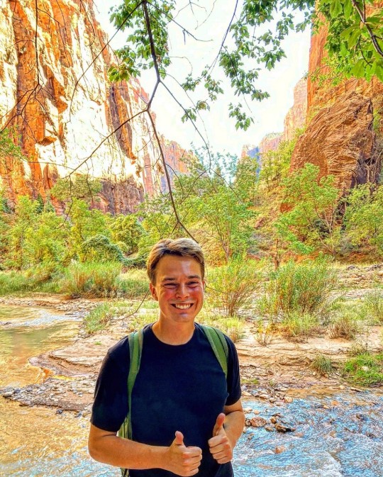
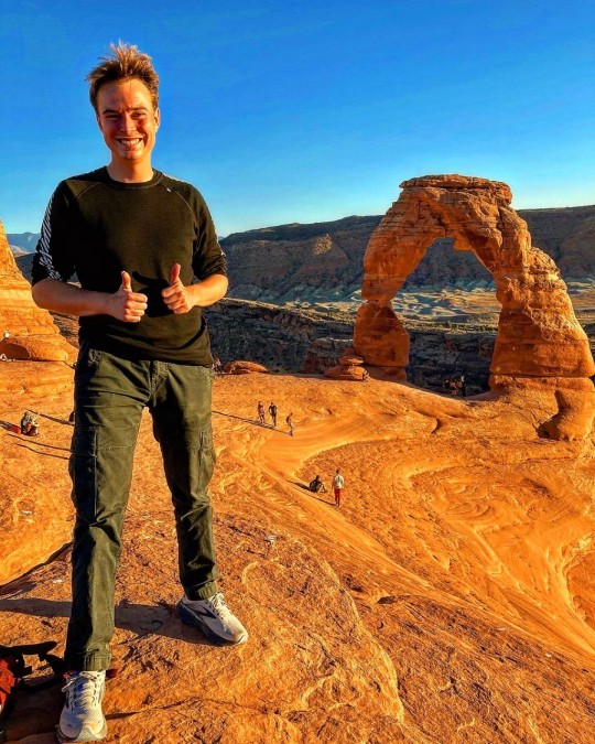
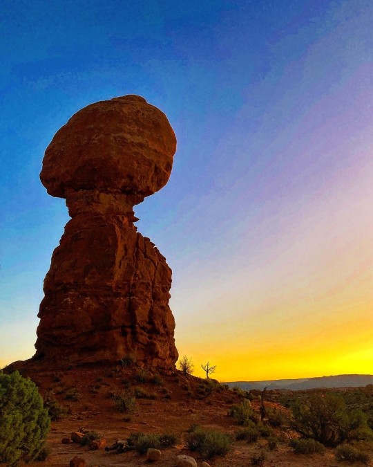
After a five-hour drive, I finally made it to Arches National Park. Seeing those sandstone arches gave me the goosebumps immediately. The vastness and greatness of this land is so amazing, and national parks, but also state parks, is a great way to explore the natural diversity of the United States. As home to more than 2,000 natural sandstone arches, Arches National Park has the highest density of natural arches in the world, including the iconic Delicate Arch, which is featured on several Utah car plates. In 1929, it was established as a national monument, but in 1971, it was re-designated as a national park. Today, Arches National Park is one of Utah’s finest tourist attractions and welcomed 1,238,083 visitors in 2020. The highlight of my visit was the enjoyable hike out to Delicate Arch, which is about 1.5 miles each way, and the late October weather made it a very comfortable experience. Delicate Arch is a 52-foot-tall freestanding natural arch, and if you look at my photo with me in front of it, you can kind off sense the grand size of this wonder. People close to it looks like ants. Another favorite stop on my visit to Arches National Park was Balanced Rock, which I enjoyed during sunset, where the rock becomes saturated in a red-orange color. Balanced Rocks is very easily accessible and definitely worth a stop.
After having spent a day hiking around Arches National Park, I decided to make my way toward Utah’s capital, Salt Lake City. Around 80% of Utah’s population is concentrated around a metropolitan region in the north-central part of the state known as the Wasatch Front, which consists of a chain of contiguous cities, including cities such as Provo, Logan, Ogden, and Salt Lake City. Driving into this area felt very different than the first part of my Utah trip where I could drive for hours without meeting to many people or too many gas stations for that matter.
Before we proceed into Salt Lake City, I’ll like to mention a few but important things about Utah. The uniqueness of Utah among American states is absolute. I find each state to be unique, but Utah is truly outstanding because of a certain religious group. With its vastness of horizon, its beautiful geologic formations and its wide aridity, Utah impresses anybody who want to enjoy Mother Nature at her best. However, Utah is not only home to natural miracles, but also the home of the Church of Jesus Christ of Latter-day Saints, a.k.a. the Mormons, who intertwined in the history of Utah. While Mormons seldomly call themselves Mormons, it will be used for clarity in this post. It has been gradually accepted and assimilated by the church. Latter-day Saints quickly became known as "Mormons" after the church was founded. The word comes from the Book of Mormon, a sacred book of scripture used by Mormons in addition to the Bible.
As of 2020, roughly 60 per cent of Utahns are Mormons. The political and economic power of the church is very strong as evidenced by the fact that the governor of Utah and both of the state's senators are Mormons, and so are all four of its members in the House of Representatives. Furthermore, 89 of the 103 lawmakers in the Utah Legislature are members of the Church of Jesus Christ of Latter-day Saints. The Mormon influence is also strong in Utah symbols. A word like "Deseret" appears a lot in Utah. It does not mean desert, but instead comes from the Book of Mormon (not the musical by Matt Stone and Trey Parker) where it meant honeybee, an animal considered to be self-sufficient and industriousness. As a result, Deseret was actually the proposed name for what would eventually end up becoming the Utah Territory and later evolved into the state of Utah. However, the state symbol of Utah continues to be a beehive and the symbol is represented on both the state seal, state flag, and is why the state is nicknamed the Beehive State.
So why did the Mormons end up in the middle of a desert? After Joseph Smith, the founder of the religion, was killed by an angry mob in Nauvoo, Illinois, a man named Brigham Young took over and led his followers to refuge in what would become Salt Lake City. Here, Young argued, Mormons could practice their faith freely because of its relative isolation. The approximately 1,300-mile journey from Illinois to Utah, known as the Mormon Trail, was harsh and though and plays a central role in the church’s history. One of the reasons to anti-Mormonism was the religion’s practice and acceptance of polygamy, and it caused a lot of problems and distrust between the United States government and the Mormons. For almost 50 years, Utah tried to become a state. However, each time Utah was rejected because of polygamy. Finally, polygamy was abandoned as the price for admission to the union. Actually, most of Nevada, where iconic Las Vegas is located, was originally a part of the Utah Territory, which is interesting when you think about how opposite the two states are: Utah’s worst nightmare would probably be to become “a hub of sin,” where liquor and gambling reigns supreme.
The Mormons also have a Danish connection. The first wave of Danish migration to the United States was led by Mormon converts, who looked for Zion, the kingdom of God, in the United States. As a result, many Mormons today have Danish heritage. Actually, among those who followed Brigham Young to the desert, was a Dane named Peter O. Hansen, who today is considered one of the movement's pioneers. As the religious movement grew, they began to expand their mission work. They soon turned their attention to Denmark, which in 1849 introduced a constitution that guaranteed freedom of religion. The Mormons would send Hansen home to Copenhagen to proselytize among the Danes. While in Denmark, Hansen also worked on translating the Book of Mormon into Danish as the first foreign language. The Mormon mission in Denmark was extremely successful. While the new Danish constitution mandated religious freedom, many followers of new religious movements were harassed by the Danish population, which is one of the main reasons of why about 17,000 Danish converts would make the journey to the United States between 1850 and early 1900s. Like many other emigrants of the time, they come from bottom of Danish society and they do not have the opportunity to finance the long and dangerous journey themselves. But the Mormons actually offered to cover the travel costs, obliging the emigrants to later make their labor available to the church. Town names still demonstrates the success of the early Mormon missions to Denmark – for example, Elsinore, Utah. Also, this Danish heritage is reflected at the Salt Lake City Cemetery, where Danish names appears on various tombstones.
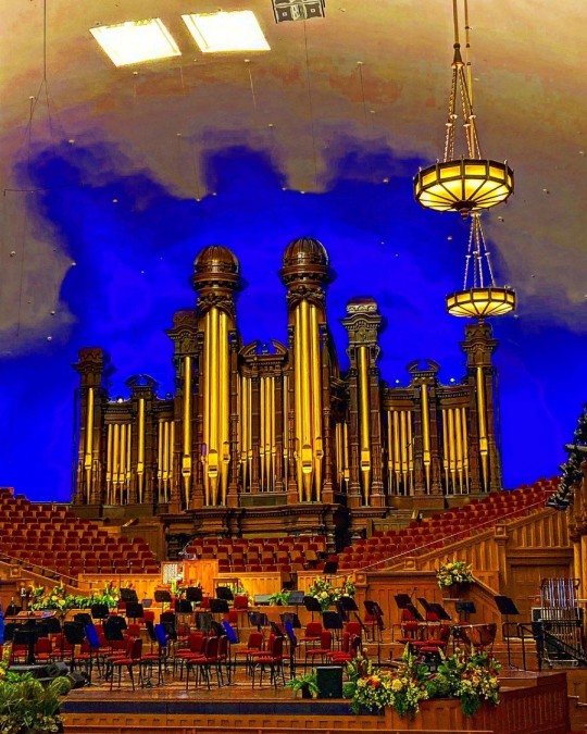
I made it into Salt Lake City, where I visited the Utah State Capitol, which is beautifully located on a hill that overlooks the downtown area – and actually looks a lot like the impressive U.S. Congress in Washington, D.C. Next, I visited the Mormon Tabernacle with its celebrated organ and even more celebrated acoustics. Next to the Mormon Tabernacle is the Salt Lake Temple, which is the chief cathedral of the faith. I also went to the Conference Center, which functions as a meeting hall for the church. It has 21,000 seats! I had a guided tour around the building, and when I mentioned where I was from, the guide showed me a replica of the iconic Christus, a white marble statue of the resurrected Jesus Christ. This iconic statue was made by Danish sculptor Bertel Thorvaldsen. Apparently, the church has made various replicas and placed them around their visitors’ center across the globe.
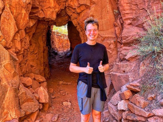
After spending a day in Salt Lake City, I decided to continue to Zion National Park, which I must admit is one of the most magical places I have been. The main highlight of the park is the Zion Canyon, which is a gorge flanked by waterfalls and colorful rock formations, many of which were given their biblical names by the first Mormons who arrived in the area in 1858. However, various Native American tribes had also lived in the area in earlier periods.
What today is called Zion National Park actually started as a national monument in 1909 when President William Howard Taft designated Mukuntuweap National Monument. In the 10 years until it became a national park, it was expanded, and its name was changed to Zion. In many national parks, you can usually drive around in your own car, but Zion closes the road seasonally and instead operates a free bus system, where you can jump on and off at various points throughout the park. I took the bus all the way to the end at the Temple of Sinawava, named after the Paiute tribe’s coyote deity, and then hiked along the Riverside Walk, a 2-mile round trip. It is all paved, but you can easily exit the path and walk along the river, which offers stunning views. At the end of the Riverside Walk you’ll have the option to continue into the Zion Narrows. However, you’ll need water shoes, because you’ll walk in the river. Afterwards, I went up Angel’s Landing, which gives you a perfect view of the Zion Canyon. But be warned: It’s a steep hike, but it’s worth every step.
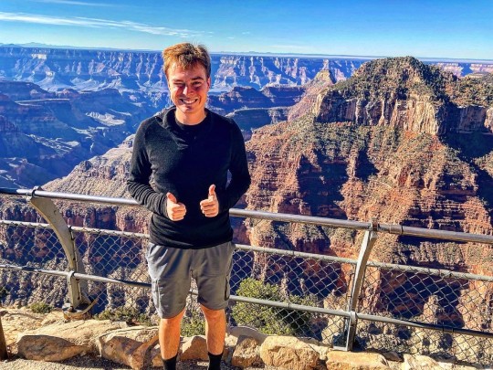
Southern Utah is home to five epic national parks (Arches, Bryce Canyon, Canyonlands, Capitol Reef, and Zion), and as a result, Utah has the third most national parks of any state after Alaska and California, so there is really much to see in this beautiful state. My journey continued to Arizona in order to visit the North Rim of the Grand Canyon, which is the least visited part of this famous national park. According to the National Park Service, only 10 percent of all Grand Canyon visitors goes to the North Rim, so it less way travelled. Several years ago, I went to the South Rim, so it was really wonderful to see how different this part is. I had good time conquering the canyons, and while much can be said about the Grand Canyon, I’ll end with an elegant quote from Theodore Roosevelt, who said the following when he visited the Grand Canyon in 1903:
“The Grand Canyon fills me with awe. It is beyond comparison—beyond description; absolutely unparalleled through-out the wide world ... Let this great wonder of nature remain as it now is. Do nothing to mar its grandeur, sublimity and loveliness. You cannot improve on it. But what you can do is to keep it for your children, your children's children, and all who come after you, as the one great sight which every American should see.”
With that beautiful quote I’ll end this first part of my trip. I didn’t have time to describe all the food that I had, but I sure had a lot of great burritos, enchiladas, tacos, and chile, as I drove across this wonderful part of the United States.
On the next part of the part of my Southwestern journey, I will be writing about my experiences at Monument Valley in the Navajo Nation, the Four Corners, Mesa Verde National Park and Great Sand Dunes National Park and Preserve.
1 note
·
View note
Video
Devil's Bridge and a Backdrop of Soldier Heights in Coconino National Forest by Mark Stevens
Via Flickr:
From an overlook to the natural bridge in between people going out for they photo opportunities from others. From this high point, I felt I was able to create that sweeping view across this north Arizona landscape and avoid flattening out high ground present around this area.
#Arizona Petrified Forest National Park and Sedona#Azimuth 37#Blue Skies#Bridge#Central Arizona Highlands#Coconino National Forest#Colorado Plateau#Day 5#Devil's Bridge#Devil's Bridge Trail#Devil's Bridge Trail No. 120#DxO PhotoLab 4 Edited#Flagstaff Area#Forest#Forest Landscape#Hillside of Trees#Intermountain West#Landscape#Landscape - Scenery#Looking NE#Natural Bridge#Nature#Nikon D850#No People#Outside#Pinnacles#Rock Spires#Rolling Hillsides#Sandstone Bridge#Sandstone Mountains
0 notes
Video
What a Wonderful Way to Experience a Sunday in Coconino National Forest by Mark Stevens
Via Flickr:
A setting looking to the northwest while hiking and taking in views over nearby evergreens and then to eroded formations in the high ground present. This is along the Fay Canyon Trail in Coconino National Forest.
#Arizona Petrified Forest National Park and Sedona#Azimuth 293#Blue Skies#Central Arizona Highlands#Coconino National Forest#Colorado Plateau#Day 6#DxO PhotoLab 4 Edited#Fay Canyon Trail#Fay Canyon Trail No. 53#Flagstaff Area#Forest#Forest Landscape#Hillside of Trees#Intermountain West#Landscape#Landscape - Scenery#Looking NW#Nature#Nikon D850#No People#Outside#Project365#Red Rock-Secret Mountain Wilderness#Rolling Hillsides#Sandstone Mountains#Scenics - Nature#Sedona Area#SnapBridge#Sunny
0 notes
Text
Best Places to Visit in Denver While Driving Around
Denver's outdoorsy vibe is best experienced on a city tour by car. Denver parking isn't going to be a big challenge. You can easily access several affordable and safe Denver parking lots and garages near the must-visit places in the city. From galleries, museums, and parks to eclectic eateries and shopping streets, there's so much to keep your day or two packed in the city of Denver.
Shop and Dine at Larimer Square
Larimer Street began west of Cherry Creek in Auraria before Denver City was founded in 1858. Since then, this historic block has served as the center of the city, and today it is on one of Denver's must-see spots. You will spend hours here, and not all of it is about gazing at well-preserved Victorian buildings or souvenir shopping. This commercial street is brimming with cafes and restaurants serving various cuisines – many of them come with outdoor seating to give you a lively downtown vibe. At night, the string lights twinkling above, and the live entertainment on the square will put you in a festive mood.
Parking in limited in this pedestrian-friendly area. It is recommended that you book a spot in one of the downtown Denver parking lots. You'll find cheaper Denver parking on Market Street and Tremont Place nearby.
Explore Flora and Art at the Denver Botanic Gardens
Spread over 24 acres of Cheesman Park in downtown Denver, Denver Botanic Gardens is home to exotic flora and outdoor sculptures. Over 50 landscapes at the garden, including a traditional Japanese garden and a South African plaza, welcome visitors every season. Touring art exhibitions and seasonal events are also held here year-round; the Summer Concert and the Christmas Lights display attract both locals and visitors alike. If you're here with friends and family or by yourself, expect to spend at least a few hours enjoying the gardens and capturing them in your cameras.
The main entrance to the gardens is at the Bonfils-Stanton Visitor Center on York Street. Denver parking lots near the Botanical Gardens can be found on University Boulevard and Josephine Street.
Get Up Close with Nature at the Denver Zoo
Primate Panorama, Tropical Discovery, Predator Ridge, Bear Mountain, Elephant Passage, and more exciting exhibits make this 80-acre zoological garden one of the most sought-after attractions. Over 600 species thrive in naturalistic enclosures at this zoo rather than in cages. The friendly zookeepers are always happy to help you get to know the animals better, particularly during feeding times. From penguins to elephants and everything in between, close encounters with nature will make sure you have a good time here, especially with children. Check out the nursery for a quick dose of cuteness from the baby animals. If you're visiting in the winter months, you can't afford to miss the 'Denver Zoo Lights' for a perfect night stroll under the festive lights!
Denver Zoo is a popular place to visit in Denver throughout the year. Finding a parking spot could be a hassle during peak hours. It's best to book a parking spot nearby — you'll find affordable Denver Parking lots around Park Avenue.
Play and Party at Red Rocks Park and Amphitheatre
The rugged sandstone surrounding this one-of-a-kind concert venue presents one of Denver's most mesmerizing visual treats. But that's not all! The park and its trails are nature's gifts to those who love working out in the open or even just enjoy the scenery. With fantastic views of the Rockies, the photographs here come out as nothing short of breathtaking, no matter where you pose. The amphitheater has hosted some of the greatest names in music — but no matter who the artist is, the excellent acoustics of the venue guarantees concertgoers a unique experience.
Red Rocks Park and Amphitheater are located about 16 miles west of downtown Denver, and the easiest way to get here is by car. However, it might not be easy to find a Denver parking spot during events. It is recommended that you reach the venue early for a hassle-free experience.
Check-in at the Denver International Airport (DIA)
Welcome to the largest airport in North America! With over 20 airlines providing non-stop flights to 215 destinations, there is a strong chance that you will visit the DIA at least once on your travels. The best way to spend your time here is to experience all the exciting facilities at the airport. Want to try the local flavors? Head over to the Denver central market. Shopping on your mind? The 2600 sq. ft. SkyMarket will take care of retail therapy. Make your way to the Native American Exhibition at the Jeppsen Terminal for a slice of Colorado culture. Don't forget to catch the breathtaking view of the Rockies by the C23 and C24 gates.
Denver Airport Parking is available at the East and West Parking Garages near Jeppsen Terminal and the East and West Economy Lots. You'll also find cheaper off-site DIA parking on Kittredge Street and Ouray Street in the vicinity.
Nature, art, culture, and cuisine — Denver has so much more to offer than just being a gateway to the Rockies. So, if you're passing the Colorado capital on your way to the ski slopes and hiking trails, take a day to visit and experience the unique attractions of America's Mile High city.
WAY
47627 Lakeview Blvd Fremont, California
408-598-3338
1 note
·
View note
Text
Places to visit in Delhi for couples-Top 10 Romantic Places for couples in Delhi
Magical, crazy and super polluted city- DELHI, allows you to really visit some amazing places and experience some golden time with your partner in the peak of its madness. Believe us or not, there are few heavenly Places to visit in Delhi for couples.
In today’s time, when everyone is super busy, getting some quality time with each other seems like a dream for a couple. And when finally, you decide, most of the time gets wasted in searching for an ideal location for the occasion.
Delhi is a place bursting with brilliant things to do, explore and eat. Take a look at our list for some of the best Places to visit in delhi for couples
So, here we are sharing a few amazing Places to visit in Delhi for couples.
From October to April is the best time to visit. It can be warm and cold, but it’s bearable!
1. Lodhi Garden, Khan Market
One of the most beautiful places, Lodhi Garden can be the most pleasant picnic spot to visit in Delhi for couples. Situated in south Delhi, allow visitors to relax while enjoying the well-kept flowers beds and the scenery all around.
Location: Lodhi Estate, New Delhi
Distance from city centre: 15 km
How to reach: Jor Bagh is the nearest metro station to Lodhi Garden. You can also take an auto-rickshaw or cab.
2.Garden of Five Senses
This is a well-known place to visit for couples, where you can take a romantic walk with your love amidst lavish green places that are full of colourful flowers. This place is dotted with fountains, pools, statues, bamboo courts and has some eateries and places to enjoy.
Location: Freedom Fighter Colony, Near, Saket, New Delhi
Distance from city centre: 30 km
How to reach: Saket is the nearest metro station which is located in the yellow line.
3. Japanese Park
This is one of the most romantic places, where you can chat with a tree, watch the birds and relax. This park boasts of five lakes, where you can enjoy a boat ride. Try to visit during sunrise or sunset to experience the most beautiful nature’s beauty.
Location: Swarn Jayanti Park, Sector 10, Rohini, New Delhi
Distance from city centre: 50 KM
How to reach: Rohini West metro station is the nearest metro station
4. The Atlantis Water Park
Want to do something thrilling and adventurous? Then this Atlantic water park would be great for you. This place has lots of thrilling rides, and there are plenty of places to eat and relax. Do Visit and Head early to beat the queues.
Location: Kalindi Kunj Park Adjacent to Kalindi Kunj Metro Station, New Delhi
Distance from city centre: 30 Minutes
How to reach: Kalindi Kunj Metro Station is the nearest metro station.
5. India Gate
The most amazing thing about India gate that it is accessible for 24*7, you can visit whenever you want. However, try to visit at night to enjoy the beautiful lighting and some street foods.
Location: New Delhi
Distance from city centre: 10 km
How to reach: Central Secretariat is the nearest metro station
6. Purana Quila
This red sandstone structure is one of the oldest Quila with green lawns and lake, is a perfect place to explore with your loved one. Boating is another added attraction for visitors.
How to reach: Nearest Metro Station is Pragati Maidan for reaching here.
7. Music & Mountains
This is one of the most lovely places for spending quality time for a couple. Its charming layout and gorgeous view, and of course delicious foods make everyone come here, especially to couples for a beautiful candlelight dinner.
Location: M Block Market, Greater Kailash 1, New Delhi
Timing: 11 am to 12.30 pm
8. Indian Mountaineering Foundation
If you want to spend some peaceful time alone with your beloved one, knowing each other, this place is all heaven for you. The Indian Mountaineering Foundation allows making your bond stronger. However, make sure to book your slot in advance.
Location: South Campus, South Moti Bagh, New Delhi
Timings: (Monday closed) 9 am to 1 pm & 4 pm to 8 pm
9. Connaught Place
Well-known for its beautiful white buildings, Connaught place reflects the colonial influence. It is one of the crowded places to hang out, but offers a range of shopping, eating out and sitting. Christmas eve is one of the most peak times to visit here when the whole area is lit up, and there’s a celebratory vibe all around.
Distance from city centre: 8 km
How to reach: Rajeev Chowk is the nearest metro station
10. Mehrauli Archaeological Park
This is one of the couple hangout places in Delhi where you can spend an amazing time with your love. This is just a two-minute walk away from Qutub Minar, and well known for having over a hundred historical structures. Experiencing through its green gardens is one of the most romantic things to do in Delhi for couples.
Location: Anuvrat Marg, Mehrauli, New Delhi
Distance from city centre: 29 km
https://tourwithrahul.com/places-to-visit-in-delhi-for-couples/
1 note
·
View note
Video
Treating Myself to Another of Nature's Amazing Outposts in Coconino National Forest by Mark Stevens
Via Flickr:
From a rise while hiking along the Devil's Bridge Trail one morning in Coconino National Forest. The view is looking to the north-northwest and using the hiking trail itself as a leading line in the lower portion of the image. From this higher point and by angling my Nikon SLR camera slightly downward, I could create a little more of a sweeping view across this north Arizona landscape. I then cropped portions of the skies above to create a more panoramic setting for the final image.
#Arizona Petrified Forest National Park and Sedona#Azimuth 341#Blue Skies#Central Arizona Highlands#Coconino National Forest#Colorado Plateau#Day 5#Devil's Bridge Trail#Devil's Bridge Trail No. 120#DxO PhotoLab 4 Edited#Flagstaff Area#Forest#Forest Landscape#Hillside of Trees#Intermountain West#Landscape#Landscape - Scenery#Looking NNW#Maroon Mountain#Nature#Nikon D850#No People#Outside#Pinnacles#Portfolio#Project365#Rock Spires#Rolling Hillsides#Sandstone Mountains#Scenics - Nature
1 note
·
View note
Text
Bangalley is a project designed by Casey Brown Architecture. A home inspired by its location, perched on a rising monolithic headland of sandstone and shale, jutting out into the Pacific Ocean just north of Sydney in the beachside suburb of Avalon. Designed to respond to this dramatic environment with a rustic rugged exterior and a raw but highly crafted interior. Photography by Charlie Baker, Michael Nicholson.
Marine Pde. North Avalon
.
Marine Pde. North Avalon
Marine Pde. North Avalon
Marine Pde. North Avalon
Marine Pde. North Avalon
Marine Pde. North Avalon
Marine Pde. North Avalon
Marine Pde. North Avalon
Marine Pde. North Avalon
Marine Pde. North Avalon
Marine Pde. North Avalon
Marine Pde. North Avalon
Marine Pde. North Avalon
Marine Pde. North Avalon
Marine Pde. North Avalon
Marine Pde. North Avalon
Marine Pde. North Avalon
Marine Pde. North Avalon
Marine Pde. North Avalon
Marine Pde. North Avalon
Marine Pde. North Avalon
Marine Pde. North Avalon
Marine Pde. North Avalon
Marine Pde. North Avalon
Marine Pde. North Avalon
Marine Pde. North Avalon
Marine Pde. North Avalon
Marine Pde. North Avalon
Marine Pde. North Avalon
Marine Pde. North Avalon
Marine Pde. North Avalon
Briefed by a couple of journalist empty nesters to ‘do the site justice’, ‘be part of nature’ and to ‘last 100 years’. A rigorous design process ensued, before a topographical response produced a series of steeped, staggered and linked blocks or pavilions set carefully amongst the boulders and twisted tea trees strewn over the headland.
Constrained by 3 massive Norfolk pines, flame zone bushland, a precipitous cliff edge and arduous council assessment, the site enjoys dramatic long distance southern ocean and coastline views as well as immediate near vertical views over the cliff edge to surfers and dolphins at Avalon Beach.
Highly visible from the popular public beach, the house replaces a rendered pink Tuscan style villa with a modest sized 350m2 house rooted in the hillside on 3 tectonic platforms enclosing a sun drenched and wind sheltered entry courtyard to the North, while overlooking the ocean and beach to the South and West
The scale, form and material pallet all seek to work with the terrain; cantilever terraces and balconies, exposed hoods and deep recessed openings ensure light and shade enhance the modulated facades. The five attached pavilions are linked by a double cross over axis, directing the entry and vertical movement pattern of the house and aligning with the two principal aspects the house enjoys – the long distance southern coastal view and immediate western beach view.
Vertically, the plan is arranged into three functional areas; the top floor private master suite, the ground floor garden level comprising the kitchen, dining, living and studies, and the lower cave like sheltered guest rooms tucked into and between the rocks.
Access is via a battle axe drive through a Corten and copper gatehouse into a sheltered garden court dominated by a giant Norfolk pine tree. A vaulted entry canopy projects into the courtyard, appearing to float inside while supported externally by a natural sandstone column found on the site. The house’s cliff-top aspect is completely concealed until the front door is opened revealing a double height space aligned with the coastal headlands, stepping down into the main living room.
The tectonic expression of the Ken Murtagh engineered concrete skeleton inside and out provides large openings protected from sun and rain while reflecting the horizontal layering of the cliffs below. The living room has fully retractable doors to two sides allowing a panoramic corner view and access to the terraces, made possible by a slender load defying brass clad post.
The buildings materiality is raw as the brief required. Constructed both inside and outside from 500×40 bricks by S. Anselmo. Smoky burnt grey/black bricks externally blend with the weathered sandstone surrounds. White bricks internally create an ever changing play of patterns and light as the sun moves around the building. Stone floors throughout reinforce the earthy materiality of the spaces while vaulted timber ceilings rise to northern rooflights flooding south facing rooms with light and sun. Fine brass railings mellow in the sea air, and allow views through to the ocean and surrounding heathland. All timber is FSC Certified Mailkaro including the double glazed Praarhammer fabricated Bal 40 windows and doors.
Central to the house is a finely crafted floating concrete stair connecting the 3 levels featuring a brass sculptured screen by Caroline Casey who was also responsible for all the highly resolved and detailed joinery and furnishings throughout the house.
Bangalley by Casey Brown Architecture Bangalley is a project designed by Casey Brown Architecture. A home inspired by its location, perched on a rising monolithic headland of sandstone and shale, jutting out into the Pacific Ocean just north of Sydney in the beachside suburb of Avalon.
#Bangalley#bathroom#bedroom#Casey Brown Architecture#house#house idea#houseidea#kitchen#living#myhouseidea#villa
3 notes
·
View notes
Photo
Natural Materials in Architecture
By and large, the development and progress of architecture has depended on rocks, either in their natural state or processed to create other building materials. Without rocks, the majority of buildings in Britain and Europe today would not exist. The choice of building materials for structures of any kind depends on their availability. In North Africa, for example, where rock is hard to come by but clay soil is abundant, the mud-brick and adobe technique developed. However, on the alluvial plains of Central Europe construction based on stone and wood has been commonplace since very early times. Over the centuries, virtually all of the world’s cultures have developed techniques enabling them to use stone as a building material, attracted by the strength and permanence it offers builders.
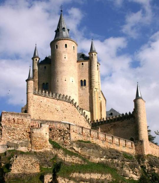
Monumental structures, like palaces and fortresses such as that of Segovia (post picture), have been built since antiquity using the ashlar technique, which involves joining ashlars, or blocks, of stone, with binder of some sort. The types of stone most commonly used in building work are limestones, hard sandstones and granites for structural elements (blocks, columns, lintels); slates, quartzites and marbles for paving stones; and limestones, clays or gypsums for binders.
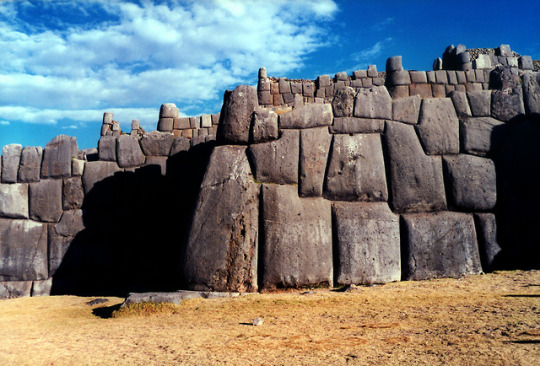
Without doubt, the wall is one of the most basic, and dramatic, structures in architecture. In ancient societies it was essential for defence, and our ancestors exhibited great skill in building them, both as barriers (such as Hadrian’s Wall, UK) and in buildings such as castles. The Incas developed incredible wall-building techniques. The Peruvian fortress of Sacsahuaman in Cuzco: the enormous blocks were assembled dry, without mortar of any kind, and are fitted so closely together that not even a knife blade can be inserted between them.
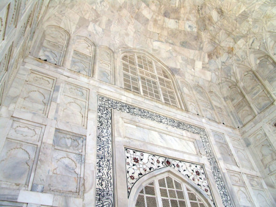
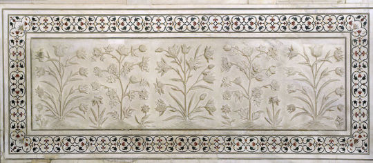
If ever there were builders known for their consummate skill in using ornamental stone in architecture, they were the builders of the palaces of Mongul India and, in particular, of Taj Mahal. This palace-mausoleum was constructed for the beloved wife of King Sha Jahan, Mumtaz Mahal, who died giving birth to their fourteenth child. The Taj is built in white marble; red sandstone and black marble were used for the boundary walls. To add to its beauty, the king jade, jaspers, jades, turquoises, sapphires, lapis lazuli and carnelians brought on the backs of elephants from all over Asia to be set in the marble surfaces.
~ JM
Segovia Image Credit: http://famouswonders.com/alcazar-of-segovia/ Cuzco Image Credit: https://commons.wikimedia.org/wiki/File:Sacsahuaman_wall3.jpg Taj Mahal Image Credit: http://designlike.com/2011/12/05/100-most-famous-landmarks-around-the-world/ Taj Mahal Stones and Marbles: https://commons.wikimedia.org/wiki/File:Flowers_in_marble,_Taj_Mahal,_Agra,_India_1.jpg http://www.taj-mahal.net/augEng/textMM/materialsengN.htm More Info: Adobe and Mud-Brick technique: http://archaeology.about.com/od/africa/ig/West-African-Adobe-Buildings/ Ashlar Technique: http://www.wisegeek.com/what-is-ashlar-masonry.htm Sacsahuaman in Cuzco: http://www.cusco-peru.org/cusco-surroundings-cusco-sacsayhuaman.shtml Segovia Fortress: http://www.exploring-castles.com/alcazar_de_segovia.html http://famouswonders.com/alcazar-of-segovia/ Hadrian's Wall: http://www.visithadrianswall.co.uk/hadrians-wall
#building#stone#construction#geology#marble#taj mahal#segovia#sacsahuaman#wall#engineering#the earth story#peru#cuzco#fortress
140 notes
·
View notes
Last Seen Blogs

lishan-lover
LiShan

nin-xo
Sensory Overload

ninagirlnow-blog
Giggletones.com

eddsworld-universe-guardian-blog
COMEN BACK!!!!!!

mars-alex-stewart
MarsAlexStewart