#post tropical cyclone lee
Text


Hurricane/post tropical cyclone Lee 🌊
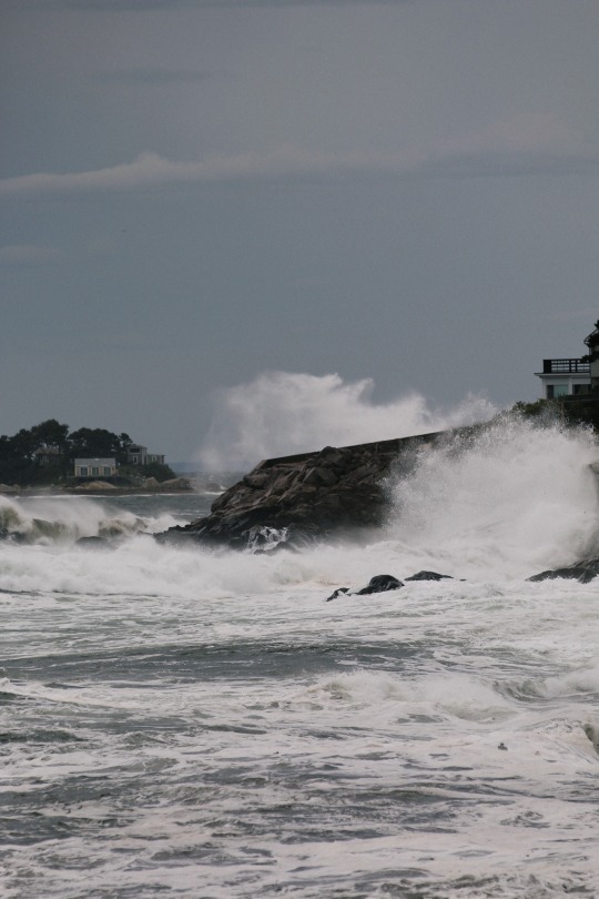
#went early this morning to catch the waves#was there for like almost 3 hours just watching#so many other peeps were there too#babe made a friend with a painter#she was taking photos in hopes to catch a good enough one to paint#I went and sat out on the rocks and almost got taken#a few inches closer to me and I’d be out with the fish#was so fucking cool#hearing the water slam into the rocks is incredible#sounds just like thunder#this is the best place to be when storms are bad#oh!#I also randomly sat down#and found a little bee#loved him#anywho!#bad omens soon#best day? yeah#hurricane lee#post tropical cyclone lee#storm#ocean#nature#mine#photographers on tumblr#photography
3 notes
·
View notes
Text
#marshfield#massachusetts#plymouth county#ocean#brant rock#cloudy#rain#waves#lee#post tropical cyclone lee#beach#sea#september#summer#wind
0 notes
Text
2 notes
·
View notes
Text


I’m near the little black dot on the map. You can see where the edge of post-tropical cyclone Lee is now. The pictures are views of it from my neighborhood. It’s been visible for over 24 hours and has shifted to the north.
245 notes
·
View notes
Text
Atlantic Tropical Weather Outlook issued by the National Hurricane Center in Miami, FL, USA
2023-09-17, 08:00 EDT

Active Systems: The National Hurricane Center is issuing advisories on Post-Tropical Cyclone Lee, located just north of Prince Edward Island, Canada, on Tropical Storm Margot, located over the central subtropical Atlantic, and on Tropical Storm Nigel, located over the central tropical Atlantic.
Eastern Tropical Atlantic: A tropical wave is forecast to move off the west coast of Africa by Wednesday. Gradual development of the wave will be possible thereafter and a tropical depression could form late this week or next weekend while the system moves westward across the eastern tropical Atlantic.
* Formation chance through 48 hours...low...near 0 percent.
* Formation chance through 7 days...medium...40 percent.
$$ Forecaster D. Zelinsky
#bot post#meteorology#weather#tropical weather#tropical storm#tropical depression#hurricane#atlantic#atlantic ocean#caribbean#gulf of mexico#noaa#national oceanic and atmospheric administration#nhc#national hurricane center
2 notes
·
View notes
Text

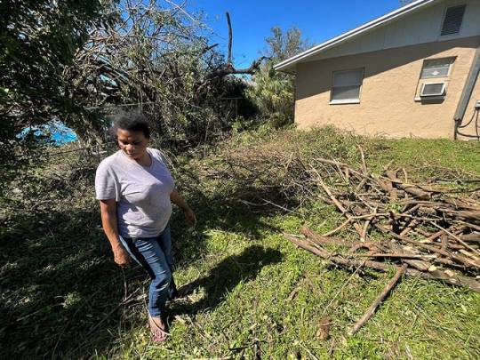
FORT MYERS, Fla. – Shannon Tolbert and her cousins had no power two days after Hurricane Ian made landfall, so they cooled off in the shade of a compact SUV trunk Friday afternoon in front of the house.
They live in Dunbar, a historically Black area of Fort Myers that also houses a growing Hispanic and Latino population. Lining the roads were uprooted trees, straggled power lines, piles of fence remnants and storm debris from Ian’s Category 4 winds.
“Every time we have a storm, we’re the last ones to get power,” said Tolbert's cousin, lifetime Dunbar resident Valorie Simmons, a steel factory worker. Simmons' daughter Cherell Lindsey nodded along with Tolbert's daughter, who was lounging in the SUV's back seat.
“It’s expected," Simmons said. "Where it's Black and brown people ... we get it last."
Black residents of Dunbar said they fear the aftermath of Hurricane Ian will be no different, saying the city’s wealthier, majority-white neighborhoods typically have better power grids and get power back sooner.
“That’s going to be No. 1 priority. Anything where it’s majority people of color, it’s going to be last,” said Tolbert, a dental assistant.
About 1.3 million Floridians remained without power Saturday, officials said during a weekend news conference. Florida Power and Light Company said it's working on restoring power to affected customers, reporting as of 10 a.m. it has restored power "where possible" to two-thirds of customers, according to a Saturday news release from the company, with about 700,000 remaining.
BARRIER ISLAND:Amid 'gut-wrenching' destruction from Ian, Florida residents band together
'NIGHTMARE':After Hurricane Ian, Fort Myers residents mourn low-lying neighborhoods
The company estimated power for "most customers" in Fort Myers' Lee County, where about 73% of households still lack power, would be restored by Saturday.
"The road is challenging, but we won't back down and we won't stop working until every customer is restored," Eric Silagy, CEO and chairman, said in a news release.
Still, Dunbar residents have grown accustomed to relying on themselves and looking out for each other. Tolbert conserves gasoline usage, only running the generator for the refrigerator. She keeps the windows open at night to let brisk air in.
“We can survive off anything,” Tolbert said. She, Simmons and Lindsey said care packages are rare.
"If they do do it in our neighborhood, it's only one stop, one shop. And they don't do it in multiple places," Lindsey said.
In Dunbar, streets and parks are named for prominent late Black activists and leaders: Roberto Clemente, a Puerto Rican baseball player of African descent also known for his charity work in Latin America; Ella Mae Lee, philanthropist and entrepreneur; and Veronica Shoemaker, a civil rights activist, flower shop owner and first Black City Council member.
A few minutes away off Michigan Avenue, a half mile north of the Lee County Black History Society, lives Lorieann Thurman. She’s a truck driver at a waste management facility that she says is now underwater on leveled Fort Myers Beach.
“I’ve been here all my life, but this was the most traumatic storm ever. Trees down, and people’s windows blowing out of their house,” she said. “(Ian) was very disrespectful because he didn't just come and go, he just stayed right there. He lingered. He made sure he came to show you that God is still in control.”
Roughly 16 miles from the Gulf Coast, the Dunbar community is a few miles south of the Caloosahatchee River that runs through the city. It's tucked in 33916, a ZIP code with a median income of $37,740, according to U.S. census estimates, and a per capita income of $21,700. About a quarter of people live below the poverty line.

WATCH:South Carolina feeling the effects of Hurricane Ian
WATCH:Ian resurges before landfall in South Carolina, then weakens to post-tropical cyclone
The Dunbar area was in Evacuation Zones C and D. While risks are less, the zones are still vulnerable to serious hurricane damage. But storm preparation to weather any aftermath can be difficult for low-income households.
“Everybody don't have or couldn't go out and get what they needed because they didn't have the finances,” she said.
Thurman echoed Tolbert on the power situation.

Her cousin across the street, Latronia Latson – 61, a former private duty nurse for seniors who is now on disability – said she was afraid to evacuate because of health concerns. She didn’t want to shelter with others for fear of catching the coronavirus. Her windows were blown out and along with other debris, a tall palm tree toppled in her yard.
“The fight with the wind – we had mattresses and stuff up to the window, and that wind was so strong, it was fighting against us,” said Latson, who lives there with her granddaughter and daughter. “We did what we had to do to survive.”
On Friday afternoon, Haitian immigrant Marie Fleurette Radius sprawled on a blanket on the front porch with her baby granddaughter Sarah-Gasnaya, her grandson Christ was playing in the yard and steam was rising from a pot of rice reheating on the back porch.

Their big sister, Lindsay Garconvil, 15, said her window broke as she was on her bed, shards of glass surrounding her. The family rode out the hurricane in a different rental, which sustained more damage, so they found this house to move into. Still, it wasn’t without its own damage, with leaks and broken windows.

Now without power, when night sets in, Radius said baby Sarah is afraid of the dark, so they have to leave a flashlight on.
Radius called to check on her daughter, the kids’ mom, Marie Stinfil, a nursing assistant who was at work that day, two days after the storm.
“It’s very stressful,” Stinfil said by phone, exasperated. “We lost a lot of food.”
Back a couple of miles west, Tolbert recalled stopping by an eatery that took only cash after the storm. A white couple in front of her didn’t have any, just cards. She insisted to pay the $35 bill for them. “I said, ‘you don't have to pay me back. Don't even worry about it,’” she said.
Tolbert and her cousins all said – they just "keep pushing," and help each other.
#After Hurricane Ian hits Fort Myers#Black neighborhood residents say they aren’t counting on much help#hurricane ian#Black Residents of Fort Myers Neglected post hurricane ian#florida#racism in rescue#Dunbar
5 notes
·
View notes
Text
Francine weakens as it moves inland bringing additional rain
Almost all warnings for what had been Category 2 Hurricane Francine were canceled Thursday night, a day after the storm named slammed into the Louisiana coast with heavy rains and 100-mph winds.
By late Thursday, Francine was a post-tropical cyclone, and flood watches and wind advisories were in effect for parts of the Mississippi Delta, the Tennessee Valley and the Southeastern U.S. at 11 p.m. ET, the National Hurricane Center said.
But what did remain in the wake of the storm that made landfall in Terrebonne Parish, Louisiana, were more 150,000 customers without power in the state, according to the tracking website poweroutage.us.
Louisiana Gov. Jeff Landry toured the hardest-hit areas across his state Thursday. “Power is the most important thing that we need right now,” he said on NBC News’ “Hallie Jackson NOW.”
Landry said he hoped to have power fully restored by Sunday and urged residents to stay off the roads so utility workers could do their jobs.
There have been no reports of deaths related to the storm.
In New Orleans, the din of portable generators was the soundtrack across much of the city Thursday as entire neighborhoods lost power, and streets were blocked by debris and downed oak and cypress trees.
The aftermath of a deluge from Hurricane Francine in Metairie, La., in Jefferson Parish, on Wednesday night. Matthew Hinton / AP
Amid the mayhem, stories began to emerge of ordinary people performing extraordinary exploits to save their neighbors from harm.
A good Samaritan named Miles Crawford smashed a window to rescue a driver from a fully submerged pickup truck that was caught in the floodwaters Wednesday evening beneath the Canal Street underpass in New Orleans, NBC affiliate WDSU reported.
Crawford said he sprang into action after WDSU reporter Jonah Gilmore, who was doing a live shot in the area, spotted the submerged pickup and flagged down a nearby police officer.
“I’m a nurse, so got to save lives, right?” Crawford, who works at the University Medical Center, told The Associated Press.
Packing 100 mph winds, Francine roared ashore in Terrebonne Parish at around 5 p.m. local time as a Category 2 hurricane, battering a fragile coastal section of Louisiana that hasn’t fully recovered from a series of devastating hurricanes in 2020 and 2021.
Moving at a fast clip, Francine barreled into New Orleans, pounding the hard-pressed city with torrential rains and tearing the roofs off hundreds of buildings. The low-lying city was quickly deluged, with 7.33 inches of rain reported at New Orleans International Airport.
In the New Orleans suburb of Kenner, 100 homes were swamped by rainwater. Over in nearby Metairie, floodwaters turned streets into impassable canals.
“Now is not the time to be out on the roads,” Jefferson Parish President Cynthia Lee Sheng warned on X in the midst of the storm. “All residents are urged to stay home.”
In Lafourche Parish in southern Louisiana, 26 people trapped by rising floodwaters were rescued, local officials said.
Some of those affected by power outages may not get electricity back for days.
The utility company Entergy says it may not be able to restore power to 90% of Terrebonne, Lafourche and Assumption parishes until 10 p.m. Monday.
The east bank of Orleans Parish has an estimated restoration time of 10 p.m. Saturday, the company said in a list of expected times released Thursday.
The storm, even though it is now a post-tropical cyclone, was still posing a heavy rainfall threat for parts of northern Mississippi, northeast Arkansas, southwest Kentucky and western Georgia on Thursday night, and those areas could get up to 4 inches of additional rain, the National Hurricane Center said.
That could be enough to cause considerable flash flooding and urban flooding, it warned.
Corky Siemaszko
Corky Siemaszko is a senior reporter for NBC News Digital.
Antonio Planas and Phil Helsel contributed.
Source link
via
The Novum Times
0 notes
Text
2023 Atlantic Hurricane Season Summary
Boo, bitches, he's back with more Hurricane Info! I'm probably going to do this for the EPac too this time (what can I say, your boy branched out this year).
ACE (Accumulated Cyclone Energy) Score: ~145.5 Units (above normal)
This marks the 3rd year in the 2020's with an above average ACE score (2020 was considered "extremely active" and 2021 was "above normal").
Major Hurricanes (anything with 1 minute sustained winds of over 111mph or 178 km/h): 3
Hurricanes (anything with 1 minute sustained winds of over 74 mph or 119 km/h): 7
Named Storms*: 20 (fourth most active tropical cyclone season on record, tied with 1933)
*For the sake of this post I've chosen to count Subtropical Storm One as a named storm, I'll elaborate later.
Depressions: 21*
*Includes the unnamed Tropical Depression Twenty-One
One tropical disturbance was given the title of Potential Tropical Cyclone Twenty-Two in mid-November, but never formed into a storm or depression. This will forever be known as PTC 22, rip little guy.
This is the first year to have a nameable storm form in January since 2016 with Hurricane Alex, with Subtropical Storm One undergoing a subtropical transition on January 16th and managing to go semi-overlooked by the NHC until later in the season.
Another important thing to note is that we had a Category 5 Hurricane this year with Hurricane Lee, making this my first year to observe an operational Category 5 storm. Very exciting for me!
Current (December 1st, 2023) damage estimates: >3.09 Billion USD (2023)
STORM INFO:
Strongest Storm (Barometric Pressure): Hurricane Lee (926 mbar)
Strongest Storm (Wind Speed): Hurricane Lee (165 mph/270 km/h 1 minute sustained)
Longest Lasting Storm: Hurricane Philippe (12.75 days)
Crossover Storms: None
Number of Storms Your Local Weather Dingus Weathered: Zero!
This was my first Atlantic Hurricane Season to study now that I'm officially studying Meteorology in College, it almost feels surreal to me. This was my hyperfixation, but now this is what I'm planning on doing for the rest of my life. It's not gonna be all charts and rainbows, believe me it's gonna get beyond rough, but I'm willing to keep at it.
Next year's naming list starts June 1st with the name Alberto.
Goodnight Atlantic, rest well and please stop spitting on the Gulf Coast, we can't deal with it anymore.
#atlantic hurricane season#meterology#hurricaneseason#this is my life now#nogodonlyhurricane#theminstem
0 notes
Text
1 note
·
View note
Text
BAR HARBOR, Maine — Atlantic storm Lee — which made landfall at near-hurricane strength, bringing destructive winds and torrential rains to New England and Maritime Canada — kept weakening Sunday after officials withdrew warnings and predicted the storm would disappear early this week.
The U.S. National Hurricane Center said Sunday morning that the post-tropical cyclone was about 135 miles west of Channel-Port Aux Basques, Newfoundland. The top sustained wind speed was 45 mph with some higher gusts expected.
"Gradual weakening is forecast during the next couple of days, and Lee could dissipate on Tuesday," the U.S. hurricane center said.
The sky was sunny in Maine on Sunday morning. Gov. Janet Mills suspended a state of emergency. Less than 5% of electricity customers were still without power, down from 11% by midday Saturday during the height of the storm. In Canada, 14% of Nova Scotia had no electricity, down from 27% on Saturday, with smaller numbers in New Brunswick and Prince Edward Island.
The center discontinued a tropical storm warning for the coast of Maine late Saturday. It reported late Sunday morning that all tropical storm warnings for Canada were discontinued.
Storm surges were expected to subside on Sunday after being forecast as up to 3 feet on Saturday along coastal areas, the hurricane center said.
Fatality reported in Maine
A 51-year-old motorist in Searsport, Maine, died Saturday after a large tree limb fell on his vehicle on U.S. Highway 1 during high winds. The limb brought down live power lines and utility workers had to cut power before removing the man, who died later at a hospital, Police Chief Brian Lunt said.
A driver suffered minor injuries Saturday, after a tree downed by Lee went through his windshield on Route 11 in Moro Plantation, Maine, according to Maine State Police. John Yoder, 23, of Apple Creek, Ohio, attempted to stop but couldn't avoid the tree. Yoder suffered minor cuts but the other five passengers in the van were not injured. Police blamed high winds for the downed tree.
The storm was tracked as moving around 22 mph and expected to proceed northeast, taking the weather system across the Canadian Maritimes. Rainfall was expected to be an additional 1 inch or less for portions of eastern Maine, New Brunswick and Nova Scotia, the U.S. storm center said.
In Bar Harbor, Maine, the touristy gateway to Acadia National Park, a whale watch vessel broke free of its mooring and crashed ashore Saturday. Authorities worked to offload 1,800 gallons of diesel fuel to prevent it from spilling into the ocean.
Lee flooded coastal roads in Nova Scotia and took ferries out of service while fanning anxiety in a region still reeling from wildfires and severe flooding this summer. The province's largest airport, Halifax Stanfield International, canceled all flights.
"People are exhausted," said Pam Lovelace, a councilor in Halifax. "It's so much in such a small time period."
Hurricane-force winds extended as far as 140 miles from Lee's center, with tropical storm-force winds extending as far as 320 miles, enough to cover all of Maine and much of Maritime Canada.
The storm skirted some of the most waterlogged areas of Massachusetts that experienced severe flash flooding days earlier, when fast water washed out roads, caused sinkholes, damaged homes and flooded vehicles.
In eastern Maine, winds died down enough by late afternoon Saturday for utility workers to begin using bucket trucks to make repairs.
The entire region has experienced an especially wet summer, ranking second in the number of rainy days in Portland, Maine — and Lee's high winds toppled trees stressed by the rain-soaked ground in Maine, the nation's most heavily wooded state.
Cruise ships found refuge at berths in Portland, Maine, while lobstermen in Bar Harbor and elsewhere pulled traps from the water and hauled boats inland.
Billy Bob Faulkingham, House Republican leader of the Maine Legislature, and another lobsterman survived after their boat overturned while hauling traps ahead of the storm Friday, officials said.
The boat's emergency locator beacon alerted authorities and the pair clung to the hull until help arrived, said Winter Harbor Police Chief Danny Mitchell. The 42-foot boat sank.
"They're very lucky to be alive," Mitchell said.
Lee shared some characteristics with 2012's Superstorm Sandy. Both storms were once-strong hurricanes that became post-tropical cyclones — cyclonic storms that have lost most of their tropical characteristics — before landfall. But Sandy caused billions of dollars in damage and was blamed for dozens of deaths in New York and New Jersey.
Lee also was not anywhere near as severe as the remnants of Hurricane Fiona, which a year ago washed houses into the ocean in eastern Canada, knocked out power to most of two provinces and swept a woman into the sea.
Destructive hurricanes are relatively rare so far north. The Great New England Hurricane of 1938 brought gusts as high as 186 mph and sustained winds of 121 mph at Massachusetts' Blue Hill Observatory. There have been no storms that powerful in recent years.
Separately, Tropical Storm Nigel was strengthening and expected to become a hurricane by Monday, the U.S. hurricane center said. It appeared to pose no threats to the U.S. or Canada. It was about 990 miles northeast of the Lesser Antilles and about 1,115 miles east-southeast of Bermuda. It had maximum sustained winds of 60 mph and was moving north-northwest at 13 mph.
0 notes
Link
[ad_1] BAR HARBOR, Maine -- Atlantic storm Lee - which made landfall at near-hurricane strength, bringing destructive winds and torrential rains to New England and Maritime Canada - kept weakening Sunday after officials withdrew some warnings and predicted the storm would disappear early this week.The U.S. National Hurricane Center said Sunday morning that the post-tropical cyclone was about 70 miles (113 kilometers) west-northwest of Charlottetown, Prince Edward Island, and about 180 miles (290 kilometers) west of Channel-Port Aux Basques, Newfoundland. The top sustained wind speed had dropped to 45 mph (70 kph) with some higher gusts expected."Gradual weakening is forecast during the next couple of days, and Lee could dissipate on Tuesday," the U.S. hurricane center said.The sky was sunny in Maine on Sunday morning, where 5% of electricity customers were still without power, down from 11% by midday Saturday during the height of the storm. In Canada, 18% of Nova Scotia had no electricity, down from 27% on Saturday. The figure was 3% in New Brunswick, down from 8%, and less than 1% in Prince Edward Island, down from 3%.The center discontinued a tropical storm warning for the coast of Maine late Saturday and reported the Canadian Hurricane Centre had ended its tropical storm warning for New Brunswick and parts of Prince Edward Island.Storm surges were expected to subside on Sunday after being forecast as up to 3 feet (0.91 meters) on Saturday along coastal areas, the hurricane center said.A 51-year-old motorist in Searsport, Maine, died Saturday after a large tree limb fell on his vehicle on U.S. Highway 1 during high winds. The limb brought down live power lines and utility workers had to cut power before removing the man, who died later at a hospital, Police Chief Brian Lunt said.A driver suffered minor injuries Saturday, after a tree downed by Lee went through his windshield on Route 11 in Moro Plantation, Maine, according to Maine State Police. John Yoder, 23, of Apple Creek, Ohio, attempted to stop but couldn't avoid the tree. Yoder suffered minor cuts but the other five passengers in the van were not injured. Police blamed high winds for the downed tree.The storm was tracked as moving around 22 mph (35 kph) and expected to proceed northeast, taking the weather system across the Canadian Maritimes. Rainfall was expected to be an additional 1 inch (25 millimeters) or less for portions of eastern Maine, New Brunswick and Nova Scotia, the U.S. storm center said.A tropical storm warning remained in effect for parts of Nova Scotia, the Magdalen Islands and Prince Edward Island with strong winds possibly leading to downed trees and power outages, the center said.In Bar Harbor, Maine, the touristy gateway to Acadia National Park, a whale watch vessel broke free of its mooring and crashed ashore Saturday. Authorities worked to offload 1,800 gallons (6,813 liters) of diesel fuel to prevent it from spilling into the ocean.Lee flooded coastal roads in Nova Scotia and took ferries out of service while fanning anxiety in a region still reeling from wildfires and severe flooding this summer. The province's largest airport, Halifax Stanfield International, canceled all flights."People are exhausted," said Pam Lovelace, a councilor in Halifax. "It's so much in such a small time period."Hurricane-force winds extended as far as 140 miles (220 kilometers) from Lee's center, with tropical storm-force winds extending as far as 320 miles (515 kilometers), enough to cover all of Maine and much of Maritime Canada.The storm skirted some of the most waterlogged areas of Massachusetts that experienced severe flash flooding days earlier, when fast water washed out roads, caused sinkholes, damaged homes and flooded vehicles.In eastern Maine, winds died down enough by late afternoon Saturday for utility workers to begin using bucket trucks to make repairs.The entire region has experienced an especially wet summer, ranking second in the number of rainy days in Portland, Maine - and Lee's high winds toppled trees stressed by the rain-soaked ground in Maine, the nation's most heavily wooded state.Cruise ships found refuge at berths in Portland, Maine, while lobstermen in Bar Harbor and elsewhere pulled traps from the water and hauled boats inland.Billy Bob Faulkingham, House Republican leader of the Maine Legislature, and another lobsterman survived after their boat overturned while hauling traps ahead of the storm Friday, officials said.The boat's emergency locator beacon alerted authorities and the pair clung to the hull until help arrived, said Winter Harbor Police Chief Danny Mitchell. The 42-foot (12.8-meter) boat sank."They're very lucky to be alive," Mitchell said.Lee shared some characteristics with 2012's Superstorm Sandy. Both storms were once-strong hurricanes that became post-tropical cyclones - cyclonic storms that have lost most of their tropical characteristics - before landfall. But Sandy caused billions of dollars in damage and was blamed for dozens of deaths in New York and New Jersey.Lee also was not anywhere near as severe as the remnants of Hurricane Fiona, which a year ago washed houses into the ocean in eastern Canada, knocked out power to most of two provinces and swept a woman into the sea.Destructive hurricanes are relatively rare so far north. The Great New England Hurricane of 1938 brought gusts as high as 186 mph (300 kph) and sustained winds of 121 mph (195 kph) at Massachusetts' Blue Hill Observatory. There have been no storms that powerful in recent years.Separately, Tropical Storm Nigel was strengthening and expected to become a hurricane by Monday, the U.S. hurricane center said. It appeared to pose no threats to the U.S. or Canada. It was about 980 miles (1,575 kilometers) northeast of the Lesser Antilles and about 1,180 miles (1,895 kilometers) east-southeast of Bermuda. It had maximum sustained winds of 50 mph (85 kph) and was moving north-northwest at 14 mph (22 kph).The Associated Press contributed to this report. [ad_2]
0 notes
Text
Lee goes post-tropical before reaching Nova Scotia » Yale Climate Connections
Once a category 5 monster, Post-Tropical Cyclone Lee was pushing into far western Nova Scotia and New Brunswick on Saturday much larger in size but much weaker in strength than during its time in the tropics. Ferry crossings were cancelled across much of Atlantic Canada as the provinces hunkered down for high winds, rough seas, and heavy rain. Pockets of flooding were reported in Nova Scotia by…

View On WordPress
0 notes
Text
Atlantic Tropical Weather Outlook issued by the National Hurricane Center in Miami, FL, USA
2024-06-01, 08:00 EDT

Tropical cyclone formation is not expected during the next 7 days.
&&
Today marks the first day of the Atlantic hurricane season, which will run until November 30. The long-term averages for the number of named storms, hurricanes, and major hurricanes are 14, 7, and 3, respectively.
The list of names for 2024 is as follows:
Name Pronunciation --------------------------------------------------------------------
Alberto al-BAIR-toe
Beryl BEHR-ril
Chris kris
Debby DEH-bee
Ernesto er-NES-toh
Francine fran-SEEN
Gordon GOR-duhn
Helene heh-LEEN
Isaac EYE-zik
Joyce joyss
Kirk kurk
Leslie LEHZ-lee
Milton MIL-ton
Nadine nay-DEEN
Oscar AHS-kur
Patty PAT-ee
Rafael Rah-fah-EL
Sara SAIR-uh
Tony TOH-nee
Valerie VAH-lur-ee
William Will-yum
A full list of Atlantic basin tropical cyclone names and pronunciations can be found at: www.nhc.noaa.gov/pdf/aboutnames_pronounce_atlc.pdf
This product, the Tropical Weather Outlook, briefly describes significant areas of disturbed weather and their potential for tropical cyclone formation during the next seven days. The issuance times of this product are 2 AM, 8 AM, 2 PM, and 8 PM EDT. After the change to standard time in November, the issuance times are 1 AM, 7 AM, 1 PM, and 7 PM EST.
A Special Tropical Weather Outlook will be issued to provide updates, as necessary, in between the regularly scheduled issuances of the Tropical Weather Outlook. Special Tropical Weather Outlooks will be issued under the same WMO and AWIPS headers as the regular Tropical Weather Outlooks.
A standard package of products, consisting of the tropical cyclone public advisory, the forecast/advisory, the cyclone discussion, and a wind speed probability product, is issued every six hours for all ongoing tropical cyclones. In addition, a special advisory package may be issued at any time to advise of significant unexpected changes or to modify watches or warnings.
NHC has the option to issue advisories, watches, and warnings for disturbances that are not yet a tropical cyclone, but which pose the threat of bringing tropical storm or hurricane conditions to land areas within 48 hours. For these land-threatening "potential tropical cyclones", NHC will issue the full suite of advisory and watch/warning products. Potential tropical cyclones share the naming conventions currently in place for tropical depressions, being numbered from a single list (e.g., "One", "Two", "Three", etc.).
The Tropical Cyclone Update is a brief statement to inform of significant changes in a tropical cyclone, to post or cancel watches or warnings, or to provide hourly position updates between intermediate advisories when the storm center is easily followed by radar. It is used in lieu of or to precede the issuance of a special advisory package. Tropical Cyclone Updates, which can be issued at any time, can be found under WMO header WTNT61-65 KNHC, and under AWIPS header MIATCUAT1-5.
All NHC text and graphical products are available on the web at https://www.hurricanes.gov. More information on NHC text and graphical products can be found at https://www.nhc.noaa.gov/pdf/NHC_Product_Description.pdf. New and updated products for the 2024 season can be found at https://www.nhc.noaa.gov/pdf/NHC_Updates_2024.pdf.
In 2024, NHC will expand its offering of Spanish language text products to include all Public Advisories, the Tropical Cyclone Discussion, the Tropical Cyclone Update, and Key Messages for the Atlantic basin. These products will use AI techniques tested in 2023. Links to Spanish-language advisory products will be available on hurricanes.gov. Information on headers for Spanish language products can be found in the 2024 new and updated products for the 2024 season at document https://www.nhc.noaa.gov/pdf/NHC_Updates_2024.pdf
You can also interact with NHC on Facebook at https://www.facebook.com/NWSNHC. Notifications are available via X when select National Hurricane Center products are issued. Information about our Atlantic X feed (@NHC_Atlantic) is available at https://www.hurricanes.gov/twitter.php.
$$ Forecaster Berg
#bot post#meteorology#weather#tropical weather#tropical storm#tropical depression#hurricane#atlantic#atlantic ocean#caribbean#gulf of mexico#noaa#national oceanic and atmospheric administration#nhc#national hurricane center
0 notes
Text
LEE: Storm sends masses of sea foam ashore in Nova Scotia [MUTE]
Drivers along a coastal road in Nova Scotia got treated to a dramatic spectacle on Saturday, September 16, as masses of sea foam whipped up by Storm Lee winds drifted ashore. The storm made landfall on Saturday as a post-tropical cyclone, churning up the sea and causing the natural phenomenon in the Lawrencetown Beach area.
The storm brought winds of up to 110 kilometres per hour, knocking out…

View On WordPress
0 notes
Text
From CNN: Post-tropical cyclone Lee makes landfall in Nova Scotia, forecast to bring strong wind gusts and rain as it moves inland
Post-tropical cyclone Lee makes landfall in Nova Scotia, forecast to bring strong wind gusts and rain as it moves inland
0 notes
Text
0 notes
Last Seen Blogs

rauban
@puranne_paapi

taylorrepdetective
Taylor rep Detective

roux-watanabe-cryptoandcurry
ルゥ渡邉(Roux Watanabe)

rottenpopsicle
✦fizzy brain water✦

higginshuber15
The Journaling of Rocha 988