#uavmapping
Explore tagged Tumblr posts
Visit Tumblr Blog
Explore Tumblr blogs with no restrictions, modern design and the best experience.
Last Seen Tumblr Blogs


Fun Fact
69% of Tumblr users are millennials.
Text
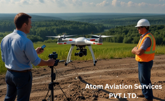
Drone Survey and Mapping: The Future of Precision and Efficiency
Introduction
In recent years, the use of drones has revolutionized various industries, from agriculture to construction, and one of the most impactful applications has been in the field of surveying and mapping. Drone survey and mapping have become essential tools for professionals who require accurate, high-resolution data in a fraction of the time it would take using traditional methods. In this blog, we’ll explore why drone survey and mapping are gaining popularity, how they work, and why they might be the perfect solution for your next project.
What is Drone Survey and Mapping?
Drone survey and mapping involve the use of unmanned aerial vehicles (UAVs) equipped with advanced cameras, sensors, and GPS technology to capture aerial data. This data is then processed using specialized software to create detailed maps, 3D models, and topographic surveys. Unlike traditional surveying methods, drones can cover large areas quickly, safely, and with incredible precision.
Why Choose Drone Survey and Mapping?
Speed and Efficiency Drones can survey vast areas in a matter of minutes or hours, compared to days or weeks with ground-based methods. This speed is particularly beneficial for time-sensitive projects like construction site monitoring or disaster assessment.
Cost-Effective By reducing the need for heavy equipment, manpower, and time, drone surveys significantly cut down on costs. They also minimize the risk of errors, which can be expensive to correct later.
High Accuracy Modern drones are equipped with advanced sensors like LiDAR and photogrammetry cameras, which capture data with centimeter-level accuracy. This makes them ideal for creating detailed topographic maps or 3D models.
Safety Drones can access hard-to-reach or hazardous areas, such as steep slopes, unstable terrain, or disaster zones, without putting human surveyors at risk.
Versatility From agriculture and mining to urban planning and environmental monitoring, drone surveys can be tailored to suit a wide range of industries and applications.
How Does Drone Survey and Mapping Work?
Planning the Flight Before launching a drone, surveyors plan the flight path using specialized software. This ensures complete coverage of the area and optimal data collection.
Data Collection The drone is equipped with cameras and sensors that capture high-resolution images, elevation data, and other relevant information as it flies over the area.
Data Processing The collected data is processed using photogrammetry or LiDAR software to create maps, 3D models, or contour lines. This step often involves stitching together hundreds or thousands of images to form a cohesive model.
Analysis and Reporting The final output is analyzed and presented in a format that meets the project’s requirements, whether it’s a topographic map, volumetric analysis, or a detailed 3D rendering.
Applications of Drone Survey and Mapping
Construction Drones are used to monitor construction progress, track stockpile volumes, and create as-built surveys.
Agriculture Farmers use drone surveys to assess crop health, plan irrigation systems, and optimize land use.
Mining Drones help in calculating stockpile volumes, monitoring mine sites, and ensuring compliance with safety regulations.
Environmental Monitoring Conservationists use drones to map forests, monitor wildlife, and assess the impact of natural disasters.
Urban Planning City planners rely on drone surveys to create detailed maps for infrastructure development and zoning.
Choosing the Right Drone for Survey and Mapping
When selecting a drone for surveying and mapping, consider the following factors:
Payload Capacity: Ensure the drone can carry the necessary cameras and sensors.
Flight Time: Longer flight times allow for larger areas to be covered in a single mission.
GPS Accuracy: High-precision GPS is essential for accurate data collection.
Software Compatibility: The drone should be compatible with industry-standard mapping software.
Popular drones for surveying include the DJI Phantom 4 RTK, senseFly eBee X, and WingtraOne.
The Future of Drone Survey and Mapping
As technology continues to advance, the capabilities of drone survey and mapping are only expected to grow. Innovations like AI-powered data analysis, real-time mapping, and improved battery life will make drones even more efficient and accessible. Additionally, the integration of drones with other technologies, such as augmented reality (AR) and the Internet of Things (IoT), will open up new possibilities for industries worldwide.
Conclusion
Drone survey and mapping have transformed the way we collect and analyze spatial data. With their unmatched speed, accuracy, and versatility, drones are becoming an indispensable tool for professionals across various fields. Whether you’re a land surveyor, a farmer, or a construction manager, incorporating drone technology into your workflow can save time, reduce costs, and improve the quality of your projects.
If you haven’t yet explored the potential of drone survey and mapping, now is the time to take flight. The sky’s the limit when it comes to what you can achieve with this cutting-edge technology!
Call to Action Ready to elevate your surveying and mapping projects? Contact us today to learn more about how drone technology can benefit your business. Let’s map the future together!
#DroneSurvey#AerialMapping#GIS#RemoteSensing#LidarTechnology#Geospatial#TopographicMapping#LandSurvey#UAVMapping#AerialSurvey#3DMapping#SurveyingSolutions#PrecisionMapping#DroneTechnology#MappingInnovation
1 note
·
View note
Text
Unlocking the Power of UAV Mapping with 3DPointshot
In recent years, the field of mapping and surveying has undergone a remarkable transformation, thanks to advancements in UAV technology. UAV mapping, also known as unmanned aerial vehicle mapping, has revolutionized how we capture, analyze, and interpret spatial data. 3DPointshot, a leader in the industry, offers cutting-edge UAV Mapping Systems that provide precise and efficient solutions for a wide range of applications.

What is UAV Mapping?
UAV mapping involves using drones equipped with high-resolution cameras and sensors to capture aerial images and data of the Earth's surface. These images are then processed and transformed into accurate maps and 3D models. This method of mapping is not only cost-effective but also offers unparalleled flexibility and accessibility, making it an invaluable tool for various industries.
Advantages of UAV Mapping
Precision and Accuracy: UAV Mapping Systems by 3DPointshot provide highly accurate data, essential for applications such as construction, agriculture, and urban planning. The detailed maps and models produced by UAV aerial mapping enable professionals to make informed decisions based on reliable data.
Time Efficiency: Traditional mapping methods can be time-consuming and labor-intensive. UAV mapping significantly reduces the time required to collect and process data, allowing for faster project completion and quicker decision-making.
Cost-Effectiveness: UAV aerial mapping reduces the need for expensive manned aircraft and ground surveys. This cost-effective solution makes advanced mapping technology accessible to a broader range of projects and industries.
Safety: UAV mapping minimizes the need for personnel to work in hazardous or hard-to-reach areas. Drones can safely capture data in challenging environments, ensuring the safety of workers while still obtaining accurate information.
Applications of UAV Mapping Systems
The versatility of UAV mapping systems makes them suitable for a wide range of applications. Here are a few examples:
Agriculture: UAV aerial mapping allows farmers to monitor crop health, optimize irrigation, and assess soil conditions. This data-driven approach helps in increasing yield and improving overall farm management.
Construction and Infrastructure: Detailed maps and 3D models generated by UAV mapping systems are invaluable for construction planning, progress monitoring, and site inspections. These tools help in identifying potential issues early and ensuring project accuracy.
Environmental Monitoring: UAV mapping is essential for monitoring natural resources, tracking environmental changes, and assessing the impact of human activities on ecosystems. This information aids in conservation efforts and sustainable development.
Urban Planning: City planners and architects utilize UAV mapping to create detailed urban maps, plan infrastructure, and manage land use. The accurate data provided by UAV aerial mapping supports efficient urban development.
Why Choose 3DPointshot?
3DPointshot stands out in the field of UAV mapping due to its commitment to innovation and quality. Their state-of-the-art UAV Mapping Systems are designed to deliver precise and reliable results, tailored to meet the unique needs of each project. With a team of experienced professionals and a dedication to customer satisfaction, 3DPointshot ensures that clients receive the best possible solutions for their mapping and surveying needs.In conclusion, UAV mapping, with its precision, efficiency, and cost-effectiveness, is transforming how we approach mapping and surveying. 3DPointshot is at the forefront of this revolution, offering advanced UAV Mapping Systems that cater to a wide range of applications. To learn more about their services, visit and discover how UAV aerial mapping can benefit your next project.
0 notes
Text
Drone Manufacturing Company | ideaForge
IdeaForge drones have an ergonomic design and have been tested in extreme weather conditions to high altitudes across India from desserts to glaciers.
1 note
·
View note
Photo

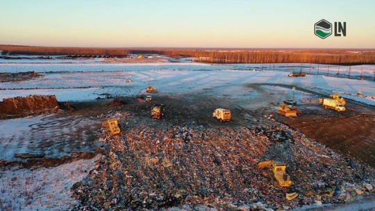
Aerial landfill mapping - Precision/Accuracy/Efficiency/Reliability. Our aerial data capture and data processing solution enable us to deliver imaging data more quickly then ever before @lnaerial #landfill #landfillmapping #aerial #aerialmapping #survey #surveyor #uavphotography #uavservices #uavmapping #ln #lnldt #drone #droneview #fortmac #yeg #acrosscanada #uav #yegbusiness (at Fort mcmurray, alberta) https://www.instagram.com/chrisbernardphotography/p/Bv2lX_PjOK_/?utm_source=ig_tumblr_share&igshid=16d6k30m2bsgs
#landfill#landfillmapping#aerial#aerialmapping#survey#surveyor#uavphotography#uavservices#uavmapping#ln#lnldt#drone#droneview#fortmac#yeg#acrosscanada#uav#yegbusiness
1 note
·
View note
Photo
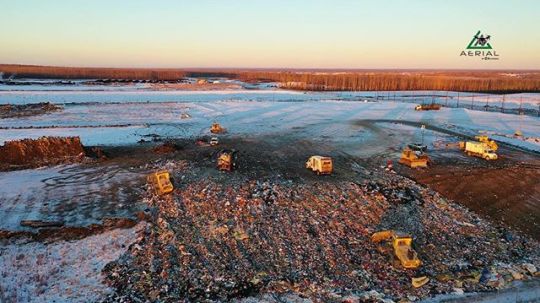
Aerial landfill mapping - Precision/Accuracy/Efficiency/Reliability. Our aerial data capture and data processing solution enable us to deliver imaging data more quickly then ever before @lnaerial www.lnldt.ca #landfill #landfillmapping #aerial #aerialmapping #survey #surveyor #uavphotography #uavservices #uavmapping #ln #lnldt #drone #droneview #fortmac #yeg #acrosscanada #specialservices (at Fort mcmurray, alberta) https://www.instagram.com/p/Bv2kvcslCFa/?utm_source=ig_tumblr_share&igshid=umugasxq6fhl
#landfill#landfillmapping#aerial#aerialmapping#survey#surveyor#uavphotography#uavservices#uavmapping#ln#lnldt#drone#droneview#fortmac#yeg#acrosscanada#specialservices
1 note
·
View note
Text

AR.Drone Parrot 2.0 Elite Edition
#djiglobal#djimavicpro#djispark#dji#djimon hounsou#droneshots#aircraft#drone nerds#dronefly#drone#uavmapping#russian defeat
0 notes
Text
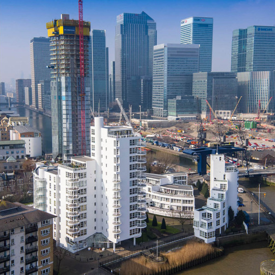
#dronesurvey#drone#dronepilot#dronephotography#surveying#dronesurveyandinspectioninlondon#dronestagram#droneroofinspections#dronephotogrammetry#topografiacondron#dronemapping#dronelife#droneservices#droneoftheday#dronesforgood#uavmapping#dronesaregood#aerialphotography#droneshots#londondrones#londondronesurvey#london#photogrammetry#dronefiliming#dronevideo#highresolutioninspections#drone photography london#film photography#cameras
0 notes
Photo

Infosys ने गुरुवार को कहा कि, mumbai स्थित UAV system manufacturing company ideaForge Technology में $1 मिलियन का निवेश करेगी। Infosys said on Thursday that it will invest $1 million in Mumbai-based UAV systems manufacturing company ideaForge Technology. #infosys #infosysmysore #infosysbangalore #infosyspune #infosyshyderabad #infosyschennai #infosyshydsez #uav #uavpilot #uavphotography #uavdrone #uavexperts #uavsurvey #uavmapping #uavexperts #uavstartup #unmannedaerialvehicle #unmannedaircraft #unmannedsystems #dronestartup #ideaforge #ideaforgetechnology #mayovi #mumbai #mumbaistartup (at Mumbai) https://www.instagram.com/p/CLMy27DnxNT/?igshid=1nadamq9aurty
#infosys#infosysmysore#infosysbangalore#infosyspune#infosyshyderabad#infosyschennai#infosyshydsez#uav#uavpilot#uavphotography#uavdrone#uavexperts#uavsurvey#uavmapping#uavstartup#unmannedaerialvehicle#unmannedaircraft#unmannedsystems#dronestartup#ideaforge#ideaforgetechnology#mayovi#mumbai#mumbaistartup
0 notes
Video
instagram
Testing the big guys reflexes #drones #longrangedrones #uavpilot #uavmapping
0 notes
Photo

This is a snap shot from one of the pages of our Quality report generated from a aerial mapping mission recently flown. It shows Camera Optimization, Overlap coverage, and much more. Also it shows an elevation map which loos a bit like thermal reporting www.lnldt.ca #georeferenced #2d #qualitycontrol #thermoreporting #aerial #aerialmapping #aerialortho #aerialmission #aerialservices #edmontonaerialservices #albertaaerialservices #dronemission #dronemapping #droneview #droneservices #dronepilot #edmontondronepilot #albertadronepilot #lnldt #uav #uavphotography #uavmapping #uavlife #uavtechnology #uavsurvey #edmontonsurvey #aerialsurvey http://bit.ly/2UYqqXl
#georeferenced#qualitycontrol#thermalmapping#thermalreport#aerial#aerialmapping#aerialview#aerialmission#aerialservices#drone#dronepilot#dronemapping#droneservices#edmonton#edmontondrone#edmontondronepilot#edmontondroneservices#edmontondronephotography#albertadrone#albertadronepilot#aerialsurvey#dronesurvey#edmontonsurveyor#droneview#edmontonaerialservices
1 note
·
View note
Video
Do you know anyone who does aerial light shows? Tell ‘em to reach out! Good things are coming 😉🤫 🎥✨ Video credits to @fireflydroneshows ✅Follow us on Tiktok @aironautica and @fireflydroneshows #drone #drones #droneshow #lightshow #dronepilot #security #lighting #engineering #lightprojectionshow #aerial #aeriallightshow #cool #moderntech #entertainment #droneexpo #droneshows #lights #shapes #uav #uavpilot #uavmapping #uavdrones #droneracing #dronestagram #dronelightshow #aironautica (at Florida) https://www.instagram.com/p/CTx0iukrlRg/?utm_medium=tumblr
#drone#drones#droneshow#lightshow#dronepilot#security#lighting#engineering#lightprojectionshow#aerial#aeriallightshow#cool#moderntech#entertainment#droneexpo#droneshows#lights#shapes#uav#uavpilot#uavmapping#uavdrones#droneracing#dronestagram#dronelightshow#aironautica
0 notes
Video
instagram
I’m so proud of you! #carbonfiber_cnc #drones #robotics #dronegram #dronephotography #multirotors #fpvfreestyle #fpvquad #airframes #quad #pilot #unmanned #aerospace #tricoptera #cncowner #cncmachine #carbonfiberparts #uavmapping #hexacopter #rcplanes #tricopters #cncrouter #carbonfiberart #droneracing #uavnews #racetotheedge #hexacopterlikesbatteries https://www.instagram.com/p/CFzim1MHjyo/?igshid=4ikmlbqn3iu3
#carbonfiber_cnc#drones#robotics#dronegram#dronephotography#multirotors#fpvfreestyle#fpvquad#airframes#quad#pilot#unmanned#aerospace#tricoptera#cncowner#cncmachine#carbonfiberparts#uavmapping#hexacopter#rcplanes#tricopters#cncrouter#carbonfiberart#droneracing#uavnews#racetotheedge#hexacopterlikesbatteries
0 notes
Text
Revolutionizing Industries with Drone Surveys

In recent years, drone surveys have transformed how industries gather data, offering unparalleled accuracy, efficiency, and cost-effectiveness. With the growing demand for cutting-edge solutions, finding the best drone survey company in India has become a priority for businesses across sectors.
What is a Drone Survey?
A drone survey leverages unmanned aerial vehicles (UAVs) equipped with advanced sensors and cameras to capture high-resolution data from above. This modern method outperforms traditional surveying techniques by providing:
Enhanced accuracy: Precise data collection for mapping and analysis.
Time efficiency: Surveys completed in a fraction of the time.
Cost savings: Reduced manpower and equipment costs.
Companies like a Lidar survey company in India use drones equipped with Lidar technology to capture detailed 3D models, making them indispensable for complex projects.
Why Choose a Drone Survey Company in India?
India’s drone industry is booming, with a plethora of companies offering state-of-the-art solutions. Opting for a drone survey company in India provides several advantages:
Local expertise: Knowledge of regulations and terrain.
Advanced technology: Access to the latest UAVs and software.
Cost efficiency: Affordable services tailored to regional needs.
By working with the best drone survey company in India, businesses can ensure their projects are completed with precision and compliance.
Applications of Drone Surveys
Drone surveys have revolutionized various industries. Below are some key applications:
Construction:
Site analysis and progress monitoring.
Creating accurate 3D models and topographic maps.
Agriculture:
Crop health monitoring and yield estimation.
Precision farming techniques.
Mining:
Volume calculations and resource mapping.
Enhancing safety by minimizing human intervention.
Real Estate:
Aerial views for marketing and property analysis.
Site feasibility studies.
Infrastructure Development:
Highway and railway surveys.
Bridge inspections and urban planning.
These use cases highlight why partnering with the best drone survey company in India is essential for businesses aiming to stay ahead.
Lidar Survey vs. Traditional Methods
A Lidar survey employs laser technology to create highly accurate 3D maps, surpassing traditional methods in speed and precision. Benefits of choosing a Lidar survey company in India include:
Detailed Mapping: Capture minute details with pinpoint accuracy.
Time Efficiency: Complete large-scale surveys quickly.
Versatility: Ideal for various terrains and environmental conditions.
How to Choose the Best Drone Survey Company in India
Finding the right partner for your project is crucial. Consider these factors when selecting a drone survey company in India:
Experience: Years of expertise in drone technology and survey solutions.
Technology: Access to advanced UAVs, Lidar systems, and software.
Client Reviews: Positive testimonials and a strong portfolio.
Compliance: Adherence to government regulations and safety standards.
Choosing the best drone survey company in India ensures successful project outcomes, saving time and resources.
Conclusion
The era of drone surveys is here, offering unmatched accuracy and efficiency across industries. By partnering with a reliable drone survey company in India, businesses can unlock the potential of cutting-edge technology and achieve their goals seamlessly.
Ready to take your project to the next level? Contact the best drone survey company in India today and experience the future of surveying!
#DroneSurvey#UAVSurveying#AerialSurveying#DroneMapping#SurveyingWithDrones#DronesInConstruction#DroneTechnology#AerialSurvey#UAVTechnology#GeospatialData#RemoteSensing#DronesForSurveying#ConstructionSurveying#DroneInspection#MappingWithDrones#SurveyingInnovation#DroneSurveyingServices#UAVMapping#AerialDataCollection
1 note
·
View note
Text
https://geopasi.com
▪︎082215152011▪︎
Jasa Survey Pemetaan / Land Survey / Survey hidrografi, Jasa Pengukuran Tanah, Jasa Pemetaan & Topografi. Asbuilt Survey.
Perusahaan Jasa Survey Pemetaan,
Jasa Survey Konstruksi:
Setting out
Setting as Bangunan
Setting Request Level
Topografi detail, Pemantauan Konstruksi, Monitoring konstruksi, pelaporan, Asbuilt.
Jasa pengukuran lahan Luas Menggunakan Drone / Pemetaan Drone Fix Wings.
Drone! Aerial Mapping survey
#Surveyservices.
#Onshore #offshore #Miningsurvey #shoreline #perencanaan #konsultanjasasurveypemetaan #konstruksi #Surveylidar #surveyengineering #Jasaukurtanah #pengukurantanah #topografipantai #pemeruman #dermaga #port #Uavmapping #CadGIS #Hydrographic #harbour #GEOPASI #geopasisurvey #Jasasurveyindonesia #Jasasurveytopografi #JasaSurveyor
0 notes
Text
Aerial landfill mapping - Precision/Accuracy/Efficiency/Reliability. Our aerial data capture and data processing solution enable us to deliver imaging data more quickly then ever before @lnaerial #landfill #landfillmapping #aerial #aerialmapping #survey #surveyor #uavphotography #uavservices #uavmapping #ln #lnldt #drone #droneview #fortmac #yeg #acrosscanada #uav #yegbusiness
via Instagram https://ift.tt/2FR00NI
0 notes
Photo

Auzel Consulting is proud to announce a well-deserved congratulations to Famindo Inovasi Teknologi for successfully implementing and maintaining their Quality Management System requirements – ISO 9001:2015. Our compliments to the entire team on their combined efforts. Great Job. Keep it up. The Famindo Inovasi Teknologi company is the FIRST and THE ONLY ONE of Unmanned Aerial Vehicles (#UAVs) technology manufacturer in Southeast Asia located at Sentul, West Java Indonesia. The benefits of using an Unmanned Aerial Vehicles or Drone technology are improved #health and #safety, #quality data ( #accuracy & #precision #data #analysis), #timely and significant #cost #savings. The business core of Famindo Inovasi Teknologi are: 1. Manufacturer of UAV 2. Drone Pilot School / Training 3. Inspections and Surveys a. Infrastructure & Land Survey (i.e. #Land #Survey for #Agriculture / #palmoil, #Viaduct & #Bridges, #Structural, #Thermal, #confinedspace). b. Power Generation, Transmission and Distribution (i.e. #Powerline, Wind Turbine Blades, #Offshore Substations & Met Masts, #Chimney & Cooling #Towers, #Nuclear). c. Oil, Gas and Petrochemical (i.e. #Flare stacks, Offshore Underdeck and #risers, #tank, #tanker, #FPSO, #Onshore Storage Tanks, Contact NDT, Monitor Leaks in #pipeline #infrastructure). For all your Unmanned Aerial Vehicle needs, please do not hesitate to get in contact [email protected];[email protected] or visit us athttps://www.famindoinovasiteknologi.com/ #unmannedaerialvehicles #uavsurveillance #uavagriculture #uavsurvey #uavphotography #uavpilot #uavmapping #uavexperts #uavfutures #uavdrone #uavinspections #uavindonesia #uavtraining #uavpilots #uavcompany #drone #uavsurveys #uas #mappingsurveys #buildingsurveys #constructionsurveys #agriculture #oilandgas #palmoil #windturbineblades #petrochemical #mining #inspections #storagetank #vessel #confinedspace #epc #ndt #risers #leaks #pilot #training #school #southeastasia #asia #indonesia #technology #innovation #famindoinovasiteknologi #famindo #karyaanakbangsa #karyaanakbangsaindonesia #qualitymanagementsystem #iso90012015 (at PT. Famindo Inovasi Teknologi) https://www.instagram.com/p/BvBxaS1neNo/?utm_source=ig_tumblr_share&igshid=rwzm7bfp2lqs
#uavs#health#safety#quality#accuracy#precision#data#analysis#timely#cost#savings#land#survey#agriculture#palmoil#viaduct#bridges#structural#thermal#confinedspace#powerline#offshore#chimney#towers#nuclear#flare#risers#tank#tanker#fpso
0 notes