#uinta mountains
Explore tagged Tumblr posts
Visit Tumblr Blog
Explore Tumblr blogs with no restrictions, modern design and the best experience.
Last Seen Tumblr Blogs


Fun Fact
Tumblr’s reach among the 26-to-35-year-olds in the US is 11%.
Text


Forest (No. 68)
Wasatch County, UT (two pics)
Fruitland, UT (eight pics)
Douglas Pass View Point, CO (two pics)
#USA#travel#original photography#vacation#tourist attraction#landmark#landscape#countryside#mountains#summer 2022#forest#woods#flora#nature#Wasatch County#Utah#Uinta Mountains#blue sky#clouds#meadow#Fruitland#Douglas Pass View Point#Douglas Pass#Colorado
12 notes
·
View notes
Text

View of the Uinta Mountains, from Lonetree, Wyoming, June 7, 2024 https://midwesternartlovertraveler.tumblr.com/
5 notes
·
View notes
Text


Instagram
#stay and wander#walk in the woods#woods#woodlands#woodland#forest#forest lovers#in the mountains#forestscape#dreamy light#nature walk#beautiful landscape#landscape photography#landscape scenery#utah#uintas#adventure#camping#tree lovers
658 notes
·
View notes
Text


Winter Sunset in the Canyon, Utah.
#photography#nature#nikon#landscape#original#photographers on tumblr#travel#art#mountains#utah#america#hikers#backpackers#wasatch#uintas#sunset#sky#sunrise
29 notes
·
View notes
Text
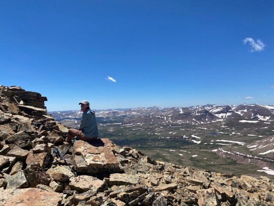


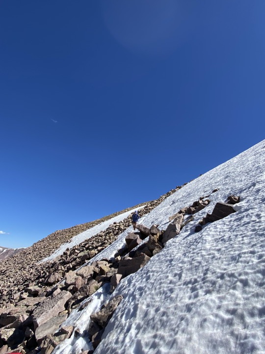
King’s Peak (again)
25.0 mile roundtrip
4,202 feet elevation gain
Link: https://www.alltrails.com/trail/us/utah/kings-peak-utah-highpoint-trail
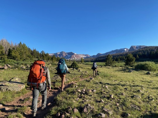
Back again in the High Uintas, but this time with friends! I was joined on this trip by Emily, Kenny, and Chris, with Nick, Eliza, and Brady meeting us on our second day.
We got to the trailhead in the early afternoon with the goal of setting up camp at Dollar Lake, roughly 7 miles in. The hike in was, of course, absolutely gorgeous. We saw so few people on the trail and had a great time playing Contact to keep morale up. 7 miles with a heavy pack is no joke, but everyone in our party absolutely killed it. We also talked to some people who said they saw a bear, so I was pretty happy with my choice to keep bear spray clipped to my pack. It’s surprising to hear of a bear sighting at this high of an altitude, though.
At one point we came upon a trail sign with somebody’s phone and backpack just sitting there. I thought it would be funny to take a couple selfies on the phone and leave it there, and we learned on the way off the trail that the phone belonged to someone who had broken their leg and gotten evacuated. WHOOPS! Gotta wonder why they didn’t take the person’s stuff with them too, but at least now they can look at our beautiful faces while they’re in bed recovering.
We made it to Dollar Lak just as the sun was setting and the bugs were coming out. We quickly ate dinner, pumped water at the lake, hung our food in a tree, and hit the hay for an early morning.
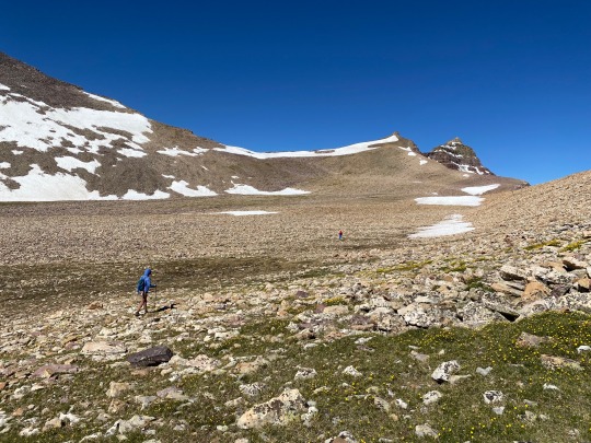
Chris decided to sit out the summit push because his back was hurting, so Emily, Kenny, and I set out just the three of us. The hike turned into a slog and a bit of a game of map interpretation – I know we wanted to hit Gunsight Pass as a shortcut, but we were having some trouble physically locating it. Luckily we were able to get some directions by another guy on the trail, because where I thought Gunsight Pass was located was not even close to where it actually was.
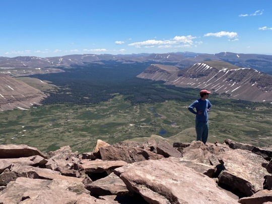
The pass, when we found it finally, was a tough uphill through the snow with lots of postholing. Then it opens up into this HUGE basin to cross before the final uphill to the summit. We pretty much just put our heads down and hiked, crossing the enormous rocks in the basin and aiming generally for the saddle that indicated the start of the final climb, official trail be damned (because we literally couldn’t find it).
With a final scramble up the ridge, we eventually made it to the summit, and suddenly every ache and pain was worth it. We had the whole summit to ourselves for about 30 minutes. Stupendous. We hung out, snapped some pics, ate some Snickers, and then started our long haul back down.
Fueled by Nuun to prevent the bonk, we really only ran into trouble when we got back to Gunsight Pass. From above, it looked like a totally alien world from what we saw earlier. The snow had softened a ton, the path looked even steeper, and we were tired. After some deliberation, we chose the “safest” path and pretty much had to downclimb the whole way. It was definitely spooky and exposed, and I’m really proud of how the three of us maintained our composure the whole way. The joy of adventure, the butt-puckering of navigating a steep snowfield with crazy exposure… what a combo.
After the pass it was just a straight shot back to camp. Being back in the valley with sweeping views of the surrounding mountains and alpine lakes, there are so few words to describe it. I was filled with such a sense of peace and awareness that I can really only achieve when in remote wilderness. And chasing those feelings is what keeps me coming back to places like this. What a world we live in.
Back at camp, we met back up with Chris and were delighted to see that Nick, Eliza, and Brady were able to find us. After a long day of hiking, it was so nice to chill out by a campfire for the evening and kick it with our homies.
The next morning we had a quick breakfast and packed up camp to hike out. Before leaving, though, we decided to finally see for ourselves what it’s like to spray bear spray. We all took turns with it, and I have to say I was surprised by how short the range was… It only goes about 5ish yards, so you’re not hitting the bear until it’s up in your grill. Pretty scary to imagine the situation I’m in when I need to use the spray.
The hike out was a bit of a grind, especially after how exhausting the summit push was the day before. I’ve said it before and I’ll say it again, there’s almost nothing better than that first sight of the car after a long, long hike. Those hunks of metal are the equivalent to angels in those moments.
And that was that! We got up and down safely, and that’s all that really matters. I’m hoping next year we can do more of these trips with friends, and I’m thankful to have the homies that get just as excited as I do to suffer in the backcountry.
0 notes
Text
Take me back. June, hopefully 🙏🏼✨

High Uinta’s Wilderness, UT by Ryan Jorgensen
#utah#landscape#nature#hiking#mountains#wanderlust#river#sunset#fishing#outdoors#uintas#wilderness#northern Utah
85 notes
·
View notes
Text

Uinta Mountains from the Mirror Lake Scenic Byway, Utah, USA
420 notes
·
View notes
Text


A little adventure into the mountains a few days ago. All five of us enjoyed ourselves a lot. The Uintas are gorgeous!
#australian shepherd#dogblr#aayla#dog#aussie#adventure dog#dog training#hiking dog#ryker#rebel#adventure cat#hiking cat#hiking#trails#mountains#utah#why does tumblr ruin the quality??
26 notes
·
View notes
Text


Forest (No. 67)
Wasatch County, UT
#USA#travel#original photography#vacation#tourist attraction#landmark#landscape#countryside#mountains#summer 2022#forest#woods#flora#nature#Wasatch County#Utah#Uinta Mountains#blue sky#clouds#meadow
6 notes
·
View notes
Note
If a zombie apocalypse occurred, what place would you use as your base?
Probably one of the now closed Boy Scout camps in the Uinta range of the Rocky Mountains. It's remote enough that few zombies would get there, should be easy enough to convert into a stronghold, and is a pleasant place to wait out the the initial outbreak. All the zombies should be dead after 6ish months, so I'll return once that is over to see how things have settled.
Also, wear all denim clothes. The human jaw strength can't get through denim, so that should be adequate armor.
Thanks!
8 notes
·
View notes
Text
U.S. daily precipitation records tied/broken 1/2/2025
Arapahoe National Forest, Colorado: 0.6" (previous record 0.5" 2003) Chalk Mt. summit, Colorado: 0.4" (also 0.4" 2004) Copper Mt. summit, Colorado: 0.4" (also 0.4" 1994) Fraser, Colorado: 0.38" (previous record 0.28" 2004) Georgetown, Colorado: 0.21" (previous record 0.14" 1959) Hoosier Pass summit, Colorado: 0.5" (previous record 0.3" 2004) James Peak Wilderness, Colorado: 0.6" (also 0.6" 2004) Rocky Mountain National Park, Colorado: 0.5" (also 0.5" 2011) San Isabel National Forest, Colorado: 0.4" (previous record 0.3" 1994) Atlanta Peak summit, Idaho: 0.9" (previous record 0.8" 1998) Banner Pass summit, Idaho: 1.1" (previous record 0.9" 1998) Big Creek Pass summit, Idaho: 0.9" (previous record 0.7" 1994) Bitterroot National Forest, Idaho: 0.9" (previous record 0.5" 1997) Boise National Forest, Idaho: 1.3" (previous record 0.9" 1997) Galena Pass summit, Idaho: 0.7" (previous record 0.5" 2006) Magic Mt. summit, Idaho: 0.7" (previous record 0.5" 2009) Payette National Forest, Idaho: 1.4" (previous record 1.2" 2003) Salmon National Forest, Idaho: 0.4" (also 0.4" 2009) Sawtooth National Forest, Idaho: 1" (previous record 0.9" 1997) Secesh Peak summit, Idaho: 0.7" (also 0.7" 2009) Wallowa National Forest, Idaho: 0.8" (previous record 0.6" 2003) Rock Island, Illinois: 1.8" (previous record 1.18" 1873) Baker, Louisiana: 1.66" (previous record 1.57" 1996) Corinna, Maine: 1.1" (previous record 1.03" 1987) Rockport, Maine: 1.6" (previous record 1.05" 1982) Rifle River State Recreation Area, Michigan: 1" (previous record 0.56" 1965) Beaverhead National Forest, Montana: 0.3" (also 0.3" 2009) Bitterroot National Forest, Montana: 0.4" (also 0.4" 2020) Custer National Forest, Montana: 0.6" (also 0.6" 2009) Lewis & Clark National Forest, Montana: 0.4" (also 0.4" 1996) Unincorporated Summit County, Utah: 0.4" (also 0.4" 2017) Uinta National Forest, Utah: 0.5" (also 0.5" 2006) Bighorn National Forest, Wyoming: 0.3" (previous record 0.2" 2018) Custer National Forest, Wyoming: 0.3" (also 0.3" 2009) Medicine Bow National Forest, Wyoming: 0.6" (also 0.6" 2004) Parker Peak summit, Wyoming: 0.7" (previous record 0.5" 2009) Shoshone National Forest, Wyoming: 0.4" (also 0.4" 1998) Unincorporated Sublette County, Wyoming: 0.35" (previous record 0.32" 2023) Wind River Reservation, Wyoming: 0.3" (also 0.3" 2006) Yellowstone National Park, Wyoming: 0.6" (previous record 0.5" 1993)
#Storms#U.S.A.#U.S.#Colorado#1990s#1950s#Idaho#Illinois#1870s#Louisiana#Maine#1980s#Michigan#1960s#Montana#Utah#Wyoming#Crazy Things#Awesome
2 notes
·
View notes
Text
Excerpt from this story from Mother Jones:
The state of Utah has come up with its share of boondoggles over the years, but one of the more enduring is the Uinta Basin Railway. The proposed 88-mile rail line would link the oil fields of the remote Uinta Basin region of eastern Utah to national rail lines so that up to 350,000 barrels of waxy crude oil could be transported to refineries on the Gulf Coast. The railway would allow oil companies to quadruple production in the basin and would be the biggest rail infrastructure project the US has seen since the 1970s.
But in all likelihood, the Uinta Basin Railway will never get built. The Uinta Basin is hemmed in by the soaring peaks of the Wasatch Mountains to the west and the Uinta Mountains to the north. Running an oil train through the mountains would be both dangerous and exorbitantly expensive, especially as the world is trying to scale back the use of fossil fuels. That’s why the railway’s indefatigable promoters, including the state’s congressional delegation, will probably fail to get the train on the tracks. However, they have succeeded in one thing: providing an activist Supreme Court the opportunity to take a whack at the National Environmental Policy Act (NEPA), one of the nation’s oldest environmental laws.
Enacted in 1970, NEPA requires federal agencies to consider the environmental and public health effects of such things as highway construction, oil drilling, and pipeline construction on public land. Big polluting industries, particularly oil and gas companies, hate NEPA for giving the public a vehicle to obstruct dirty development projects. They’ve been trying to undermine it for years, including during the last Trump administration.
Last week, when the Supreme Court heard oral arguments in Seven County Infrastructure Coalition v. Eagle County, former Solicitor General Paul Clement channeled those corporate complaints when he told the justices that NEPA “is designed to inform government decision-making, not paralyze it.” The statute, he argued, had become a “roadblock,” obstructing the railway and other worthy infrastructure projects through excessive environmental analysis. “NEPA is adding a juicy litigation target for project opponents,” Clement told the court.
But NEPA has almost nothing to do with why the Uinta Basin Railway won’t get built. “The court is doing the dirty work for all of these industries that are interested in changing our environmental laws,” Sam Sankar, a senior vice president at Earthjustice, said in a press briefing on the case, noting that Congress already had streamlined the NEPA process last year. Earthjustice is representing environmental groups that are parties in the case. “The fact that the court took this case means that it’s just issuing policy decisions from the bench, not deciding cases.”
The idea of building a railway from the Uinta Basin to refineries in Salt Lake City or elsewhere has been kicking around for more than 25 years. As I explained in 2022, the basin is home to Utah’s largest, though still modest, oil and gas fields:
Locked inside the basin’s sandstone layers are anywhere between 50 and 321 billion barrels of conventional oil, plus an estimated 14 to 15 billion barrels of tar sands, the largest such reserves in the US. The basin also lies atop a massive geological marvel known as the Green River Formation that stretches into Colorado and Wyoming and contains an estimated 3 trillion barrels of oil shale. In 2012, the US Government Accountability Office reported to Congress that if even half of the formation’s unconventional oil was recoverable, it would “be equal to the entire world’s proven oil reserves.”
Wildcat speculators, big oil companies, and state officials alike have been salivating over the Uinta Basin’s rich oil deposits for years, yet they’ve never been able to fully exploit them. The oil in the basin is a waxy crude that must be heated to 115 degrees to remain liquid, a problem that ruled out an earlier attempt to build a pipeline. The Seven County Infrastructure Coalition, a quasi-governmental organization consisting of the major oil-, gas-, and coal-producing counties in Utah, has received $28 million in public funding to plan and promote the railway as a way around this obstacle. The coalition is one of the petitioners in the Supreme Court case.
“We don’t have a freeway into the Uinta Basin,” Mike McKee, the coalition’s former executive director, told me back in 2022. “It’s just that we have high mountains around us, so it’s been challenging.”
Of course, there is no major highway from the basin for the same reason that the railway has never been built: The current two-lane road from Salt Lake City crests a peak that’s almost 10,000 feet above sea level, which is too high for a train to go over. So the current railway plan calls for tunneling through the mountain. But going through it may be just as treacherous as going over it. Inside the unstable mountain rock are pockets of explosive methane and other gases, not all of which have been mapped.
None of this deterred the Seven County coalition from notifying the federal Surface Transportation Board (STB) in 2019 that it intended to apply for a permit for the railway. The following year, the board started the environmental review process, including taking comments from the public.
In December 2021, the STB found that the railway’s transportation merits outweighed its significant environmental effects. It approved the railway, despite noting that the hazards from tunneling “could potentially cause injury or death,” both in the railway’s construction and operation. It recommended that the coalition conduct some geoengineering studies, which it had not done.
3 notes
·
View notes
Video

flickr
I Am Feeling So Great to be Back in the Mountains! by Mark Stevens Via Flickr: A setting looking to the south while taking in views across a mountainside and forest. This is at a roadside pullout along the Alpine Loop Scenic Backway in Uinta-Wasatch-Cache National Forest. My thought on composing this image was to use the side of Mount Timpanogos and have that frame a setting for a look to the more distant peaks and ridges. I also felt that the different hues of yellows and greens in this forest added a layered look, leading a viewer further into the image.
#Along Roadside#Alpine Loop Drive#Alpine Loop Scenic Backway#Aspen#Aspen Leaves#Aspen Trees#Aspens#Azimuth 158.80#Blue Skies with Clouds#Central Wasatch Range#Day 8#DxO PhotoLab 5 Edited#Evergreen Trees#Evergreens#Forest#Forest Landscape#Hillside of Trees#Landscape#Landscape - Scenery#Looking South#Mount Timpanogos#Mountain Landscape#Mountain Peak#Mountains#Mountains in Distance#Mountains off in Distance#Mountainside#Nature#Nikon D850#No People
4 notes
·
View notes
Text
🌟 Outfit of the Day Alert! 🌟
Hey, fashion lovers! 💖 I just snagged the most gorgeous outfit and I couldn’t wait to share it with you all! 🎉✨
I’m absolutely obsessed with this fit! 🎨 It's perfect for transitioning from a casual coffee date to a night out! ☕️➡️🌙
The pants gives me that perfect hourglass shape, while the statement top adds just the right amount of edge to the look. 👗And let’s not forget that I’m currently in the Uinta Mountains! 💫
Let me know in the comments what you think! 💬✨
Stay fabulous, everyone! 💕

2 notes
·
View notes
Text
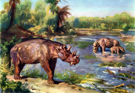
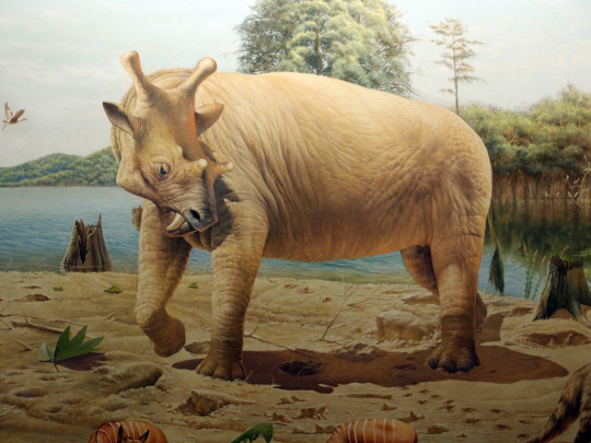
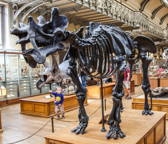
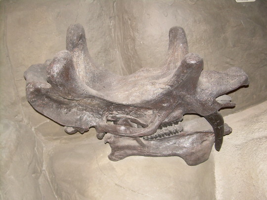
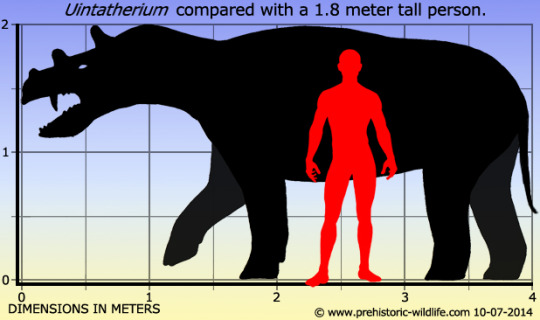
Uintatherium
(temporal range: 56-34mio. years ago)
[text from the Wikipedia article, see also link above]
Uintatherium ("Beast of the Uinta Mountains") is an extinct genus of herbivorous mammal that lived during the Eocene epoch. Two species are currently recognized: U. anceps from the United States during the Early to Middle Eocene (56–38 million years ago) and U. insperatus of Middle to Late Eocene (48–34 million years ago) China.
17 notes
·
View notes
Text
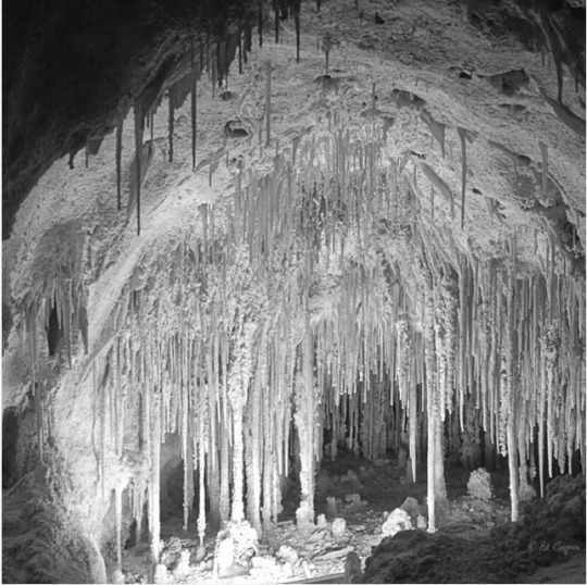

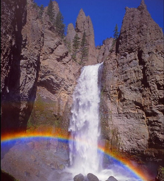


Photos and texts: @ed_cooper_photography
1-. Here we see the slightly creepy and surreal Dolls Theater formation, in Big Room Cave, Carlsbad Caverns NAtional Park. New Mexico. Image taken Feb. 1975!
2-. Here we seen sunrise on El Morro, rising about 60m, above the valley floor, located in El Morro National Monument, New Mexico
3-. Tower fall, 40m., with a rainbow, in the northeast part of Yellowstone National Park, Wyoming. This waterfall is in the Absaroka Mountain Range and feeds the Yellowstone River
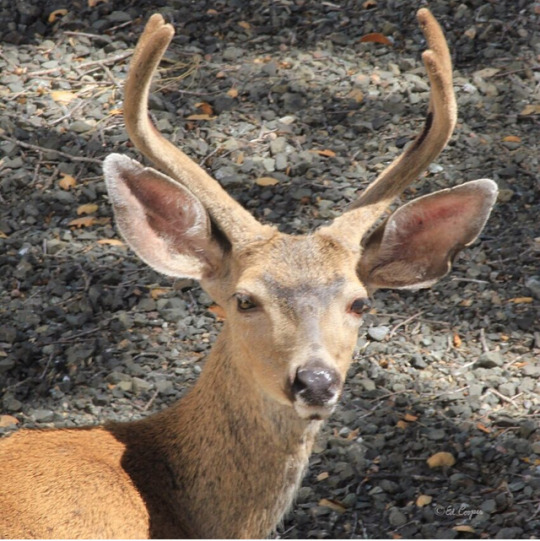
4-. Here we see a mule deer, Odocoileus hemionus, taken yesterday right next to our home here on Sonoma Mountain, California, in the Cooper Biological Preserve
5-. A Confederate wall carving by Augustus Lukeman of, left to right, Jefferson davis, Robert E. Lee & Stonewall Jackson on Stone Mountain, Georgia
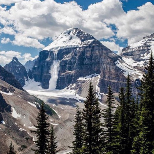
6-. Canadian Rockies
7-. El Morro Nat. Monument. New Mexico
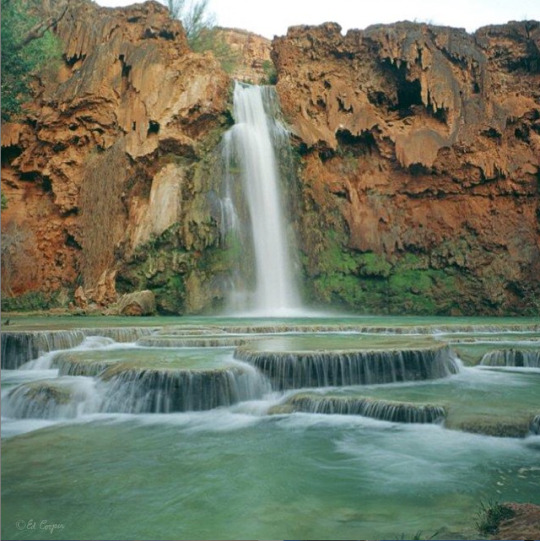
8-. Havasu Falls, in the Havasupai Indian reservation, in the Grand Canyon (but not in the national park)
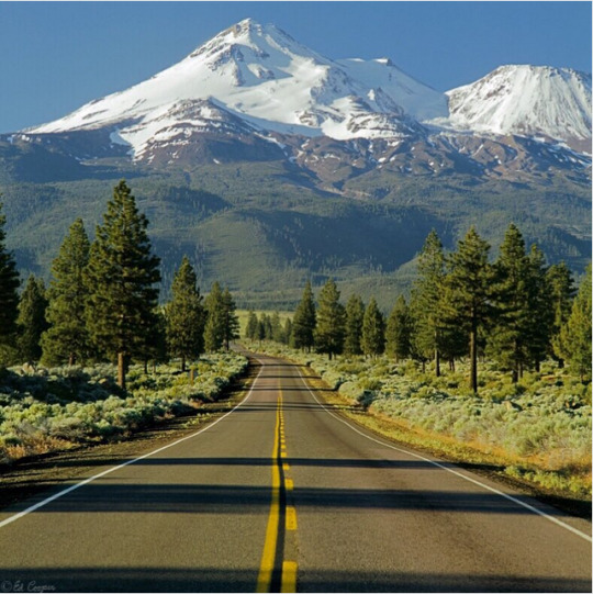
9-. Here we see a road leading us to Mt. Shasta (4317m.), in the northern part of California
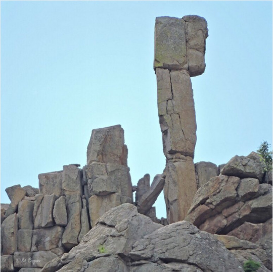
10-. Here we see a rock pinnacle in the Cimarron Palisades, Cimarron Canyon State Park, New Mexico
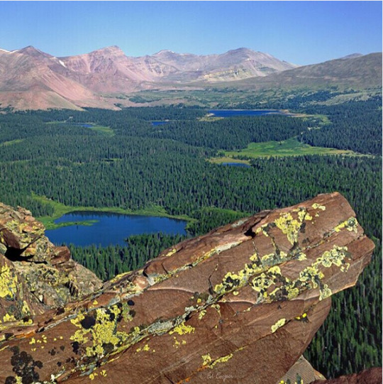
11-. Here we see King's Peak, 4123m., the highest peak in the state of Utah, in the high pristine Uintas Wilderness Area
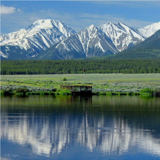
12-. Here we see Mt. Hope (4217m), reflected in a pond in Arkansas Headwaters Recreation Area, Colorado (13-6-2014)
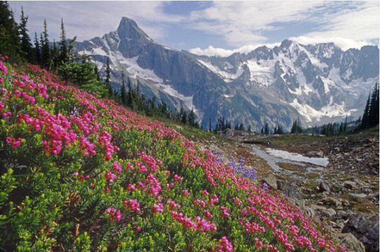
13-. Here we see Pink Mountain Heather, in the Northern Picket Range, of North Cascades Nationa Park, Washington
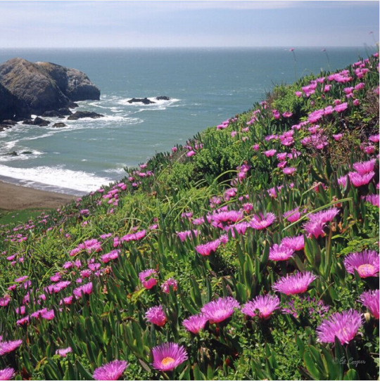
14-. Here we see Rodeo Beach with Sea Fig Ice Plant in the foreground, in the Marin Headlands, Golden Gate National Recreation Area, just north of San Francisco, California
15-. Here we see the amazing Valley of Ten Peaks, in Banff National Park, Alberta, Canada
16-. Here we see the China Wall formation in Slaughter Canyon Cave (new cave) in Carlsbad Caverns National Park. New Mexico - Feb. 1975
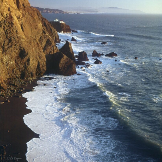
17-. Here we see the lighthouse and Black Sand Beach at Point Bonita, in the Marin Headlands, Golden Gate National Recreation Area, just north of San Francisco, California
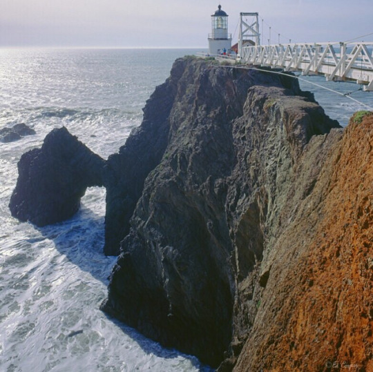
18-. Here we see the lighthouse and natural rock arch at Point Bonita, in the Marin Headlands, Golden Gate National Recreation Area, just north of San Francisco, California
2 notes
·
View notes