#whatcom pass
Explore tagged Tumblr posts
Visit Tumblr Blog
Explore Tumblr blogs with no restrictions, modern design and the best experience.
Last Seen Tumblr Blogs


Fun Fact
Tumblr has 4 main sources of revenue.
Photo

Report generated at 2024-11-20 15:09:32.942752-08:00 using satellite imagery and alert data provided by the National Weather Service.
Wind Advisory
Northeast Foothills/Sacramento Valley
Northern Lake County
Sonoma Coastal Range
Central Sacramento Valley
North Bay Interior Valleys
North Bay Interior Mountains
Mineral and Southern Lyon Counties
Mendocino Coast
Greater Reno-Carson City-Minden Area
Marin Coastal Range
Foothills of the Northern Blue Mountains of Oregon
Northern Sacramento Valley
Southern Lake County
Coastal North Bay Including Point Reyes National Seashore
San Francisco Bay Shoreline
Mono
San Francisco Peninsula Coast
San Francisco
Flood Watch
WA: Mason
Northern Lake County
Northwestern Mendocino Interior
Central Sacramento Valley
North Bay Interior Valleys
Del Norte Interior
Mountains Southwestern Shasta County to Western Colusa County
Shasta Lake Area / Northern Shasta County
Southern Trinity
Coastal Del Norte
Northeast Foothills/Sacramento Valley
Southwestern Mendocino Interior
Northern Humboldt Interior
North Bay Interior Mountains
Southwestern Humboldt
Sonoma Coastal Range
Southeastern Mendocino Interior
South Central Oregon Coast
Southern Lake County
Coastal North Bay Including Point Reyes National Seashore
Northern Humboldt Coast
Southern Humboldt Interior
Northeastern Mendocino Interior
Mendocino Coast
Marin Coastal Range
Northern Sacramento Valley
Winter Storm Warning
Sun Valley Region
Burney Basin / Eastern Shasta County
Western Siskiyou County
Western Plumas County/Lassen Park
North Central and Southeast Siskiyou County
West Slope Northern Sierra Nevada
Mountains Southwestern Shasta County to Western Colusa County
Sawtooth/Stanley Basin
South Central Siskiyou County
Shasta Lake Area / Northern Shasta County
Big Lost Highlands/Copper Basin
Okanogan Highlands
Northern Trinity
Northern and Eastern Klamath County and Western Lake County
Central Siskiyou County
South Central Oregon Cascades
Siskiyou Mountains and Southern Oregon Cascades
Winter Weather Advisory
North Oregon Cascades
Northern and Eastern Klamath County and Western Lake County
Central Panhandle Mountains
Northern Panhandle
Cascades of Lane County
Klamath Basin
East Slopes of the Oregon Cascades
West Central Mountains
Boise Mountains
Cascades of Marion and Linn Counties
West Slopes North Cascades and Passes
Northeast Mountains
Modoc County
Lassen-Eastern Plumas-Eastern Sierra Counties
High Wind Watch
Coastal Del Norte
Southern Humboldt Interior
Northern Humboldt Interior
Del Norte Interior
South Central Oregon Coast
Curry County Coast
Northern Humboldt Coast
Southwestern Humboldt
Flood Advisory
CA: Sierra, Lassen, Sonoma, Napa, Plumas
High Wind Warning
Central and Eastern Lake County
Northeast Siskiyou and Northwest Modoc Counties
Klamath Basin
Northern and Eastern Klamath County and Western Lake County
Central Siskiyou County
Modoc County
High Surf Advisory
Tillamook County Coast
San Luis Obispo County Beaches
Central Coast of Oregon
South Washington Coast
Santa Barbara County Central Coast Beaches
Central Coast
Clatsop County Coast
Coastal North Bay Including Point Reyes National Seashore
San Francisco Peninsula Coast
North Coast
San Francisco
Southern Monterey Bay and Big Sur Coast
Beach Hazards Statement
Northern Monterey Bay
Flood Warning
CA: Siskiyou
OR: Curry, Coos, Josephine, Jackson
Coastal Flood Advisory
Western Whatcom County
San Juan County
Lake Wind Advisory
Greater Lake Tahoe Area
Red Flag Warning
Lahontan Basin - Churchill and Eastern Mineral Counties
Southern Mono County
Southern Sierra Front - Alpine/Northern Mono/Southern Lyon/Western Mineral Counties
West Humboldt Basin - Pershing County
Northern Sierra Front - Carson City/Douglas/Storey/Southern Washoe/Eastern Lyon/Far Southern Lassen Counties
High Surf Warning
South Central Oregon Coast
Curry County Coast
Avalanche Warning
South Central Siskiyou County
6 notes
·
View notes
Text

Welcome to North Cascades Photography
Each week we will visit some place in the North Cascades. The best camp sites; day hikes and overnight trips; lookout towers, the best locations for sunrises, sunsets and night sky imaging. Whether you’re into a week long trip, or the best place for a drive-in view, I will cover the best times to go and How To Tips ranging from How to set exposure for a shot of the Milky Way to Where to see Mountain Goats?
Introduction
My fascination with the North Cascades started with a map.
In 1976 one of my friends read the Nat Geo article about a through hiker on the PCT. Several of us had recently finished a month long Outward Bound program in the Sawtooths, backpacking and rock climbing and we were excited for a new adventure.
I still have the map, from 1976
A few glances at the images and I was sending away for maps. When they finally arrived in the mail I poured over them, tracing the PCT and looking at the terrain.
Pacific Crest Trail, Pasayten Wilderness
It was the first time I’d heard of places like the Pasayten Wilderness and Crater Lake. At that time there was little to read about the trail, most of the planning for a thru hike was up to you.
When you study a map, planning mileage, elevation gain and water sources you try to envision the place. There were more then 20 maps for Washington and Oregon I sorted through, tracing the PCT and making plans. The place I was most captivated with, the most excited about visiting was the North Cascades. I wanted to see the Picket Range and hike over Whatcom Pass.
Mt Adams and Pacific Crest Trail, Goat Rocks Wilderness
First of all, it was clearly the most rugged section. There were other sections with higher summits, like Mt Rainier and Mt Adams.
But these giant peaks were surrounded by much smaller mountains. The North Cascades boasted the greatest density of topographical map lines. I imagined wave after wave of serrated ridges; steep U-shaped valleys, cloaked in green and mantled with glaciers. The names of the places fueled my imagination: Mount Terror and Mount Fury, Desolation Peak, Diablo Lake and Forbidden Peak were just a few. I couldn’t wait to get there. The only problem was that it wasn’t the easiest place to get to!
Sunset at Sahale Camp, North Cascades National Park
In the end we decided to hike the PCT through Oregon. We hitchhiked from eastern Pennsylvania to Cascade Locks, Oregon, along the Columbia River and started our journey south.
My travels led me to many places, decades passed. But the allure and wonder of this place I’d never seen stuck with me.
The Picket Range, from Copper Ridge
Mt Challenger, from Whatcom Pass
Easy Pass, Whatcom Peak and Mt Challenger
Salmon in the Chilliwack River
Sahale Camp
It was 30 years before I made it back to see the places I’d dreamed of: Copper Ridge and the Chilliwack River, Mt Challenger and the Pickets…
I feel privileged to be able to see such things and humbled trying to capture some part of it in an image.
Now I live along the North Cascades Highway. Living on the doorstep of the mountains makes it easy to visit often. I truly feel at home.
Each week North Cascades Photography will visit some place in the North Cascades and share info on the best trails, camp sites, day hikes, long hikes, drive-in vistas, locations for Night Sky imaging and of course lots and lots of images.
You can always find out more about Trips, Classes, Photo Tours and more at my web site, AndyPorterImages.com
Next: The North Cascades Highway

Welcome to the North Cascades
North Cascades Photography – Introduction Welcome to North Cascades Photography
#chilliwack river#copper ridge#mt challenger#North Cascades#north cascades highway#north cascades national park#picket range#whatcom pass
15 notes
·
View notes
Text
Bear Mountain Attempt via Whatcom Pass High Route, North Cascades
The high route above Whatcom Pass has been on Jim and my list since we met. Neither of us had ever been in the area. The high route has the benefit of being directly across from Challenger, one of the prettiest mountains in the North Cascades.
We decided to combine the high route with the climb of Bear Mountain and make it a seven day trip. The schedule would allow us to have time to play in the lakes. The Whatcom Pass high route starts at Tapto Lakes then traverses past Middle Lakes, Tiny Lake, and East Lake. The actual high route continues to Pass Lake and on to Bear Lake ending in the Chilliwack mountain range.
With Bear Mountain as our climbing goal, we decided to camp in Indian Basin which required us to drop off the ridge before we reached Pass Lake. We now know why the high route goes through Pass Lake, Indian Basin is not the best camping. Unless you like hiking and camping on scree. Oh, and enjoy sharing the forest with wasps.
Kevin Koski, Fay, Lisa, and Kevin Loper joined us for the adventure. Day 1 was straight forward. We headed in from Hannagen Pass trailhead with US Cabin campground as our goal. Thankfully we had a slight break in the heat.
Our second day was mostly a climb to Whatcom Pass and then onto Middle Lakes. It did include the fun cable car crossing on the Chillawack river.

Special note, Lisa and Kevin were celebrating their 30th wedding anniversary. Most couples go to Hawaii, they go on a 7 day climbing trip. My kind of people.

As we neared Whatcom Pass, we discovered the ripe blueberries. This took the sting out of the last 500 feet of gain. The climb up to Middle Lake treated us with views of Whatcom Peak and Challenger as well as ripe blueberries everywhere. We had many breaks to graze and take everything in.

Middle Lakes was not our favorite swimming lake but the views were stellar. One of the best dining areas ever.

We all enjoyed the view of Challenger turning pink as the sunset...

and the moon rising.

We woke to blue skies even though there was a forest fires off to the East. We were very lucky that the winds were coming from the West. We headed off to do the long traverse to Indian Basin.

First, we past Tiny Lake. I made a mental note to swim here on the way back. Then we came into East Lake. It was so beautiful. We all enjoyed a break before heading up to the ridge line above East Lake.


After some tedious side hilling, we reach the last ridge and could finally see the gap to Indian Basin. This deserved another break in the shade. These were the last smiles on our faces for the day.


The traverse to the gap was long and hot.

When we finally reached the gap, we got our first look at Bear Mountain. Our route was to traverse the East ridge. The summit is the last horn on the left. Boy, that is a long way.

After some discussions on what our route was going to be, we headed down into Indian Basin. Beckey said there were ledges. We certainly couldn't see any from here.

Soon we found ourselves in steep forest, then a wasps ground nest. Then Jim lost the bottom of his pole and we found another wasps nest. I lost a part of my pole but was not about to hunt around the forest to find it. We all just wanted out of there. At this point, we had 13 wasps stings between us.
We finally hit Indian Creek and then found a scree field. Now to find camp. We kept climbing. All the heather benches were lumpy with large rocks. Eventually we had to just pick a spot and make it work. Jim and I ended up with our head and feet high. Built up the sides so we didn't roll out of the tent. This must be what it feels like to sleep in a hammock.
The next day we were treated to another cloudless, blue sky. We climbed out of Indian Basin and gained the East ridge of Bear. The views of Redoubt, Spickard, and the Mox Peaks were fabulous.


The route up the ridge of Bear was a combination of scree and heather. Nice climbing.


Soon things got harder but the ledges Beckey promised did appear. The entire route was ledges and gullies.

We did have an exposed ridge run.

Eventually, we traversed as far as we could go which was right under the summit. One problem. The summit block was sheer rock. No hand holds. No foot holds. No place to put gear. We really needed a few pitons and rock shoes.

Jim wanted to try an alternative route so we roped up.

He was able to reach the ridge line but from there he could only admire the summit. He was stuck less than 50 feet from the summit.
We pulled the plug and headed back to camp.

As usual, we were heading back later than we wanted and fighting daylight. But that didn't stop me from getting some sunset pictures of the entire Northern Pickets. I love Challenger.

And Mount Baker...

We got off the technical stuff before the sunset but arrived camp under headlamp. Typical for us.
The next day, we had to start the journey out. Everyone was a bit jittery about the wasps but we had no option. We were able to obtain the saddle above Indian Basin with only one more wasp sting. We considered that a success.
As we traversed back towards Middle Lake, all we could think about was stopping for a swim in East Lake.

After a refreshing dip, we were all ready to traverse some more. By the time we reached Tiny Lake, we were ready for another swim. Who could pass this place up?

Once we reached Middle Lake, we became very aware of an additional forest fire breaking out to our East. We watch the fire grow as we ate dinner.


We awoke the next day to a smoke filed valley. Good thing we were headed out. We made good time getting down to Boundary Camp which is not a glamorous camping spot but it is functional. Camping here put us 5 miles from the car. We were all back to the cars before 11 the next day.
We might not have summited Bear Mountain but we still considered the trip a success. Good friends. Amazing views. Swimming in Alpine Lakes. And of course, the cable car crossing.

21 notes
·
View notes
Text

American actor James Dean passed away at the age of 24 on this day in 1955 when he was involved in a wreck while driving his Porsche 550 Spyder. Dean, who starred in such movies as East of Eden, Giant and Rebel Without a Cause, was a beloved actor who took up an interest in auto racing in 1954. He first purchased Triumph Tiger T110 and a Porsche 356. He participated in his first professional race at Palm Springs Road Races March 26-27, 1955. He won first place in the novice and second in the main event.
His final race was May 30, 1955. He had to stop racing to film the movie Giant. After wrapping up his scenes for the movie Dean longed to get back in the drivers' seat. He was scheduled for a race in Salinas and was on his way there on this day in 1955 when he was ticketed for speeding at 3:30 pm in his Porsche 550. Approximately an hour and 45 minutes later at 5:15 a 1950 Ford Tudor went to turn in front of Dean. He could not stop in time and slammed into the vehicle, killing him almost instantly as a result of several injuries, including a broken neck. The man in the Ford walked away with minor injuries. Dean’s passenger and Porsche mechanic suffered a broken jaw and serious hip and femur injuries.
In 1956 he wrecked car was sold to hot rod builder George Barris who decided to take it on tour as a sort of side-show. After a number of mishaps involving the car, including the death of a driver who put the Porsche’s engine in his racecar and crashed, and the car crushing a tow truck driver, it was assumed the Porsche was cursed. In 1960 the car was being transported in a sealed truck back to LA after a tour. When the truck arrived and was opened it was found the car had disappeared. To this day nobody knows the whereabouts of the car, but a man in Bellingham, Washington last laid claim to a $1 million prize offered by the Volo Auto Museum in Chicago, stating he saw the car being hidden behind a false wall in a building in Whatcom County. This was in 2015 and the story has yet to be authenticated.
6 notes
·
View notes
Photo


“The ice and the long moonlit polar nights, with all their yearning, seemed like a far-off dream from another world— a dream that had come and passed away. But what would life be worth without its dreams? - Fridtjof Nansen, “Farthest North,” 1897
This publication introduces the artistic legacy of the planet's frozen frontiers now threatened by a changing climate. Tracing the impact of glaciers, icebergs, and fields of ice on artists' imaginations, “Vanishing Ice” explores the connections between generations of artists who have adopted different styles, media, and approaches to interpret alpine and polar landscapes.
Image 1: Front cover with image by Jean de Pomereu, “Fissure 2 (Antarctica)” from Sans Nom, 2008, archival inkjet print. Description: A fissure on the ice showing the dark water underneath
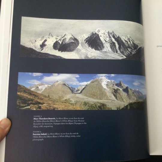
Image 2. Top: Marc Theodore Bourrit, “Le Mont Blanc vu en face du coté de l’Allée-Blanche,” from Horace-Benedict de Saussure, Voyages dans les Allpes, 1786, engraving. Bottom: Patrizia Imhof, Le Mont Blanc vu en face du coté de, l’Allée-Blanche, 2009, color photograph Description: Two photographs showing the difference in the amount of ice and snow on Mont Blanc. Top image from 1786 shows a lot more amount of ice and snow covering the mountains. Bottom image shows very little snow on top of the mountains.
Image 3: Francois-Auguste Biard, Pêche au morse par des Groënlandais, vue de l’Océan Glacial (Greenlanders hunting walrus, view of the Polar Sea), Salon of 1841, oil on canvas. Description: A couple of fishing boats with fishermen in the foreground, surrounded by a number of large icebergs in the rough sea.
Vanishing ice : alpine and polar landscapes in art, 1775-2012 Matilsky, Barbara C. [author] 1st ed. Bellingham, Wash. : The Whatcom Museum ; Seattle, Wash. : Distributed by the University of Washington Press, 2013. 144 p. : col. ill. ; 28 cm. Language: English "This publication accompanies the touring exhibition, Vanishing ice : alpine and polar landscapes in art, 1775-2012, for the Whatcom Museum ... Whatcom Museum, Bellingham, Washington, November 2, 2013-March 2, 2014; El Paso Museum of Art, El Paso, Texas, June 1-August 24, 2014; McMichael Canadian Art Collection, Kleinberg, Ontario, October 11, 2014-January 11, 2015" 2013 HOLLIS number: 990138118670203941
#vanishingice#ice#icemelting#climatechange#environment#glaciers#icebergs#snow#polarlandscape#fineartslibrary#harvardfineartslibrary#Harvard#harvard library#harvardlibrary#montblanc#polarsea#Greenland
13 notes
·
View notes
Link
“In a vote on Tuesday night, Whatcom county’s council unanimously passed a measure that bans the construction of new refineries, coal-fired power plants and other fossil fuel-related infrastructure. The ordinance also places new restrictions on existing fossil fuel facilities, such as a requirement that any extra planet-heating gases emitted from any expansion be offset.
Whatcom county is located in the far north-west corner of Washington state, next to the Canadian border and abutting the Salish sea. The county hosts two of the state’s five oil refineries, with BP and Phillips 66 overseeing facilities at the Cherry Point complex that refines much of the oil from Canada and Alaska that is then distributed along the US west coast.
“There will be no new refineries, they won’t be able to get permits to export their product and while we will still have these dinosaur facilities already here it will be more challenging for them to expand,” said Todd Donovan, who is serving his second term on the council and was a major proponent of the new rule. “The future is clearly in renewable energy.””
Okay, let’s have more of this!
#washington state#fossil fuels#us news#environment#energy#hope#climate change#climate hope#climate action#climate policy
3 notes
·
View notes
Text
But you know - everyone loves facts, so that’s fun
41. President Richard Nixon was at Disney World when he infamously proclaimed, “I am not a crook.”
42. A group of flamingos is called a “flamboyance”.
43. The World Wrestling Federation (WWF) had to change their name to World Wrestling Entertainment (WWE) because of legal action taken by the World Wildlife Fund (WWF).
44. According to John Lennon, the imagery in the song “Lucy in the Sky with Diamonds” was inspired by the work of Lewis Carroll.
45. There are more than 7,000 different Caribbean islands, but only about 2% of them are inhabited.
46. It’s been estimated that a new baby can rob parents of anywhere between 400-750 hours of sleep in the first year.
47. Whatcom County in the state of Washington unanimously passed a resolution declaring the region a Sasquatch Protection and Refuge Area.
48. Titan, Saturn’s largest moon, is the only moon known to have a fully developed atmosphere. In fact, it is about 50% denser than Earth’s.
49. Since 1945, all British tanks have come equipped with tea making facilities.
50. Reno, Nevada is west of Los Angeles, California.
1 note
·
View note
Photo

URGENT - WINTER WEATHER MESSAGE
The National Weather Service has released a winter weather advisory for Pierce County and its surrounding counties including both King and Lewis county, among others. Therefore, with hazardous road conditions in mind, we recommend all staff remain in Thornewood until the storm clears. Extra beds have been prepared on the first floor to accommodate overnight stays.
Read below for writer’s info and the full weather report:
𝒮𝑜𝓂𝑒 𝒢𝓊𝒾𝒹𝑒𝓁𝒾𝓃𝑒𝓈:
This is a completely impromptu event, therefore...
Writers do not have to participate OR drop previous threads if participating
We are asking, however, that you only post starters (using the thornewood.event tag) for this optional event until Fri. January 31 at 12AM EST.
You may reply to open starters involving this optional event until you no longer feel they’re relevant/too old. We’d recommend the cut off point for these starters is near Feb 8, certainly before Valentine’s Day.
There’s no end date to this optional event, though we’d recommend you try to finish the thread within 2 to 3 weeks of starting it — solely to keep Thornewood progressing forward in new, recent threads. But please keep in mind this is a suggestion, not a rule.
If you choose to participate in the event, please check for more Thornewood updates as we will be posting updates about the building, the storm and more.
Thank Laurel for this event idea!
Have fun!
Read the full weather report from the National Weather Service below:
National Weather Service Seattle WA 301 AM PST Tue Jan 28 2020 WAZ567>569-280715- /O.EXT.KSEW.WW.Y.0010.200127T2301Z-200128T1800Z/ Cascades of Whatcom and Skagit Counties- Cascades of Snohomish and King Counties- Cascades of Pierce and Lewis Counties- including Concrete, Hamilton, Lyman, Maple Falls, Deming, Newhalem, Darrington, Baring, Stevens Pass, Skykomish, Snoqualmie Pass, Lakewood, Morton, Ashford, Packwood, Randle, Paradise, and Longmire 301 AM PST Tue Jan 28 2020 ...WINTER WEATHER ADVISORY NOW IN EFFECT UNTIL 4 AM PST WEDNESDAY... * WHAT...Snow with accumulation of around 10 inches in the passes tonight and Wednesday morning. Snow accumulation will be higher with windy conditions in the high terrain. * WHERE...Cascade mountains including the Mount Baker Ski Area, Stevens Pass and Snoqualmie Pass. * WHEN...Until 4 AM PST Wednesday. * IMPACTS...Plan on winter driving conditions on the passes. * ADDITIONAL INFORMATION...Dangerous avalanche conditions are expected to develop across the Cascades this evening and very dangerous conditions may develop tonight into Tuesday. Expect the threat of large and potentially naturally-triggered avalanches. PRECAUTIONARY/PREPAREDNESS ACTIONS... Slow down and use caution while traveling. For the latest road conditions in Washington state, call 5 1 1. && $$ www.weather.gov/seattle
1 note
·
View note
Photo

IN THESE TIMES
For Rosalinda Guillén, everything begins with food—and that means paying close attention to the treatment of workers at the foundation of the food system.
Standing recently on the steps of city hall in Bellingham, Washington, Guillén urged local lawmakers to defend the rights of undocumented farmworkers living and working in Whatcom County, home to 1,702 farms sprawled over more than 115,000 acres.
“In this city, that claims to be a liberal city, there is rampant racial profiling,” Guillen, executive director of the food and migrant justice organization Community to Community Development (C2C) based in Bellingham, said into a megaphone. She slammed a pattern of “arbitrary” detention and deportation and “clear cooperation” between local law enforcement and federal immigration authorities.
Since early 2017, Guillen and other local activists have held weekly protests to urge city council to pass a sanctuary city ordinance to help protect undocumented residents from deportation. In August, Immigration and Customs Enforcement detained at least 16 people in Bellingham—local rights groups claim the number was nearly 30—fueling calls for a sanctuary policy.
In the 88th week of C2C’s “Dignity Vigils” calling for councilors to make Bellingham a sanctuary city, more than 100 representatives of food and climate justice groups from across the United States and a handful of international activists—all gathered for the national assembly of the U.S. Food Sovereignty Alliance—joined the protest. Local organizers in Bellingham, taking the lead from farmworkers, draw a clear connection between migrant justice and food sovereignty. For them, as long as the people working closest to food’s roots as farmworkers are mistreated, including earning wages that don’t even allow them to put meals on their own tables, there’s no way to have dignified or just food choices up the food supply chain.
“Everybody has to eat,” Antonio Tovar, interim general secretary of the Farmworker Association of Florida, said to In These Times, underlining the “paradox” that farmworkers often cannot access healthy food. “When the decision about what to eat isn’t yours, you have no way to be free.”
“Tired of exploitation”
Undocumented farmworkers in the Bellingham area have won historic labor victories in recent years. In 2013, farmworkers formed a union, Familias Unidas por la Justicia, to fight for better working conditions at Sakuma Brothers Farm in Burlington, Washington. After nearly four years of walkouts and boycotts, the union secured a landmark contract guaranteeing berry harvesters a minimum hourly rate of $15. In the process, the union also won paid 10 minute breaks for piecework farmworkers through a lawsuit against Sakuma in Washington’s Supreme Court.
Benito, a founding member of Familias Unidas and part of its leadership committee, said he now earns about double the pay for the same work—10 to 12 hour days, seven days a week—as a result of union organizing. “Many work rules are changing,” he told In These Times.
The union also successfully blocked Sakuma’s application to bring farmworkers through the H-2A Temporary Agricultural Workers visa program by collecting farmworkers’ signatures to disprove the company’s claims of labor shortages in and around Washington state, Ramón Torres, president of Familias Unidas, told In These Times. He argued that the fact that migrants with H-2A visas aren’t well informed of their rights enables employers to “enslave” workers. “The other thing is that they use [H-2A] to break our union, strikes, or movements,” Torres added.
Building on the union’s success, Torres and three other members of Familias Unidas launched a farmworker-owned cooperative last year with a vision of creating better working conditions, autonomy, and adequate access to healthy food for farmworkers.
“We have to go ask for [food] stamps. We have to go to food banks. And it’s not just,” Torres said. “A farmworker who picks watermelons in the end can’t buy the watermelon because he doesn’t earn a fair salary to afford it.”
At the Bellingham Food Bank, project coordinator Max Morange told In These Times that farmworkers are among the Food Bank’s clients, though the organization does not collect any demographic data. And although identification is not required and individuals can access the food bank regardless of immigration status, Morange said he has observed a correlation between “fear and uncertainty” fueled by immigration enforcement in the community and who he sees walk through the food bank doors.
(Continue Reading)
109 notes
·
View notes
Photo

Weather: Pacific Northwest
Report generated at 2024-12-25 16:00:10.377378-08:00 using satellite imagery and alert data provided by the National Weather Service.
Winter Storm Warning
WA:
Central Chelan County
Lower Slopes of the Eastern Washington Cascades Crest
Okanogan Highlands
Okanogan Valley
Olympics
Upper Slopes of the Eastern Washington Cascades Crest
Waterville Plateau
Wenatchee Area
West Slopes North Cascades and Passes
West Slopes North Central Cascades and Passes
West Slopes South Central Cascades and Passes
Western Chelan County
Western Okanogan County
ID:
Bear River Range
Big Hole Mountains
Big Lost Highlands/Copper Basin
Blackfoot Mountains
Caribou Range
Centennial Mountains/Island Park
Franklin/Eastern Oneida Region
Marsh and Arbon Highlands
Raft River Region
Sawtooth/Stanley Basin
Southern Hills/Albion Mountains
Sun Valley Region
Teton Valley
Wood River Foothills
Winter Weather Advisory
WA:
Cascades of Lane County
Cascades of Marion and Linn Counties
North Oregon Cascades
Northeast Mountains
Northern Blue Mountains of Oregon
Northwest Blue Mountains
South Washington Cascades
Upper Columbia Basin
OR:
Baker County
Cascades of Lane County
Cascades of Marion and Linn Counties
East Slopes of the Oregon Cascades
North Central and Southeast Siskiyou County
North Oregon Cascades
Northern Blue Mountains of Oregon
Northwest Blue Mountains
Siskiyou Mountains and Southern Oregon Cascades
South Central Oregon Cascades
South Central Siskiyou County
South Washington Cascades
Upper Weiser River
Western Siskiyou County
ID:
Arco/Mud Lake Desert
Baker County
Bear Lake Valley
Beaverhead/Lemhi Highlands
Boise Mountains
Camas Prairie
Central Panhandle Mountains
Eastern Magic Valley
Frank Church Wilderness
Lost River Range
Lower Snake River Plain
Northern Clearwater Mountains
Northern Panhandle
Shoshone/Lava Beds
Southern Clearwater Mountains
Upper Snake River Plain
Upper Treasure Valley
Upper Weiser River
West Central Mountains
Western Magic Valley
CA:
Greater Lake Tahoe Area
Lassen-Eastern Plumas-Eastern Sierra Counties
Mono
North Central and Southeast Siskiyou County
Northern Trinity
Siskiyou Mountains and Southern Oregon Cascades
South Central Oregon Cascades
South Central Siskiyou County
West Slope Northern Sierra Nevada
Western Plumas County/Lassen Park
Western Siskiyou County
NV:
Greater Lake Tahoe Area
Northern Elko County
Ruby Mountains and East Humboldt Range
South Central Elko County
Southwest Elko County
Coastal Flood Warning
WA:
Central Coast
Coastal Flood Advisory
WA:
Eastern Strait of Juan de Fuca
North Coast
South Washington Coast
Western Strait of Juan De Fuca
High Surf Advisory
WA:
Central Coast
North Coast
South Washington Coast
OR:
Central Coast of Oregon
Clatsop County Coast
Tillamook County Coast
CA:
Catalina and Santa Barbara Islands
Coastal Del Norte
Coastal North Bay Including Point Reyes National Seashore
Los Angeles County Beaches
Malibu Coast
Mendocino Coast
Northern Humboldt Coast
Northern Monterey Bay
San Diego County Coastal Areas
San Francisco
San Francisco Peninsula Coast
San Luis Obispo County Beaches
Santa Barbara County Central Coast Beaches
Santa Barbara County Southeastern Coast
Santa Barbara County Southwestern Coast
Southern Monterey Bay and Big Sur Coast
Southwestern Humboldt
Ventura County Beaches
High Wind Warning
WA:
Admiralty Inlet Area
Central Coast
Clatsop County Coast
North Coast
San Juan County
South Washington Coast
Western Skagit County
Western Whatcom County
Willapa Hills
OR:
Central Coast of Oregon
Central and Eastern Lake County
Clatsop County Coast
Curry County Coast
Modoc County
Northern and Eastern Klamath County and Western Lake County
South Central Oregon Coast
South Washington Coast
Tillamook County Coast
ID:
Orofino/Grangeville Region
CA:
Central and Eastern Lake County
Coastal Del Norte
Modoc County
Northern and Eastern Klamath County and Western Lake County
Wind Advisory
WA:
Admiralty Inlet Area
Bellevue and Vicinity
Bremerton and Vicinity
Central Panhandle Mountains
Coeur d'Alene Area
East Puget Sound Lowlands
Everett and Vicinity
Foothills of the Blue Mountains of Washington
Foothills of the Northern Blue Mountains of Oregon
Hood Canal Area
Idaho Palouse
Lower Chehalis Valley Area
Lower Garfield and Asotin Counties
San Juan County
Seattle and Vicinity
Southwest Interior
Spokane Area
Tacoma Area
Upper Columbia Basin
Washington Palouse
Western Skagit County
Western Whatcom County
OR:
Central Oregon
Eastern Curry County and Josephine County
Foothills of the Blue Mountains of Washington
Foothills of the Northern Blue Mountains of Oregon
Foothills of the Southern Blue Mountains of Oregon
Grande Ronde Valley
Jackson County
North Central Oregon
ID:
Central Panhandle Mountains
Coeur d'Alene Area
Idaho Palouse
Lewis and Southern Nez Perce Counties
Spokane Area
Washington Palouse
CA:
Central Siskiyou County
Del Norte Interior
Greater Reno-Carson City-Minden Area
Interstate 5 Corridor
Northern Humboldt Coast
Northern Humboldt Interior
Northern Ventura County Mountains
Northern Washoe County
Santa Barbara County Interior Mountains
Santa Barbara County Southwestern Coast
Santa Ynez Mountains Eastern Range
Santa Ynez Mountains Western Range
Southern Humboldt Interior
Southern Ventura County Mountains
Southwestern Humboldt
Surprise Valley California
NV:
Greater Reno-Carson City-Minden Area
Northern Washoe County
Surprise Valley California
Hydrologic Outlook
WA:
Grays Harbor
Flood Watch
WA:
Clallam
Flood Warning
WA:
Mason
High Surf Warning
OR:
Curry County Coast
South Central Oregon Coast
Lake Wind Advisory
NV:
Western Nevada Basin and Range including Pyramid Lake
4 notes
·
View notes
Text
North Fork Brewery raises funds for Old Dog Haven with the release of Gray Muzzle IPA, in support of the Shadow Hike-A-Thon
Press Release
The North Fork Brewery in Whatcom County will be joining forces with a local husband and wife team to raise funds in support of Old Dog Haven, a Washington based non-profit organization. As they have done for previous hike-a-thons since initially becoming involved with the event in 2012, The North Fork Brewery has created a featured beer to coincide with the fundraiser. The charity brew, Gray Muzzle IPA, will be available at their location on Mt. Baker Highway, plus at ten additional establishments throughout Whatcom County and Seattle.
Jennifer and Jason Sonker have hosted the Shadow Hike-A-Thon fundraiser, in memory of their little dog Shadow, since she tragically passed away in 2011. Over the past eight years, the event has raised more than $55,000 for local animal charities, with $14,000 of that going to Old Dog Haven in 2018. The couple credits their partnership with The North Fork Brewery for the success of the event. “Folks in the PNW really love hiking, beer, and dogs so we feel like this is the perfect combination for the event’s continued success” states Jason.
The Shadow Hike-A-Thon takes place June 20-23, 2019. Additional details including hiking times, locations, and how to make a donation in support of the event can be found at: www.facebook.com/events/384012745530205.
The North Fork Brewery, Pizzeria, and Beer Shrine located at 6186 Mt Baker Highway, Deming features freshly-brewed, small batch ales, lagers and barrel-aged sours and is well known for its hand tossed pizza. The restaurant opens at 12:00pm, seven days a week, and welcomes diners of all ages. Find more information about The North Fork Brewery at www.northforkbrewery.com
from News - The Northwest Beer Guide http://bit.ly/2ZBmL0p
1 note
·
View note
Text
Northwest Ambulance Critical Care Transport has shortage of EMT’s
Snohomish County, February 23 – Northwest Ambulance Critical Care Transport serving the area from Pierce County to Whatcom County is currently looking for fast track candidates to join their team and start work immediately. All costs are covered, and no experience is required to start EMT training.
Northwest Ambulance located at 8115 Broadway in Everett serves up to Burlington and down to Puyallup. EMS in this area is busy and the job market for EMT’s is good. Starting in private ambulance service delivers entry-level on-the-job training and opportunities to advance into paramedic and RN. Still, with on-the-job training and room for advancement, private companies often have high turnover because of high customer focus and entry-level workers moving in EMS.

Northwest Ambulance House located on 8115 Broadway, Everett, WA 98203.
Snohomish County Assessor. (2023). [Northwest Ambulance Building Photo]. [Image]. https://scopi.snoco.org/Html5Viewer/Index.html?configBase=https://scopi.snoco.org/Geocortex/Essentials/REST/sites/SCOPI/viewers/SCOPI/virtualdirectory/Resources/Config/Default
“Our decade of experience has shown us that systems placing too much emphasis on financial gain do so at the expense of employees and customers. Organizations that put the major focus on customers often experience high employee turnover, creating a shortage of critical talent. Providers that yield to employee demands often are unable to sustain the cost of their practices,”. “The healthcare world is experiencing staffing challenges. We are working to get on top of this and are actively expanding our operations as others are unable,” (Northwest Ambulance, 2023).
Figure 1
Total Population and Percent Change in Washington.

Note. From Total Population and Percent Change, by Washington Office of Financial Management, 2023,
(https://ofm.wa.gov/washington-data-research/statewide-data/washington-trends/population-changes/total-population-and-percent-change).
Papken O’Farrell, Public Safety Department Director at Everett Community College and former Program Manager of Public Policy and Governance – Daniel J. Evans School – Executive Master of Public Administration at UW, Seattle talks about public safety in the area. There are three reasons that should be noted. First, Covid delayed and pushed out retirement. Now there is surge of retirement. Probably the largest retirement in 50 years. Second, increased population has put higher demand on the fire system. A few years ago, Washington was ranked about fifth in population growth. Third, people in emergency services were required to get the Covid vaccine. A lot have left during the vaccine requirement in fire service from November 2021 to about December of 2022. Lots of people, especially entry-level, just didn’t want to get the vaccine.
88% of fire response in the emergency medical system is medical. Only the remaining 12% is responding to a building on fire. A primary requirement to becoming a qualified firefighter is passing EMT certification.
There is no one path to becoming a firefighter/paramedic. Every fire department uses a different process for recruiting, training, and hiring. For example, on-the-job training with a fire department, regional authority or private emergency transport service like Northwest Ambulance. Other career training is available through professional certifications, college-level academic studies and volunteering, particularly in rural communities.
Basic certifications for firefighter build skills in preparation to respond in medical and fire hazard emergencies. One of the first ways to prepare is EMT certification through the Washington State Fire Marshal Office and National Testing Network. It isn’t always a requirement upon initial employment but usually is within the first year of employment. The cost of certifications can be high with several thousand dollars out-of-pocket through training, testing and certification.
Zach Hanson from North County Regional Fire in Arlington talks about starting as an entry-level EMT, “One piece of advice I can give you is keep testing. Some people test once for their first time, pass, and become a fire EMT. Some, for others, it takes longer, up to 10 years to get all the qualifications. Just keep testing, stay in school and you’ll eventually get it. One last thing is check out EvCC’s fire program. They have a really good one,”.

Zach Hanson describes his experience as an EMT and gives advice for an entry-level EMT.
References
Northwest Ambulance. (n.d.). About Northwest Ambulance. https://www.nwamb.us/about-us
Office of Financial Management. (2023). Total population and Percent Change. [Bar graph]. Retrieved February 18, 2023, from https://ofm.wa.gov/washington-data-research/statewide-data/washington-trends/population-changes/total-population-and-percent-change
Snohomish County Assessor. (2023). [Northwest Ambulance Building Photo]. [Image]. https://scopi.snoco.org/Html5Viewer/Index.html?configBase=https://scopi.snoco.org/Geocortex/Essentials/REST/sites/SCOPI/viewers/SCOPI/virtualdirectory/Resources/Config/Default
0 notes
Text
Team effort boosts hikers 60 miles over Whatcom Pass in North Cascades - Fri, 08 Sep 2017 PST
Three days into a strenuous trek deep into the middle of North Cascades National Park, my hiking partner Matt asked, “Has this trip been on your bucket list for a while?” Well, yes. But this wasn’t what I had in mind. Team effort boosts hikers 60 miles over Whatcom Pass in North Cascades - Fri, 08 Sep 2017 PST
#Spokesman.com: Latest stories#Team effort boosts hikers 60 miles over Whatcom Pass in North Cascade
0 notes
Link
Duane Paul Sammons was a man of many dimensions. He was a civic leader, an insurance entrepreneur, a seventh-degree black belt in karate, a musician and – most importantly – a man who held family and community in the highest regard.
I had the honor of talking with Aubrey Kornelis about her grandfather Duane Sammons, a community leader in Whatcom County. He passed away this year, and is remembered by many for what he gave to his family and community.
#whatcom county#whatcom#duane sammons#music#karate#insurance#civics#musician#pacific northwest#pnw#bellingham#bellingham wa
1 note
·
View note
Conversation
U.S. Daily Precipitation Records Tied/Broken 3/17/22
Unincorporated Park County, Colorado: 0.27" (previous record 0.21" 2008)
Boulder, Colorado: 0.97" (previous record 0.56" 1934)
Unincorporated Weld County, Colorado: 0.47" (previous record 0.44" 1986)
Cañon City, Colorado: 0.41" (previous record 0.4" 1906)
Pike National Forest, Colorado: 0.8" (previous record 0.33" 2008)
Unincorporated El Paso County, Colorado: 0.93" (previous record 0.32" 1987)
Unincorporated Jefferson County, Colorado: 0.9" (previous record 0.5" 2008)
Unincorporated Park County, Colorado: 0.85" (previous record 0.28" 1996)
Greeley, Colorado: 0.72" (previous record 0.17" 2008)
Unincorporated Boulder County, Colorado: 0.75" (previous record 0.6" 2008)
Lakewood, Colorado: 0.59" (previous record 0.34" 2008)
Unincorporated Logan County, Colorado: 0.5" (previous record 0.32" 1961)
Unincorporated Washington County, Colorado: 0.23" (previous record 0.11" 1991)
Unincorporated Boulder County, Colorado: 0.55" (previous record 0.36" 1958)
Northglenn, Colorado: 0.7" (previous record 0.5" 2003)
Unincorporated Jefferson County, Colorado: 1.06" (previous record 0.25" 2008)
Unincorporated Sedgwick County, Colorado: 0.79" (previous record 0.45" 1983)
Wheat Ridge, Colorado: 0.75" (previous record 0.66" 2003)
Winter Park, Colorado: 0.7" (previous record 0.51" 1991)
Unincorporated Yuma County, Colorado: 0.57" (previous record 0.24" 2008)
Unincorporated Costilla County, Colorado: 0.7" (also 0.7" 1996)
Schofield Pass summit, Colorado: 1.8" (previous record 0.7" 1996)
Denver, Colorado: 0.55" (previous record 0.3" 1951)
Unincorporated Pueblo County, Colorado: 0.32" (previous record 0.27" 1961)
Unincorporated Garden County, Nebraska: 0.5" (previous record 0.44" 1996)
Unincorporated Orange County, North Carolina: 2.38" (previous record 1.78" 2007)
Unincorporated Alamance County, North Carolina: 2.55" (previous record 1.45" 2000)
Unincorporated Dare County, North Carolina: 1.18" (previous record 0.84" 1983)
Darlington, South Carolina: 2.52" (previous record 2.46" 1983)
Manning, South Carolina: 1.77" (previous record 1.34" 2021)
Sumter, South Carolina: 4.2" (previous record 1.54" 1948)
Louisa, Virginia: 1.57" (previous record 1.51" 1990)
South Boston, Virginia: 1.21" (previous record 1.13" 2007)
Unincorporated Whatcom County, Washington: 0.64" (previous record 0.53" 2007)
Fort Laramie National Historic Site, Wyoming: 0.18" (previous record 0.09" 1993)
Craig, Alaska: 1.18" (previous record 0.99" 2021)
Flattop Mt. summit, Montana: 1.8" (previous record 1.1" 2013)
St. Joe National Forest, Idaho: 2.2" (previous record 1.3" 1994)
Unincorporated St. Mary's County, Maryland: 2.4" (previous record 1.69" 1990)
Annapolis, Maryland: 0.52" (previous record 0.32" 1960)
Unincorporated Colfax County, New Mexico: 0.16" (previous record 0.11" 2001)
#Storms#U.S.A.#U.S.#Colorado#1930s#1980s#1900s#1990s#1960s#1950s#Nebraska#North Carolina#South Carolina#1940s#Virginia#Washington#Wyoming#Alaska#Montana#Idaho#Maryland#New Mexico
0 notes
Text
A British Columbia couple is warning other travellers to “do your homework” after being stranded in Washington state for two nights and a day, unable to find a rapid test for COVID-19.
April Lewis and her partner Martin Clingwall were returning from a seven-week stay in Palm Springs and hoping to cross the border into B.C. on Saturday. They knew they needed a negative test result, but had no idea how tricky it would be to find a test.
“I honestly, trult thought it would be a piece of cake—that every pharmacy in the Bellingham area would be welcoming us with open arms, saying, ‘Canadians, we love you, come!'” Lewis stated Sunday, from a hotel in the American city south of Langley.
“We didn’t think to book online, we should have perhaps booked online and we could have got one maybe in Seattle.” In February, the federal government eased testing requirements for fully-vaccinated Canadians, allowing them to produce a negative rapid test result instead of a PCR result, as long as the test was administered by a health-care entity or lab.
Lewis said several staff at several Bellingham pharmacies told her online reservations were required for a rapid test, but even if they had made one, there was no stock of rapid antigens tests available in Whatcom County at the time.
The couple tried to get one at the local airport, but without an appointment, had were turned away there as well. Eventually, Lewis contacted her local MP on Facebook.
Kerry-Lynne Findlay, who represents South Surrey-White Rock, was able to book them a rapid test appointment for Tuesday in Birch Bay, about 30 minutes away from their hotel in Bellingham.
“Thank goodness we can afford it,” Lewis said of the hotel stay. “I can’t believe we’re the only people this has happened to… is everyone else a lot smarter than me and pre-booked online?”
After repeated visits and calls to pharmacies, the couple found a rapid test on Monday, passed it and went home. As spring break kicks off, Lewis is urging other travellers to “do your research,” and ensure they make rapid test appointment in advance. With many provinces relaxing most, if not all pandemic public health measures, she also called on the federal government to ease testing requirements at the border.
“This is nonsense,” she said. “Seriously, Mr. Trudeau, if you’re listening, I’m triple-vaxxed — what more do you want, my first-born child?” The Surrey Board of Trade, concerned about the struggling tourism industry, echoed her calls.
“What has happened to that poor couple is absolutely unacceptable,” stated Surrey Board of Trade president Anita Huberman. “Surrey is a border city and we need to ensure that border is fully open.
“I think the clear strategy for the federal government is to remove all of these testing requirements for fully-vaccinated travellers.”
0 notes