#Historical map
Explore tagged Tumblr posts
Visit Tumblr Blog
Explore Tumblr blogs with no restrictions, modern design and the best experience.
Last Seen Tumblr Blogs


Fun Fact
1,644 Tumblr posts in 1 second.
Text
Imperial Federation Map of the World Showing the Extent of the British Empire in 1886 - Boston Public Library

(And tutorial to make it into a little house 🖤)
2 notes
·
View notes
Text


Map 1: The Idumaean and Arab Penetration during the Persian Period 6-4 Centuries BCE)
Map 3: The luraean Zone of Action
0 notes
Text

I actively had to look into my archive to see if I used to post maps here in the past, but at any rate: Croats & Croatia at 5 points in time All information like refs are embedded on the image again.
0 notes
Text

Leaves turn inside you
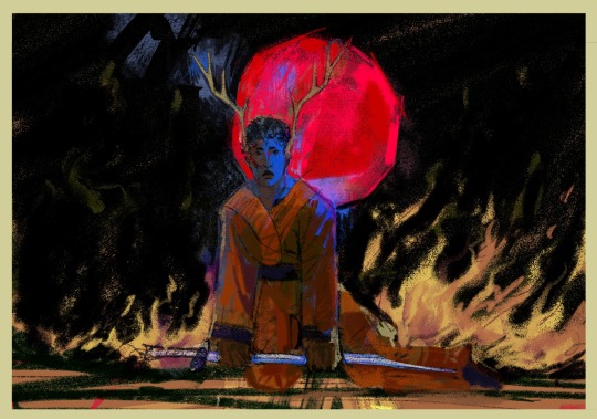
#ninjago#arin ninjago#ninjago fanart#dragons rising#rewatched the glorious historical hollyfawn map and thought arin needs antlers too#I think he‘s so incredibly compelling
175 notes
·
View notes
Text
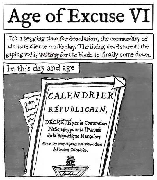
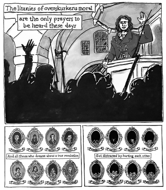
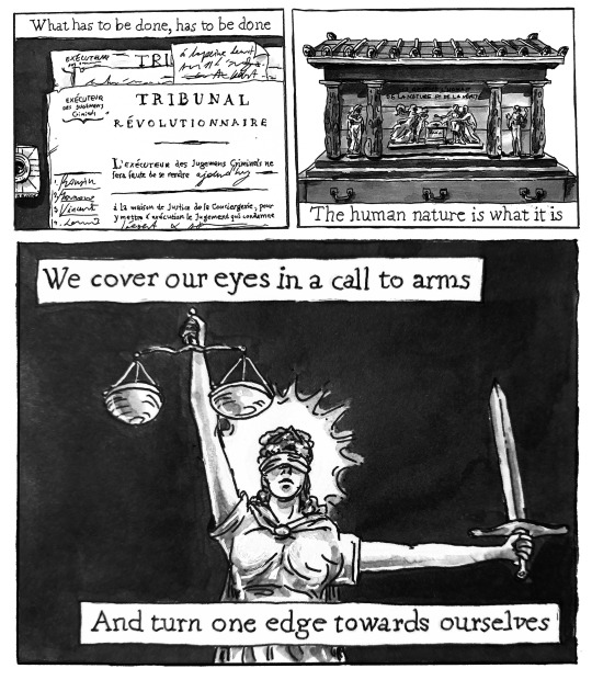
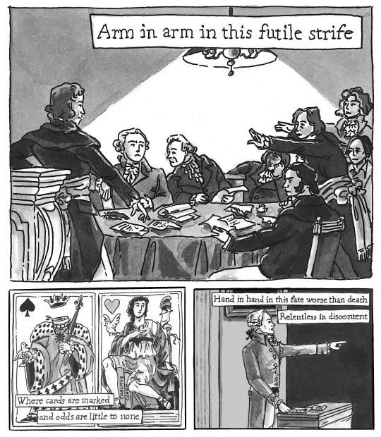
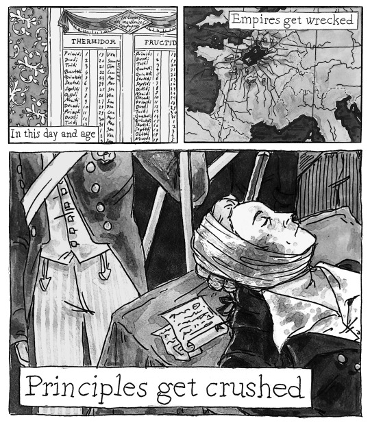
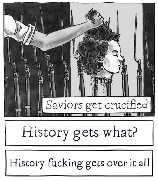
Le 9 Thermidor, l'an II de la République une & indivisible / Age of Excuse VI, Mgła
#My art#History#French Revolution#Frev#Thermidor#Robespierre#Almost two weeks in the making. /Really/ pleased with how pages 4 and 5 turned out.#The order of execution and both calendars are copied verbatim from historical documents.#As is the map. (To an extent obviously.)
281 notes
·
View notes
Text
There was a village tucked in a narrow valley between steep woods. It wasn't a large village, and wouldn't have shown up on a map of the mountains. It barely showed up on a map of the village.
It was, in fact, one of those places that exist merely so that people can have come from them. The universe is littered with them: hidden villages, windswept little towns under wide skies, isolated cabins on chilly mountains, whose only mark on history is to be the incredibly ordinary place where something extraordinary started to happen. Often there is no more than a little plaque to reveal that, against all gynecological probability, someone very famous was born halfway up a wall.
Terry Pratchett, Equal Rites
#equal rites#discworld#terry pratchett#small towns#small town life#origin story#geography#cartography#maps#importance#ordinary#extraordinary#landmarks#history#historical significance#an incredibly ordinary place#halfway up a wall
325 notes
·
View notes
Text

Map exhibiting points of interest along the air route of National Park Airways, the forerunner of Western Airlines - 1929.
#vintage illustration#the 1920s#air lines#airlines#vintage aircraft#commercial aircraft#vintage travel#vintage air travel#air travel#aircraft#maps#vintage maps#cartography#cartographs#national park airways#air mail#air mail carriers#idaho#montana#utah#western airlines#historical maps#travel maps#pictorial maps
67 notes
·
View notes
Text
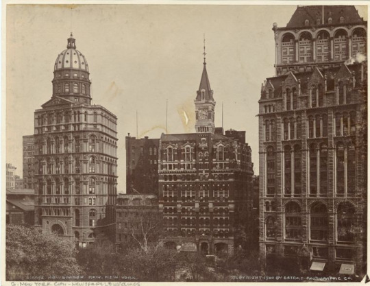
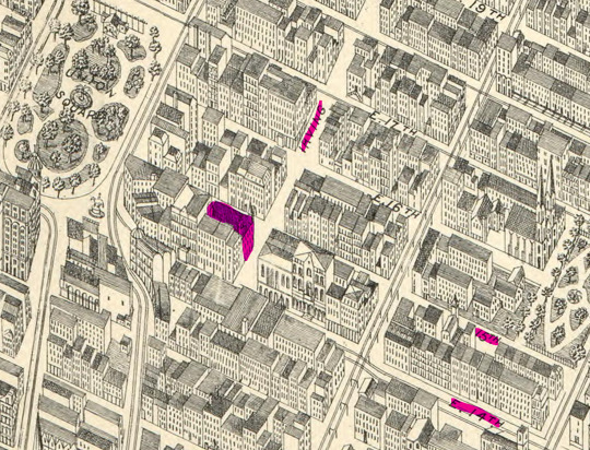
I found another map! Bird's-eye-view of Manhattan and adjacent districts, New York City, c 1903(?)

Red: The Brooklyn Bridge Yellow: The New York World Building Green: Duane Street and the Newsboys' Lodging House Blue: Baxter Street, the location of the Jacobs family's tenement apartment according to the original Hard Promises script

Here's a closer view of the lodging house (green) and "Newspaper Row."
Newspaper Row, or Park Row, ia adjacent to City Hall Park and was the location of the World (yellow), the Sun (obscured by the Tribune), the Tribune (blue), and the times (red) in the late 19th century. [source]
Newspaper Row, c 1900. Left to Right: the New York World, The Sun, The Tribune, and the New York Times.
The New York Tribune, founded by Horace Greely in 1841, was the original location of the Horace Greely statue featured in Newsies. It was dedicated in 1890 and was later moved from the Tribune to City Hall Park in 1915 where it still stands today.
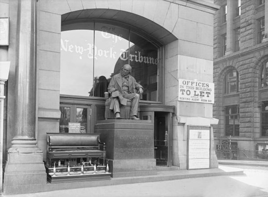
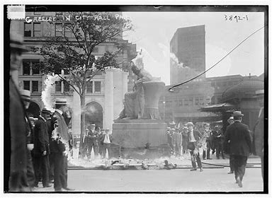
Horace Greeley Statue Outside New York Tribune Building, c January 1, 1900. and Greeley statue in City Hall Park, c 1915 - 1920.
The New York Sun, at which Bryan Denton and Katherine Plumber work, was located beside the Tribune on the intersection of Nassau and Frankfort streets.

"The Sun," 1893 black and white halftone print.
The Newsboy's Lodging House, or the Brace Memorial Lodging House, was opened in 1874 by the Children's Aid Society. It stood at the intersection of three streets: William Street, Duane Street, and Chambers Street (all three of which I have highlighted in green in the above map). In 1899, the lodging house's address was 9 Duane Street. [source]
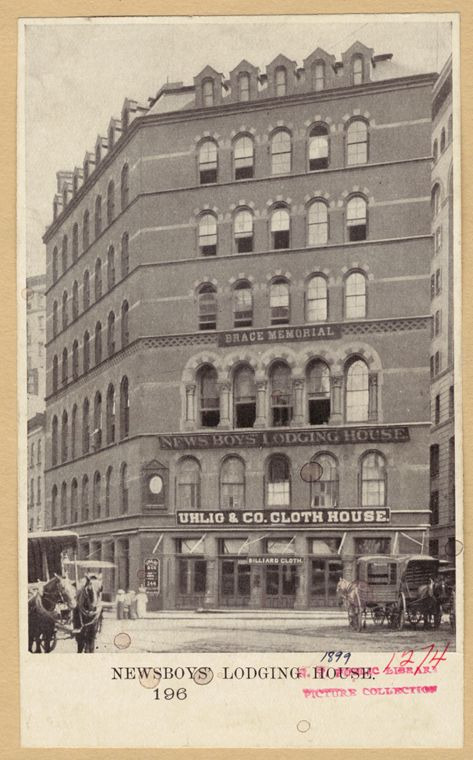
Newsboys' Lodging House, c 1899.
If you travel up north, you can also locate on this map the Irving Place Theatre, otherwise known as Irving Hall or Medda's Theatre.
Originally opened in 1860 as Irving Hall, Irving Place Theatre was rebuilt in 1888 as "Amberg's German Theatre." It became known as the Irving Place Theatre in 1893. [source]
The theatre's address was 118 E. 15th Street and was located between 14th and 15th streets, at the southwest corner of 15th street and Irving Place. Irving Place Theatre was demolished in 1894 to build the Zeckendorf Towers. [source]


Top: Irving Place Theatre, undated. Bottom: Irving Place Theatre, c 1912.
---
(link to reblog with the refuge added)
#newsies#newsies 1992#1992 newsies#1992sies#92sies#history#historical photos#maps#nerd alert!#my writing#jack kelly#david jacobs#bryan denton#katherine plumber#medda larkson#medda larkin
92 notes
·
View notes
Text
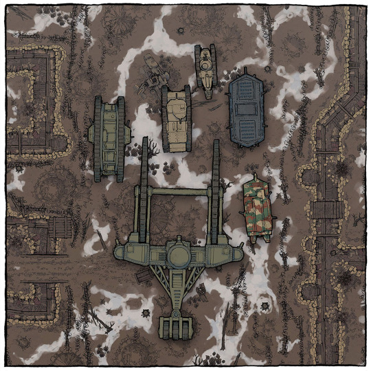
You hear the rumble of tanks approaching... They're here for you to download! Come check out my 6 new, hand-drawn WW1 tanks.
→ Download them here!
(There's even a Tsar tank!)
#ttrpg#tabletop#dungeons and dragons#dnd#dungeons & dragons#d&d#d&d5e#pathfinder#gurps#rpg#top-down#battle map#map#cartography#encounter#world war#great war#western front#trenches#battlefield#no mans land#no man's land#bolt action#tank#through the mud and blood#historical#warfare#firelock#flames of war#crossfire
90 notes
·
View notes
Text

BEST IMMERSIVE SIMS 4 MAP REPLACEMENTS (DETAILED, ARTISTIC, AND HISTORICAL MAPS TO IMPROVE YOUR WORLDS!)
After playing the sims 4 for so many years, the standard maps start to get tiring to look at. And just like curating your loading screen and CAS backgrounds to fit the vibe of your gameplay, maps are a great way to customize your experience.
And for my historical girlies, I even have a few overrides for you! 👀
—
CHECK OUT THE FULL POST HERE
#ts4 cc#sims 4 cc#sims 4#ts4#ts4 mm#sims 4 mm#maxis match#sims 4 mods#ts4 mods#maxis match cc#ts4 map replacement#sims 4 map replacement#cc map replacement#ts4 hsitorical cc#sims 4 historical cc#historical map replacement
884 notes
·
View notes
Text
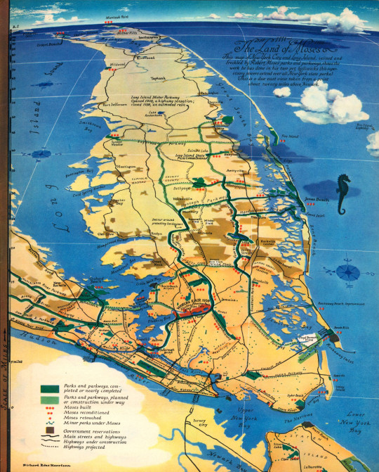
1938 map of New York City and Long Island focused on the works of Robert Moses titled "The Land of Moses."
Source: Rachel Cole, curator, Northwestern University Transportation Library.
https://bsky.app/profile/rmartincole.bsky.social/post/3lktg6mr3xk2n
37 notes
·
View notes
Text


#ts4#the sims 4#ts4 historical#wip#test family#textures are just not texturing for me#so I decided to add a kitchen sink on top of everything...with rose aroma#hope proper maps will be able to add some dimension to those flowers because right now they look a little...plane
82 notes
·
View notes
Text
Prussia in 6 historical timestamps
yep, though this one was a bit more rushed I got to make a new series... All the relevant info & citations are embedded on the images themselves. Prussia is a region in eastern Europe /the baltics, also used to be a country. It went from a monastic order, to a divided secular state, to personal union, to empire until the end of WW1 before ending completely with the end of WW2. For more information if needed check the individual maps or ask me directly, cause that might take more than the character limit to give explanations.

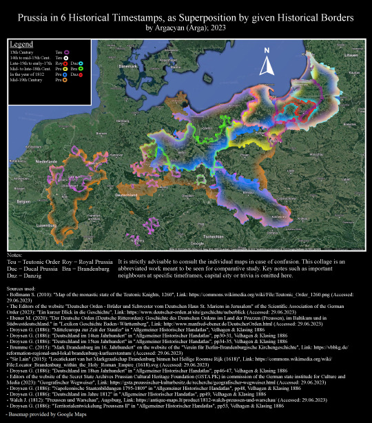


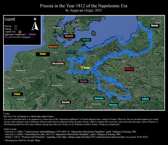

#map#maps#europe#historical map#history#germany#prussia#poland#eastern europe#baltic countries#baltic history#baltic states#germanic#teutonic order#german order#brandenburg
0 notes
Text
god fucking dammit it is 10 pm and i am here frantically scribbling PAGES OF NOTES for a KCD fic idea
while also making a playlist for it
fuck my life
#i hate it here!!!!#and by here i mean my brain#i don't want to do this because i never finish ANYTHING and it's just another thing i'll feel guilty about#but i canNOT get this stupid idea out of my head and unfortunately the idea absolutely fucks so#kcd#i'm literally sitting here doing HISTORICAL RESEARCH#i'm looking at MAPS of Czechia!!!!!#i have latitude and longitudes written down god help me i am DISEASED#kingdom come deliverance
20 notes
·
View notes
Text

Trans World Airline world route map - 1948.
#vintage illustration#twa#trans world airlines#transoceanic flight#40s#the 1940s#luxury air travel#air lines#airlines#vintage aircraft#commercial aircraft#vintage travel#vintage air travel#air travel#aircraft#airliners#lockheed constellation#lockheed connie#maps#vintage maps#cartography#historical maps#travel maps#pictorial maps
62 notes
·
View notes
Text
Tropes + snippet for my gothic werewolf book coming out in May💕🐺

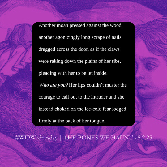
#WIP : the bones we haunt#yes those are gutave doré red riding hood illustrations heehee🥰#werewolf#monster romance#writing community#writeblr#writeblr wip#trope map#indie author#beauty and the beast#werewolf wednesday#werewolf romance#wip wednesday#writing#gothic romance#gothic book#historical romance
36 notes
·
View notes