
This blog brings you results of geospatial image analysis methods, data and meta-data visualization and analytics methods, digital cartography and GIS projects, satellite imagery and beyond. It is maintained by Georgios K. Ouzounis. The opinions expressed in posts by the author are not those of the author's employer and/or volunteer affiliations.
Don't wanna be here? Send us removal request.
Statistics
We looked inside some of the posts by alphatree and here's what we found interesting.
Average Info
Notes Per Post
3K
Likes Per Post
2K
Reblog Per Post
785
Reply Per Post
9
Time Between Posts
21 days
Number of Posts By Type
Text
12
Photo
5
Last Seen Tumblr Blogs


Fun Fact
Tumblr Inc. is using 66 technologies for its website.
Text

Thank you @human-recondition and everyone who got me to 100 reblogs!


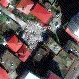
Atlas of Human Settlements
Inland Empire, CA, 2023
12 notes
·
View notes
Text
Atlas of Human Settlements
Inland Empire, CA, 2023
#satellite#segmentation#remote sensing#builtup#atlasofhumansettlements#georgios ouzounis#deep learning#ai#artificial intelligence
12 notes
·
View notes
Text

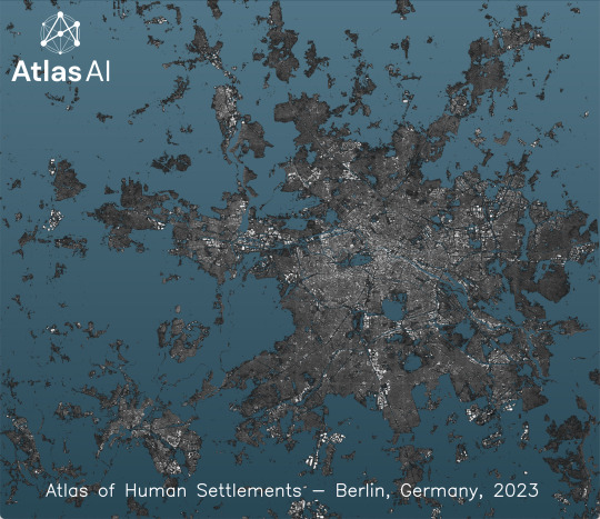
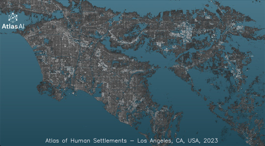
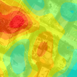
The Atlas of Human Settlements (AHS) v4.0 is just out!
AHS is built-up basemap of global extent, delivered at 10m spatial resolution and updated annually, with legacy layers going back to 2016. Version 4.0 features many quality improvements and additional raster and vector layers. Check it out in the official Atlas AI website at https://www.atlasai.co/ .
The images show the Built-up Index layer of major cities across the world.
#remote sensing#satellite#segmentation#atlasofhumansettlements#atlasai#deep learning#bigdata#georgios ouzounis#builtup#maps#basemap
3 notes
·
View notes
Text


Today, March 15th, is known as the “Ides of March” and infamously marks the assassination of Roman leader Julius Caesar. Here’s a gallery of Rome Overviews, featuring:
The Roman Colosseum
Rome along the Tiber River
Balduina, a residential neighborhood
Prati, a neighborhood in central Rome
Source imagery: Bachir Moukarzel / Maxar
200 notes
·
View notes
Text

Today's Overview captures the sprawling metropolitan area of Athens, Greece — home to over 3.7 million people and spanning nearly 3,000 square kilometers (1,131 sq mi). With ancient landmarks like the Acropolis and the Parthenon amid bustling city streets, Athens has a unique blend of history, culture and modernity. Some municipalities captured in this Overview include Egaleo, Pireas, Kallithea and Glyfada.
37.981779°, 23.727256°
Source imagery: Maxar
129 notes
·
View notes
Photo

Shaded relief map of the Cyclades islands.
by @spiragio
67 notes
·
View notes
Photo

Population density map of North Korea.
by @researchremora
77 notes
·
View notes
Text


Happy Pi Day! There are many circular sights to see from the Overview perspective. Here are a few of our favorites:
Pingyuan Reservoir, China
Nardò Ring, Italy
Apple Park, California, USA
Seville Solar Concentrator, Spain
Great Blue Hole, Belize
Source imagery: Maxar / Nearmap
493 notes
·
View notes
Photo
beautiful visualization!

Texas population density map.
by @MrPecners
113 notes
·
View notes
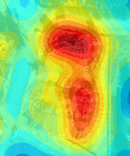
Photo

2023 Turkey Earthquakes Building Damage Assessment Map is live on:
https://hasar.6subatdepremi.org/
10.2K buildings collapsed
5.71K Needs to be demolished
42.5K Heavily Damaged
140K Slightly Damaged
by @asturksever
45 notes
·
View notes
Text

Beijing Daxing International Airport is one of two international airports serving Beijing, China. Its star-shaped terminal building, seen here, is the largest single-structure airport terminal in the world at about 700,000 square meters (7.5 million square feet). Daxing began operations in September 2019 and has served more than 50 million passengers since.
39.509040°, 116.411530°
Source imagery: Maxar
241 notes
·
View notes
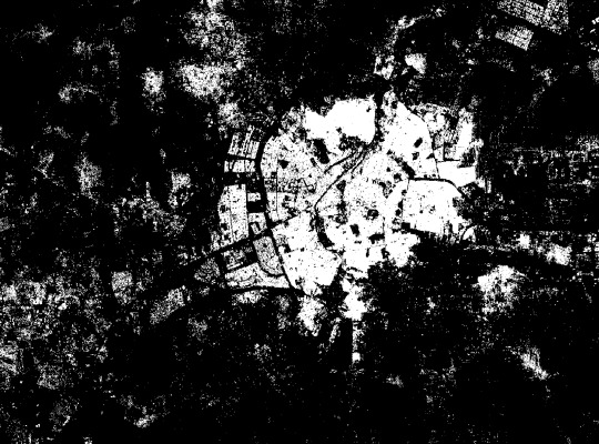
Text


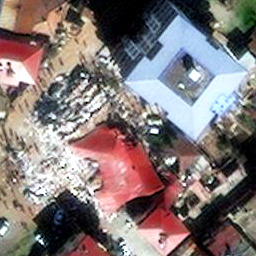
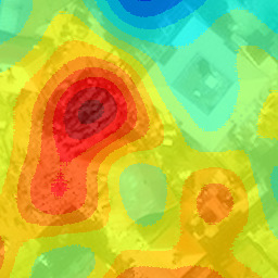
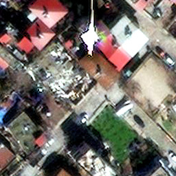

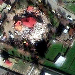
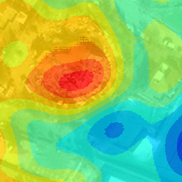
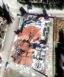


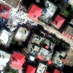

Collapsed building detections in south-east Turkey following the Feb. 6, 2023 earthquake.
Automated proposals of collapsed buildings are generated by a rubble detector followed by spatial aggregation.
Original images are property of Maxar Technologies, and are made publicly available under the Open Data Program
#satellite#remote sensing#artificial intelligence#builtup#machine learning#deep learning#ai#earthquake#turkey#rubble detection#rubble
23 notes
·
View notes
Text
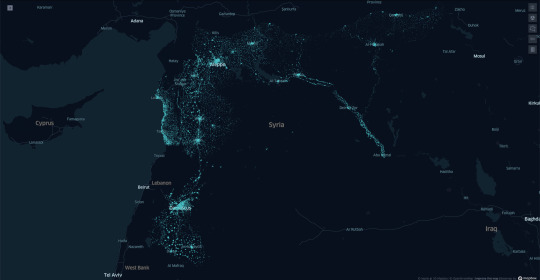
Syria, Atlas of Human Settlements, 2021
#syria#remote sensing#atlasofhumansettlements#atlasai#ai#deep learning#satellite imagery#settlement#earthquake
0 notes
Text
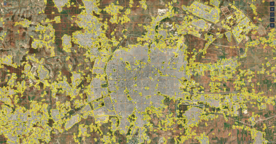
Aleppo, Syria 2021 - Atlas of Human Settlements @ Atlas AI
#aleppo#syria#earthquake#atlasofhumansettlements#atlasai#ai#deep learning#remote sensing#satellite imagery
0 notes
Text
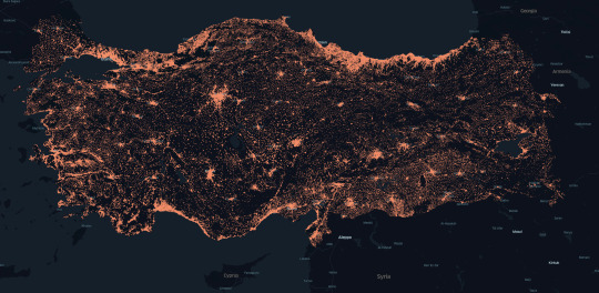


Atlas of Human Settlements @ Turkey & Syria
In response to the recent #turkeyearthquake & #syriaearthquake, we are proud to announce that our Atlas of Human Settlements (AHS) 2021 #datalayers for #Turkey and #Syria are now publicly available. The AHS data offers crucial intelligence for #crisismanagement bodies in their immediate efforts to respond to the #disaster, as well as to help inform the most #sustainableapproach to long-term rebuilding efforts.
Our AHS product is designed to help #response agencies answer questions such as: 1. Where were buildings clustered in the highest density before the incident? 2. Which clusters coincide with the highest population density? 3. How best to approach / access the densest built-up parts within settlements?
More information and free access to the AHS for #Turkey and #Syria can be found on #GoogleCloud’s Analytics Hub listing page at https://t.ly/MRWZ
You can read our full statement here: https://lnkd.in/dPUVxwFZ
Images above: Atlas of Human Settlements Map for Turkey (top), city of Aleppo in Syria, 2021
#turkey#earthquake#syria#atlasofhumansettlements#atlasai#ai#deep learning#remote sensing#satellite imagery#disaster response
0 notes
Text
Guangzhou is one of China’s fastest growing cities, its population more than tripling from 5 million in 1980 to 18.6 million in 2020. The city has seen a huge influx of migrants in recent years, spurred by its fast-growing economy and high labor demands. Guangzhou is at the heart of the Guangdong–Hong Kong–Macau Greater Bay Area, the most-populous built-up metropolitan area in the world with approximately 65.5 million residents.
23.130000°, 113.260000°
Source imagery: Google Timelapse
64 notes
·
View notes
Photo
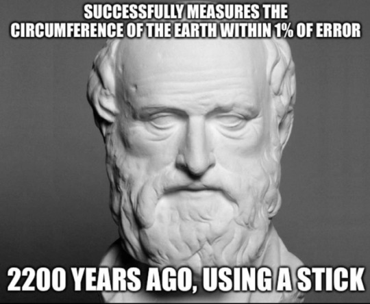
Eratosthenes of Cyrene
He is best known for being the first person known to calculate the circumference of the Earth, which he did by using the extensive survey results he could access in his role at the Library; his calculation was remarkably accurate. He was also the first to calculate Earth’s axial tilt, which has also proved to have remarkable accuracy. He created the first global projection of the world, incorporating parallels and meridians based on the available geographic knowledge of his era..
Read more: https://en.wikipedia.org/wiki/Eratosthenes
1K notes
·
View notes