#basemap
Explore tagged Tumblr posts
Visit Tumblr Blog
Explore Tumblr blogs with no restrictions, modern design and the best experience.
Last Seen Tumblr Blogs


Fun Fact
Women make up for the other 50% of Tumblr’s audience.
Text

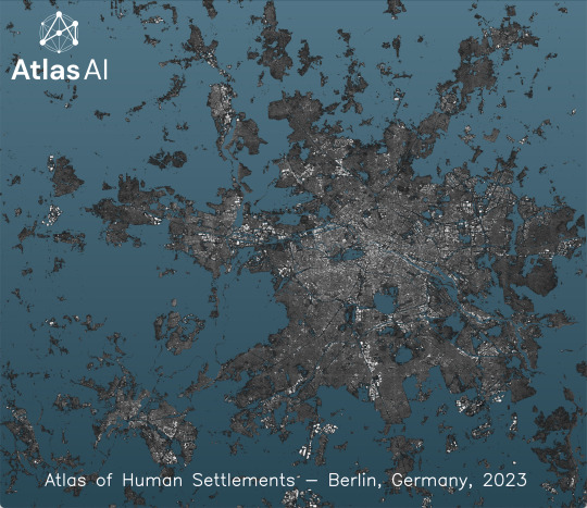
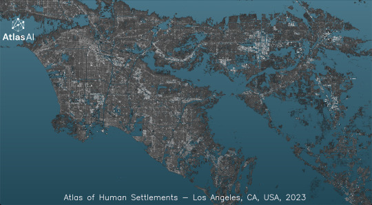
The Atlas of Human Settlements (AHS) v4.0 is just out!
AHS is built-up basemap of global extent, delivered at 10m spatial resolution and updated annually, with legacy layers going back to 2016. Version 4.0 features many quality improvements and additional raster and vector layers. Check it out in the official Atlas AI website at https://www.atlasai.co/ .
The images show the Built-up Index layer of major cities across the world.
#remote sensing#satellite#segmentation#atlasofhumansettlements#atlasai#deep learning#bigdata#georgios ouzounis#builtup#maps#basemap
3 notes
·
View notes
Photo


Tears of the Kingdom - Surface, Skies, Depths. Created using a heightmap extracted from Breath of the Wild, plus basemaps extracted from TotK, and some painting over in photoshop.
5K notes
·
View notes
Text
In 20 minutes I share everything I wish I knew before I started designing my permaculture food forest.
This video covers strategies for capturing and storing water, improving and feeding your soil, creating a baseman for capturing your observations, swales, contours, guilds and layering your food forest and working with succession as well as some syntropic agroforestry techniques that you can use in your backyard.
A permaculture food forest requires upfront work, but the long-term rewards are huge! That is why I believe it’s the easiest way to grow food. No annual tilling, no toiling under the hot sun year after year, no need to purchase inputs once your forest is established. Once you set up a successful system, it will thrive for generations to come.
Links mentioned in the video:
Want to experience the magic of Goldifarms? Visit our Etsy shop: https://www.etsy.com/shop/Goldifarms
The following are Amazon Affiliate links and I may receive a small commission if you purchase through these links:
Humanure Handbook by Joseph Jenkins
https://amzn.to/441FP9w
Restoration Agriculture by Mark Stepard
https://amzn.to/422yG7k
About Goldifarms:
My name is Erin. I started Goldifarms in my backyard in January 2020 as part of my journey to heal myself and restore this land. I follow permaculture design principles to create regenerative abundance here on the Central Coast of California in zone 9a. My intention with this YouTube channel is to provide inspiration to connect with nature, grow your own food and medicine, and help create a more beautiful world together.
Thank you for all your support, I hope these videos will inspire you to follow your heart and pursue what lights up your life ✨ 🌼💛
Sending so much love to you on your journey. Thank you for watching 🐝💛🌻
Want to experience the magic of Goldifarms? Visit our Etsy shop: https://www.etsy.com/shop/Goldifarms
For a brief history of Goldifarms, check out: https://www.youtube.com/watch?v=_u5z7...
For pics of the whole project, visit: https://www.instagram.com/goldifarms/
To learn more and contact Goldifarms, visit our website: Goldifarms.com
To support Goldifarms (which would mean the world to me!), you can become a Patron: https://www.patreon.com/goldifarms
If you never want to miss a Goldifarms video, subscribe by clicking here: https://youtube.com/goldifarms?sub_co...
For access to exclusive videos, consider joining my membership channel: / @goldifarms
Music from Epidemic Sound. If you create videos and are looking for a huge selection of music, feel free to use my epidemic referral for a free month: https://share.epidemicsound.com/hlg6dg
Chapters
00:00- Intro
00:33 - Start with Why
01:20 - Imagine
03:03 - Observe
04:09 - Create a Basemap
05:18 - Design for Water
09:45 - Get that GoldiGlow!!✨
11:04 - Feed your Soil
13:52 - Layers and Succession
18:38 - Design Iteratively
#Goldifarms#solarpunk#permaculture#food Forest#agriculture#how to#how to make#how to make a food forest#farming#garden#gardening
266 notes
·
View notes

Text
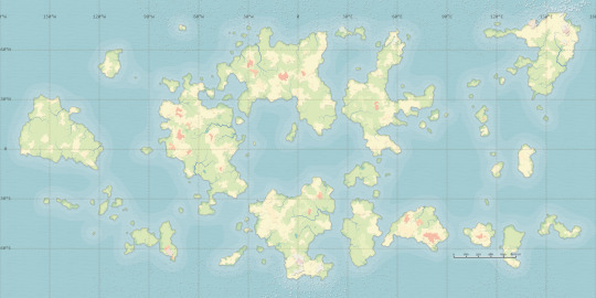
COMPLETE AUDIT OF MATERIALS IN FANTASY WORLD
BASEMAP

ROCK TYPE
REGIONS
METALS
IRON - 1
GOLD - 2
COPPER - 3
SILVER - 4
LEAD - 5

MIXED - 6 (Combination of Silver and Gold)

COBALT - 7
TUNGSTEN - 8
ALUMINUM - 9

SILICON - 10 (Combination of Copper, Iron, and Aluminum)

PEWTER - 11 (Combination of Iron and Lead)

CRYOGEN - 12 (Combination of Silver and Lead)

(Gems and Energy will be in the form of reblogs since tumblr only lets me add thirty images to a post)
60 notes
·
View notes
Note
What's the progress on Morrowind? I'm exploding with anticipation. Also, if you got the maps from somewhere, could you share them?
progress on the Morrowind chapter has been good—over 3k words in it so far!! (also lots on other chapters, including over 2k in the chapter for Anequina+Pellitine, and another 2k across the Black Marsh and Aldmeri Dominion chapters)
not totally sure re: your question about the maps. all my maps are my own work! i have a basemap of my own that i put together based on official maps like the anthology map, in-game map tiles, and some fan-made sources (e.g. i have a soft spot for Tamriel Rebuilt Morrowind, so the Morrowind on my Tamriel map is more similar to theirs than to official maps). i do have a few other map of mine that i haven't shared, but they're older ones that aren't as nice as my current work.
if you're curious, though, here's a super early WIP of the Morrowind map, without any of the actual languages put in it yet (and subject to change with cities and such):

#the elder scrolls#tes#ask#i also have a sketch of where the languages will be spoken#but that one is SUPER ugly#like blobs drawn on a map ugly#currently 23 dunmer langs in the doc#but i haven't even gotten to ashlanders yet
8 notes
·
View notes
Text
I was tagged twice! So I'm legally obligated to do this!
Tag game: tag 9 people you’d like to get to know better
Tagged by: @snowrassa and @queer-ragnelle
Last song: Ireland's 2024 Eurovision entry which (plot twist!?!?!) genuinely fucks so hard
Currently watching: My cat grooming herself in the window hammock
Three ships: Ummmm... if we go by ships that took up the greatest proportion of brainspace over the course of my life, it's probably Hector/Andromache, Phoenix/Edgeworth, and whatever Arthuriana flavored loyalty kink/wretched betrayal!!! scenario those girls have going on in Dreamcatcher's Deja Vu video.
Favorite color: Genuinely gray or silver. Occupation hazard of designing maps for work. I find ESRI's black and gray basemaps very visually soothing even when I'm uploading point data it and it automatically gives them these weird orange-red dots that are pretty ugly
Currently consuming: The coffee I just drank is converting to energy I guess?
First Ship: I think it was Zelda/Link in Ocarina of Time. My middle school self was just dumfounded by the epilogue where it pauses on them meeting for the first time again. Just totally flabbergasted and heartbroken that omg OG Zelda essentially annihilated herself by resetting time. Meanwhile Link is back in a happier past where he's the ONLY ONE who experienced all that horror. Even past Zelda is shut out of all that! I wanted the Zelda and Link who'd been through all that to find their way to each other again. And maybe kiss about it.
Relationship status: Single and ready to mingle /Karan Johar voice
Last movie: I think it was genuinely Sword in the Stone for the group watch. Really epic of that movie to just like... stop. Woops, if I waited until the evening to do this I could have said Past Lives!. ETA: HOW DID I FORGET I WATCHED NIGHT OF THE HUNTER YESTERDAY????
Currently working on: Two megamix projects. One is of the idol songs that spent the most time at number one in Korea in 2023. The other is a gidle megamix but I've been waiting to see the key signatures for the new songs at the end of January
Tagging: @lilyavara @onetrueharem @ladytaetae @amarguerite @ponydeathisland @targaryeirene @bookslifeandeverythingelse @aethelflaedel @bonos-grindcore-sideproject
8 notes
·
View notes
Text
(ooc: my one time playing battletech against a person was trying to teach friends using the starter box rules. We couldn't get mm to run so we had to use a PDF of a hex tile as basemap and small images as mechs, using Google slides to make it work.)
3 notes
·
View notes
Text
“Karalis” clef / keymap between 16^12 Angora & real-life Earth (Second Edition Preview, 11496 HE eq.)
PREFACE
Derived from the previous posts on the 16^12 constructed universe, soon to append additional content derived from books I own... (Looking especially towards Mark Rosenfelder's works but got a bunch more useful ones that aren't of his hand)
Yet to refine a bunch of specific details to emulate, to avoid / differentiate, and correlating the whole mess with a bunch of additional sources, files and documents to reach a satisfactory conclusion to this article.
Some fundamental key parameters to remember
Reason: Worldbuilding for filling in the lore behind my art and also for manifestation purposes
Motivation: Mental health, wish-fulfillment, feelings of accomplishment, historical exploration, personal improvement at the craft, nuanced political advocacy?;
Genre: Alternate history / parallel universe, adventure/mystery, far future, medium magick / psionics users, adult audience (Millenials + Zillenials + Gen Z);
Scale: Planet (focus points, smallest scale?)
Mood: Noble [Grim to Noble agency scale], Neutral-Bright [Dark to Bright lively comfort scale]
Theme: Coming of Age [cycles of constructive renewal every so often] (storytelling motifs)
Conflict: Political intrigue, ethics of knowledge, addventure exploration, data processing, progress vs preservation, internal + external conflicts;
Workflow: From blob map to detailed flat map to GIS+OSM-enabled map
Name: Try using meaningful, nuanced or at least representative names
Magic: Yes it exists, but high technology and other meta-physical matters take priority and by far.
Timescale: From ~16 billion years after the big bang to the late iron stars age of the universe (mostly focused onto the later time periods)
Civilization 5 & its planetary geography: A classical terrestrial planet (144x72 hexagonal tiles -> 288x144 hexagonal tiles? -> 2880x1440p basemap), Got Lakes? map script (to be expanded onto later), 5 Billion Years, Normal temperate, Normal rainfall, High Sea level, Abundant resources, Globe World Wrap, Tectonic Plates Mountains, 'Tectonic and chains' Extras, Small Continents Landmasses, Evergreen & Crop Ice Age & Full Ice Age, Tilted Axis Crop & Tilted Axis Full & Two Suns, enraged barbarians, random personalities, new random seed, complete kills, randomize resources & goodies, (planet with its associated divine realms heavily intertwinned with the living's physical plane?)
Mainline sapient species: Humans (Traditional humans yet with several more sub-species & ancestries, such as Otterfolk, Bearfolk, Mothfolk, Elkfolk, Selkie, Sabertoothfolk, Salukifolk, Hyenafolk, Tigerfolk, Boarfolk, Karibufolk, Glyptodonfolk, [insert up to four additional Cenozoic-inspired sub-species here]…), Automaton (constructs, robots, droids, synthetics…), Izki (butterfly folk), Evandari (rodent folk), Urzo (jellyfish-like molluscoid), Akurites (individualistic sapient anthropods), Ganlarev (sapient fungoid species), DAAR Hive Awareness (Rogue Servitor divided / disparate service grids)
Sideline sapient species: Devils, Hellhounds, Mariliths, Imps, Daemons, Valkyrie, Sphinx-folk, Angels, Cherubs, Thrones, Seraphims, Devas & Devi & Asuras, Fairy, Sprites, Dryads, Nymphs, Skinwalkers…
2D Ethos: [ Transparency - Mystery, Instrument - Agency; ] scales Threeway Ethical "Ancestral" Lineages: [ Harmony - Liberty - Progress; ] scale
Stellaris parameters: 4x Habitable worlds, 3x primitive civilizations, 4500s as contemporary present day, 4800s as Stellaris starting point, 5200 early game start, 5600 mid-game, 6000 late game, 6400 endgame / victory, all crisis types, tweaks to Stellaris' Nemesis system for extremely long-term lore (Neue Pangea Sol-3, Dying Sol-3, Undead Sol-3, Red Dwarves, Black Holes, Iron Stars, Heat Death;)…
FreeCiv parameters: [?]
SimCity 4 parameters: [?]
Life Simulation 'toybox' parameters: [?]
CRPG parameters: [?]
Computer mini-FS: [?]
Immersion and reality shifting feelies: [?]
Atlas parameters: [?]
[...]
CIVILIZATIONS
(12 majors, 32-48 minors, but it is a fairly flexible system as to leave room for many game scenarios and variations)
(Civ_1 to Civ_12) Shoshones (as the eponymous Shoshoni, also somewhat similar to the Western US of A + Cascadia + British Colombia to be frank), Maya (as the Atepec), Morocco (as the Tatari), Celts < Scotland < Gaelic Picts (as the Aberku), Brazil (as the March+Burgund+Hugues cultural co-federated group), Persia (as the Taliyan), Poland (as the Rzhev), Incas (as the Palche), Assyria (as the Syriac), Babylon (as the Ishtar), Polynesia < Samoa (as the Sama),
(Civ_13 to Civ_16) Korea (as the Hwatcha), Sweden (as the Mersuit), Japan ≈ Austria < Portugal (as the Arela), China ≈ Siam < Vietnam (as the Cao),
(Civ_17 to Civ_20) Indonesia < Inuit (as the Eqalen), Carthage (as the Eyn), Mongols < Angola (as the Temu), Netherlands (as the Treano);
(Civ_21 to Civ_36) Hungary (as the Uralic & Caucasus peoples, including Avars & Hungarians) Aremorica (as a different, more inner continental Gaulish Breton [or Turkey's Galatians], flavor of Aberku druidic Celts, from which the Angora names derives from) Sumer (some additional mesopotamian civilization into the mixture) Burgundy (as a releasable Occitan cultural state from Brazil) Lithuania (as the Chunhau cantonese seafarers) Carib (Classical Nahuatl / Nubian civilization of darkest skin cultures, integral part of a major human labor market before it got shutdown) Austria (as a releasable March cultural state from Brazil with some exiled cities) England (as a releasable Hugues cultural state from Brazil) Spain ≈ Castille ≈ Aragon (as the Medran) Nippur ≈ Nibru ≈ Elam (as another, east-ward mesopotamian state) Myceneans < Minoans (as a seafarers aggressive culture) Ethiopia < Kilwa ≈ Oman (as a Ibadi Islam outspot of trade) Venice < Tuscany (as another Treano state) Byzantium ≈ Classical Greece (as the pious religious orthodox Zapata government akin to tsarist Russia dynasty & Vatican Papal States during the late 18th century) Ottomans < Turks (as the Turchian turkic culture group) Hittites (as the Hatris / Lydians culture group)
CULTURES
(Ranges from ~36 to 48 total)
Eyn = Levantine
Ibrad = Hungarian
Zebie = Basque
Tatari = Berber
Cao = Vietnamese
Shoshoni
Turchian = Turkish
Eqalen = Inuit
Tersun = Ruthenian
Temu = Nigerian
Hugues = English
Lueur = Mongolian
March = German
Teotlan = Nahuatl
Hwatcha = Korean
Ishtar = Mesopotamian
Taliyan = Iranian
Palche = Quechua
Aberku = Celtic
Sama = Polynesian
Medran = Castillian
Burgund = French
Bantnani = Karnataka
Syriac = Mesopotamian
Atepec = Mayan
Rzhev = Ruthenian
Matwa = Swahili
Hangzhou = Chinese
Chunhau = Cantonese
Mersuit = Inuit
Treano = Italian
Arela = Portuguese
Hatris = Hittites / Lydians
Zapata = Byzantines / Mycenean Greeks
Nippir = Elam / Far-Eastern Mesopotamia
Irena = Minoan Greeks
STATES
(most likely much more than 96, and not yet decided either)
RELIGIONS
(~24 majors, 48 minors...)
Pohakantenna renamed as Utchwe (Shoshoni pantheon)
Confucianism tradition (and Shinto...)
Al-Asnam (Celtic druidic pantheon)
Ba'hai (monotheistic non-exclusive syncretism)
Arianism (iterated from the defunct Christianity dialect)
Chaldeanism (Mesopotamian pantheon)
Calvinism (derived from the Protestant Reformation's Huguenot Southern French, monotheism)
Tala-e-Fonua (Samoan pantheon)
Hussitism (central slavic dialect of monotheism)
Jainism (communal humility & individualized ki monks culture)
Buddhism tradition (inner way reincarnation & large monasteries)
Judaism
Zoroastrianism
Ibadiyya (Islam)
Shia (Islam)
Canaanism (Carthaginian belief system)
Pesedjet (Numidan Hieroglyphics belief system)
Mwari (Carib religion)
Inti pantheon
Mayan pantheon
Political Ideologies
Harmony (right-wing preservationist / "conservative" party, with very limited Wilsonism involved due to historical failings, so like a mixture of Democrats and Republicans as a Unionist Party)
Progress (think of the Theodore Roosevelt progressives party...)
Liberty (political center party)
Syndicalism (alternate development & continuation of IRL marxism, leninism, maoism, trotskyist "new-left" and the other left-wing doctrines of the socialism / communism types)
Georgism / ( "One Tax" + Ecological movement )
Classical Liberalism (aka open-choice Libertarians with brutal constructivist modular views of the world perhaps?)
Philosophies
[ Yet to be really researched and decided ]
Historical equivalences & differences
Mersuit emulating the history of Sweden.
Shoshoni as something somewhat similar to a developed amerindian old westerns' United States of America...
Widespread appeal of Asetism (Monasteries, humility and introspection, likewise to Jains and Buddhists) & Taizhou (Tala-e-Fonua equivalent) as key major worldly religions
No Woodrow Wilson, progressive major successes in the 1910-1945 equivalent.
More long-term sustainable and successful generational pathway in the 1960s-2000 period, still leading to a slow partial ecological collapse like in the Incatena reality just about around the mid 2045-2050 period with signs of decay arising from the 2020s. So the sapient peoples are more cooperative and empowered with the people that era and won't see as much of the managerial crisis sparks until the mid-2020s.
The global pandemic hit during the early 2000s alongside the dawn of ecological issues coming ahead (giving a slight headstart to fully figure problems coming not that far ahead), just around the time of nanotech synthetic autonomous androids emergence and a handful of alternatively successful technical progressions making them a slight bit ahead of ours on a couple fields. No mainstream autonomous governance AI service grids or really crazy Sci-fi innovations just yet, but a fair share of orphaned developments we did not have continue in this world.
A couple of benevolent worker cooperatives like Pflaumen (DEC+ZuseKG), EBM (IBM+ICL) & Utalics (Symbolics+Commodore+GNU Foundation)... continue well into the 21st century and persist as major computation players in the tech industry, averting the immediate rise of Macroware (Microsoft), Avant (Google) & Maynote (Meta) by the ill-conceived social medium strategy.
[ More to be written... ]
POSTFACE
All may be subject to heavy changes still (but especially everything global map related), so take it with a large pinch of salt, please. Thanks for reading btw and farewell to soon!
3 notes
·
View notes
Text
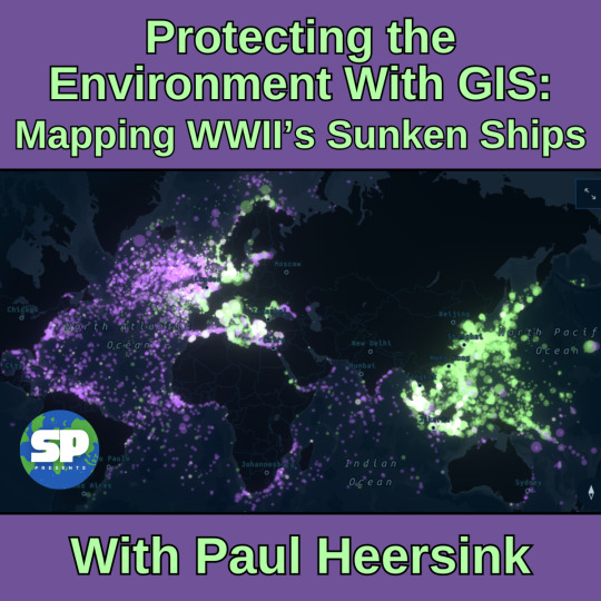
Protecting the Environment With GIS: Mapping WWII's Sunken Ships with Paul Heersink
This week, Ariel interviews Paul Heersink about his project mapping the sunken ships of WWII, and how this information can help environmentalists, salvagers, families of the deceased, and treasure hunters! Come join us as we explore sunken potential.
This week, Ariel chats with Paul Heersink, cartographer and Program Manager for the Roads and Addresses program at ESRI Canada. Formerly, he was Production Manager of the Community Maps Program: an initiative that is aiming to build a seamless topographic basemap of Canada using contributor data, and the Roads and Addresses program aims to do the same with community-sourced data, building a…
View On WordPress
#Bismarck#DH#digital data#digital humanities#ecology#environmentalism#ESRI Canada#GIS#mapping#maps#ocean#oil#reclamation#Roads and Addresses#salvage#solarpunk#solarpunk presents podcast#World War Two#WW2#WWII
3 notes
·
View notes
Text
Flood Risk Mapping Using Interactive Web Maps: A SaaS Platform Approach

An interactive SaaS-based online map-based method for mapping flood risk. Real-time data visualization, risk analysis, and decision-making support are all made easier by the platform. Through the use of cloud computing and geospatial tools, it enhances accessibility and collaboration in flood risk management for planners, governments, and communities.
For Flood Risk Mapping, Why Use an Interactive Web Map-Based Software as a Service Platform?
Without the need for complex infrastructure, SaaS systems provide scalable, reasonably priced flood risk mapping solutions that enable users to view data, assess risks remotely, and collaborate to enhance decision-making, prepare for emergencies, and ensure continuous updates.
A SaaS Platform Approach to GIS Applications for Interactive Web Maps in Flood Risk Mapping
Using a SaaS platform to map flood risk requires Geographic Information Systems (GIS) since they enable:
The process of combining hydrological, topographical, and meteorological data for in-depth analysis is known as data integration.
The practice of using spatial trends to identify persons and regions at risk is known as risk assessment.
Decision Support: Giving planners and emergency responders useful information.
Public Engagement: Developing user-friendly interfaces to assist communities in understanding the risks associated with flooding.
Using Interactive Web Maps to Map Flood Risk:
The three primary applications of interactive web maps for mapping flood risk are as follows:
Aids in emergency response planning: identifying high-risk areas, devising efficient evacuation routes, and resource allocation.
Supports engineers in developing resilient infrastructure and zoning laws in flood-prone areas.
Encourages community involvement and public awareness: providing easily understandable flood risk information.
Flood Risk Map Generation with Interactive Web Maps
This technique explains how to use an interactive online map SaaS platform to generate flood risk maps.
Create a hybrid basemap with unique river and border layers.
Create buffer zones around rivers to show flood affected areas.
Style each layer for clarity.
Deliver scalable, real-time analysis in flood-prone locations.
Improve public awareness, emergency planning, and informed decision-making.
UseCase: Urban Planning and Infrastructure Resilience – Flood risk maps inform land-use planning by overlaying floodplain data with zoning and infrastructure layers, enabling planners to design resilient urban systems, enforce building codes, and mitigate future flood impacts through strategic development.
Open-source web application for making maps
Open-source tools like MAPOG are reshaping flood risk management by offering interactive online maps powered by dynamic mapping, cloud access, and strong data analytics. This flexible platform supports preparedness, strengthens communities, and enables faster emergency response. With intuitive buffer tools, users can easily create clear, impactful flood maps for planning and analysis.
Conclusion
Buffer distances provide a clear way to visualize proximity and risk. When applied correctly, they support better planning, safety assessments, and environmental decision-making in various fields like urban development or disaster response.
#FloodRiskMapping#SmartMapping#DisasterPreparedness#SaaSMapping#GeospatialTech#InteractiveMaps#MAPOG#ClimateResilience#EmergencyResponse#DataDrivenPlanning#UrbanResilience#FloodAwareness
0 notes
Text
Tinting basemaps to match your #ArcGIS dashboard theme
https://www.esri.com/arcgis-blog/products/ops-dashboard/analytics/tinting-basemaps-to-match-your-dashboard-theme/
0 notes
Text
How to Geocode Excel Data into a Map?
Introduction
Turning raw Excel data into a visual map can be a game-changer for businesses, researchers, and urban planners. Whether you need to analyze sales territories, track deliveries, or study demographic trends, mapping your data helps unlock insights that spreadsheets alone can't offer. This article will walk you through the process of geocoding Excel data and transforming it into an interactive map.

What is Geocoding?
Geocoding is the process of converting addresses or place names into geographic coordinates (latitude and longitude). Once geocoded, this data can be visualized on a map for better spatial analysis.
Steps to Geocode Excel Data
1. Prepare Your Data
Before uploading your Excel file, ensure it contains:
Address fields (Street, City, State, ZIP Code, Country) OR latitude & longitude columns.
A clear and consistent format without duplicate entries.
2. Use an Online Geocoding Tool
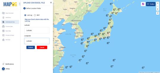
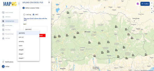
Several platforms offer geocoding services where you can upload Excel files and generate maps. Pick one such tool allows users to geocode their data seamlessly like MAPOG, making mapping a hassle-free experience.
3. Upload and Process Your File
Import your Excel file (.csv or .xls format).
Map the appropriate columns to ensure accuracy.
Run the geocoding process, which assigns latitude and longitude to each entry.
4. Visualize Your Data on a Map
Once geocoded, your data points will appear on an interactive map. You can customize it by:
Changing basemaps (road, satellite, hybrid views).
Applying color-coded categories for better analysis.
Adding additional attributes like time zones, demographics, or custom fields.
Real-World Applications of Geocoded Maps
Business & Sales Tracking
Companies can map customer locations to optimize delivery routes.
Sales teams can analyze which regions have the highest conversions.
Urban & Environmental Planning
City planners can study population density and infrastructure needs.
Environmentalists can track pollution sources and their impact zones.
Healthcare & Public Services
Hospitals can map patient distributions to allocate resources efficiently.
Emergency responders can analyze risk-prone areas for better preparedness.
Tools to Explore
Platforms like MAPOG provide useful tools for geocoding and mapping. The Upload CSV-Excel tool is specifically designed to help users transform spreadsheet data into actionable maps while supporting formats like CSV, XLSX, XLS, ODS . If you're looking for a user-friendly, powerful way to visualize data where you can upload both latitude, longitude and WKT data, it's worth exploring.
Conclusion
Geocoding Excel data into a map can simplify complex datasets, reveal patterns, and enhance decision-making. Whether you're in business, urban planning, or research, mapping your data brings it to life.
Ready to get started? Try out mapping tools and see how geocoding can elevate your workflow!
0 notes
Text

I am frustrated because I have reached the limit of my ability to get the the basemap to piece together properly — Nebraska and Missouri are falling apart, the South is falling apart. It seems to be perhaps a combination of the scan losing space as the pages meet the binding (I am sure this is happening) and perhaps also slight adjustments in the underlying projection (I am less certain about this, but it would make me feel better because otherwise my stitching has been severely suboptimal.) The task is an obsessive-compulsive terror, and, my godhead evidently being nearsighted, the names of my towns have in many cases noised into nothing.
I am frustrated also by the prospect of tomorrow's labor; and I am wishing it was significantly more possible to get a job in which research (or artificial skills in general) was a valued component; I am tired of the service economy, tired of the institutional pathways which seem to me like a boring closed-world grinding task, tired of rejection letters (many weeks later coming) noting that my background is very impressive (but...), tired of being managed. It is one thing to be constrained by sleeping and feeding, and movement and repose, and quite another to be herded through the social machines inherited to us as a congenital sickness: at a dreamworld teatime, relations crowd the table and lecture me: you are stooped under our ceilings, and slow to handle our figures: you are more stupid than we were, though perhaps with senses more sensitive to variegation — and you stupider for it;.
Nebraska and Missouri are falling apart; the South is falling apart. At every instant the stars above are farther away: the people more vile, the food more bland, the words duller and more obvious, the feeling more despicable.
0 notes
Text
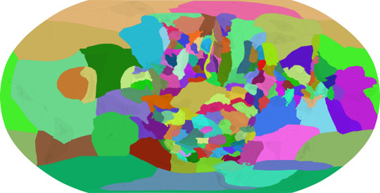
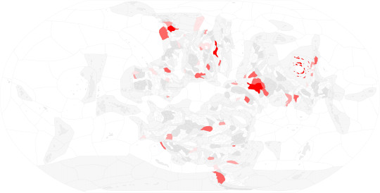
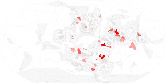
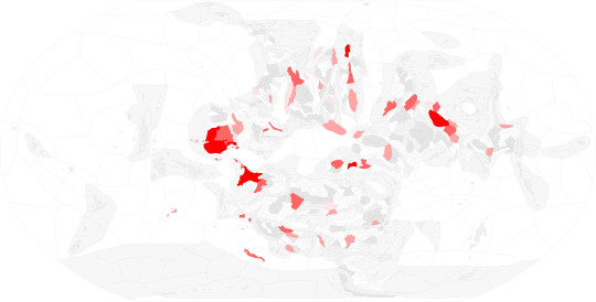
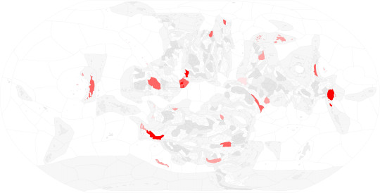
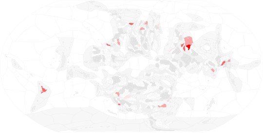
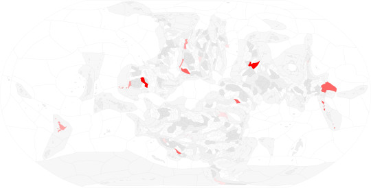
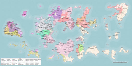
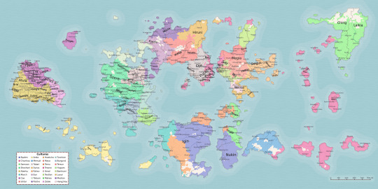
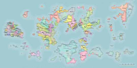
All 1296 individual mineral deposits for my conworld in a map and an itemized list :)
I'll be using both to reverse engineer the tectonics of my world, since if I know there is coal in an area, I know that at one point it was at or near the equator.
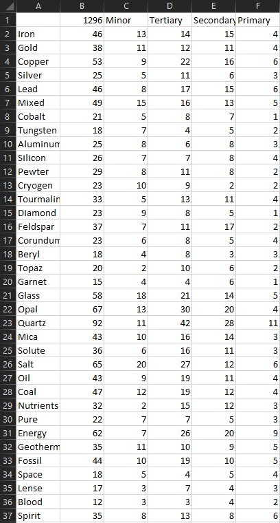
Also here is the basemap I am working off of, there are about 15 major regions, 51 regions, and 172 subregions, the subregions are labeled, and there are two maps below it showing the makeup of the major's and regions.
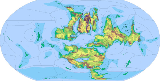
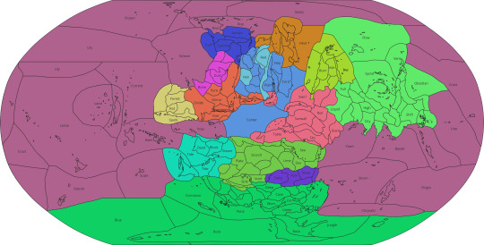

Feel free to ask for clarifications RE: Mineral definitions or Regional phenomena 😎👍
33 notes
·
View notes
Note
It's going to be a political map, like for elections. If you have one with an intact Vivec that would be great, but that shouldn't be too hard to fix.
ooh, cool!!! given the intact Vivec, i figure this is pre-Red Year, so here are a pair of Morrowind basemaps with pre-Accession War borders, too:


one with rivers + lakes and one without! hope these help!!
#the elder scrolls#tes#ask#morrowind#i should really make a new tamriel map#or at least finish my morrowind map
6 notes
·
View notes