#Ōkārito
Text

(by Nick Da Fonseca)
#vertical#landscape#x#a#watsf#curators on tumblr#ocean#water#Nick Da Fonseca#coast#cliff#waves#New Zealand#Ōkārito#Okarito
836 notes
·
View notes
Text
More countries with what Pokémon type they'd specialise in if they were gym trainers and Pokémon I think they'd have if they were regular Pokémon trainers. A thread:
Australia:
Given the number of dangerous animals in the country as well as the stereotypical joke of "everything wants to kill you in Australia", I can see Australia being a poison type gym leader! (Note, I did consider bug type for him).
The gym would take place in a rainforest. You'll be given a map, compass along with other necessities at the start of your challenge. You must navigate your way through the rainforest, battling trainers along the way, while being tasked with collecting five small tokens before you battle Australia. When you reach Australia, he is located in front of a waterfall (inspired by Wallaman Falls). Once you defeat him, Australia will gift you some antidotes and invite you to go swimming with him.
Australia's potential poison type team: Toxapex, Naganadel, Toxtricity (Amped form), Nihilego and Drapion.
Australia's varied Pokémon trainer team: Komala (a reference to Australian wildlife and the Koala that canonically is by Australia' side), Corsola (reference to the Great Barrier Reef), Mantine (reference to the popular sport of surfing in the country) and Galvantula (reference to the spider population in Australia).
New Zealand:
Given the beautiful southwest pacific ocean that surrounds New Zealand as well as the practice of surfing, boat sailing and the numerous lakes and rivers in the country, I can see New Zealand being a water type Pokémon gym leader.
His gym would be located within a costal lagoon (inspired by Ōkārito lagoon). The challenge for the trainer prior to battling will be herd sheep in a nearby field for a distressed farmer (reference to the sheep population in the country). Once you've completed this, you'll enter the lagoon and battle New Zealand. When you've defeated New Zealand and earned your badge, he'll gift you a bottle of wine if you're of age (reference to New Zealand's wine) or a can of soda if you're underage and ask if you'd like to watch some rugby with him.
New Zealand's potential water type team: Golduck, Gyarados (Mega), Whiscash, Floatzel, Barbaracle and Araquanid.
New Zealand's varied Pokémon trainer team: Wooloo (another reference to New Zealand's sheep population), Machamp (I envision this Pokémon to be useful during Rugby training, referring to New Zealand's famous Rugby team), Palossand (reference to New Zealand's beaches) and Impidimp (reference to The Hobbit series).
America:
Given America's personality, his desire to be everyone's hero and obsession with super hero films jot to mention his fighting skills and strength we've seen in the manga, anime and film; I think it's sage to say I can see America as a fighting type gym leader.
Now for his gym, I see two options:
1. The gym is located in a mock "wild west" area (reference to American cowboys and American frontier) where the trainer is tasked with shooting all the tin cans from shooting area and clay pigeon shooting, whilst of course battling appropriately dressed trainers along the way. America is located in the sheriff's house which when you ender, is a gym. Once you beat America and earn your gym badge, he'll take you to McDonald's. And yes he will film this like a movie for his social media.
2. You're in a filming studio which is set up for an action movie. Your job is to battle the trainers here, who are dressed as villians, and defeat all five of then before progressing onto the final battle with America. America will battle you at the center of the studio, surrounded by a backdrop of New York City and numerous props, dressed in a super hero costume (don't worry, the trainer gets a costume too), while your battle is filmed for America's social media. Once you beat America and get your gym badge, he'll take you to McDonald's (see above).
America's potential fighting type team: Machamp, Blaziken (Mega), Hariyama, Urshifu single strike, Hawlucha and Lucario.
America's varied Pokémon trainer team: Shiny Braviary (reference to America's national animal being the bald Eagle), Rotom (since I can see America being quite addicted to social media and also technology saavy, I feel Rotom and its many forms are a fit here), Plusle and Minun (reference to American Cheerleading) and Revavroom (reference to American dominance historically in the automotive industry).
Canada:
Given how one of the things Canada is known for is Ice Hockey and the fact that Canada experiences snow and ice for several months during the year, I can totally see him as an ice type gym leader.
Building on that ice hockey reference, I feel his gym would be inside of an ice hockey arena. There's a game going on, but no one can find the player's ice hockey sticks and so you are tasked with finding all of the ice hockey sticks before the game starts. Once you've completed this you'll face Canada on the ice. When you've beaten him and obtained your gym badge, he will invite you to have some pancakes with maple syrup with him.
Canada's potential ice type team: Galarian Mr. Mime, Avalugg, Abomasnow, Glaceon (ice tera), Dewgong and Alolan Sandslash.
Canada's varied Pokémon trainer team: Cubcoo (reference to Kumajirou), Bidoof (reference to Canadian wildlife), Mudsdale (reference to the Royal Canadian Mountain Police) and Alcremie vanilla cream star sweet (this sweet Pokémon has been selected to refer to Canadian Maple Syrup).
0 notes
Text
RNZ Pacific 1340 26 Mar 2023
7440Khz 1259 26 MAR 2023 - RNZ PACIFIC (NEW ZEALAND) in ENGLISH from RANGITAIKI. SINPO = 44344. English, QRM=CRI(?) cochannel. s/on w/bellbird int. until pips and news @1300z anchored by Peter McIlwaine. British gender activist Posie Parker has left New Zealand, calling it the 'worst place for women she has ever visited'. Kellie-Jay Keen-Minshull, also known as Posie Parker, shared a photo on social media showing her being escorted by police through Auckland Airport. She left her rally at Albert Park in Auckland yesterday without speaking, after being overwhelmed by thousands of heckling counter-protesters and pelted with tomato juice. National Party leader Christopher Luxon says a controversial British activist has the right to free speech in New Zealand, following the clash at Auckland's counter protest on Saturday. The #MARANGA – Rise up Aotearoa national relief concert has raised more than $700,000 for whānau and communities devastated by Cyclone Gabrielle. Hawks Bay to host controversial "stop co-government" event. The Stop Co-Governance Tour has already attracted protests and controversy for its likening co-governance to apartheid. Once again volunteers from around the country will head to South Westland to fight the invasive gorse threatening to overrun the picturesque Ōkārito Lagoon. A group of Taranaki students have been getting up close and personal with a piece of technology that detects urine patches on farm pasture - and sprays it with nitrogen inhibitor. Sports. @1303z trailer for RNZ "Morning Report". @1304z Weather Forecast: Fine spell, isolated showers, some thunderstorms. @1306z "All Night Programme" anchored by Peter McIlwaine. Backyard fence antenna, Etón e1XM. 100kW, beamAz 35°, bearing 240°. Received at Plymouth, United States, 12912KM from transmitter at Rangitaiki. Local time: 0759.
0 notes
Text
Wir besprechen acht Kurzwanderungen auf der Südinsel, die Neuseelands außergewöhnliche Landschaft in nur einem kurzen Spaziergang zeigen
Wenn Sie keine Zeit oder Beine für die Great Walks of New Zealand haben, dann sind diese kurzen Spaziergänge auf der Südinsel das Nächstbeste. Mit grandiosen Ausblicken, die manch Fernwanderweg in nichts nachstehen, zeigen diese schnellen Wanderungen das Beste von Neuseelands vielfältiger und manchmal bizarrer Landschaft ohne schmerzende Füße, verschwitzte Rücken und schlammige Stiefel.
Kurze Spaziergänge auf der Südinsel
Alle diese kurzen Spaziergänge auf der Südinsel sind gut gepflegt und gut ausgeschildert, mit einfachem Zugang und Parkplätzen in der Nähe. Sie sind ideal für diejenigen, die die Südinsel mit dem Auto oder Wohnmobil bereisen.
Gehweg der Kaikoura-Halbinsel
Entfernung: 11,7 km Dauer: 3 Stunden Weitere Informationen: doc.govt.nz
Atlas & Boots Neuseelands Südalpen treffen auf den Pazifischen Ozean
Bei Kaikoura treffen Neuseelands Südalpen auf dramatische Weise auf den Pazifischen Ozean. Die Halbinsel ragt aus der zerklüfteten Ostküste der Südinsel heraus und verfügt über einige hervorragende Aussichtsplattformen auf den Klippen. Im Rücken der schneebedeckten Seaward Kaikoura Range ist dies ein wunderbarer Ort, um eine Reihe von Wildtieren zu beobachten, darunter Wale, Delfine, Pelzrobben, Pinguine und Albatrosse.
Die gesamte Wanderung kann bis zu drei Stunden dauern und Sie können sie verlängern oder verkürzen, wenn Sie möchten. Der beste Ausgangspunkt für die Wanderung ist Point Kean, aber die vollständige Wanderung kann in der Gemeinde South Bay oder West End beginnen.
Lake Matheson / Te Ara Kairaumati-Wanderung
Entfernung: 2,6 km Dauer: 1 Stunde Weitere Informationen: doc.govt.nz
Atlas & Boots Eine der ruhigsten Aussichten in Neuseeland
Mein Favorit unserer kurzen Wanderungen auf der Südinsel zeigt die höchsten und zweithöchsten Berge Neuseelands. Aoraki / Mount Cook auf 3.724 m (12.218 ft) und Mount Tasman auf 3.497 m (11.473 ft) erheben sich über den ruhigen, reflektierenden Gewässern des Lake Matheson und bieten eine der Postkarten-perfektesten Aussichten in ganz Neuseeland. Beide Gipfel können aus allen Blickwinkeln in dem ruhigen See gespiegelt gesehen werden, der sich inmitten üppiger und uralter Wälder befindet.
Ōkārito Trig Walk
Entfernung: 4,2 km hin und zurück Dauer: 1 Stunde Weitere Informationen: doc.govt.nz
Atlas & Boots Der Trig Walk ist einer von mehreren Wanderwegen rund um die Lagune von Ōkārito
Nur wenige Kilometer nördlich des Franz-Josef-Gletschers liegt die Küstensiedlung Ōkārito und die Ōkārito-Lagune. Es gibt mehrere Wanderwege in der Gegend, aber wir haben uns für den Trig Walk entschieden, der einen Teil des Wetland Walk über die Lagune umfasst.
Der Trig Walk ist eine kurze, aber anstrengende Wanderung zu einem Aussichtspunkt, wo Sie ein atemberaubender Panoramablick über das umliegende Meer, die Mündung, die Klippen, den üppigen Wald und natürlich die Südalpen erwartet.
Franz-Josef-Gletscher / Kā Roimata oder Hine Hukatere Walk
Entfernung: 5,4 km Dauer: 1-2 Stunden Weitere Informationen: doc.govt.nz
Atlas & Boots Franz-Josef-Gletscher am Ende der Talwanderung
Der Franz-Josef-Gletscher liegt im Westland-Tai-Poutini-Nationalpark an der Westküste der Südinsel und erstreckte sich einst von den Bergen bis zum Meer. Nach Jahrtausenden des Rückzugs liegt der Gletscher nun 19 km landeinwärts und ist nur per Helikopter erreichbar. Die Heli-Wanderungen werden oft wegen schlechten Wetters abgesagt, daher ist der nächstbeste Weg der Valley Walk zu einem Aussichtspunkt in der Nähe der Endwand.
Lesen Sie hier unseren vollständigen Bericht über die Wanderung: Kampfwetter am Franz-Josef-Gletscher.
Moeraki Boulders Walk
Entfernung: 1 kmDauer: 30 MinutenWeitere Informationen: doc.govt.nz
Atlas & Boots Moeraki Boulders, eine Gruppe kugelförmiger Felsen am Koekohe Beach am Otago
Die Moeraki Boulders sind eine Ansammlung nahezu perfekter
kugelförmiger Felsen, die entlang des Koekohe Beach an der Küste von Otago verstreut sind. Diese etwa zwei Meter breiten und mehrere Tonnen schweren Konkretionen sind nach der Erosion der darüber liegenden Küstenklippen ins Meer gestürzt. Felsbrocken werden weiterhin freigelegt, wenn Wellen den Schlammstein wegspülen, der sie in die Klippen einbettet.
Die Felsbrocken sind nur einen kurzen Spaziergang hinunter zum Strand und entlang der Küste vom Parkplatz entfernt, wo sich ein Café mit hervorragendem Blick auf die Küste befindet.
Blue Pools-Track
Entfernung: 1,5 km Dauer: 1 Stunde Weitere Informationen: doc.govt.nz
Traumzeit Die Süßwasserpools in der Nähe von Makarora
Abgeschieden in den Tiefen eines ruhigen Buchen- und Podocarp-Waldes befindet sich eine Ansammlung kristallklarer Becken mit tiefem, eisigem Wasser. Die ruhigen Pools münden in den Fluss Makarora, wo zwei Drehbrücken eine hervorragende Aussicht bieten. Es ist möglich, die Brücken zu überqueren und den Weg weiterzugehen, um die Aussicht entlang der Schlucht zu genießen.
Die kürzlich restaurierte Strecke liegt am Haast Highway etwa 20 Minuten westlich von Makarora.
Pancake Rocks und Blowholes Walk
Entfernung: 1,1 kmDauer: 30 MinutenWeitere Informationen: doc.govt.nz
Atlas & Boots Die Punakaiki Pancake Rocks am Ende des Weges
Die Pancake Rocks und Blow Holes in Punakaiki markieren das Ende des bald 10. Great Walk of New Zealand. Der Paparoa and Pike29 Memorial Track wird 2019 eröffnet. Die kuriosen Kalksteinformationen, die sich neben der wilden Tasmanischen See befinden, sind bei Flut am spektakulärsten. Die Route ist durchgehend mit Holzstegen mit mehreren Aussichtspunkten und Hinweisschildern versehen.
Der Abgrundweg
Entfernung: 1 kmDauer: 30 MinutenWeitere Informationen: doc.govt.nz
Atlas & Boots Gletscherwasser fließen durch The Chasm
Nachdem wir morgens den nahe gelegenen Milford Sound erkundet hatten, machten wir Halt bei The Chasm. Der kurze Spaziergang überquert zwei Fußgängerbrücken über den Fluss Cleddau mit spektakulärem Blick auf eine Reihe von Wasserfällen. Das schnell fließende und wirbelnde Wasser hat über Jahrtausende runde Formen und Becken in den Felsen gemeißelt, was für eine dramatische Szene im üppigen Wald sorgt.
Suchen Sie etwas länger? Mit Geschichten von 50 unglaublichen Wanderrouten in 30 Ländern wird Lonely Planets Epic Hikes of the World zu einem lebenslangen Abenteuer zu Fuß inspirieren.
Hauptbild: Atlas & Boots
.
#New_Zealand#Ozeanien#Aussicht#Berge#kurze#Spaziergänge#Südinsel#Tageswanderungen#toller#Wandern_Trekking
0 notes
Photo
Female Tomtit - Ōkārito, New Zealand
Source: https://bit.ly/3pQZ6Ge
119 notes
·
View notes
Video

flickr
White heron, (Egretta alba modesta) by Bernard Spragg. NZ
Via Flickr:
The white heron has always been rare in New Zealand and it has gained almost mythical status. It is revered by both Māori and pakeha for its elegant white feathers. This graceful bird has long, slender legs and a long, thin S-shaped neck, which has a distinct kink when flying. The kōtuku is common in Australia, the South Pacific and Asia. In New Zealand it only breeds near Whataroa, South Westland, between September and January. This colony is in the Waitangiroto Nature Reserve and guided jet boat tours take visitors to view the birds from an observation hide. During the breeding season time, the birds feed in the large coastal lagoons in the area, particularly the nearby Ōkārito Lagoon. After breeding, the birds disperse widely and may be seen at coastal freshwater wetlands or estuaries throughout the country.
7 notes
·
View notes
Text
Hector's dolphin calf found dead on West Coast
Hector’s dolphin calf found dead on West Coast
A dead Hector’s dolphin calf has been found by a member of the public in the West Coast’s Ōkārito Lagoon.
Maternal separation has been cited as a possible cause of death for some of the Hector’s dolphin calves found dead around the South Island this summer.
Photo: Supplied
It is the eleventh Hector’s dolphin found dead around the South Island since last November, eight of which were…

View On WordPress
0 notes
Photo

New Post has been published on https://travelonlinetips.com/epic-hiking-on-new-zealands-south-island-lonely-planets-travel-blog-2/
epic hiking on New Zealand’s South Island – Lonely Planet's travel blog
New Zealand is home to nine ‘Great Walks’: premier hiking tracks that pass through the country’s most spectacular scenery. The South Island in particular offers some the finest hiking in the world. We spent two weeks touring the island to get a taste of these pristine trails, several of which are featured in Lonely Planet’s Epic Hikes of the World.
Here are some of our hiking – or as the locals call it, ‘tramping’ – highlights.
Our first view from the Abel Tasman Coastal Track
The Abel Tasman Coastal Track is peppered with vistas like this along its 60km of oceanside trail. Located in the Abel Tasman National Park, the trail is named after Dutch seafarer Abel Janszoon Tasman, the first known European to reach New Zealand during his voyage of 1642.
A secluded cove on the Abel Tasman Coastal Track
The Abel Tasman National Park boasts golden beaches, clear waters and lush coastal native bush – ideal terrain for long-distance hiking. The total trail length is around 60km (2-3 days), but we only had time for a brisk 13km during our half-day hike.
The boardwalk of the Ōkārito Trig Walk
Just north of Franz Josef Glacier sits the coastal settlement of Ōkārito and the Ōkārito Lagoon. The Trig is a short but vigorous walk up to a lookout of sweeping views: a panoramic vista across the surrounding ocean, estuary, sea cliffs, lush forest and, of course, the Southern Alps.
Crossing the Routeburn Flats in Mount Aspiring National Park
We completed a section of this classic New Zealand hike as part of our active tour with G Adventures and Lonely Planet. The 32km alpine track follows the Routeburn River for 15km through ice-carved valleys beneath the majestic peaks of the Southern Alps.
A perfect place to pause for a picnic
We arrived at this picturesque picnic spot halfway through our hike of the Routeburn Track. Situated in the shadows of the Humboldt Mountains is the Routeburn Flats Hut, a popular bunkhouse and camping site for hikers. It also offers captivating views across the valley floor.
Perhaps the finest view in all of New Zealand?
The short but sweet hike around Lake Matheson in Westland Tai Poutini National Park provides one of the finest views in all of New Zealand. The reflective, still waters make for stunning views of New Zealand’s highest mountains: Aoraki / Mount Cook at 3724m and Mount Tasman at 3497m.
Lace up your boots and hit the tracks of the planet’s greatest walking trails, with our new title Epic Hikes of the World.
Source link
0 notes
Text
Ranger, Operations - Department of Conservation - Franz Josef
Ranger, Operations – Department of Conservation – Franz Josef
Are you someone who loves the outdoors, has lots of practical skills and enjoys working with people? If yes, then this is the job for you.
We are looking for a Ranger, Operations (Biodiversity) to be based at Franz Josef.
The focus of this position is to carry out rowi (Ōkārito Brown Kiwi) recovery work, and other biodiversity related work in South Westland. We are looking for someone to join our…
View On WordPress
0 notes
Text
Hector's dolphin calf found dead on West Coast
Hector’s dolphin calf found dead on West Coast
A dead Hector’s dolphin calf has been found by a member of the public in the West Coast’s Ōkārito Lagoon.
Maternal separation has been cited as a possible cause of death for some of the Hector’s dolphin calves found dead around the South Island this summer.
Photo: Supplied
It is the eleventh Hector’s dolphin found dead around the South Island since last November, eight of which were…

View On WordPress
0 notes
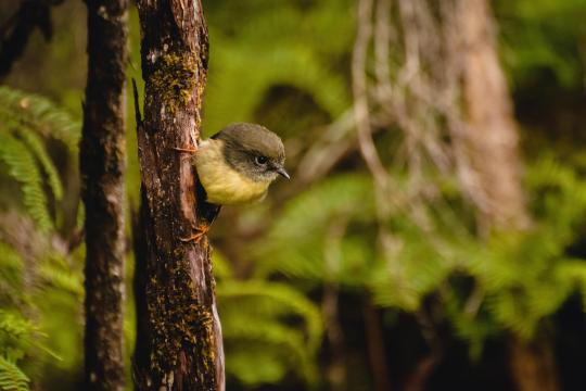
Photo

Male Tomtit - Ōkārito, New Zealand
Source: https://bit.ly/3hItjop
0 notes
Last Seen Blogs

twopoppies
Be a lover. Give love. Choose love.
mrachnyie
𝙏𝙃𝙄𝙎 𝘿𝘼𝙍𝙆 𝙄𝙎 𝘿𝙀𝙀𝙋.

helenal4real-blog
Architecture

akosibhon-blog
Earl Root | Photography

petrika-stark-parker
Starlight