#Azimuth 144
Video
Pinnacles National Park...Another Ultimate Stress Escape by Mark Stevens
Via Flickr:
A setting looking to the southeast while taking in views up a hillside to volcanic leftovers and rock formations present while walking the Balconies Cave Loop near the trailhead. Was roomy end of the setting was the way the sun casted lights and shadows across this hillside from the different spurs, rock formations and nearby woodland forested areas. In my mind, that all added to the texture of the image and setting.
#Azimuth 144#Balconies Cave Loop#Blue Skies#Blues Skies with Clouds#Central California Coast Ranges#Central and Southern California Ranges#Day 2#DxO PhotoLab 6 Edited#Eroded Leftovers#Forest#Forest Landscape#Gabilan Range#Hawkins Peak#High Peaks#Hillside of Trees#Landscape#Landscape - Scenery#Looking SE#Mountain Peak#Mountains#Mountains in Distance#Mountains off in Distance#Mountainside#Nature#Neenach Volcano#Nikon D850#No People#Outside#Pacific Ranges#Partly Sunny
2 notes
·
View notes
Text
0 notes
Photo

- Женская зимняя куртка B8519_144. - Цена и размеры доступны при переходе по ссылке: azimuthsport.ru/view_goods/zhenskaya-kurtka-azimuth-b-8519-144-temno-sinij-pid-209586 _____________________________________________________ • Официальный лицензиат бренда Azimuth. • Сертифицированные товары. • Доставка по Москве и МО. • Отправка заказов по СНГ. • Гарантия на товары 30 дней(с момента получения заказа). • Приглашаем партнеров к оптовому сотрудничеству. _____________________________________________________ Официальный сайт: azimuthsport.ru/azimuth _____________________________________________________ По вопросам оптового сотрудничества: 8-800-222-56-89 [email protected] _____________________________________________________ - Для Вас работает круглосуточная горячая линия: wa.me/79688848886 - Нажав на ссылку, открывается прямая связь по What’s App. - По горячей линии Вы сможете получить консультацию о товарах и услугах. _____________________________________________________ #azimuthsport #azimuth_official #azimuth #зимняякуртка #зимняякурткаженская #женскаякуртка #спортивная #спортивнаякуртка #горнолыжнаякуртка #мембраннаякуртка (at Ресторан- "Рай") https://www.instagram.com/p/B7c5P7UohZ4/?igshid=4xqy1hdpltdr
#azimuthsport#azimuth_official#azimuth#зимняякуртка#зимняякурткаженская#женскаякуртка#спортивная#спортивнаякуртка#горнолыжнаякуртка#мембраннаякуртка
0 notes
Text
Amateur Radio Sessions Set for 2019 National Hurricane Conference
Amateur Radio will again be represented at the 2019 National Hurricane Conference, April 22 – 25 in New Orleans. “Improving Hurricane Preparedness” is the traditional conference theme. A series of free Amateur Radio sessions will take place on Tuesday, April 23, getting under way at 10:30 AM and continuing until 5 PM. Presenters will offer an overview of their respective organizations and discuss actions during significant hurricanes of 2017 and 2018.
National Hurricane Center (NHC) Director Ken Graham, WX4KEG, will kick off the opening session, discussing the importance of Amateur Radio surface conditions reporting. Bob Robichaud, VE1MBR, of the Canadian Hurricane Centre will talk on hurricane meteorology and offer a brief overview of the Centre. A presentation by ARRL Virgin Islands Section Manager Fred Kleber, K9VV, will focus on the response and recovery of the US Virgin Islands in the wake of hurricanes Irma and Maria.
In the second session, NHC Assistant Amateur Radio Coordinator Julio Ripoll, WD4R, will discuss operations of NHC’s WX4NHC. Hurricane Watch Net (HWN) Manager Bobby Graves, KB5HAV, will be on hand to explain how the HWN functions in hurricane response situations. He’ll also talk about personal weather stations and backup power. ARRL Eastern Massachusetts Section Emergency Coordinator Rob Macedo, KD1CY, will talk about the VoIP Hurricane Net and best practices in SKYWARN for tropical systems.
National Salvation Army Team Emergency Radio Network (SATERN) Liaison Bill Feist, WB8BZH, will describe SATERN and its health-and-welfare role in hurricanes.Plans call for recording and live-streaming all presentations via YouTube. Visit www.nsradio.org/stream or or the VoIP WX Net website for more details.
Detailed Schedule Outline (All Times CDT)
10:30 – 10:35 AM
Opening Remarks
10:35 – 11:05 AM
Importance of Amateur Radio Surface Reports (NHC Director Ken Graham, WX4KEG)
11:05 – 11:35 AM
Canadian Hurricane Centre and Hurricane Meteorological Topics (Bob Robichaud, VE1MBR)
11:35 AM – 12:15 PM
US Virgin Islands Response and Recovery to Hurricanes Irma and Maria (Fred Kleber, K9VV)
12:15 PM – 1:30 PM
Lunch
1:30 – 2:10 PM:
WX4NHC Amateur Radio Station at the National Hurricane Center Overview (Julio Ripoll, WD4R)
2:10 – 2:40 PM:
Hurricane Watch Net Overview, Personal Weather Stations and Backup Power and Antenna Overview (Bobby Graves, KB5HAV)
2:40 – 3:10 PM:
VoIP Hurricane Net Overview and Best Practices in SKYWARN for Tropical Systems (Rob Macedo, KD1CY)
3:15 – 3:30 PM:
Break
3:30 – 4:15 PM:
Salvation Army Team Emergency Radio Network (SATERN) Overview (Bill Feist, WB8BZH)
4:15 – 5:00 PM:
Q&A and Panel Discussion
Source:ARRL.ORG
(adsbygoogle = window.adsbygoogle || []).push({});
Antenna

Antenna Rotator System ARS-USB Azimuth
December 01, 2014 No comments
Antenna Rotator System is the most popular and universal engine management antenna rotator. With this new generation that includes a USB port,... Read more

The 10/15/20 Meter Trap Vertical Antenna
January 01, 2015 No comments
“This antenna project came out very nice. It’s a rugged homebrew multi-band trap vertical antenna that works the 10, 15, and 20 met... Read more

Antennas for Difficult Situations: Ask Dave Episode 7
June 22, 2016 No comments
Read more

KT36XA – M2 Antenna – TriBand 10/15/20m
August 25, 2015 No comments
The M2 KT36XA is the result of many hours spent on perfecting the original KLM KT-34XA through computer optimization confirmed by range and actual on-... Read more
VHF

50W Full Duty Cycle Digital Repeater – FR5200H / FR6200H IDAS VHF/UHF Digital Repeaters
October 29, 2015 No comments
FR5200H / FR6200H IDAS VHF/UHF Digital Repeaters 50W 100% Duty cycle operation Employing a high performance power amplifier, together with the solid h... Read more

Uniden Announces DMR/MotoTRBO

Support Coming Soon
May 18, 2016 No comments
Uniden Advances Scanning with Digital Mobile Radio (DMR) Demonstrating our commitment to continually enhance the value and relevance of your investmen... Read more

Successful Bilateral Transatlantic 144 MHz QSO made PY and ZS
October 05, 2016 No comments
“Successful Bilateral Transatlantic 144 MHz QSO made ! Between 04 and 05 October 2016 a new record was set. PY1MHZ Marcos received in the city o... Read more

IARU Region 1 VHF Newsletter released
December 07, 2015 No comments
WRC 2015 When drafting this issue, the World Radio Conference 2015 had concluded his work. During 4 weeks more than 3000 participants attended this co... Read more
(adsbygoogle = window.adsbygoogle || []).push({});
News

Amateur Radio Sessions Set for 2019 National Hurricane Conference
April 04, 2019 No comments
Amateur Radio will again be represented at the 2019 National Hurricane Conference, April 22 – 25 in New Orleans. “Improving Hurricane Preparedness” is... Read more

INTERNATIONAL SPACE STATION SSTV EVENT ON APRIL 11 – 14
April 04, 2019 No comments
” The next big event will be the ARISS SSTV event that starts Thursday, April 11 about 18:00 UTC and will be operational until about 18:00 UTC o... Read more

Department of Defense to Transmit Interoperability Exercise Info via WWV/WWVH
April 03, 2019 No comments
The US Department of Defense (DOD) plans to start making use of a provisional time slot on WWV and WWVH to announce upcoming HF military communication... Read more

Petition for Rule Making Calls for “Amateur Digital Mode Transparency”
April 02, 2019 No comments
The FCC is accepting comments on a Petition for Rule Making (RM-11831) seeking to amend FCC Part 97 rules that require all ham radio digital transmiss... Read more
The post Amateur Radio Sessions Set for 2019 National Hurricane Conference appeared first on QRZ Now - Amateur Radio News.
from DXER ham radio news https://ift.tt/2TVucfR
via IFTTT
0 notes
Text
Wednesday, November 28, 2018
Last Quarter
Moonset: 11:48 am (CST)
Moonrise: 10:56 pm (CST)
Day 21 - 60.4%
Azimuth: 49° 43’ 41”
Altitude: -27° 26’ 45”
Distance: 363,707km
Angular Diameter: 0° 32’ 51”
Ecliptic Longitude: 144° 46’ 16”
Ecliptic Latitude: 2° 12’ 33”
Obligatory of the Ecliptic: 23° 26’ 12”
Local Sidereal Time: 0h 49m 41s
Right Ascension: 9h 51m 17s
Declination: 15° 20’ 41”
-
Sunrise: 6:43 am (CST)
Sunset: 5:08 pm (CST)
Daylength: 10h 25m 54s
Azimuth: 267° 30’ 23”
Altitude: -42° 16’ 51”
Distance to Sun: 147,569,410km
Sun Angular Diameter: 0° 32’ 25”
-
Zodiac: Leo
Symbol: Horses
Crystals: Pyrite, Zirconium, Aventurine, Obsidian
Characteristics: Day of unstoppable energy, of perpetual movement, transformation, reforms, active beginnings, duty and responsibility, courage, sacrifice, and triumph of achievement. The day brings sharper intuition, the possibility of spiritual and creative renewal and improvement in partners’ relationships. A day for collective activities, meetings, unions, congregations of like-minded people, commitment, and friendship.
Business: This day you can do a lot and get interesting offers. You can take the help of associates. A day of friendship and solidarity of people. A good day for those who carry on the business of means of transportation: sellers of cars, bicycles, motorcycles, or pedigreed horses.
Meditation: If you are practicing Kundalini yoga, choose exercises of fire breathing. In Hatha yoga choose the proper pranayama.
Recommend: A great day for any physical activity, sports, competitions, group games, and spending time outdoors. The best day for switching to a new job, going on a trip, beginning a journey. The day is good for a sauna bath.
Precautions: Avoid spending the day alone, and selfishness.
Planting: Moon in Leo is the most infertile day, used for cultivation and destroying weeds and pests.
0 notes
Text
SWAYAM

Gambar : Satelit Swayam
RESUME : PELUNCURAN DAN OPERATIONAL
Swayam adalah sebuah piko-satelit (CubeSat) yang dikembangkan oleh para mahasiswa dari College of Engineering, Pune. Mereka telah berhasil menyelesaikan satelit dengan ukuran 100x100x113.5 mm dan bobot 990 gram, dibawah bimbingan dari Indian Space Research Organisation (ISRO) pada Januari 2015. Desain struktur, sistem elektronik, sistem kontrol, beserta proses manufaktur, semua dikerjakan oleh sekitar 200 mahasiswa selama 8 tahun lamanya.
Swayam berhasil diluncurkan oleh ISRO pada tanggal 22 Juni 2016 bersama dengan Cartosat-2C oleh Polar Satellite Launch Vehicle C-34 di landasan peluncuran kedua Satish Dhawan Space Center, Sriharikota, India. Piko-satelit ini mengorbit bumi pada kategori low earth orbit (LEO) pada ketinggian sekitar 515,3 km. Peluncuran Swayam disaksikan oleh sekitar 800 mahasiswa, alumni, dan staff fakultas di auditorium kampus melalui live streaming. Sorak sorai dan ucapan selamat memenuhi ruangan ketika peluncuran sukses dan Swayam mulai mengorbit bumi.
Swayam merupakan proyek satelit pertama COEP’s Satellite Initiative di bawah program CSAT. Satelit ini mengorbit di LEO (Low Earth Orbit) pada ketinggian 515 km. The COEP Satellite Team dibagi menjadi 5 subsistem yang memiliki tugas-tugas khusus yang berhubungan dengan misi, yaitu communication, power, ACS, on board computer, dan structure.
Dengan total berat 1 kg dan kapasitas volume sebesar 1000 cc, satelit ini menjadi satelit India terkecil yang diluncurkan. Satelit ini juga dirancang secara inovatif pada setiap tahap desainnya, mulai dari pemilihan komponen yang digunakan agar memenuhi batas beratnya, hingga pemilihan perangkat elektronik yang cocok. Tidak hanya itu, penggunaan sistem stabilisasi pasif berupa sepasang hysteresis rods dan magnet menghilangkan kebutuhan akan penggunaan bulky dan power hungry magnetorquers. Sistem stabilisasi pasif pada SWAYAM ini merupakan jenis sistem stablisasi pertama di India. Satelit ini memiliki kemampuan sebagai satelit komunikasi point-to-point melalui frekuensi HAM di mana penggunanya dapat mengirim, menyimpan, dan menerima pesan dari satu titik ke titik lain di seluruh dunia.
COEP Ground Station didirikan untuk melayani satelit komunikasi Amateur Radio “Swayam”, sebuah 1-U cube satellite dengan misi ilmiah untuk menunjukan stabilisasi magnetik pasif. The Ground Segment dilengkapi dengan 2 Yagi Antenna yang saling menyilang dan juga Potato Masher Antenna. Yagi Antenna beroperasi pada 434-438 MHz (UHF) band sedangkan Potato Masher Antenna beroperasi pada 144-148 MHz (VHF) bands.
Antena tersebut digunakan untuk melacak melalui Yaezu G-5500 Rotor Interface dengan kapasitas pelacakan baik Azimuth serta Elevation.
Data yang diterima berupa data critical CW beacon dari satelit amatir serta weather images ditransimisikan oleh satelit cuaca NOAA. Satelit ini juga mentransmisikan BPSK, FM, dan BFSK yang diterima dengan menggunakan Kenwood TS-2000. The High Gain Antenna memungkinkanya untuk menerima hingga transmisi satelit amatir berdaya rendah. Data yang diterima dari berbagai satelit amatir dibagikan kepada tim satelit masing-masing untuk memantau satelit tersebut. Sistem ini bekerja pada protokol COEP Satellite berupa link data yang bebas dan jaringan protokol untuk pesan pendek. COEP Ground Station dilengkapi dengan Antenna Rotator System, Low Noise Amplifier untuk downlink, dan 25W High Power Amplifier untuk uplink yang telah dikembangkan.
Ground Segment telah berhasil menerima gambar SSTV dari International Space Station (ISS), salah satunya yaitu foto Yuri Gagarin yang ditransmisi dengan RS0ISS pada 145.800 MHz. Antena tersebut digunakan bersama dengan ICOM 2100h. Untuk menerjemahkan audio, software yang digunakan yaitu MMSSTV.
Untuk penerimaan dan pengiriman secara digital, hardware dan software didesain untuk paket data yang melibatkan CC1120 berdasarkan digital transceiver dengan fasilitas untuk kompensasi doppler dari frekuensi satelit komunikasi. Dengan menggunakan pengaturan ini, beberapa data dari satelit seperti Bugsat-1, TigriSat, dan Unisat-6 telah diterima. Data yang diterima dari Bugsat-1 (Tita) pun telah diverifikasi oleh Busat-1 Team.
HUBUNGAN ANTARA ORBIT DAN MISI SATELIT
Sejak pertama kali diluncurkan pada tahun 1957, satelit-satelit telah menjelajah angkasa dengan tujuan dan misi tertentu. Semakin maju teknologi, semakin beragam pula misinya. Jika diklasifikasikan, maka misi satelit dapat dibagi menjadi :
Astronomical satellites
Misi : mengobservasi bintang-bintang dan benda langit lainnya.
Communications satellites
Misi : komunikasi dalam jarak yang jauh dan area yang luas. Ada yang digunakan untuk siaran televisi, komunikasi hp, dll.
Earth observation satellites
Misi : mengobesrvasi permukaan bumi, bisa digunakan untuk mencari mineral di bumi dsb.
Navigation satellites
Misi : memetakan bumi (mapping), misal pada GPS
Reconnaissance satellites
Misi : melihat objek di permukaan bumi secara lebih detil (keperluan militer)
Weather satellites
Misi : memonitor dan memprediksi cuaca
Berkaitan dengan hal diatas, orbit pada satelit sangat tergantung pada jenis misinya. Jika dikaitkan dengan ketinggian orbitnya, terdapat jenis satelit yang memiliki orbit LEO (Low Earth Orbit, ketinggian orbit 200-1200 km), ada juga yang menggunakan orbit geostasionary (ketinggian orbit 36000 km).
Swayam adalah sebuah pikosatelit yang dikembangkan oleh College of Engineering, Pune. Satelit ini diluncurkan pada tanggal 22 Juni 2016 dengan menempati satelit orbit rendah atau low earth satellite (LEO) pada ketinggian 515 km. Swayam memiliki misi untuk mengembangkan platform komunikasi dua arah (bidirectional communications platform). Dan tim swayam menggunakan sistem UHF HAM band untuk memenuhi misi tersebut.
Satelit orbit rendah (LEO) memiliki ketinggian sekitar 200 km hingga 1200 km di atas permukaan bumi. Karena orbit yang sangat dekat dengan bumi, satelit jenis LEO harus memiliki kecepatan tinggi untuk tetap berada pada orbitnya dan tidak terhempas ke atmosfer. Kecepatan satelit ini mengelilingi bumi sekitar 27.000 km/jam. Hal ini berarti satelit jenis LEO mengelilingi bumi dalam periode sekitar 1,5 jam. Satelit LEO biasa digunakan untuk peramalan cuaca, aplikasi komunikasi seluler, dan mata-mata.
Sesuai dengan misinya, maka tim swayam memilih orbit rendah untuk lintasan orbit pikosatelit ini. Dengan menggunakan sistem Ultra High Frequency Amateur Radio, swayam dapat dilacak dari bumi dengan cukup mudah dan bukan hanya tim swayam saja yang bisa mendeteksinya. Terbukti dengan terlacaknya swayam di belasan titik di berbagai macam belahan dunia hanya dalam dua hari setelah peluncurannya.
Contoh kasus :
Biasanya satelit geostationary digunakan untuk komunikasi dan prediksi cuaca. Pertanyaannya adalah : Mengapa satelit dengan misi sedemikian rupa harus menggunakan orbit geostasionary? Jawabannya yaitu agar satelit hanya bekerja atau memantau suatu daerah tertentu saja ( satelit geostasionary selalu berada di posisi relatif yang sama dari bumi).
Jadi, dalam dalam menentukan orbit satelit, harus disesuaikan terlebih dulu dengan jenis misinya.
USULAN MISI SATELIT ITB
Jika ITB ingin mengembangkan satelit, sebaiknya misinya disesuaikan dengan kebutuhan yang ada di kota Bandung, sehingga dapat bermanfaat untuk orang banyak. Misalnya, untuk memantau dan meramalakan cuaca karena terkadang cuaca bisa ekstrem dan menyebabkan bencana alam yang tentunya merugikan. Dengan adanya satelit, masyarakat akan lebih siap dalam menghadapi kemungkinan terburuk.
Selain itu, sebenarnya, satelit bisa digunakan untuk skala yang lebih luas, yaitu untuk Indonesia.
Setiap tahunnya, Indonesia merugi hingga milyaran bahkan triliunan rupiah karena ikan-ikan di perairan diambil secara ilegal oleh nelayan asing. Kerugian tersebut bisa diminimalisir dengan bantuan satelit yang bisa memantau perairan Indonesia. Berkaitan dengan hal tersebut, di Indonesia, hanya beberapa universitas yang memiliki program studi yang berkaitan dengan satelit. Sebagai salah satunya, sudah sewajarnya jika ITB, dengan segala potensinya, mengembangkan satelit demi membangun kesejahteraan bangsa.
SUMBER :
HTTPS://EN.WIKIPEDIA.ORG/WIKI/SWAYAM
HTTP://WWW.INDIATIMES.COM/LIFESTYLE/TECHNOLOGY/HERE-S-HOW-COLLEGE-STUDENTS-FROM-PUNE-MADE-A-SATELLITE-LAUNCHED-BY-ISRO-ON-THE-PSLV-ROCKET-257287.HTML
HTTP://WWW.COEP.ORG.IN/CSAT/GROUND-SEGMENT/
HTTP://TECH.FIRSTPOST.COM/NEWS-ANALYSIS/COEP-SUCCESSFULLY-LAUNCHES-ACADEMIC-SATELLITE-SWAYAM-INTO-ORBIT-322152.HTML
HTTPS://WWW.N2YO.COM/SATELLITE/?S=41607
HTTP://AMSATINDIA.ORG/GROUND-STATION-SETUP-SWAYAM-COEP-SATELLITE-PROJECT/
HTTP://INDIANEXPRESS.COM/ARTICLE/TECHNOLOGY/SCIENCE/COEP-TAKES-A-GIANT-LEAP-IN-SPACE-WITH-SWAYAM-SUCCESSFULLY-LAUNCHED-TO-ORBIT-2869227/
0 notes
Video

flickr
A View of the Sun Temple Ruins (Mesa Verde National Park) by Mark Stevens
Via Flickr:
While walking around the ruins and Ancestral Puebloan archaeological site at the Sun Temple. This is in Mesa Verde National Park. The view is looking to the southeast over some nearby walls.
#Ancestral Puebloan#Ancestral Puebloan Archaeological Sites#Archaeological Preserve#Archaeological Sites#Azimuth 144#Colorado Plateau#Day 6#DxO PhotoLab 7 Edited#Intermountain West#Landscape#Landscape - Scenery#Looking SE#Mesa Verde National Park#Nature#New Mexico and Mesa Verde National Park#Nikon D850#No People#Outside#Partly Sunny#Project365#Rocky Mountains#Scenics - Nature#SnapBridge#Southeast Colorado Plateau#Sun Temple#Sunny#Travel#Ute Mountain Area#World Heritage Site#Colorado
1 note
·
View note
Video

flickr
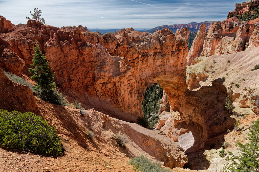
A Portrait Orientation of the Natural Bridge in Bryce Canyon National Park by Mark Stevens
Via Flickr:
A setting looking to the southeast while taking in views of Natural Bridge at the overlook for that in Bryce Canyon National Park.
#Aquarius Plateau#Azimuth 144#Blue Skies#Bryce Canyon#Bryce Canyon National Park#Central Utah Plateaus#Colorado Plateau#Day 4#Desert Landscape#Desert Mountain Landscape#Desert Plant Life#DxO PhotoLab 5 Edited#Eastern Edge of the Paunsaugunt Plateau#Eroded Formations#Evergreen#Evergreens#High Desert#Hoodoos#Horseshoe-shaped Amphitheater#Intermountain West#Landscape#Landscape - Scenery#Layers of Rock#Looking SE#Natural Bridge#Natural Bridge Area#Nature#Nikon D850#No People#Outside
1 note
·
View note
Video
Adventure Found for Exploration in Monahans Sandhills State Park by Mark Stevens
Via Flickr:
While taking in views looking to the southeast and across a sandy landscape with dune formations and wild grasses in Monahans Sandhills State Park.
#Azimuth 144#Blue Skies#Blue Skies with Clouds#Chihuahuan Desert#Day 5#Desert#Desert Landscape#Desert Plant Life#Dune Ridges#DxO PhotoLab 6 Edited#Great Plains#Landscape#Landscape - Scenery#Llano Estacado#Looking SE#Monahans Sandhills#Monahans Sandhills State Park#Nature#Nikon D850#No People#North America Plains#Outside#Partly Sunny#Permian Basin#Pump Jack Picnic Area#Sand#Sand Dunes#Scenics - Nature#SnapBridge#Southern Great Plains
0 notes
Video

flickr
A Meandering Path Through the Mountains Leads to the Soul of My Imagination by Mark Stevens
Via Flickr:
A setting looking to the southeast while taking in views across a mountain valley with evergreen trees present in this part of the San Juan National Forest. This was at a roadside pullout along US Route 550 (San Juan Skyway Scenic and Historic Byway) in southeastern Colorado. Off in the distance are the ridges and peaks of Twilight Peak of Pigeon Peak that part of the San Juan and Needle Mountains.
#Azimuth 144#Blue Skies#Blues Skies with Clouds#Canvas#Day 7#DxO PhotoLab 7 Edited#Evergreen Trees#Evergreens#Forest#Forest Landscape#Hillside of Trees#Landscape#Landscape - Scenery#Looking SE#Mountain Peak#Mountains#Mountains in Distance#Mountains off in Distance#Mountainside#Nature#Needle Mountains#New Mexico and Mesa Verde National Park#Nikon D850#Outside#Partly Sunny#Pigeon Peak#Portfolio#Project365#Ridge#Ridgeline
0 notes
Video

flickr
Taking a Time out in Bryce Canyon National Park by Mark Stevens
Via Flickr:
While at the overlook to Natural Bridge with a view looking to the southeast at the namesake formation in Bryce Canyon National Park. My thought on composing this image was to zoom in with the focal length and have much of the formation fill the image, while still including a little bit of foreground and blue skies above to provide a setting for this location.
#Aquarius Plateau#Azimuth 144#Blue Skies#Bryce Canyon#Bryce Canyon National Park#Central Utah Plateaus#Colorado Plateau#Day 4#Desert Landscape#Desert Mountain Landscape#Desert Plant Life#DxO PhotoLab 5 Edited#Eastern Edge of the Paunsaugunt Plateau#Eroded Formations#Evergreen#Evergreens#High Desert#Hoodoos#Horseshoe-shaped Amphitheater#Intermountain West#Landscape#Landscape - Scenery#Layers of Rock#Looking SE#Natural Bridge#Natural Bridge Area#Nature#Nikon D850#No People#Outside
1 note
·
View note
Video
Hello Pinnacles National Park! by Mark Stevens
Via Flickr:
While at the Chaparral Trailhead Parking after walking a few miles of trails in this part of Pinnacles National Park. The view is looking to the southeast to the High Peaks area in this part of the national park. What drew me into the setting was the layered approach in my mind that this area had. Nearby would be sage brushes that sloped downward from left to right. Then would come the volcanic and eroded rock formations on the more distant ridge. I decided to zoom in with a focal length and have this setting fill much of the lower and a little bit of the upper portion of the image. The blue skies and wisps of clouds would be that color contrast to complement the earth-tones in the lower portion of the image.
#Azimuth 144#Balconies Cave Loop#Blue Skies#Blues Skies with Clouds#Central California Coast Ranges#Central and Southern California Ranges#Day 2#DxO PhotoLab 6 Edited#Eroded Leftovers#Forest#Forest Landscape#Gabilan Range#Hawkins Peak#High Peaks#Hillside of Trees#Landscape#Landscape - Scenery#Looking SE#Mountain Peak#Mountains#Mountains in Distance#Mountains off in Distance#Mountainside#Nature#Neenach Volcano#Nikon D850#No People#Outside#Pacific Ranges#Partly Sunny
0 notes
Video
Natural Bridge, the Gift of Going to Bryce Canyon National Park by Mark Stevens
Via Flickr:
A setting looking to the southeast while taking in views of Natural Bridge at the overlook to that point in Bryce Canyon National Park. My thought on composing this image was to keep the bridge more or less centered, but pull back on the focal length to include some foreground and surrounding landscape to add to the setting with the image captured.
#Aquarius Plateau#Azimuth 144#Blue Skies#Bryce Canyon#Bryce Canyon National Park#Central Utah Plateaus#Colorado Plateau#Day 4#Desert Landscape#Desert Mountain Landscape#Desert Plant Life#DxO PhotoLab 5 Edited#Eastern Edge of the Paunsaugunt Plateau#Eroded Formations#Evergreen#Evergreens#High Desert#Hoodoos#Horseshoe-shaped Amphitheater#Intermountain West#Landscape#Landscape - Scenery#Layers of Rock#Looking SE#Natural Bridge#Natural Bridge Area#Nature#Nikon D850#No People#Outside
1 note
·
View note
Video
flickr
Sometimes We Are Blessed to See Things at Different Times in Our Lives (Bryce Canyon National Park) by Mark Stevens
Via Flickr:
Sometimes We Are Blessed to See Things at Different Times in Our Lives While others are only for a that season The first time I was here, snow blanketed this natural bridge And now the sun shines that spring time look and brings out a red glow A new perspective from time and now of colors So like the words of a song, but so slightly changed I’ve seen fire and I’ve seen snow Another work of short poetry or prose to complement the image captured one mooning in Bryce Canyon National Park from an overlook to Natural Bridge. The view is looking to the southeast. My thoughts on composing this image was pull back on the focal length and use a wide angle with the lens that I had, including Area around the base of the bridge as well as some surrounding landscape. I felt that would give not only a sense of scale and perspective, but also add to the setting of the image captured. I was able to include some blue skies above which I felt acted as a color contrast to compliment the earth-tones in the rest of the image. I did some initial post-processing work making adjustments to contrast, brightness and saturation in DxO PhotoLab 5. I then exported a TIFF image to DxO FilmPack 6 where I found a preset that really seemed to bring out more of the reds present at this location. The first image I captured after a snow storm is located here on Flickr here (www.flickr.com/photos/markcstevens/14947610258/in/album-7...).
#Aquarius Plateau#Azimuth 144#Blue Skies#Blue Skies with Clouds#Bryce Canyon#Bryce Canyon National Park#Canvas#Canyonlands#Color Efex Pro#Colorado Plateau#Day 4#Desert Landscape#Desert Mountain Landscape#Desert Plant Life#DxO PhotoLab 5 Edited#Eastern Edge of the Paunsaugunt Plateau#Eccezionale#Eroded Formations#Evergreen#Evergreens#FilmPack 6#Free Verse Poetry#High Desert#Hoodoos#Horseshoe-shaped Amphitheater#Intermountain West#Landscape#Landscape - Scenery#Layers of Rock#Looking SE
0 notes
Video
Adventure Found for Exploration in Monahans Sandhills State Park by Mark Stevens
Via Flickr:
While taking in views looking to the southeast and across a sandy landscape with dune formations and wild grasses in Monahans Sandhills State Park.
#Azimuth 144#Blue Skies#Blue Skies with Clouds#Chihuahuan Desert#Day 5#Desert#Desert Landscape#Desert Plant Life#Dune Ridges#DxO PhotoLab 6 Edited#Great Plains#Landscape#Landscape - Scenery#Llano Estacado#Looking SE#Monahans Sandhills#Monahans Sandhills State Park#Nature#Nikon D850#No People#North America Plains#Outside#Partly Sunny#Permian Basin#Pump Jack Picnic Area#Sand#Sand Dunes#Scenics - Nature#SnapBridge#Southern Great Plains
0 notes
Video
flickr
Taking a Time out in Bryce Canyon National Park by Mark Stevens
Via Flickr:
While at the overlook to Natural Bridge with a view looking to the southeast at the namesake formation in Bryce Canyon National Park. My thought on composing this image was to zoom in with the focal length and have much of the formation fill the image, while still including a little bit of foreground and blue skies above to provide a setting for this location.
#Aquarius Plateau#Azimuth 144#Blue Skies#Bryce Canyon#Bryce Canyon National Park#Central Utah Plateaus#Colorado Plateau#Day 4#Desert Landscape#Desert Mountain Landscape#Desert Plant Life#DxO PhotoLab 5 Edited#Eastern Edge of the Paunsaugunt Plateau#Eroded Formations#Evergreen#Evergreens#High Desert#Hoodoos#Horseshoe-shaped Amphitheater#Intermountain West#Landscape#Landscape - Scenery#Layers of Rock#Looking SE#Natural Bridge#Natural Bridge Area#Nature#Nikon D850#No People#Outside
0 notes
Last Seen Blogs

nyiror
Untitled


kacesacramento-blog
Kristina Camille ♥

yarnstoresaustralia-blog
Yarns Of Collie

mozilla-firefox
manifest v3 more like manifest :3