#BikeMap
Explore tagged Tumblr posts
Visit Tumblr Blog
Explore Tumblr blogs with no restrictions, modern design and the best experience.
Last Seen Tumblr Blogs


Fun Fact
Tumblr has a 66 index score for customer satisfaction in the US.
Text
Greater Northshore Bike Connector Map 1.6.1 – 3 May 2025 – is now available on github, as is MEGAMAP 1.6.1.
This release wasn’t supposed to happen yet – arguably at all, the next was supposed to be 1.7 – but I mislabelled a couple of blocks of split sharrow/bike lane in Snohomish County as full both-sides bike lanes and that’s not okay. I had to get that fixed, and I have, so: new maps drop. Corrections are in all latest maps, of course.
Additions and changes since 1.6:
Correction of errors on 84th West in Snohomish County, where sharrows had been incorrectly shown as full bike lanes across a couple of blocks where only one side has full bike lanes
Added bike lane markers for Forbes Creek Drive in Kirkland
Further cleanup of the trail situation in and around Crestwoods Park, Kirkland
Added Old Market Street Trail in Juanita
Added continuation notes showing how far infrastructure continues on the MEGAMAP’s northern border

All permalinks continue to work.
If you enjoy these maps and feel like throwing some change at the tip jar, here’s my patreon. Patreon supports get things like pre-sliced printables of the Greater Northshore, and also the completely-uncompressed MEGAMAP, not that the .jpg has much compression in it because it doesn’t. If you have an iPhone, please use the website interface and not the app, because Apple takes 30% if you use the app. I’ll keep doing this regardless, but you know. Thank you! ^_^
#map#maps#BikeMap#Bike Map#bicycling#seattle#king county#snohomish county#cascadia#shoreline#lake forest park#kenmore#juanita#bothell#woodinville#redmond#maltby#brier#mountlake terrace#lynnwood#edmonds#biking#cycling
2 notes
·
View notes
Text
0 notes
Text
tomorrow most of the public transport in my city is on strike so I'm biking to work
had to fix my bike today and looked at routes to work, since I have only ever gone there by train, on gmaps and some bike route planners and they are all bad
the bikemap route keeps taking detours to be on quieter streets but most of those are either cobblestone or uphill so I will ignore those for me and my bikes sanities and simply take their route as a general suggestion
#race bikes and cobbled streets do not get along#google maps said to either take some of the car heaviest roads in the city centre or two extra kilometres#and you can do neither miraculously enough
1 note
·
View note
Text
0 notes
Text
AI-Enhanced Travel: Seamless Journeys Ahead
Artificial Intelligence (AI) is revolutionizing the way we plan our travels. As the summer travel season unfolds, the demand for software that offers more than just basic booking assistance is evident. Today, travelers seek solutions that not only streamline the process of flight and hotel reservations but also provide tailored recommendations, eco-conscious options, and personalized experiences to ensure a seamless and unforgettable vacation.
AI Integration in Travel Planning
The integration of AI into the travel sector marks a significant shift in how journeys are planned and experienced. Cutting-edge platforms like Google's Gemini have emerged as leaders in this space, leveraging AI algorithms to provide customized recommendations that surpass the offerings of traditional booking sites. These AI assistants go beyond simple booking assistance; they curate comprehensive itineraries, taking into account various factors such as budget constraints, travel preferences, and cultural interests.
For example, Layla (formerly known as Roam Around) has partnered with platforms like Skyscanner to enhance travel planning without upfront fees, offering enriched search results spanning flight bookings, accommodations, and guided excursions. Similarly, Roadtrippers caters to road enthusiasts, providing tools for live updates, route customization, and air quality readings, thereby empowering travelers to tailor their journeys to their liking.
Even established platforms like TripAdvisor and Expedia are not immune to the AI revolution. These platforms have begun incorporating AI-driven features to automate the creation of bespoke travel plans, ensuring that they remain favorites among a diverse range of travel enthusiasts.
Challenges and Limitations of AI in Travel Planning
However, despite the many benefits AI brings to travel planning, it is not without its challenges and limitations. One common issue is the lack of personalization in AI recommendations, as algorithms may favor well-trodden paths or data-rich choices, potentially overlooking unique, lesser-known experiences that could captivate different travelers. Additionally, there is the challenge of inherent biases in AI recommendations, which may prioritize options with sponsorship ties or commercial partnerships with the AI provider, potentially steering travelers towards choices that benefit the AI's affiliates rather than aligning with their genuine interests.
To navigate these challenges, it is essential for travelers to use AI as a guide rather than a definitive source. While AI can offer unparalleled convenience and personalization, it is crucial to supplement its recommendations with additional research and verification to ensure that the chosen options align with one's individual preferences and values.
Eco-Conscious Travel: Promoting Sustainable Tourism Practices
In recent years, there has been a growing emphasis on eco-conscious travel, with travelers increasingly seeking ways to minimize their environmental impact while exploring the world. This trend has led to the development of various tools and platforms aimed at promoting sustainable tourism practices.
Tech giants like Google Maps and Apple Maps have been at the forefront of promoting green travel options. Google Maps now highlights train links, flights with lower emissions, and spots to charge electric cars, making it easier for travelers to make environmentally friendly choices. Apple Maps, on the other hand, offers extensive options for public transport, walking, biking, and electric vehicle paths, further encouraging travelers to reduce their carbon footprint.
In addition to these mainstream platforms, there are also niche apps that cater to eco-conscious travelers. Citymapper and Bikemap, for example, provide directions for public transport, cycling routes, and walking paths, making it easier for travelers to explore cities in a sustainable manner. For those looking to eat in a way that is kinder to the planet, apps like HappyCow list vegetarian and vegan-friendly restaurants, while the Tap Hydration and Water Stations app helps travelers find places to refill their water bottles, reducing the need for single-use plastics.
Travel Organization Tools
In addition to eco-conscious travel, another area where AI is making a significant impact is in travel organization. With the proliferation of digital tools and platforms, travelers now have access to a wide range of apps and services that can help them streamline the process of planning and organizing their trips.
Apps like TripIt, TripCase, and Wanderlog are leading the way in this regard, offering features that allow travelers to consolidate all their travel information in one place, from flight details and hotel bookings to rental car reservations and activity bookings. These apps use AI algorithms to scan booking confirmation emails and extract relevant information, making it easier for travelers to stay organized and keep track of their plans.
For those looking for more advanced features, premium versions of these apps are available, offering real-time updates, calendar integration, and personalized recommendations based on travel preferences and past behavior. These tools not only make the process of travel planning more efficient but also ensure that travelers have all the information they need at their fingertips, allowing them to relax and enjoy their trips without having to worry about the details.
In conclusion, AI is revolutionizing the way we plan and experience our travels. From personalized recommendations and eco-conscious options to streamlined organization and enhanced efficiency, AI is reshaping every aspect of the travel industry. As technology continues to advance, these tools will only become more sophisticated and intuitive, offering travelers even greater convenience and flexibility. However, it is essential to use AI as a supplement to traditional research and planning, rather than a replacement, to ensure that our travel experiences are truly tailored to our individual preferences and values.
FAQ
1. How does AI integration in travel planning enhance my vacation experience?
AI-driven platforms like Google's Gemini provide personalized recommendations, considering factors like budget, travel preferences, and cultural interests, resulting in comprehensive and tailored itineraries. These platforms streamline the planning process, making vacation organization more efficient and hassle-free.
2. Can AI-driven platforms effectively address the challenges and limitations of travel planning?
While AI brings numerous benefits to travel planning, it is not without its challenges. Issues such as lack of personalization and inherent biases in recommendations are common. However, AI platforms continuously improve, and travelers can navigate these challenges by supplementing AI recommendations with additional research and verification.
3. How are tech giants promoting eco-conscious travel options?
Tech giants like Google Maps and Apple Maps are at the forefront of promoting eco-conscious travel. They highlight environmentally friendly transportation options such as train links, flights with lower emissions, and electric car charging stations. Additionally, niche apps like Citymapper and Bikemap provide directions for sustainable transportation methods like public transit, cycling, and walking.
4. What role do travel organization tools play in the AI-driven travel planning landscape?
Travel organization tools like TripIt, TripCase, and Wanderlog consolidate all travel information, including flight details, hotel bookings, and activity reservations, in one place. These tools offer real-time updates, calendar integration, and personalized recommendations, ensuring travelers have access to all necessary information and making the planning process more streamlined and efficient.
5. How can travelers ensure that their AI-driven travel plans align with their individual preferences and values?
While AI provides personalized recommendations, it's essential for travelers to verify recommendations and supplement them with additional research. Travelers should also consider their individual preferences and values when making decisions, ensuring that their travel experiences align with their unique desires and priorities.
Author details:
Creator: Vineetha Company: Addonez- IT consulting firm Category: Tours and travel
0 notes
Text
Greater Northshore Bike Connector Map 1.5 – 21 February 2025 – is now available on github, as is MEGAMAP 1.5.
With this version, the Greater Northshore Map has adopted our MEGAMAP’s former Empty Quarter, previously a basically empty paste-in of King County Regional Trails. It is now a peer map section with Greater Northshore proper, City of Seattle, and 2 Line Eastside Bike Connector.
There may not be a lot down there, but what’s down there is now properly mapped and included.

Additions and changes since 1.4.6:
ALL OF NEWCASTLE, as far as I know. Thanks to Kerry Sullivan (City of Newcastle) for help on unpublished but completed new May Creek Park Drive bike lanes
NORTHERNMOST RENTON, including substantial upgrades to Lake Washington Loop route markings, particularly street names for the chunk where it’s just bike lanes
New-to-me bike lanes around 100th Ave W. in Edmonds, now mapped
Upgrade to 15th Avenue S bike lanes in the Seattle map – they now have physical separation. There’s a warning flag because they’re still intermittently being worked on a little? But as far as I can tell they are generally open.
All permalinks continue to work.
If you enjoy these maps and feel like throwing some change at the tip jar, here’s my patreon. Patreon supports get things like pre-sliced printables of the Greater Northshore, and also the completely-uncompressed MEGAMAP, not that the .jpg has much compression in it because it doesn’t. If you have an iPhone, please use the website interface and not the app, because Apple takes 30% if you use the app. I’ll keep doing this regardless, but you know. Thank you! ^_^
#map#maps#bike map#bikemap#biking#bicycling#seattle#shoreline#lake forest park#kenmore#bothell#woodinville#juanita#kirkland#redmond#king county#newcastle
5 notes
·
View notes
Text
Le migliori app per piste ciclabili in Italia

Nell’era digitale, l’uso delle app per piste ciclabili è diventato un elemento fondamentale per gli appassionati di ciclismo. In Italia, un paese che vanta una ricca varietà di paesaggi e percorsi ciclabili, queste applicazioni sono strumenti preziosi per scoprire e godere delle bellezze naturali e culturali offerte dal territorio. Che si tratti di un giro rilassante in città o di un’avventura su lunghe distanze, le migliori app possono trasformare ogni uscita in bici in un’esperienza unica e personalizzata.
App per piste ciclabili in Italia: Esplora l'Italia in bici con le migliori app per trovare percorsi, navigare e registrare le tue uscite.
Il ciclismo, oltre a essere un ottimo esercizio fisico, rappresenta un modo ecologico e sostenibile di esplorare il paese. Le app per piste ciclabili non solo forniscono accesso a informazioni dettagliate e mappe interattive, ma promuovono anche uno stile di vita attento all’ambiente. Vediamo quindi quali sono le migliori app disponibili per i ciclisti in Italia.
Perché Utilizzare le App per Piste Ciclabili?
L'Italia, con la sua varietà di paesaggi e il suo ricco patrimonio culturale, offre numerose opportunità per gli appassionati di ciclismo. Che tu sia un ciclista urbano o un avventuriero alla ricerca di nuovi percorsi, esistono diverse app che possono aiutarti a trovare le migliori piste ciclabili nel Bel Paese. Facilità di Accesso alle Informazioni Le app per piste ciclabili offrono una vasta gamma di dati, da mappe dettagliate a informazioni su distanza e difficoltà dei percorsi. Questo permette ai ciclisti di avere sempre a portata di mano informazioni aggiornate, essenziali per pianificare al meglio le proprie uscite. Personalizzazione del Percorso Con le migliori app, è possibile personalizzare il proprio itinerario in base alle proprie preferenze e capacità fisiche. Questo significa poter scegliere percorsi adatti sia per una breve pedalata che per un tour di più giorni, con la possibilità di salvare i propri percorsi preferiti e condividerli con altri utenti.
Le Migliori App per Piste Ciclabili in Italia
La scelta dell'app giusta per te dipenderà dalle tue esigenze e dal tuo livello di esperienza. Se sei un principiante, potresti preferire un'app con una varietà di funzioni di base, se sei un ciclista più esperto, potresti preferire un'app con funzioni avanzate, ma senza perdere tempo ecco le migliori: Bikemap (Android/iOS)

Bikemap è un'applicazione per la mappatura e la condivisione di percorsi ciclabili in tutto il mondo. È progettata per i ciclisti di ogni livello, dai principianti agli esperti, e offre una vasta gamma di funzionalità per aiutare gli utenti a pianificare le loro rotte in bicicletta. Mappatura dei percorsi Bikemap offre una vasta selezione di percorsi ciclabili mappati dagli utenti stessi. Puoi esplorare mappe interattive e cercare percorsi in base alla posizione geografica o alle preferenze personali, come la lunghezza del percorso, il livello di difficoltà o il tipo di terreno. Pianificazione del percorso Puoi utilizzare l'app per pianificare il tuo percorso ciclabile personalizzato. Basta selezionare il punto di partenza e di arrivo desiderati, e l'app ti fornirà la migliore rotta possibile, tenendo conto di piste ciclabili, strade secondarie a basso traffico e altre informazioni utili. Navigazione GPS Una volta che hai pianificato il tuo percorso, puoi attivare la funzione di navigazione GPS e utilizzare l'app come guida durante il tuo viaggio in bicicletta. L'app ti fornirà indicazioni passo-passo, avvisi vocali e notifiche sullo schermo per assicurarti di rimanere sulla strada giusta. Registrazione delle attività Puoi utilizzare Bikemap per registrare le tue attività ciclistiche, tenendo traccia della distanza percorsa, della velocità media, del tempo di percorrenza e di altre statistiche. Questo ti aiuta a monitorare i tuoi progressi nel tempo e a condividere le tue esperienze con la comunità di Bikemap. Condivisione e scoperta di percorsi Bikemap offre anche una vivace comunità di ciclisti che condividono i loro percorsi preferiti. Puoi caricare i tuoi percorsi e condividerli con gli altri, o esplorare le mappe per scoprire nuovi itinerari raccomandati dagli utenti. Informazioni sulle caratteristiche del percorso L'app fornisce anche informazioni dettagliate sui percorsi, come la presenza di salite, discese, terreni accidentati o punti di interesse lungo il percorso. Questo ti aiuta a scegliere percorsi adatti alle tue preferenze e capacità. Bikemap è disponibile come app per dispositivi mobili su iOS e smartphone con sistema Android, e offre una versione gratuita con funzionalità di base, così come un abbonamento premium che sblocca funzionalità aggiuntive come la navigazione vocale offline e la sincronizzazione con dispositivi GPS esterni. Naviki (Android/iOS)

Naviki è un'applicazione per la navigazione e la pianificazione di percorsi ottimizzati per biciclette, pedoni e mezzi di trasporto pubblico. È progettata per aiutare gli utenti a trovare il percorso migliore e più sicuro per raggiungere la loro destinazione, tenendo conto delle preferenze individuali e delle condizioni stradali. Pianificazione del percorso Naviki ti consente di pianificare facilmente il tuo percorso da un punto A a un punto B. Puoi inserire la tua destinazione desiderata e l'app calcolerà il percorso ottimale per te. Puoi specificare le tue preferenze, come la distanza massima, il tipo di strade o sentieri preferiti e l'intensità del traffico. Scelta del mezzo di trasporto Naviki supporta diversi mezzi di trasporto, inclusi il ciclismo, il camminare e l'uso del trasporto pubblico. Puoi selezionare il mezzo di trasporto desiderato e l'app calcolerà il percorso in base a ciò. Ad esempio, se scegli di andare in bicicletta, Naviki ti guiderà su percorsi ciclabili e strade adatte alle biciclette. Navigazione GPS Una volta pianificato il percorso, puoi attivare la funzione di navigazione GPS per essere guidato durante il tuo viaggio. Naviki ti fornirà indicazioni passo-passo sullo schermo del tuo dispositivo, indicandoti le svolte da prendere e le distanze da percorrere. In questo modo puoi rimanere orientato durante il tuo viaggio. Informazioni sul percorso Naviki fornisce informazioni dettagliate sul percorso, come la distanza totale, il tempo di percorrenza stimato, la presenza di pendenze o salite e altre caratteristiche del terreno. Queste informazioni ti aiutano a pianificare meglio il tuo viaggio e a comprendere cosa aspettarti lungo il percorso. Funzioni aggiuntive Naviki offre anche alcune funzioni aggiuntive utili. Ad esempio, puoi salvare i tuoi percorsi preferiti e accedere ad essi in qualsiasi momento. Puoi anche registrare le tue attività ciclistiche e monitorare le tue statistiche, come la distanza percorsa, la velocità media e le calorie bruciate. Integrazione con dispositivi e servizi esterni: Naviki può essere integrato con dispositivi GPS esterni o app di fitness come Strava, consentendo il tracciamento e la sincronizzazione delle tue attività. Naviki è disponibile come app per dispositivi mobili su iOS e smartphone Android ed è utilizzabile gratuitamente con funzionalità di base. Tuttavia, offre anche un abbonamento premium che sblocca funzioni aggiuntive come la navigazione vocale e l'accesso offline ai percorsi. Komoot (Android/iOS)

Komoot è un'applicazione per la pianificazione di avventure all'aperto, specialmente per il ciclismo e l'escursionismo. L'app ti consente di scoprire nuovi percorsi, pianificare le tue avventure e navigare in modo affidabile durante i tuoi viaggi. Pianificazione di percorsi personalizzati Komoot ti consente di pianificare i tuoi percorsi personalizzati in base alle tue preferenze e alle tue esigenze. Puoi definire il punto di partenza e di arrivo, specificare il tipo di attività all'aperto (come ciclismo, escursionismo o mountain bike) e impostare le tue preferenze di terreno e difficoltà. L'app calcola quindi il percorso ottimale per te, tenendo conto di sentieri, strade asfaltate, pendenze e altre caratteristiche. Navigazione Una volta pianificato il percorso, Komoot offre una navigazione affidabile per guidarti durante il tuo viaggio. Puoi attivare la navigazione GPS e l'app ti fornirà indicazioni dettagliate, turn-by-turn, sullo schermo del tuo dispositivo. La navigazione viene fornita anche con informazioni sulle distanze, punti di interesse lungo il percorso e tempi di percorrenza stimati. Mappatura e scoperta di nuovi percorsi Komoot dispone di una vasta mappa interattiva in cui puoi esplorare nuovi percorsi e regioni. Puoi cercare percorsi consigliati dagli utenti, visualizzare foto e recensioni di luoghi interessanti e scoprire nuove avventure all'aperto. Inoltre, Komoot offre una funzione chiamata "Pianificatore di Tour" che ti consente di creare itinerari circolari, in modo che tu possa tornare al punto di partenza senza ripetere lo stesso percorso. Informazioni dettagliate del percorso Komoot fornisce informazioni approfondite sul percorso, come la distanza totale, il dislivello, la difficoltà, l'asfalto o il terreno naturale e le attrazioni lungo il percorso. Questo ti aiuta a valutare il livello di sfida e a pianificare adeguatamente la tua avventura. Funzionalità offline Komoot offre la possibilità di scaricare mappe e percorsi per l'uso offline. Puoi scaricare le mappe delle regioni in cui intendi andare e utilizzarle senza una connessione Internet attiva. Ciò è particolarmente utile in zone remote o in caso di connessione limitata. Integrazione con dispositivi e servizi esterni Komoot può essere integrato con dispositivi GPS esterni, come orologi da corsa o ciclocomputer, per registrare le tue attività e sincronizzarle con l'app. Inoltre, Komoot può essere collegato a servizi di terze parti, come Strava, per condividere le tue avventure e confrontare le tue prestazioni con altri atleti. Komoot è disponibile come app per dispositivi mobili su iOS e cellulari Android ed è utilizzabile gratuitamente con funzionalità di base. Tuttavia, offre anche un abbonamento premium che sblocca funzioni aggiuntive, come il pacchetto "Mondo" che offre accesso a tutte le regioni mappate da Komoot. Ride with GPS (Android/iOS)

Ride with GPS è un'applicazione per ciclisti che offre funzionalità di tracciamento, pianificazione di percorsi e navigazione. È progettata per consentire ai ciclisti di registrare le proprie attività, scoprire nuovi percorsi e navigare in modo affidabile durante i loro viaggi. Tracciamento delle attività Ride with GPS ti consente di registrare le tue attività ciclistiche utilizzando il GPS del tuo dispositivo. Puoi avviare e interrompere la registrazione durante il tuo viaggio e l'app registrerà informazioni come la distanza percorsa, la velocità, l'altitudine e il tempo impiegato. Queste informazioni possono essere salvate per il tuo riferimento personale o condivise con la comunità di Ride with GPS. Pianificazione di percorsi Ride with GPS offre strumenti per pianificare i tuoi percorsi in anticipo. Puoi creare un percorso personalizzato tracciando manualmente i punti di interesse sulla mappa o importando percorsi da file GPX o TCX. L'app calcola automaticamente la distanza, l'altitudine e altre statistiche del percorso. Puoi anche utilizzare le funzionalità di ricerca per scoprire percorsi popolari nella tua zona o in altre regioni. Navigazione Una volta pianificato il percorso, Ride with GPS offre la navigazione guidata per aiutarti a seguire il percorso durante la tua pedalata. L'app ti fornirà indicazioni chiare e turn-by-turn sullo schermo del tuo dispositivo, in modo da sapere sempre quali svolte prendere e dove andare. La navigazione funziona anche offline, quindi non hai bisogno di una connessione Internet attiva durante il tuo viaggio. Caratteristiche avanzate Ride with GPS include alcune funzionalità avanzate per migliorare la tua esperienza di ciclismo. Ad esempio, puoi impostare avvisi vocali o sonori per tenerti informato sulle tue statistiche di guida durante il percorso. Puoi anche visualizzare grafici dettagliati delle tue prestazioni, come il profilo altimetrico del percorso o la distribuzione della velocità lungo il percorso. Condivisione e comunità Ride with GPS offre una piattaforma di condivisione e una comunità di ciclisti. Puoi condividere le tue attività con gli amici o la community di Ride with GPS, visualizzare e commentare le attività degli altri e partecipare a sfide o gruppi tematici. Questo ti consente di connetterti con altri ciclisti, ottenere ispirazione e condividere le tue avventure. Ride with GPS è disponibile come app per dispositivi mobili su iOS e smartphone Android. È possibile utilizzare l'app gratuitamente con funzionalità di base, ma offre anche un abbonamento premium che sblocca funzioni aggiuntive come la navigazione vocale, l'accesso offline ai mappe e altre caratteristiche avanzate. ViewRanger (Android/iOS)

ViewRanger è un'applicazione per gli amanti delle attività all'aperto, come l'escursionismo, il trekking, il ciclismo e altre attività outdoor. L'app offre una vasta gamma di funzionalità per aiutarti a pianificare le tue avventure, navigare sul campo e scoprire nuovi percorsi. Pianificazione delle avventure ViewRanger ti consente di pianificare le tue avventure all'aperto in anticipo. Puoi cercare mappe dettagliate delle regioni che desideri esplorare e tracciare il tuo percorso utilizzando gli strumenti di disegno sulla mappa. L'app offre anche una vasta libreria di percorsi predefiniti, forniti dalla comunità di ViewRanger o da partner affidabili, che puoi utilizzare come punto di partenza per le tue avventure. Navigazione sul campo Una volta che hai pianificato il tuo percorso, ViewRanger offre funzionalità di navigazione per aiutarti a seguire il percorso durante il tuo viaggio. Puoi attivare la navigazione GPS e l'app ti fornirà indicazioni chiare e dettagliate sullo schermo del tuo dispositivo, inclusi avvisi vocali e visivi per le svolte e i punti di interesse lungo il percorso. La navigazione funziona anche offline, quindi non hai bisogno di una connessione Internet attiva durante l'escursione. Mappe e informazioni dettagliate ViewRanger offre una vasta selezione di mappe topografiche, stradali e satellitari da utilizzare durante le tue avventure. Puoi scegliere tra una varietà di fonti di mappe, inclusi i dati ufficiali di agenzie cartografiche, per ottenere informazioni accurate sul terreno, le altitudini e altre caratteristiche. Inoltre, l'app fornisce informazioni dettagliate sui punti di interesse lungo il percorso, come rifugi, punti panoramici, fonti d'acqua e molto altro. Registrazione delle attività ViewRanger ti consente di registrare le tue attività all'aperto, come escursioni o giri in bicicletta. Durante la registrazione, l'app traccia automaticamente le tue statistiche come la distanza percorsa, l'altitudine, il tempo impiegato e la velocità. Puoi salvare queste attività per rivederle in seguito o condividerle con la comunità di ViewRanger. Esplorazione e scoperta ViewRanger offre una funzione di scoperta che ti consente di esplorare nuovi percorsi e avventure. Puoi cercare percorsi consigliati dalla community di ViewRanger o da partner locali, visualizzare foto, recensioni e informazioni dettagliate sui percorsi, e ottenere ispirazione per le tue prossime avventure. Condivisione e connessione ViewRanger ti consente di condividere le tue avventure con gli amici e la comunità. Puoi condividere le tue attività, foto e commenti sui social media o tramite la piattaforma di ViewRanger stessa. Puoi anche connettere l'app a dispositivi o sensori esterni, come orologi da polso o sensori di frequenza cardiaca, per registrare dati aggiuntivi durante le tue attività. ViewRanger è disponibile come app per dispositivi mobili su iOS e telefonini Android, ed è utilizzabile gratuitamente con funzionalità di base. Tuttavia, offre anche una versione premium che sblocca funzioni aggiuntive, come l'accesso a mappe premium, la navigazione vocale e altre caratteristiche avanzate.
Conclusione
Le app per piste ciclabili sono diventate alleati indispensabili per i ciclisti. Read the full article
0 notes
Text
0 notes
Text
0 notes
Text
Since the Montlake Cap over SR-520 didn't its trails open by end of October as per the previous deadline, I've gone ahead and dropped a new Greater Northshore Bike Connector Map and a new MEGAMAP for southwest Snohomish County down through Renton.
This is a minor release with a couple of corrections and removal of a construction warning flag in Bothell, thanks to the repaving project on Sammamish River Trail being complete.
Previous permalinks continue to be valid.
#Bike Map#BikeMap#maps#biking#cycling#seattle#shoreline#lake forest park#northshore#kenmore#juanita#kirkland#bothell#woodinville#king county#snohomish county#washington state
1 note
·
View note
Photo

¿Conoces @bikemap? ¡Es una aplicación para realizar salidas en bicicleta! 📱🚲 @bikemap ezagutzen al duzu? Bizikletan irteerak egiteko aplikazio bat da! 📲🚲 #bikemap #app #aplicacion #bicicleta #bici #gps #salidas #tecnologia #digital #movil #deporte #salud #saludable #ejercicio #bike #cycling #sport #vidasaludable #medioambiente #ecología #apps #aplicaciones #ciclista #ciclistas #ciclismo #ruta #rutas #ordenadores #ordenador #novedad (en San Sebastián, Pais Vasco, Spain) https://www.instagram.com/jonlasagaldos/p/CY3U3NZt_L4/?utm_medium=tumblr
#bikemap#app#aplicacion#bicicleta#bici#gps#salidas#tecnologia#digital#movil#deporte#salud#saludable#ejercicio#bike#cycling#sport#vidasaludable#medioambiente#ecología#apps#aplicaciones#ciclista#ciclistas#ciclismo#ruta#rutas#ordenadores#ordenador#novedad
0 notes
Text
0 notes
Text
Episode 3: Departure Day minus 25 weeks
Serious Training
The Stable: Bike No 2: 2012 Carbon Cannondale Synapse.
This is the first carbon bike I’ve owned; it has the same Shimano Ultegra kit but is a very different bike to ride from the Kinesis. With its shorter wheelbase it is more responsive & twitchier, designed for endurance it is still great to ride on good quality roads & I have used it mostly in France including some of the great Tour de France climbs including the Col de Port, Port de Lers & the Mur de Peguere. I’ll be using it for training once the weather improves & for longer rides.
youtube
This week I have cycled a couple of times, on both occasions I did what I call the Uplowman loop, about 14 miles, Holcombe Rogus - Sampford Peverell - Uplowman - Huntsham - Staple Cross - Hockworthy & back to Holcombe. In nice weather a great ride, steady uphill to Huntsham makes you work, level to Staple Cross & a steep downhill back to Holcombe so a good work out.
The 1st time the weather was wet & rubbish, the second dry & sunny, the second run was 5 minutes quicker so either I suddenly got extra fit or the sunshine helped. On both occasions the Staple Cross Inn wasn’t open otherwise my times may have been significantly different!
Here's a link to the route
Cheers Ian
Fundraising
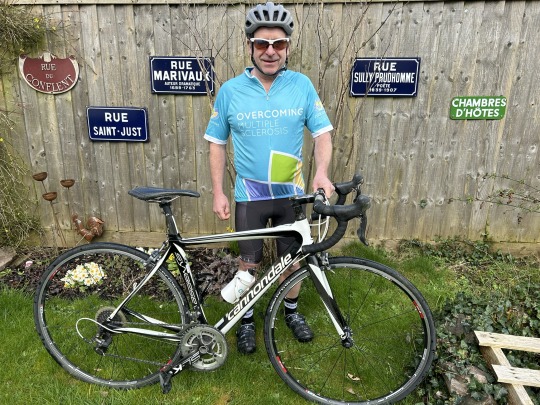
Wow, what a week this has been. For me its all been about fundraising. We have set ourselves a target of £2,000 for Overcoming MS.
Our friends in our village have been amazing and have taken the lead in organising Curry In A Hurry. This was a fundraising event we put on in our village a couple of years ago when trying to raise money to buy our pub.
Our village has a very small population and our pub and shop have closed. So, eating out means driving of getting a taxi (a very expensive option in the country) and getting a takeaway usually means that the food is only warm by the time it gets home.
Enter….Curry In A Hurry.

Some of our fabulous Curry Crew
For £10 you could choose from three curries with rice and get a poppadom, bhaji, chutney and raita thrown in. At such great value, we included the option to give an additional donation to Overcoming MS. This fabulous fundraiser only happened thanks to the amazing help of the Curry Crew volunteers:
Jane L & Miriam on planning, menu creation, food shopping and curry prep
Gordon on logistics and driving
Sally, Dorothy and Carol on curry cooking and order assembly, ready for deliveries
Rupert, John, Marcus and Andrew: Curry Crew drivers
Ian and myself on marketing and deliveries.
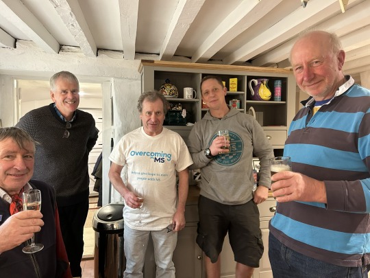
Some of the delivery crew. Curries despatched and enjoying a well earned drink
We can not say thank you enough, because with their help we raised
£651.00
which included curry orders and donations.

Many volunteers stayed on to enjoy some curry together. A very tiring but rewarding few days for Ian, myself and the volunteers.
Thank you for reading, Jane & Ian
If you would like to donate to help us on our way, please visit our Just Giving page.
0 notes
Photo

Excellent design, from the simple efficiency of the underground logo to the rich diversity and inclusivity of the bicyclists in the Santander bike map of London #design #simple #efficiency #inclusivity #diversity #bicyclists #santander #map #bikemap #mapoflondon #piccadilly #piccadillycircus #underground #station https://www.instagram.com/befriendedstranger/p/BxbUthIAaZW/?utm_source=ig_tumblr_share&igshid=1uequ49ehkq8l
#design#simple#efficiency#inclusivity#diversity#bicyclists#santander#map#bikemap#mapoflondon#piccadilly#piccadillycircus#underground#station
0 notes
Photo

#kevinminion #NAC #bubble #Fun #graffiti #throwie #graffiti #bx #bikemap #nyc #ny #bikemap #graffitiart #streetart #artmap #aerosol #urbanart #sprayart #143 https://www.instagram.com/p/BvpkLVZBpKw/?utm_source=ig_tumblr_share&igshid=t34yplzl63ju
#kevinminion#nac#bubble#fun#graffiti#throwie#bx#bikemap#nyc#ny#graffitiart#streetart#artmap#aerosol#urbanart#sprayart#143
0 notes