#Global Mapper
Explore tagged Tumblr posts
Visit Tumblr Blog
Explore Tumblr blogs with no restrictions, modern design and the best experience.
Last Seen Tumblr Blogs


Fun Fact
25% of US internet users with an annual income of $80-100K use Tumblr.
Text
Global Mapper Download 24.0 Crackeado PT-BR
1 note
·
View note
Text
Things the Biden-Harris Administration Did This Week #28
July 19-26 2024
The EPA announced the award of $4.3 billion in Climate Pollution Reduction Grants. The grants support community-driven solutions to fight climate change, and accelerate America’s clean energy transition. The grants will go to 25 projects across 30 states, and one tribal community. When combined the projects will reduce greenhouse gas pollution by as much as 971 million metric tons of CO2, roughly the output of 5 million American homes over 25 years. Major projects include $396 million for Pennsylvania’s Department of Environmental Protection as it tries to curb greenhouse gas emissions from industrial production, and $500 million for transportation and freight decarbonization at the ports of Los Angeles and Long Beach.
The Biden-Harris Administration announced a plan to phase out the federal government's use of single use plastics. The plan calls for the federal government to stop using single use plastics in food service operations, events, and packaging by 2027, and from all federal operations by 2035. The US government is the single largest employer in the country and the world’s largest purchaser of goods and services. Its move away from plastics will redefine the global market.
The White House hosted a summit on super pollutants with the goals of better measuring them and dramatically reducing them. Roughly half of today's climate change is caused by so called super pollutants, methane, hydrofluorocarbons (HFCs), and nitrous oxide (N2O). Public-private partnerships between NOAA and United Airlines, The State Department and NASA, and the non-profit Carbon Mapper Coalition will all help collect important data on these pollutants. While private firms announced with the White House plans that by early next year will reduce overall U.S. industrial emissions of nitrous oxide by over 50% from 2020 numbers. The summit also highlighted the EPA's new rule to reduce methane from oil and gas by 80%.
The EPA announced $325 million in grants for climate justice. The Community Change Grants Program, powered by President Biden's Inflation Reduction Act will ultimately bring $2 billion dollars to disadvantaged communities and help them combat climate change. Some of the projects funded in this first round of grant were: $20 million for Midwest Tribal Energy Resources Association, which will help weatherize and energy efficiency upgrade homes for 35 tribes in Michigan, Minnesota, and Wisconsin, $14 million to install onsite wastewater treatment systems throughout 17 Black Belt counties in Alabama, and $14 million to urban forestry, expanding tree canopy in Philadelphia and Pittsburgh.
The Department of Interior approved 3 new solar projects on public land. The 3 projects, two in Nevada and one in Arizona, once finished could generate enough to power 2 million homes. This comes on top of DoI already having beaten its goal of 25 gigawatts of clean energy projects by the end of 2025, in April 2024. This is all part of President Biden’s goal of creating a carbon pollution-free power sector by 2035.
Treasury Secretary Janet Yellen pledged $667 million to global Pandemic Fund. The fund set up in 2022 seeks to support Pandemic prevention, and readiness in low income nations who can't do it on their own. At the G20 meeting Yellen pushed other nations of the 20 largest economies to double their pledges to the $2 billion dollar fund. Yellen highlighted the importance of the fund by saying "President Biden and I believe that a fully-resourced Pandemic Fund will enable us to better prevent, prepare for, and respond to pandemics – protecting Americans and people around the world from the devastating human and economic costs of infectious disease threats,"
The Departments of the Interior and Commerce today announced a $240 million investment in tribal fisheries in the Pacific Northwest. This is in line with an Executive Order President Biden signed in 2023 during the White House Tribal Nations Summit to mpower Tribal sovereignty and self-determination. An initial $54 million for hatchery maintenance and modernization will be made available for 27 tribes in Alaska, Washington, Oregon, and Idaho. The rest will be invested in longer term fishery projects in the coming years.
The IRS announced that thanks to funding from President Biden's Inflation Reduction Act, it'll be able to digitize much of its operations. This means tax payers will be able to retrieve all their tax related information from one source, including Wage & Income, Account, Record of Account, and Return transcripts, using on-line Individual Online Account.
The IRS also announced that New Jersey will be joining the direct file program in 2025. The direct file program ran as a pilot in 12 states in 2024, allowing tax-payers in those states to file simple tax returns using a free online filing tool directly with the IRS. In 2024 140,000 Americans were able to file this way, they collectively saved $5.6 million in tax preparation fees, claiming $90 million in returns. The average American spends $270 and 13 hours filing their taxes. More than a million people in New Jersey alone will qualify for direct file next year. Oregon opted to join last month. Republicans in Congress lead by Congressmen Adrian Smith of Nebraska and Chuck Edwards of North Carolina have put forward legislation to do away with direct file.
Bonus: American law enforcement arrested co-founder of the Sinaloa Cartel, Ismael "El Mayo" Zambada. El Mayo co-founded the cartel in the 1980s along side Joaquín "El Chapo" Guzmán. Since El Chapo's incarceration in the United States in 2019, El Mayo has been sole head of the Sinaloa Cartel. Authorities also arrested El Chapo's son, Joaquin Guzman Lopez. The Sinaloa Cartel has been a major player in the cross border drug trade, and has often used extreme violence to further their aims.
#Joe Biden#Thanks Biden#kamala harris#us politics#american politics#politics#climate change#climate crisis#climate action#tribal rights#IRS#taxes#tax reform#El Chapo
771 notes
·
View notes
Text
Excerpt from this story from RMI:
1. Batteries Become Everybody’s Best Friend
Battery prices continue to drop and their capacity continues to rise. The cost of electric vehicle (EV) batteries are now about 60 percent what they were just five years ago. And around the world, batteries have become key components in solar-plus-storage microgrids, giving people access to reliable power and saving the day for communities this past hurricane season.
2. Americans Get Cheaper (and Cleaner) Energy
State public utility commissions and rural electric co-operatives around the country are taking steps to deliver better service for their customers that also lowers their rates. At the same time, real momentum is building to prevent vertically integrated utilities from preferencing their coal assets when there are cleaner and cheaper alternatives available.
3. A Sustainable Shipping Future Gets Closer
More than 50 leaders across the marine shipping value chain — from e-fuel producers to vessel and cargo owners, to ports and equipment manufacturers — signed a Call to Action at the UN climate change conference (COP29) to accelerate the adoption of zero-emission fuels. The joint statement calls for faster and bolder action to increase the use of zero and near-zero emissions fuel, investment in zero-emissions vessels, and global development of green hydrogen infrastructure, leaving no country behind.
4. Corporations Fly Cleaner
In April, 20 corporations, including Netflix, JPMorgan Chase, Autodesk, and more, committed to purchase about 50 million gallons of sustainable aviation fuel (SAF), avoiding 500,000 tons of CO2 emissions — equivalent to the emissions of 3,000 fully loaded passenger flights from New York City to London. SAF is made with renewable or waste feedstocks and can be used in today’s aircraft without investments to upgrade existing fleets and infrastructure.
5. More and More Places Go From Coal to Clean
Around the world, coal-fired power plants are closing down as communities switch to clean energy. From Chile to the Philippines to Minnesota coal-to-clean projects are creating new jobs, improving local economic development, and generating clean electricity. In September, Britain became the first G7 nation to stop generating electricity from coal — it’s turning its last coal-fired power plant into a low-carbon energy hub. And in Indonesia, the president vowed to retire all coal plants within 15 years and install 75 gigawatts of renewable energy.
6. Methane Becomes More Visible, and Easier to Mitigate
Methane — a super-potent greenhouse gas — got much easier to track thanks to the launch of new methane tracking satellites over the past year. In March, the Environmental Defense Fund launched MethaneSAT, the first for a non-governmental organization, and the Carbon Mapper Coalition soon followed with the launch of Tanager-1. By scanning the planet many times each day and identifying major methane leaks from orbit, these new satellites will put pressure on big emitters to clean up.
7. EVs Speed By Historic Milestones
This past year was the first time any country had more fully electric cars than gas-powered cars on the roads. It’s no surprise that this happened in Norway where electric cars now make up more than 90 percent of new vehicle sales. And in October, the United States hit a milestone, with over 200,000 electric vehicle charging ports installed nationwide.
8. Consumers Continue to Shift to Energy-Efficient Heat Pumps for Heating and Cooling
Heat pumps have outsold gas furnaces consistently since 2021. And while shipments of heating and cooling equipment fell worldwide in 2023, likely due to broad economic headwinds, heat pumps held on to their market share through. And over the past 12 months, heat pumps outsold conventional furnaces by 27 percent. Shipments are expected to continue increasing as states roll out home efficiency and appliance rebate programs already funded by the Inflation Reduction Act – worth up to $10,000 per household in new incentives for heat pump installations. Link: Tracking the Heat Pump & Water Heater Market in the United States – RMI
9. China Reaches Its Renewable Energy Goal, Six Years Early
China added so much renewable energy capacity this year, that by July it had surpassed its goal of having 1,200 gigawatts (GW) of clean energy installed by 2030. Through September 2024, China installed some 161 GW of new solar capacity and 39 GW of new wind power, according to China’s National Energy Administration (NEA). China is deploying more solar, wind, and EVs than any other country, including the United States, which is — by comparison — projected to deploy a record 50 GW of solar modules by the end of 2024.
10. De-carbonizing Heavy Industry
For steel, cement, chemicals and other heavy industries, low-carbon technologies and climate-friendly solutions are not only increasingly available but growing more affordable. To speed this process, Third Derivative, RMI’s climate tech accelerator, launched the Industrial Innovation Cohorts to accelerate the decarbonization of steel, cement, and chemicals. Also on the rise: clean hydrogen hubs — powered by renewable energy — designed to supply green hydrogen to chemical, steel, and other heavy industries to help them shift to low-carbon production processes.
27 notes
·
View notes
Text


A Proliferation of Lakes on the Tibetan Plateau
When researchers look to satellite data for insight into how the world’s lakes have fluctuated in recent decades, there’s one region that stands out for its rapid changes: the northern part of the Tibetan Plateau. While lakes in many parts of the world have lost water over the past three decades, the number and size of lakes in this part of the “roof of the world” have risen sharply.
The pair of images above shows changes to several lakes in Nyima and Qiemo counties, a landscape that encompasses mostly flat but highly elevated, arid grasslands in southwestern China’s Changtang region. The TM (Thematic Mapper) on Landsat 5 captured the top image on August 1, 1994. The OLI-2 (Operational Land Imager-2) on Landsat 9 captured the lower image on August 11, 2024.
Landsat satellites have collected imagery of the Tibetan Plateau at least every 16 days since the 1970s, leaving scientists with a substantial trove of data to analyze. One global analysis based on Landsat observations and published in Science found that the northern part of the Tibetan Plateau encompassed some of the fastest-growing lakes in the world between 1992 and 2020.
In a study published in 2024 and focused specifically on the Tibetan Plateau, one group of researchers estimated that the plateau had a total of 4,385 lakes larger than 0.1 square kilometers in 1991, with 4.2 percent of them measuring between 10 and 50 square kilometers and 2.9 percent of them larger than 50 square kilometers. These lakes collectively covered 37,471 square kilometers, an area larger than Lake Erie. By 2023, the researchers counted more than 6,159 lakes covering 53,267 square kilometers of the plateau, an area nearly as large as Lake Michigan.
Lakes on the Tibetan Plateau are particularly prone to size variations because they mostly lie within endorheic basins, meaning water flows in but has no natural outlet. Factors such as precipitation levels, the rate of evaporation, and the intensity of seasonal thawing of frozen soils and melting of glacial ice thus play key roles in controlling the number and size of the plateau’s lakes.
Several regional analyses—including studies published in Scientific Reports, Journal of Hydrology, and Science of the Total Environment—focused on the lakes of the Tibetan Plateau. The decades of Landsat images analyzed in these studies showed major growth in lakes in the northern part of the plateau.
Some research teams pointed to increased precipitation as the primary driver of lake expansion in the region, while others cited rising air temperatures and the subsequent melting of glaciers and permafrost as important contributing factors as well.
Other researchers have looked at the current and anticipated effects of these expanding lakes. One team reported in Nature Geoscience that projected lake expansion by 2100 could lead to “widespread societal and ecological impacts,” noting that hundreds of kilometers of roads, hundreds of settlements, and 10,000 square kilometers of grasslands, wetlands, and croplands could be submerged.
“The dramatic increases in lake area are flooding people’s homes, displacing livestock, and making some glacial lakes vulnerable to outburst flooding,” said Fangfang Yao, a researcher at the University of Colorado Boulder and lead author of the study in Science. “The Tibetan Plateau is a very remote, harsh environment. Satellites like Landsat are the only way to observe changes across numerous lakes and long time periods.”
NASA Earth Observatory images by Michala Garrison, using Landsat data from the U.S. Geological Survey. Story by Adam Voiland.
4 notes
·
View notes
Text
Researchers were able to detect a significant dip in atmospheric levels of hydrochlorofluorocarbons — harmful gases that deplete the ozone layer — for the first time, almost 30 years after countries first agreed to phase out the chemicals. A new satellite launched in March to track and publicly reveal the biggest methane polluters in the oil and gas industry — an important step in tackling the greenhouse gas that accounts for almost a third of global warming. The NASA/Carbon Mapper satellite, which measures CO2 and methane emissions, also launched, providing detailed images from individual oil and gas facilities across the world. Back on Earth, the world's largest plant for pulling carbon dioxide out of the atmosphere opened in Iceland. Norway became the first country to have more electric than gas-powered vehicles, while one Japanese island began using a new generation of batteries to help stockpile massive amounts of clean electricity. There were also small but important victories for animal conservation. The Iberian lynx, a European wildcat once on the brink of extinction, is no longer classed as an "endangered" species — in what experts have hailed as the "greatest recovery of a cat species ever achieved through conservation...." Despite a large number of powerful tornadoes to hit the United States in early 2024, the death tolls were fortunately not as high as meteorologists feared, in part due to improved forecasting technology.
3 notes
·
View notes
Text
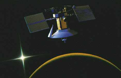
A World Explorer - August 25th, 1995.
"Ferdinand Magellan was a world explorer. Many consider him the greatest navigator of Europe's 16th century age of sea-going exploration and credit his expedition with the first circumnavigation of planet Earth. NASA's Venus probe, the aptly named Magellan spacecraft shown above in an artist's conception, provided a global view of the poorly known surface of Venus - just as Magellan's expedition provided the beginnings of a global perspective of the Earth.
Ferdinand Magellan's expedition of 5 ships and 265 men left Spain in 1519, in search of a western route to the Spice Islands of Indonesia. In 1522, one ship and 17 men returned. NASA launched the Magellan probe on May 4th, 1989. Placed in a polar orbit, Magellan's many circumnavigations resulted in a detailed radar mapping of 98% of the Venusian surface. As pictured, the radar mapper's antenna resembles a large inverted bowl. Power for the radar was produced by the wing-like solar panels. In October of 1994, the Magellan probe entered the Venusian atmosphere and ground controllers lost contact with the spacecraft."
2 notes
·
View notes
Text
youtube
Belajar GIS & IT Tools Sekaligus, Cuan dari Komisi 50%! 🎓 Materi: QGIS, ArcGIS, Global Mapper, KeepassXC, GPS Essentials 🎁 Diskon 50-75% + Peluang Reseller
#OnlineLearning#ITdanGIS#MasterJond#GISIndonesia#DiskonKursus#QGIS2025#TrainingIT#KomisiReseller#PelatihanProfesional#Youtube
0 notes
Text
0 notes
Text
Global Mapper Crack Key + Keygen Download 2025
Global Mapper is a powerful GIS (Geographic Information System) software developed by Blue Marble Geographics. It is widely used by professionals in the fields of geography, surveying, natural resource management, engineering, and environmental science for tasks related to spatial data analysis, mapping, and geospatial data processing. Global Mapper is known for its user-friendly interface, comprehensive functionality, and support for a wide variety of geospatial data formats.
➤ ► 👉 Global Mapper Premium Crack ➤ ► 👉 Global Mapper Free 2025
1 note
·
View note
Text
Cómo encontrar un viejo tornado con Google Earth
ITA version ENG version
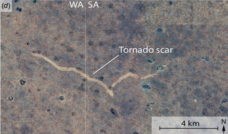
Se ha vuelto casi una costumbre investigar un nuevo lugar en internet antes de visitarlo: ya sea para decidir qué ver en una ciudad, buscar una dirección o, tal vez, utilizar imágenes satelitales para planificar la mejor ruta. Durante una de estas exploraciones virtuales, un espeleólogo, experto en cuevas, estaba revisando imágenes de Google Earth en busca de entradas de cuevas en la llanura kárstica de Nullarbor, en Australia, cuando se topó con algo realmente inusual: una cicatriz larga y clara que cruzaba el desierto por varios kilómetros. La curiosidad hizo el resto, y la imagen terminó rápidamente en manos de un grupo de investigadores que decidió investigar el misterio.
La investigación se basó en un análisis meticuloso utilizando tecnologías satelitales. Las imágenes de Google Earth permitieron identificar la ubicación y la estructura general de la cicatriz, de unos 11 km de largo y entre 160 y 250 metros de ancho. Posteriormente, con la ayuda de software como Global Mapper y datos provenientes de los satélites Landsat y Sentinel, se delimitó el período de formación entre el 16 y el 18 de noviembre de 2022, precisamente durante un evento meteorológico significativo que afectó la región.
¿Pero qué provocó esta cicatriz? La respuesta llegó al combinar imágenes meteorológicas históricas, datos recopilados de estaciones locales y observaciones de campo. Las imágenes satelitales mostraban una densa cobertura nubosa el 17 de noviembre, mientras que las estaciones meteorológicas registraban precipitaciones récord. Además, las imágenes satelitales temporales mostraron áreas inundadas con una forma circular característica en correspondencia con la formación de la cicatriz. La inspección de campo confirmó la presencia, dentro de la cicatriz, de marcas cicloidales: rastros típicos de vórtices de succión. Los investigadores ya no tenían dudas: esa cicatriz era la firma inequívoca del paso de un tornado.
Los datos indican que el tornado se movió en dirección este, girando en sentido horario con una fuerza estimada entre F2 y F3 en la escala Fujita, alcanzando velocidades superiores a los 200 km/h. Este tipo de evento es raro en la llanura de Nullarbor, una región remota y poco habitada donde los tornados a menudo pasan desapercibidos. Esta combinación de aislamiento geográfico y ausencia de testigos oculares destaca el valor de las imágenes satelitales.
Eventos como este ayudan a comprender mejor el comportamiento de los tornados en regiones remotas y poco estudiadas, especialmente en Australia, donde los tornados son poco frecuentes. Con el tiempo, acumular suficientes imágenes podría incluso llevar al desarrollo de análisis automatizados basados en inteligencia artificial para detectar tornados en áreas áridas. Mejorar nuestro conocimiento de estos fenómenos no solo aumenta la capacidad de previsión, sino que también puede contribuir a estrategias de mitigación de riesgos, haciendo que las comunidades estén mejor preparadas para eventos extremos.
Así que, ¡la próxima vez que notes algo extraño en Google Earth, avísalo! ¡Hasta Pronto y Buena Ciencia!
fuente

#tornado#ciencia#tecnología satelital#clima extremo#Australia#Nullarbor#cicatrices de la naturaleza#imágenes satelitales#inteligencia artificial#prevención de riesgos#Drops of Science#noticias#ciencias naturales#blog#noticias científicas#desierto#google earth
0 notes
Text
Lowongan Kerja Ajudan Gis
Semangat pagi, PT. Bangkitgiat Usaha Mandiri (NT Corp) di sekarang ini memerlukan “Asisten GIS” untuk penempatan di Kotawaringin Timur, Kalimantan Tengah. Tanggung Jawab Pekerjaan : Melakukan pemetaan pada lahan kelapa sawit. Keahlian : – Menguasai dasar pemetaan dan toolsnya– Menguasai GPS, Arc GIS dan Global Mapper Kualifikasi : – Laki-laki. Usia maks. 35 tahun– Pendidikan min. SMK– Pengalaman…
0 notes
Text
NASA-Designed Greenhouse Gas-Detection Instrument Launches
Developed by the agency’s Jet Propulsion Laboratory, the imaging spectrometer will provide actionable data to help reduce emissions that contribute to global warming. Tanager-1, the Carbon Mapper Coalition’s first satellite, which carries a state-of-the-art, NASA-designed greenhouse-gas-tracking instrument, is in Earth orbit after lifting off aboard a SpaceX Falcon 9 rocket from Space Launch…
0 notes
Text
NASA-Designed Greenhouse Gas-Detection Instrument Launches
Developed by the agency’s Jet Propulsion Laboratory, the imaging spectrometer will provide actionable data to help reduce emissions that contribute to global warming. Tanager-1, the Carbon Mapper Coalition’s first satellite, which carries a state-of-the-art, NASA-designed greenhouse-gas-tracking instrument, is in Earth orbit after lifting off aboard a SpaceX Falcon 9 rocket from Space Launch Complex 4E […] from NASA https://ift.tt/xp5iN4v
1 note
·
View note
Text

Adsorptive regolith on Mars soaks up water, updated model shows
Mars, the next frontier in space exploration, still poses many questions for scientists. The planet was once more hospitable, characterized by a warm and wet climate with liquid oceans. But today Mars is cold and dry, with most water now located below the surface. Understanding how much water is stored offers critical information for energy exploration, as well as life sustainability on the planet.
A research group from Tohoku University has helped shed light on this by improving an existing Mars climate model. The enhanced model accommodates the various properties of Martian regolith, or the loose deposits of solid rock that comprise Martian soil. The study is published in the Journal of Geophysical Research: Planets.
Mirai Kobayashi says current models fail to account for the fact that laboratory experiments have demonstrated that the water-holding capacity of the regolith is strongly influenced by its adsorption coefficient.
"Models to date that estimate the distribution of surface and subsurface water on Mars assume that its regolith properties are uniform. This contrasts with observations made by orbiters and landers, which suggest that Martian regolith has globally non-uniform physical properties."
The model estimated Mars's subsurface water distribution down to 2 meters from the surface. Like a sponge, highly absorptive regolith in Mars's mid- and low latitudes retains substantial amounts of absorbed water. Some of this water, the findings showed, remains on the surface of the regolith as stable adsorbed water.
The study also showed that the soil on Mars could keep ice near the surface in the middle and lower areas because water vapor moves more slowly there. This means the soil helps trap water for a long time by slowing down how water vapor spreads, which is important for understanding the change in water on Mars over time.
"Our study stresses the importance of incorporating absorption and inhomogeneity of Martian regolith in forecasting Mars's surface water," says Takeshi Kuroda, who led the team alongside Kobayashi, Arihiro Kamada and Naoki Terada. "The model can also be used to study how water on Mars has changed, and how it may have moved deeper underground near the planet's mantle."
With several Mars exploration missions underway, including the Japan-led Martian Moons eXploration (MMX) and the international Mars Ice Mapper (MIM) projects, the model is expected to complement further studies that can lead to subsurface water maps of Mars.
IMAGE: The schematic diagram of the model and results. Credit: Mirai Kobayashi
5 notes
·
View notes
Text
Recogida de Puntos de Control en Tierra Utilizando Global Mapper Mobile
Global Mapper Mobile facilita la recolección eficiente de datos directamente desde dispositivos móviles, permitiendo a los usuarios registrar fácilmente puntos de control en el terreno y otras características significativas in situ mientras recopilan imágenes de dron para su procesamiento a través de la herramienta Pixels to Points en Global Mapper de escritorio. Accesible en plataformas iOS y…
0 notes