#Gnss
Explore tagged Tumblr posts
Visit Tumblr Blog
Explore Tumblr blogs with no restrictions, modern design and the best experience.
Last Seen Tumblr Blogs


Fun Fact
The Tumblr app for Google Glass was released on May 16, 2013.
Text
thanks for ur help 🤍🤍.
#cute#so cute#gnss#cats#cats of tumblr#cute cats#kitty#kitties#kittens#beautifull#gorgeous#beauty#perfect#my love#explore#fyp#tumblr fyp#fypツ#fypシ
24 notes
·
View notes
Text

u‑blox NEO-F9P RTK samples arrived 📍🌎 🗺
#adafruit#electronics#ublox#gnss#gps#tiny#iot#location#nav#connecteddevices#aerospace#automotive#marine#smol
2 notes
·
View notes
Text
Lietuva su kolegomis sprendžia kaip apginti Lietuvą nuo Rusijos ir Baltarusijos navigacinių sistemų atakų
Susisiekimo ministras Eugenijus Sabutis kartu su dar dvylikos Europos Sąjungos (ES) šalių transporto ir telekomunikacijų ministrais bendru laišku kreipėsi į Europos Komisiją, ragindamas imtis veiksmų dėl vis dažniau pasikartojančių hibridinių atakų iš Rusijos ir Baltarusijos – Pasaulinės palydovinės navigacijos sistemos (GNSS) ryšio trikdžių ES šalyse. Lietuvos inicijuotame kreipimesi taip pat…
0 notes
Text
SciTech Chronicles. . . . . . . . .Jun 2nd, 2025
#microbe-produced#scfa#gut-heart#cardio-protection#uplift#drought#GNSS#Quathlamba#“trial and error”#habits#value-based#APE#Altiplano#DNA#Chibchan#indigenous#approval#disapproval#“social evaluation”#“state self-esteem”
0 notes
Text
#GNSS#PNT#Positioning#Navigation#Timing#ElectronicWarfare#VIAVISolutions#Innovation#DefenseTechnology#Aviation#EmergencyServices#powerelectronics#powermanagement#powersemiconductor
0 notes
Text
LiDAR Market Will See Strong Expansion Through 2031
Allied Market Research, titled, “LiDAR Market Size by Type, Component, Application, End User, and Region: Global Opportunity Analysis and Industry Forecast, 2022–2031," The lidar market was valued at $1.1 billion in 2021, and is estimated to reach $7.8 billion by 2031, growing at a CAGR of 21.3% from 2022 to 2031.
Light detection and ranging (LiDAR) is a remote sensing technology that uses laser light to measure distances and create 3D models of the environment. LiDAR works by emitting a laser pulse towards a target and measuring the time it takes for the pulse to reflect the sensor. This process is repeated many times per second, creating a 3D point cloud of the target area.
Increase in demand for 3D imaging systems and automated systems required in LiDAR as well as a surge in the use of aerial sensing applications act as the key driving forces of the global LiDAR market. However, some of the limitations of the LiDAR system include its higher cost when compared to RADAR systems and its lack of awareness about its potential for mapping objects and structures.
The growth of global LiDAR is majorly driven by the automated processing in LiDAR systems paired with the enhanced performance of LiDAR systems compared to other technologies script. Moreover, the rise in demand for 3D imaging coupled with the surge in the adoption of LiDAR across various industries is expected to drive market growth. However, the lack of awareness about LiDAR across emerging economies is acting as prime restraint of the global market. On the contrary, the expansion of LiDAR applications in new industries and markets is anticipated to provide lucrative opportunities for the LiDAR industry during the forecast period.
According to LiDAR market analysis, the aerial segment was the highest contributor to the market in 2021. Civil engineering and forestry and agriculture collectively accounted for around 53.5% market share in 2021. The surge in prime players' initiatives to develop and deploy next-generation creating high-resolution digital elevation models (DEMs), 3D terrain maps, and vegetation surveys globally has led to the growth of the LiDAR market growth.

In 2021, the pandemic had a mixed impact on the LiDAR market. While it initially caused supply chain disruptions and delayed deployments, an increase in demand for automation and remote sensing technology fueled the market growth. Furthermore, LiDAR technology such as LiDAR scanners, lasers, and others are becoming increasingly important in industries such as transportation, agriculture, and construction due to the shift toward digital transformation and sustainability.
By type, the aerial segment dominated the LiDAR market trends in 2021 and is expected to dominate the market during the forecast period. In the case of components, the laser segment accounted for the major share of the LiDAR market. As per the end-user sector, the civil engineering segment accounted for the major share of global LiDAR industry trends, owing to a surge in demand from emerging markets globally. By application, the market is analyzed across corridor mapping, seismology, exploration & detection, and others. Region-wise, North America holds a significant share of the global LiDAR market, owing to the presence of prime players in this region. The U.S. dominated the LiDAR market in North America LiDAR market.
KEY FINDINGS OF THE STUDY
In 2021, the aerial segment accounted for maximum revenue and is projected to grow at a notable CAGR of 17.7% during the forecast period.
The laser segment was the highest revenue contributor to the LiDAR market size in 2021.
Civil engineering and forestry & agriculture collectively segments collectively accounted for around 53.5% LiDAR market share in 2021.
North America acquired a major share of the LiDAR market with an industry share of 20.5% in 2021.
The rise in investment by prime players and government agencies to develop next-generation aerospace and defense solutions has led to the growth of the LiDAR market. The key players operating in the global LiDAR market include Leica Geosystems AG, RIEGL Laser Measurement Systems GmbH, Mira Solutions, Inc., FARO, Firmatek, LEOSPHERE (Vaisala), Velodyne Lidar, Inc., Aerometrex, Yellowscan, and SICK AG. These players have adopted various strategies such as product launches, collaborations, partnerships, joint ventures, and acquisitions to strengthen their foothold in the market. For instance, in 1 December 2022, FARO Technologies, Inc. announced the acquisition of SiteScape, an innovator in LiDAR 3D scanning software solutions for the AEC and O&M markets. SiteScape enables LiDAR-equipped mobile devices to easily capture indoor spaces digitally, providing a readily available entry point to scanning physical spaces for a broad range of applications. In addition, on 11 October 2022, Velodyne Lidar, Inc. announced a multi-year agreement to provide its lidar sensors to Yamaha Motor for Eve Autonomy, a joint venture between Yamaha Motor and Tier IV, Inc. Eve Autonomy’s autonomous goods transport service Eve Auto, provides logistical support for factories to improve efficiency and safety.
#lidar#ali lidar#lidar mapping#lidar technology#lidar market#gps#gps tracker#gps and navigation#gps device#gnss
0 notes
Text
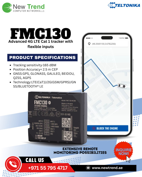
FMC130
Features Tracking sensitivity-165 dBM Position Accuracy< 2.5 m CEP GNSS:GPS, GLONASS, GALILEO, BEIDOU, QZSS, AGPS Technology:LTE(CaT1)/2G(GSM/GPRS)/GNSS/BLUETOOTH® LE
For more information, Visit: https://newtrend.ae/ 📞 Live chat: +971 507542792
#FMC130#GPS#TrackingDevice#Telematics#FleetManagement#LTE#GNSS#BluetoothLE#VehicleTracking#NewtrendUAE#AssetTracking#IoT#SmartTracking#TechSolutions#DubaiTech#GSM#GLONASS#BEIDOU#GALILEO#QZSS#Cat1#AGPS#NewtrendTech
0 notes
Text
Advanced Gnss system for fleet tracking and fuel saving

Introduction
The coolant oil supply industry is under pressure, with customers expecting dependable service, timely deliveries, and improved tracking. A lot of manufacturers are still stuck with old systems that can't stop waste, theft, or delays, which ends up driving up costs and frustrating customers.To stay competitive and improve service, businesses need smarter technology to handle these challenges.
Solving Gnss Tracker Failures for a Water/Chemical Delivery Fleet
Solving GNSS Tracker Failures for an Oil Delivery Fleet
Client Challenge: When Standard GPS Fails, a Need for Smarter Fleet Tracking Solutions
The client needed a smarter system to track everything in one place—routes, oil dispensed, and fuel usage. Their existing GPS trackers couldn’t provide the level of accuracy and control they needed.
Oil Tracking—Without tracking oil deliveries in real time, it was hard to manage usage, stop theft, and confirm that the right amount was delivered.
Fuel Monitoring — Fuel losses were adding up, and without proper tracking, it was impossible to control costs or identify misuse.
Truck Location Tracking - Delays and unpredictable delivery times were causing trouble. They needed a better way to track trucks and make sure deliveries arrived on time.
Solving the Challenge of Incomplete Data from Low-Performance GNSS Tracking Systems. They needed a smarter system to save costs, improve functionality, and deliver better service.
The Problem: Basic GNSS Trackers Consistently Failed
The client was using basic GPS trackers, but they didn’t hold up in real-world use. Devices kept failing, which made the whole system unreliable.
The trucks had voltage spikes that damaged the devices.
Jumpstarting caused the circuits to burn out.
Tracking often failed, showing wrong or missing location data.
Oil was getting wasted or stolen without being noticed.
These problems made it hard to track deliveries, raised costs, and caused delays. The client needed something more reliable, so they chose a custom system built for accuracy and durability.
How We Fixed It: We Solved the Real-World GNSS Tracking Problem
At Auckam Technologies, we built a custom GNSS tracking system designed for real-world use. Designed for everyday challenges — dependable tracking you can trust. Here’s what you get.
Voltage spikes in trucks damaged the devices
Trucks often experience sudden voltage surges—especially when the engine starts. The devices were failing because of power spikes. Now, they’re protected with parts that block extra voltage and current.
Jumpstarting the trucks caused the circuits to burn out and the system to fail
Jumpstarts created high-power surges that burned out the tracking circuits. This led to complete device failure and replacement. We designed protection circuits to handle jumpstart surges and prevent damage.
Tracking problems caused the location data to be missing or wrong
The GPS often lost the signal or gave incorrect locations. This made real-time tracking unreliable. We improved the antenna circuit for better accuracy and tested different placements for stronger signal performance.
Wastage and theft of the oil to be deliveredWe added a precision flow meter and a control valve to track the exact amount of oil dispensed. The data is logged along with the location, so the valve can be shut off once the set amount is delivered—reducing wastage and preventing theft.
The Result: A Smarter, Safer Fleet
With Auckam Technologies’ tailored GNSS solution, the client finally solved their biggest tracking challenges.
No more missed signals—the GPS tracks perfectly, whenever and wherever you need it.
Full control—accurate flow meter data showed exactly how much fuel was left, removing all the guesswork.
Lower maintenance costs— Less downtime, fewer failures, and lower repair costs – a more cost-effective solution for your business.
Better delivery experience—With reliable tracking, your orders arrived faster and without any issues.
Final Thoughts: Transform Fleet Operations with Powerful Custom GNSS Tracking Auckam Technologies’ GNSS tracking system helped reduce downtime, cut costs, and boost delivery performance.
What We Achieved:
Reliable, Real-Time Tracking
The system provided precise location data in real time, enabling continuous fleet monitoring and optimized route planning for better efficiency.
Reduced Downtime and Lower Costs
Fewer maintenance issues and less frequent device replacements led to reduced downtime and overall operational costs.
Smarter Delivery Monitoring
With real-time GPS tracking, delivery speed improved while reducing errors and ensuring more accurate and timely service.
Improved Efficiency
By monitoring fuel and oil levels in real time, we minimized theft and waste, ultimately boosting fleet performance and saving costs.
Why Choose Auckam Technologies?
We solve real problems.
Our team builds tracking and monitoring systems that actually work in tough, everyday conditions—no fluff, just solid performance.
Get Started with Better Tracking Today
Is your current tracking system holding you back? It’s time for an upgrade.
Our custom GNSS solutions are built to meet your specific needs, Boosting Fleet Performance, reducing costs, and giving you complete visibility.
Contact us today
Let’s connect and create a solution that fits your workflow and boosts your performance.
Reference
Tomorrow starts today! Explore next-gen solutions designed to make the world smarter. Click for more! www.auckam.com
Let’s stay connected—follow us on your favourite social media platforms today: LinkedIn, Instagram, Facebook, Twitter, and YouTube.
#FleetTracking#GNSS#FuelSaving#FleetManagement#Telematics#IoTSolutions#VehicleMonitoring#SmartLogistics#TransportationTech#FleetOptimization
0 notes
Text
The Philippine Army (PA) adds to its growing Arsenal of Precision Guided Munitions (PGM) with the release of the Notice to Proceed (NTP) last Year of 2024 of the guided Ammunition of their Autonomous Truck Mounted-howitzer System (ATMOS) units, which will likely be the “Silver Bullet” Product of Elbit Systems.
This was initially released as an Article last January 6, 2024 at https://therhk111militaryandarmspage.blogspot.com/2025/01/philippine-army-acquires-silver-bullet-guided-ammunition-system-atmos-howitzers.html
#philipinearmy#silverbullet#guidedammunition#howitzer#autonomoustruckmountedhowitzersystem#atmos#noticetoproceed#ntp#elbitsystemslandlimited#precisionguidedmunitions#pgm#dualmode#globalnavigationsatellitesystem#gnss#unitedstates#globalpositioningsystem#gps#circularerrorprobable#cep#m71#tubelaunchedopticallytrackedwirelessguided#tow2a#missile#donaldtrump
0 notes
Text
#Cisco#Multielement#9in1#lte#wifi#gnss#antenna#soniccomponents#amazon#ebay#walmart#newegg#alcatel#lucent#nokia#sharp#@cisco
0 notes
Text
What's better than ice cream? Re-visiting a mid-2020 design! ZED-F9P RTK board 🍦🔄🎯🛰️
nothing is as satisfying as a scoop mint chocolate-chip on a hot day…except maybe finishing a board design from 2020! this ZED-F9P is an RTK 'real time kinematics' board https://blog.adafruit.com/2020/06/08/eye-on-npi-u-blox-c099-f9p-application-board-for-zed-f9p-gnss-rtk-module-eyeonnpi-adafruit-digikey-digikey-ublox/ that can do high precision location. kinda like a GPS/GNSS but with centimeter accuracy. they're not cheap but there's really nothing else that works as well. these are modules from uBlox and they're finally in good supply at DigiKey https://www.digikey.com/short/8v5rjw15 . our shield design is nice and spacious and would be a great fit for a Metro ESP32-S2 https://www.adafruit.com/product/4775 which has DC, USB and LiPoly input. we'll be sending out for prototype PCBs this week!
#Adafruit#GNSS#ZEDF9P#RTKBoard#HighPrecisionLocation#GPS#uBlox#DigiKey#PrototypePCB#MetroESP32S2#IceCreamDay
6 notes
·
View notes
Text
#STMicroelectronics#satellite#automotive#smarttransportation#GNSS#AutomotiveTech#IndustrialAutomation#PrecisionPositioning#electricvehiclesnews#evtimes#autoevtimes#evbusines
0 notes
Link
#AutonomousVehicles#autonomy#AWS#BlueCruise#Bosch#cloud-basedGNSS#Ford#Futurride#globalnavigationsatellitesystem#GNSS#GNSSpositioning#ISO26262#Level3#precisepositioning#SAE#sustainablemobility#SwiftNavigation
0 notes
Text
SciTech Chronicles. . . . . . . . . . . . . . . . . . . . .Jan 22, 2025
#Neuromorphic#semiconductor#self-learning#memristor-based#Moon#LuGRE#GNSS#navigation#polycatenated#three-dimensional#chain-mail#PAM#neurons#mechanical#stretch#metabolism#vagus#memory#electrode#amygdala#hippocampus
0 notes