#Harris tarn lake
Photo


A trip to the Outer Hebrides with my cousin produced a lot of photos but these a just a few of what i consider the best :)
#isle of harris#scotland#outer hebrides#sea#seaside#waves#tarn#lake#scenery#landscape#photography#nature#sand#beach#sunset#beaches#scottish#united kingdom#ocean
22 notes
·
View notes
Photo

Treat yourself to a Golf Trip in England’s Lake District
With the reopening of Linthwaite House in the Lake District on 31st July, it’s time to treat yourself to a golf trip in one of England’s most popular holiday destinations that promises plenty of space and fresh air in the great outdoors.
Part of the Leeu Collection, the stunning hotel in Cumbria, England has teamed up with the nearby Windermere Golf Club to offer a ‘Golfing in the Lakes’ package that combines a two-night stay at the luxury property with 18 holes of golf for two at one of Cumbria’s most delightful and scenic golf courses, and a three-course set dinner at Michelin-starred Simon Rogan’s newest restaurant Henrock.
Whilst England’s largest National Park is best known for its spectacular walks around its numerous lakes and up mountains like Scafell Pike, it is also home to almost 40 golf courses making it the ideal destination to combine hiking with a round of golf or two, with both activities giving visitors the opportunity to soak up wonderful views of the surrounding landscape.
Less than a mile from Linthwaite House, the course at Windermere Golf Club offers panoramic views over Lake Windermere and across to the distant fells. Founded back in 1891, the layout was designed by George Lowe who – at the time – was the professional at Royal Lytham & St Annes (which has hosted 11 Open Championships), a course he also created. In true moorland style, each hole at Windermere follows the gently rolling and rugged character of the local terrain to create a layout that is both charming and demanding.
Though relatively short at 5,143 yards, this par 67 course presents golfers with a quite a challenge thanks to an array of blind tee shots, several elevation changes and numerous natural hazards such as rocky outcrops, abundant bracken and copses of trees that run alongside some of the fairways.
After the rigours of golf, Linthwaite House provides a tranquil retreat and all the comforts of a five star hotel. The Conservatory, Bar and Terrace are the perfect place for a light meal or early evening drink, while admiring the breath-taking views over Windermere towards Coniston. Breakfast and dinner are served in Henrock which showcases natural, seasonal ingredients in a relaxed and elegant setting.
That hotel stands in 14 acres of landscaped private gardens, which are dotted with arresting sculptures and offer a range of outdoor pursuits such as boating and fishing on the tarn (a small lake), boules, croquet and giant chess. At the end of the day, guests retire to one of the 36 luxurious, individually-designed bedrooms for a great night’s sleep in this peaceful bolthole.
Testifying to the quality of the hotel and its golf offer, Linthwaite House has been nominated in several of this year’s Luxury Lifestyle Magazine Readers’ Travel Awards including the Best Hotel for Golf category (winners will be announced in the Autumn).
Keen golfers may wish to try several of the other golf courses in the area, such as the Harry Colt parkland course at Ulverston just 15 miles away and the highly-regarded Silloth on Solway golf course, rated by Top 100 Golf Courses as the one number course in Cumbria, that is located on the coast about a 90-minute drive from Linthwaite House.
The ‘Golfing in the Lakes’ package includes two nights’ B&B accommodation, a three-course set meal in Henrock on one night and a round of golf for two at Windermere Golf Club (with scrumptious snacks to keep you going and return transfers to the club from Linthwaite House). Rates start from £615 for two people sharing a double room; book online at https://leeucollection.com/UK or email [email protected] or call +44 (0) 15394 88600, quoting “Leeu Golf”.
1 note
·
View note
Photo


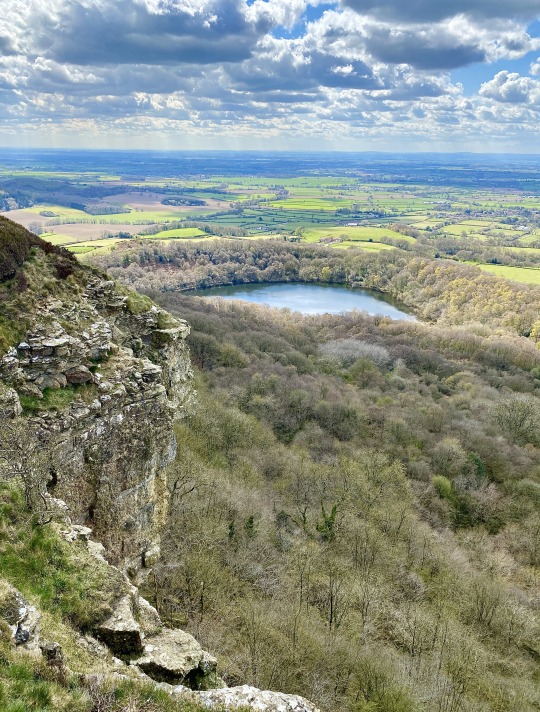
🥾 Walking with Paul Beal
🐟 GORMIRE LAKE
🗺 North York Moors, Northern England
A natural lowland lake below Whitestone Cliff on the west side of Garbutt Wood. The lake has no inflow or major outflow of water, and is thought to be filled by an underground spring and drained by a limestone channel at the base of the cliff face to the east. The lake is also known as White Mere, Lake Gormire or just Gormire, and the name Gormire means ‘filthy swamp’.
Gormire Lake was formed over 20,000 years ago by glacial erosion. When an ice sheet pushed its way between the Pennines and the North York Moors it bulldozed the soft earth away and carved the cliffs at Whitestone, and the left-over mud stopped the water’s escape and formed the glacial lake. It is the fourth largest of the natural lakes in Yorkshire (the other three being Hornsea Mere, Malham Tarn and Semerwater).
The lake is the setting of several myths. One is that of a knight known as Sir Harry Scriven who conned the Abbot of Rievaulx Abbey into letting him ride his horse, a white mare. The knight and the abbot rode on from an inn and as they did so, it turned into a race. The abbot then changed into the devil, which caused such panic in the knight that he couldn’t stop the horse and himself plunging into Gormire Lake from the top of the cliff. The ‘devil’ was then seen to jump into the lake after them and the boiling effect of the devil in the water is what is said to have caused the darkness of the lake to this day.
👉 https://www.paulbeal.com/routes-and-photos/north-york-moors/kilburn-white-horse-and-sutton-bank/
👍 #GormireLake #NorthYorkMoors #NorthYorkshire
0 notes
Text
Top 10 Summer Destinations in the UK
1. London
If you are looking to immerse yourself in the busyness of the hustle and bustle of the city then visit London. It offers the iconic London Eye, Big Ben, and Westminster. Overcome your fear of heights, visit the shard, or enjoy the beautiful Gherkin and see its beautiful architecture. If you’re looking to shop, then enjoy yourself in Oxford street as you lose yourself in the many retail stores it has waiting for you. Eat away and explore the diversity of London as you taste away in London’s Borough Market or Camden market.
2. Lake District
If you’re looking for a quiet getaway to cherish mother nature, then Lake District is the place for you. If you're feeling energetic why not hike up Lake district and camp amidst the beautiful view of the Lake. Lake District National Park is popular for its stunning scenery, abundant wildlife, and cultural heritage. Its special qualities include: Cool, clear lakes, tarns and rivers - nationally important stretches of water for their range of habitats, and species such as vendace, charr, crayfish, and schelly.

3. Cornwall
Cornwall is popularly known for its Celtic history, but it also offers a coastline located in the southwest of the UK. Let’s be frank, charming seaside trips are amazing. I mean, at the first sight of (sunshine or dry even dry weather for that matter) us Brits rush to the sea. It’s in our blood! Especially in Cornwall, where there’s a whole heap of pretty seaside towns and coastlines to explore. If you’ve never had a seaside holiday in England before then you’re in for a beautiful and mouth-watering treat. Most are filled with some of the tastiest fish and chip shops (add a few splashes of vinegar), lots of tearooms, and plenty of local pubs (a favourite once the sun starts to set) – with Cornwall being of no exception. With all the little hamlets, rugged rocks, and the kind of beaches that make you want to stay all day – you won’t want to leave this gorgeous area of England.
Some of the popular routes are
Glasgow taxi
London taxi
Norwich taxi
Abingdon taxi
Aldershot taxi
Andover taxi
Ashford taxi
Aylesbury taxi
Banbury taxi
Barnstaple taxi
Basildon taxi
Basingstoke taxi
Bath taxi
Bedford taxi
Bicester taxi
Birmingham taxi
Blackburn taxi
Bolton taxi
Bournemouth taxi
Bracknell taxi
4. Bath
Located in Somerset, Bath is rich in culture and history. It is the largest city in the county of Somerset, known for and named after its Roman-built baths One of the popular places to visit in Bath is the medieval Bath abbey along with its roman built bath. If you're exploring architecture, then why not try the royal crescent, an arc formed by Georgian townhouses designed by John Wood. Soaked in history Bath has plenty of places to visit, from The Circus and Stonehenge, Bath’s Many Crescents, and already mentioned Bath abbey.
5. Bournemouth Dorset
A genteel Victorian seaside resort on the South Coast of England, Bournemouth cultivates a polished, stately image. This has much to do with its many gardens, planted with sub-tropical species like palms and ferns that thrive in the town’s warmer microclimate. Bournemouth has some of the warmest sea temperatures in England, on seven miles of coast that includes four Blue Flag beaches, held as some of the best England has to offer. These beaches are hemmed by green cliffs, and you can use funicular railways built in Bournemouth’s Victorian heyday to get down. In a few spots, the cliff is broken by a ravine, known on the South Coast as a chine, and often landscaped with gardens. From the Hengistbury Head Beach to the Oceanarium to the West Cliff lift to the ever-popular Bournemouth Pier, it is full of eye-catching spectacles.
6. Edinburgh
The capital of Scotland, Edinburgh has got to be one of the most mysterious cities in Europe. Its dark, medieval walls hold so many secrets, most of which we probably don’t even know about boasts itself for its well-known Edinburgh castle. Uncover the history and visit the Scottish crown Jewel in the Royal places well as the Scottish national war memorial and the famous stone of destiny. Edinburgh is touted as the greenest city in the United Kingdom, the place exudates lush trees and plants everywhere. It is also known for the widely popular Edinburgh Fringe festival fare, the largest arts festival globally. All in all, it is a must summer destination in the UK.
7. Stonehenge in Salisbury
Stonehenge, prehistoric stone circle monument, cemetery, and archaeological site located on Salisbury Plain, about 8 miles north of Salisbury, Wiltshire, England. It was built in six stages between 3000 and 1520 BCE, during the transition from the Neolithic Period to the Bronze Age. As a prehistoric stone circle, it is unique because of its artificially shaped sarsen stones (blocks of Cenozoic silcrete), arranged in post-and-lintel formation, and because of the remote origin of its smaller bluestones from 100–150 miles away, in South Wales. Quench your thirst in history as you visit the world's oldest heritage site. Originally known as a place of worship it is now a popular tourist site. Salisbury holds one of the most popular cathedrals that goes far back to the Magna Carta.
8. Jurassic Coat
The Jurassic Coast is a World Heritage Site on the English Channel coast of southern England. It stretches from Exmouth in East Devon to Studland Bay in Dorset, a distance of about 96 miles, and was inscribed on the World Heritage List in mid-December 2001. The word Jurassic makes everyone think of dinosaurs. Yes, you won't be seeing dinosaurs but you can discover fossils from nearly 92 million years ago. With the cliff slowly eroding more and more fossils are released so be the first to set eyes on these fossils. Why not make the most of your day with places such as Durdle Door and Old Harry’s Rock why not make the most of your day.
9. St Michael’s Mount Cornwall
This tidal island is one of the marvellous festival fares in the UK. The island is a civil parish and is linked to the town of Marazion by a man-made causeway of granite setts, passable between mid-tide and low water. The legend that coexists with it says that giants still inhabit the cave on the island. Go see for yourself whether this is just a legend or whether the existence of such giants can be proved.
10. Bristol Clifton suspension bridge
Located in the Southwest of England this city encompasses the river, Avon. Its wealthy maritime history and M shed museum allows you to discover the social and industrial heritage. The Clifton Suspension Bridge is a suspension bridge spanning the Avon Gorge and the River Avon, linking Clifton in Bristol to Leigh Woods in North Somerset. Since opening in 1864, it has been a toll bridge, the income from which provides funds for its maintenance. The suspension bridge built by Isambard Kingdom Brunel is a recognizable structure with its spectacular view of the Avon Gorge is a must-see.
0 notes
Text
Book Review:
The Plague Dogs by Richard Adams
by Connor Thomas
Photo credits: Jo-Anne McArthur / We Animals, Ben Hunt / Vegan Night School
From the first page, the reader is submerged into a world they have likely never imagined before. I encourage you to hold your breath, keep treading water and hear what the hounds have to say.

Accidently finding themselves setting paw in a land untamed by humankind, Snitter and Rowf spend the early winter months roaming the sparsely populated fells, tarns and mountain ranges of the stunning, yet brutal, Lake District. In an experience far from any reader’s hiking trip to the Lakes with their family and friends, Richard Adams requires the reader to step into the world of mentally ill fugitive animals on a quest to either find ‘proper’ masters or become feral. This story blurs the lines of fiction and reality, finding a ridge from which the reader can question our anthropocentric view of the world through the dialogues of both animal and human. Filled to the brim with real places, people and practices (along with a fictitiously placed laboratory). The book will leave you desperate to follow in the snowy pawprints of the dogs and follow the scent of this emotional and morally challenging mountain trail that uses anthropomorphism as a key to understand the plight of the individual non-human animal.

Snitter, a fox terrier, after spending the majority of his life in a different kind of world, finds himself in unfortunate circumstances. He awakens in a research laboratory, with not much more than a plaster covering a gaping hole in his head. The origin of which the reader learns about very quickly, yet every human character who meets Snitter cannot fathom the source of such a head wound. He is a character I grew to love. He knew a world of lampposts, letterboxes and love beforehand but cannot figure out how to return to that world, until, an opportunity arises for Snitter to temporarily share a cage with a large and fierce black mongrel known as ‘Rowf’. We first meet Rowf in deep water and this proves to be a challenge for him throughout the story (skimming the edge of deep cold tarns of the Lake District), until his fear subsides in search of a better world for animals. Action before forethought is how Rowf lives his life; he is a fighter, only ever knowing the touch of evil hands. He manages to keep the companionship of the two hounds strong through adopting an unexpected patience for Snitter’s powerful seizures and loud nightmares. This loyalty is stretched when a third animal enters the trail.
Throughout their late-night trekking they meet many animals, some become prey, others turn out to heed indirect messages of importance, but none spend as much time with the wannabe feral animals as their Geordie Lake District guide: The Tod. The Tod is cunning and clever yet hard to understand, which leads both dogs and reader in a position of distrust. Only ever knowing a feral life spent with a bounty on his head, wanted by the red coats and their hounds, the Tod proves to be a valuable asset in the quest to defeat the necessity of hunger and avoid the searching eyes of man. But how long is a fox’s tale? Will trust between the dogs and the fox solidify in time to get away from the angry search parties of farmers? Or will buzzard and crow come to pick the remains of the three in the cold wintery sunrise?

The human characters’ narratives are interweaved in a linear form with the dogs’ tale. We meet a resourceful journalist Digby Driver, a man who both helps and hinders the dogs’ chances through sensationalist newspaper articles and the manipulation of public opinion. Driver proves to be an asset to the reader; teasing out the details we need to complete the full picture, though using these same details to highlight a profitable story for the ‘London Orator’. Similar to the real world in which the majority of animals are only known to us through the perspectives of humans, both defenceless Snitter and Rowf have no awareness of a man creating their (hi)story. Will he hinder the dogs’ chances of survival or will his story assist their quest for a different life?
Another man, Stephen Powell, battles with the dichotomy of human progress through animal experimentation and the plight of animals in order to gain freedom from unnecessary harm. Innocent, timid and caring in every aspect of his home life and thorough, disciplined and rigorous in every part of his job as a scientist, he finds himself weeks away from becoming an established scientific officer. As in every morally challenging book, an unexpected situation occurs, and the research station is put under pressure from the public eye. Powell is thrown into a position which puts his career on the line and tests his moral flexibility, helping the reader to understand what it is like to be an animal researcher. We are thrown into a babbling brook of morality when Digby Driver manages to tease information out of Powell over a few pints at a local pub. What impact will Powell’s words and actions have on the dogs and what impact will the dogs have on Powell? (N.B. The experiments described in this book have all been real experiments carried out on animals throughout the world. One widely known from the study of psychology: Harry Harlow and the Rhesus Macaques – The social isolation experiment).

The book intensifies towards the end with multiple climaxes that will have your heart squelching with hope and pain as if you were watching a live theatrical version with real animals. An ever present question forms in the readers’ mind which is hinted throughout the book and is encapsulated by Major Awdry: ‘…It occurs to me that creatures living entirely in the immediate present, through their physical senses, may suffer more rather than less intensely than we do.’ What of a dog’s life then? Stumbling into an empty vintage train carriage which has been deserted by humans in the winter off season, Rowf tells Snitter of his desire to have been a ‘good dog’ for the whitecoats and Snitter tells Rowf that the whitecoat masters didn’t want Rowf ‘…to be a good dog…’ for he says: ‘I don’t know what they did want. I don’t believe they know themselves.’ Will Rowf find a master without a white coat who keeps him away from the metal water?

This book has been an incredible journey for me. I endeavour to trek the same paths as The Plague Dogs with Ben, Oscar and Freya (man, dog and dog) at some point in the future. Adams’ critical view of our anthropocentrism is hashed out on the peaks of the Helvellyn range for all who are willing to read, and read, I suggest you do! Delve into the animal world and find out why Snitter and Rowf think: ‘It’s a bad world for animals.’
#theplaguedogs#richardadams#bookreview#veganbook#vegan#animalrights#animalrightsbook#vivisection#dogs#cutedogs#lakedistrict
0 notes
Text
Mount Kenya Climb-Chogoria Out Chogoria 5 Days

Program Highlights
Duration: 5 Days
Category: Kenya Trekking
Destinations: Mt Kenya
Major Attractions:
Vegetation zones and Mt Kenya
Tour Guides Language:
English, Spanish, French, German, Italian
For other languages please send a special request prior to your safari -additional fee may apply.
Start in: Nairobi
End in: Nairobi
Recommended Packing list: Camera with enough zoom and memory space and extra batteries, binoculars, light clothes, safari boot, mosquito repellents, sunhat, sunglasses with UV radiation filtering etc.
Additional note:
Porters will escort and guide you all your climbing along the mountain
Itinerary Description
Day 0: Arrival, Tour Briefing and Resting
You will be picked up from the airport in Nairobi ( Jomo Kenyatta International Airport) and be transferred to the booked hotel in Nairobi
Get the safari general briefing from the prepared safari consultant/guide
Dinner and overnight stay at your booked hotel in Nairobi
Day 1: Drive from Nairobi to Mt. Kenya for a climb
Pick up from hotel at about 0800. It's then about 3 1/2 hours from Nairobi to where we collect the porters and guides (as required)
Into the Mt. Kenya forest for the 22 km drive to the Park Gate at 2,850m
Dependent on road conditions, these 22 km have been known to take all afternoon to do and in really wet conditions it is possible that the top four or five km may be impassable
Night, dependent on clients wishes, at the Meru Mt. Kenya Banda's or at roadhead a further 7 km from the Park Gate
Day 2: Climb Mt. Kenya via Ellis to Stream Bank
After breakfast and sorting of porter loads we set off up the mountain at a nice and easy pace
A slightly longer walk via Lake Ellis gives scenic views of Mugi, Ithunguni and the Giants BilliardsTable, whilst if we follow the river near roadhead, upstream for about 3 km, the foreground scenery and flora is particularly beautiful
Lunch by the stream banks then it's time to cut up the left hand hillside to our camp at about 3,600m, well away from any of the more "touristy" areas.
Day 3: Climb to Chogoria then to Minto’s Hut
From our campsite, we continue to move up through the moorland zone
As this area of the mountain is still off the beaten track, there are no paths to follow, and on each trip we vary the area we walk across
After about an hour, traverse left and join a ridge (slight path to follow) and join the normal Chogoria route to Minto's Hut after about 4 hour walking
Lunch at a small stream crossing then 45 min on to a camp near Minto's Hut and next to one of the tarns
Very short afternoon walk over to superb views across to "The Temple" and down to Lake Michaelson
Day 4: Climb from Minto’s Hut to the Summit then descend to Bandas
After pre dawn breakfast leave Mintos Hut for the summit passing near the Simba Tarn and Harris Tan to Point Lenana which is appproximately 4 - 5 hours
After the sunrise at 6.30 and nice views of Kilimanjaro and the Coast line descend back to Mintos for full breakfast and thereafter descend to Meru Mount Kenya Lodge(Bandas) having our lunch at the Roadhead
Dinner and overnight at the Bandas
Day 5: Descend to Chogoria then after drive to Nairobi
After breakfast walk for 15km downhill through the denses rain and bamboo forests to connect the 4WD jeep to Chogoria Town
Then after lunch at Chogoria drive back to Nairobi for your next destination
Read the full article
0 notes
Text
Australia’s horrific fires may permanently change the country’s landscape
A koala yells out during last month's bushfires in southeastern Australia. (Andrea Izzotti/Deposit Photos/)
Grant Williamson is a research fellow in environmental science at the University of Tasmania. Gabi Mocatta is a research fellow in climate change communication at the University of Tasmania. Rebecca Harris is a climate research fellow at the University of Tasmania. Tomas Remenyi is a climate research fellow at the University of Tasmania.
This story originally featured on The Conversation.
As bushfires in New South Wales, Australia, are finally contained, attention is turning to nature’s recovery. Green shoots are sprouting and animals are returning. But we must accept that in some cases, the bush may never return to its former state.
We’ve all read the devastating figures of destruction this fire season. More than 11 million hectares of land burned across the country over a period of about six months. There is some evidence more than one billion animals perished.
We can take some heart in the regenerative power of the Australian bush. However, when we read of “recovery” in the media, we feel we must clarify what that might actually look like.
While Australia’s environment has evolved to adapt to fire, our research shows we can no longer assume it will recover completely.
A fiery future
We are scientists and social science researchers who work in trans-disciplinary climate change projects, liaising with park rangers, farmers, policymakers, emergency services, and local government.
Our work involves scoping future challenges in land management and developing a range of plausible future climate scenarios for south-east Australia.
Our experience told us something like this catastrophic climatic event was possible, but as researchers we weren’t prepared to see such an inferno this summer.
Although fires are natural in Australia, they’re now occurring at an unprecedented frequency and intensity in areas that, historically, did not burn. This new regime does not allow the effective recovery of natural systems to their pre-fire state.
Alpine ash to ashes
Fires in alpine ash forests (Eucalyptus delegatensis) are a good example of this.
Unlike many eucalypt species which can re-sprout after fire, this species’ only means of recovery is through germination via a seed bank in the canopy, and rapid germination and growth of seedlings after fire.
Multiple fires in quick succession kill seedlings before they reach maturity, disrupting the tree’s reproductive cycle and leading to local extinction of the species in the landscape.
Alpine ash forests have endured repeated fires in recent years. In 2013, a blaze in Victoria burnt more than 31,000 hectares of the Alpine National Park.
Vast areas have been burnt again in this season’s fires in the same places. Research reveals climate change is increasing the frequency and intensity of fires in the Australian Alps.
This ecosystem will not recover. It will instead transition into a new, different ecosystem, and many species which evolved to live in the original habitat, such as the alpine ash, will no longer be supported. They will be replaced by other vegetation types, such as other eucalyptus woodland, shrubland,` or grassland.
Along with some eucalyptus trees, Australian flowering grass trees are pyrophytic plants, which means they are adapted to survive in fire-prone habitats. (Natalie Maguire/Flickr CC/)
No more refuge
To further illustrate this point, take the Tasmanian pencil pine (Athrotaxis cupressoides).
This slow-growing conifer native to Tasmania can live for up to 1,000 years. They are found in Tasmania’s highlands and sub-alpine regions—historically a Tolkien-esque landscape of moss and emerald green cushion plants, studded with thousands of tiny mountain lakes, called tarns.
But large fires across Tasmania’s pencil pine habitat in recent years, including those in 2016, reduced hundreds of isolated pencil pine communities to blackened skeletons. The stands of trees that remain are struggling to survive in a drying and warming climate.
All this is occurring in areas that historically did not experience fire, which allowed a suite of ancient, fire-sensitive species to persist.
As climate change worsens, the pencil pine will be restricted to even smaller areas. Higher temperatures and increased fuel loads increase the likelihood of destruction by fire. Areas where pencil pines have historically been protected will diminish in number and size.
Irreplaceable loss
In these cases and many others, animal species relying on these trees and their ecosystems are profoundly affected.
Well before the latest fires, Australia had an abysmal record on vertebrate extinctions. This summer’s fires have brought some animal species, including the Kangaroo Island dunnart, closer to extinction.
Future fire seasons will not be normal events, or even some kind of stable “new normal”, to which humans and nature will readily adapt. We’re seeing a trajectory of change in which our climate will shift faster than most living things can tolerate.
The Australian environment evolved with fire and in past conditions, could recover from fire. However climate change has altered the rules irrevocably.
We can no longer rest assured that nature will bounce back, and that knowledge should be a wake-up call for the world.
0 notes
Text
Australia’s horrific fires may permanently change the country’s landscape
A koala yells out during last month's bushfires in southeastern Australia. (Andrea Izzotti/Deposit P/)
Grant Williamson is a research fellow in environmental science at the University of Tasmania. Gabi Mocatta is a research fellow in climate change communication at the University of Tasmania. Rebecca Harris is a climate research fellow at the University of Tasmania. Tomas Remenyi is a climate research fellow at the University of Tasmania.
This story originally featured on The Conversation.
As bushfires in New South Wales, Australia, are finally contained, attention is turning to nature’s recovery. Green shoots are sprouting and animals are returning. But we must accept that in some cases, the bush may never return to its former state.
We’ve all read the devastating figures of destruction this fire season. More than 11 million hectares of land burned across the country over a period of about six months. There is some evidence more than one billion animals perished.
We can take some heart in the regenerative power of the Australian bush. However, when we read of “recovery” in the media, we feel we must clarify what that might actually look like.
While Australia’s environment has evolved to adapt to fire, our research shows we can no longer assume it will recover completely.
A fiery future
We are scientists and social science researchers who work in trans-disciplinary climate change projects, liaising with park rangers, farmers, policymakers, emergency services, and local government.
Our work involves scoping future challenges in land management and developing a range of plausible future climate scenarios for south-east Australia.
Our experience told us something like this catastrophic climatic event was possible, but as researchers we weren’t prepared to see such an inferno this summer.
Although fires are natural in Australia, they’re now occurring at an unprecedented frequency and intensity in areas that, historically, did not burn. This new regime does not allow the effective recovery of natural systems to their pre-fire state.
Alpine ash to ashes
Fires in alpine ash forests (Eucalyptus delegatensis) are a good example of this.
Unlike many eucalypt species which can re-sprout after fire, this species’ only means of recovery is through germination via a seed bank in the canopy, and rapid germination and growth of seedlings after fire.
Multiple fires in quick succession kill seedlings before they reach maturity, disrupting the tree’s reproductive cycle and leading to local extinction of the species in the landscape.
Alpine ash forests have endured repeated fires in recent years. In 2013, a blaze in Victoria burnt more than 31,000 hectares of the Alpine National Park.
Vast areas have been burnt again in this season’s fires in the same places. Research reveals climate change is increasing the frequency and intensity of fires in the Australian Alps.
This ecosystem will not recover. It will instead transition into a new, different ecosystem, and many species which evolved to live in the original habitat, such as the alpine ash, will no longer be supported. They will be replaced by other vegetation types, such as other eucalyptus woodland, shrubland,` or grassland.
Along with some eucalyptus trees, Australian flowering grass trees are pyrophytic plants, which means they are adapted to survive in fire-prone habitats. (Natalie Maguire / Flickr, CC BY-SA/)
No more refuge
To further illustrate this point, take the Tasmanian pencil pine (Athrotaxis cupressoides).
This slow-growing conifer native to Tasmania can live for up to 1,000 years. They are found in Tasmania’s highlands and sub-alpine regions—historically a Tolkien-esque landscape of moss and emerald green cushion plants, studded with thousands of tiny mountain lakes, called tarns.
But large fires across Tasmania’s pencil pine habitat in recent years, including those in 2016, reduced hundreds of isolated pencil pine communities to blackened skeletons. The stands of trees that remain are struggling to survive in a drying and warming climate.
All this is occurring in areas that historically did not experience fire, which allowed a suite of ancient, fire-sensitive species to persist.
As climate change worsens, the pencil pine will be restricted to even smaller areas. Higher temperatures and increased fuel loads increase the likelihood of destruction by fire. Areas where pencil pines have historically been protected will diminish in number and size.
Irreplaceable loss
In these cases and many others, animal species relying on these trees and their ecosystems are profoundly affected.
Well before the latest fires, Australia had an abysmal record on vertebrate extinctions. This summer’s fires have brought some animal species, including the Kangaroo Island dunnart, closer to extinction.
Future fire seasons will not be normal events, or even some kind of stable “new normal”, to which humans and nature will readily adapt. We’re seeing a trajectory of change in which our climate will shift faster than most living things can tolerate.
The Australian environment evolved with fire and in past conditions, could recover from fire. However climate change has altered the rules irrevocably.
We can no longer rest assured that nature will bounce back, and that knowledge should be a wake-up call for the world.
0 notes
Photo
Full text write on https://easy-travel.pw/every-unesco-world-heritage-site-in-the-uk/england/
Every UNESCO World Heritage Site in the UK
01 of 23
The English Lake District
Granville Harris/LOOP IMAGES/Getty Images
England's newest UNESCO World Heritage Site covers more than 885 square miles of Cumbria in the northwest corner of England, just below the Scottish Border. The region includes more than 50 lakes and mountain tarns as well as England's highest mountain, Scaffell Pike, and three others of more than 3,000 feet.
When the railroads arrived in the area in 1840, the Victorians followed and this became the first part of Britain that saw organized touring and vacation travel.
Unsuited for most kinds of farming, the Lake District became one of England's primary areas for raising sheep. The needs of sheep and sheep farmers, in turn, shaped the landscape. Among those who sought to retain the Lake District's harmonious way of life was children's author Beatrix Potter, who lived, farmed and wrote here. During her lifetime, she bought up thousands of acres of farms and pastures. When she died, she left them, along with a considerable fortune, to the National Trust.
The Lakes and the Lakeland Fells have, over the years, inspired many more authors, from one of the earliest female travel writers and diarists, the intrepid Celia Fiennes in 1698, through a host of Romantic poets—Wordsworth, Samuel Taylor Coleridge and Robert Southey along with their visitors, Shelley, Sir Walter Scott, Nathaniel Hawthorne, Keats, Tennyson and Matthew Arnold.
02 of 23
The City of Bath
Juan Jimenez / EyeEm/Getty Images
From its 2,000 year old Roman Baths to its Georgian terraces and Pump Room, the entire city of Bath was listed by UNESCO in 1987, one of the earliest world cities to be inscribed on the World Heritage List.
The Roman baths and the temple complex together with the remains of the Roman city, Aquae Sulis, are the most famous and important Roman ruins north of the Alps. They are one of only a small number of Roman bath complexes worldwide actually heated by natural hot springs (the only hot springs in Britain).
The Palladian architecture of the 18th century spa town, developed during the reign of George III, incorporates and preserves the Roman site in their layout and design.
Jane Austen enjoyed the health giving waters of Bath though she didn't think as much of the accompanying social scene and marriage market as did many of her characters. Besides its feast of historic architecture, Bath has great restaurants, top shopping, quirky museums, a lively cultural scene and brand new in the 21st century, a multi-million pound, thermal spa and a new luxury hotel with the hot spring waters actually pumped into guest rooms.
03 of 23
Blaenavon Industrial Landscape
Matt Cardy / Getty Images
In the 18th and early 19th century, Blaenavon in South Wales was one of the world's largest suppliers of coal and iron manufacture. The iron foundries and the coal mines that originally put Blaenavon on the map still remain.
Blaenavon was inscribed on the list in 2000 in recognition of its demonstration of the dynamic forces that shaped the early industrial revolution. Today, visitors can descend deep into the ground at The Big Pit, Wales National Coal Museum,. This was the last deep working coal mine in the area and when it closed in 1980 it ended and era that began with the Blaenavon Iron Works around 1789. The ironworks are considered the best preserved 18th century example in the world. The existing site includes remains of the late 18th and 19th century furnaces, original casting houses and kilns, workers’ housing, a massive chimney,cast-iron pillars and brackets and a water balace tower that demonstrates early life technology using water to counter-balance loads.
The nearly 13-square-mile site is laced with self-guided walks across a valley loaded with evidence of early settlement and industry.
04 of 23
Blenheim Palace
Andreas von Einsiedel/Getty Images
The only palace not in Royal hands in England, Blenheim Palace was a gift from Queen Anne to John Churchill, the first Duke of Marlborough and ancestor of Winston Churchill—who was born there. The grant was in recognition of his military victory at the Battle of Blenheim. The 18th century house, built between 1705 and 1722 by John Vanbrugh and Nicholas Hawksmoor, is set in a 2,100 acre park, designed by Capability Brown. Among Brown's achievements are lakes and a fabulous cascade that looks like a natural waterfall but it totally down to Brown's skill and artiface. Wander around the park and you might just spot the current Duke, who still occupies part of the house.
Continue to 5 of 23 below.
05 of 23
Canterbury Cathedral, St Augustine’s Abbey, and St Martin’s Church
Angel Villalba / Getty Images
Considered the “Mother Church” of the Anglican Communion, Canterbury Cathedral dates it's origins to St. Augustine, sent to convert the Britons more than 1400 years ago. The ruins of St. Augustine's Abbey, just outside the city walls, (which you can explore with VR goggles) date from AD 597. The Cathedral is also where St. Thomas à Becket was martyred after a possibly offhand remark by King Henry II. The King and Becket (who was then Archbishop of Canterbury and had been the King's boyhood friend) argued over whether the King's law took precedence over church law. Henry was heard to remark, “Will no one rid me of this troublesome priest” and soon armed knights attacked Becket with swords while he knelt in prayer in the Cathedral. The spot is marked by a candle to this day. Chaucer's pilgrims were headed here in The Canterbury Tales.
St Martin's Church, a parish church founded sometime before 597AD, also included in this World Heritage Site, is the oldest church in continuous use in the English speaking world.
In addition to the Cathedral and Cathedral Precincts, Canterbury is well located in Kent for visitors to coastal locations such as Whitstable, Chatham and Rochester.
06 of 23
The Castle and Town Walls of King Edward in Gwynedd
PayPal / Getty Images
If you're a history buff, you'll need to travel around North Wales to see King Edward I's ambitious building program designed to cow the Welsh into recognizing him as their king.
Edward I of England led two military campaigns against the Welsh in the late 13th century. Eventually, he surrounded the North Wales province of Gwynedd with castles. These castles and fortified complexes—Beaumaris, Harlech, Caernarvon and Conwy—designed by his architect James of St. George, are considered the finest examples of 13th and 14th century military architecture in Europe.
07 of 23
Cornwall and West Devon Mining Landscape
If you've been following the BBC series Poldark, you'll recognize the characteristic engine house of Poldark's ever struggling tin and copper mine, Wheal Leisure. What you may not know is that in the 18th and 19th century, Cornwall and West Devon dominated the world supply of copper and tin. Copper was in demand to clad the hulls of the British Empire's wooden ships; from Napoleonic times onward, tin demand grew for the canning of food. The technology used in this part of southwest Britain led the world.
Today, this World Heritage Site, inscribed in 2006, is divided among ten different locations within close proximity of each other, protecting engine houses, beam engines, technology, transportation and communities important to this industry between 1700 and 1914.
Several of the mines used as locations in Poldark are within the World Heritage Site and can be visited. They include:
Botallack in St Just
Paths at Wheal Charlotte, Wheal Coates or Trevellas, in the National Trust site at Chapel Porth.
Levant Mine and Beam Engine, St Just.
You can also take an underground guided tour at Poldark Mine, the only complete tin mine in Cornwall open to visitors.
08 of 23
Derwent Valley Mills
Glen Woodccl
For good or ill, the factory system was born here when entrepreneur Richard Arkwright adapted and enlarged an earlier invention, the spinning jenny, into the water powered “spinning frame” and created an industry. His invention enabled mass production of strong cotton yarn and Britain's cotton textile production on a world conquering scale was born. Arkwright's 18th century model factories created a template that spread around the world. The mill buildings of New England, especially those beside the river in Lowell, Massachusetts, were influenced and inspired by Arkwright's Derwent Valley factories.
Because later development of the factory system moved on to urban settings, several the mills and mill communities here remained relatively unchanged for centuries.
The valley of the River Derwent lies near the eastern edge of the Peak District National Park in Derbyshire. Among several historic buildings that can be visited at this World Heritage site, Richard Arkwright's original 1783 cotton mill, Masson Mills, is a highlight. The earlier Cromford Mills nearby, built by Arkwright in 1771, was the world's first successfully water powered cotton mill.
Continue to 9 of 23 below.
09 of 23
Dorset and East Devon Coast
You've heard of Jurassic Park no doubt, but did you know that England has a real Jurassic Coast? It's 95 miles of the East Devon and Dorset Coast, in Southwest England. About a third of it is owned and protected by the National Trust. It's composed of wild beaches, sheer white cliffs and stunning rock formations. Important (and easily seen) evidence of the history of life on earth—185 million years of it—is included at this site.
10 of 23
Durham Castle and Cathedral
Julian Elliott Photography/Getty Images
A BBC poll choose Durham Cathedral as Britain's best-loved building. Built in the 11th and 12th centuries to house the relics of St. Cuthbert, evangelizer of Northumbria, and historian The Venerable Bede, it has been in continual use and occupation for 1,000 years.
The castle, behind it on a peninsula, is an ancient Norman fortress that housed the prince-bishops of Durham. Today it is part of Durham University and, amazingly, you can book a room to stay there. But visits to the Castle are by guided tour only, so check their website to book.
11 of 23
Frontiers of the Roman Empire
Roger Coulam/Getty Images
This is a multi-national site that reflects the northernmost extent of the Roman Empire in the 2nd century AD. Part of this UNESCO World Heritage inscription stretches across nothern Germany.
In the UK, there are two important areas:
Hadrian's Wall : As the Roman Empire began to crumble, the Romans built a defensive wall, across the North of Britain, from Carlisle to Newcastle-on-Tyne, with further fortresses on the west stretching south along the Solway Firth. Today, remnants of the wall can be found for about 73 miles. Excavations at Vindolanda, a fort and village on Hadrian's Wall, provide a glimpse into the life of a Roman legion at the edge of the empire. Exhibitions include rare letters home and are among the only examples of Roman handwriting in the world. Hadrian's Wall has been inscribed in the world list since 1987.
The Antonine Wall: Twenty years after Hadrian built his wall, in 142 AD, the Emperor Antonius Pius attempted to extend the empire 60 miles further north and built what is now known as the Antonine Wall. Traces of it – some the stone foundations of mile-castles and some little more than ditches or embankments, reach across Scotland from the Firth of Clyde to the Firth of Forth. This evidence of the Roman Frontier was added in 2008.
12 of 23
Giant’s Causeway and Causeway Coast
Marco Bottigelli/Getty Images
The Giant's Causeway, near Bushmills on the North coast of County Antrim, Northern Ireland, isn't man made. Northern Ireland's only UNESCO World Heritage Site may look like a roadway into the North Atlantic but it is one of Ireland's natural phenomena, made of about 40,000 interlocking, hexagonal basalt columns. They are the remnants of an ancient volcanic lava glow, frozen in time—some more than 12 meters high. The tops of the columns form stepping stones, mostly hexagonal (six-sided) but also with four, five, seven and eight sides, leading from the foot of a cliff into the sea.
The Causeway is just part of the Causeway Coast that also includes the terrifying Carrick-a-Rede rope bridge; Northern Ireland's tallest cliff face; Dunseverick Castle, where a waterfall drops straight into the sea; and the haunted ruins of Bonamargy Friary.
The visitor's center, opened by the National Trust, brings the science, the history and the great Irish legends and stories associated with the causeway and coast to life.
Continue to 13 of 23 below.
13 of 23
The Heart of Neolithic Orkney
Andreas Strauss / LOOK-foto /Getty Images
Visitors to Orkney are immediately struck by the enormous concentration of mysterious prehistoric structures that dot the islands. Some are more than 5,000 years old, predating Stonehenge and the Pyramids by several thousand years. The site includes two very different stone circles, The Standing Stones of Stenness and The Ring of Brodgar. There's also a chambered burial mound called Maeshowe, full of Viking runes from a later period, and a 5,000 year old village, Skara Brae, with a number of un-excavated mounds and sites.
14 of 23
Ironbridge Gorge
joe daniel price / Getty Images
A huge number of early industries gathered around this strikingly beautiful river gorge in rural Shropshire in the late 18th century. Soon, contemporaries described it as “the most extraordinary district in the world” and “the birthplace of industry.” With its 18th century furnaces, factories, workshops and canals, and the world's first iron bridge, the site continues to excite visitors.
15 of 23
Liverpool: Maritime Mercantile City
Jenna Goodwin / EyeEm / Getty Images
Famous, of course, for The Beatles, on a more sober note, Liverpool's early fortunes were made in international trade. Its role in the the slave trade makes it a moving and important place to visit for anyone interested in this aspect of history.
Liverpool is currently on the “List in Danger” because of controversial developments planned nearby.
16 of 23
Maritime Greenwich
Mukul Banerjee Photography / Getty Images
If you've heard the phrase “Greenwich Mean Time” then you know one of the reasons this ensemble of buildings enclosed in a 17th century park is important. The Royal Observatory engaged in the early astronomical work that made modern navigation possible. Observations by Robert Hooke, and John Flamsteed, the first Astronomer Royal, assured the first accurate measurement of the earth’s movement contributing to accurate global navigation. Today, when you visit the observatory you can straddle 0º longitude and learn about the base-line for the world’s time zone system.
Other buildings on the site include the first Palladian building in Britain, the Queen's House, designed by Inigo Jones; the Royal Hospital (now part of the University of Greenwich), a collection of Baroque buildings designed by Christopher Wren and Nicholas Hawksmoor, and parts of Greenwich town center. The Royal Park, popular with visitors and locals and the site of equestrian events in the 2012 Olympics, was designed by André Le Nôtre in 1660.
Continue to 17 of 23 below.
17 of 23
The Palace of Westminster, Westminster Abbey and St Margaret’s Church
Julian Elliott Photography / Getty Images
Westminster Abbey is where English monarchs have been hatched, matched and dispatched for nearly 1,000 years. In other words, it has been the location of coronations, royal weddings and royal funerals (though not often burials) for centuries. King Edward the Confessor spent so much time establishing the Abbey that he neglected to have an heir, opening the door to the Norman Conquest. He's buried in the Abbey and his successor, William the Conqueror was crowned here.
Next to the Abbey, The Palace of Westminster—called the Mother of Parliaments—is a 19th century gothic revival on the footprint of Edward's original palace—some of which remains deep within the building. And nestled between the two and dwarfed by them, St Margaret's Church was created in the Middle Ages to serve the people of Westminster so they wouldn't disturb the Benedictine monks, who then controlled the Abbey, at their prayers.
Together, these three buildings represent nearly about eight centuries of architectural development and the relationship of the monarchy, civil power and the church in forming modern Britain.
18 of 23
Pontcysyllte Aqueduct and Canal
Joanne Hedger/Getty Images
The virtually unpronounceable (unless you speak Welsh) Pontcysyllte Aqueduct carries the Llangollen Canal across the River Dee at a height of 126 feet. At only 11 feet wide—just about the width of an English narrow boat with inches to spare on either side—this can be a hair-raising 1,007 foot long journey for anyone worried about heights.
The canal, used by thousands of narrow boat enthusiasts every year is 204 years old and recognized by UNESCO in June 2009 as the masterpiece of pioneering 17th and 18th century civil engineer Thomas Telford, one of the modern world's earliest and greatest bridge, road and canal builders.
In 2012, the Olympic Torch was carried across the canal in a narrow boat on its journey around Britain. Volunteers in Victorian dress towed the boat across. But don't worry. If you decide to do a narrow boat tour on the Llangollen Canal, you can hire a motored boat that crosses at a walking pace. Or join a public cruise across, try a horse-drawn narrow boat or even canoe across. But don't look down.
19 of 23
Royal Botanic Gardens, Kew
Peter Langer/Getty Images
This 300 acre garden on the western edge of London in Kew ( a village of the Royal Borough of Richmond), claims the “largest and most diverse botanical and mycological collections in the world”. Started as a Royal garden in 1759 on the site of an earlier exotic garden, it became a national institution in 1840.
The site includes 44 listed buildings including several historic, iron framed glasshouses. The gardens hold more than 30,000 living plants as well as at least seven million preserved specimens. In addition to being a worldwide research center for the study of plants, conservation and ecology, Kew also demonstrates garden artistry and design over more than 250 years. Easy to reach by London Underground or bus from Central London, Kew is wonderful to visit at any time of year.
20 of 23
Saltaire
Marc Jackson / Design Pics/Getty Images
Textile mill owner and philanthropist Sir Titus Salt created Saltaire as a complete community for his workers in the 1850s. The village is named for Salt and for the River Aire, in West Yorkshire near Bradford, on which it is located.
Mills, the employees' housing, the dining room, Congregational Church, almshouses, hospital, school, institute, and a park all still remain and many are still in use. The World Heritage site demonstrates the emerging paternalistic concern of Victorian employers for social welfare, health and education of their workers. It served as a model for the “garden city” movement in Britain, the USA and elsewhere.
Continue to 21 of 23 below.
21 of 23
Stonehenge, Avebury and Associated Sites
joe daniel price/Getty Images
No one knows who built Stonehenge, as much as 5,000 years ago, or why they did it, but Britain's most iconic sight has captured the imagination of of visitors for tens of centuries. Nearby Avebury and Silbury Hill are mysteriously spiritual places.
22 of 23
Studley Royal Park Including the Ruins of Fountains Abbey
James Ennis/Getty Images
Fountains Abbey and Studley Royal Water Garden together make up one of North Yorkshire's most rewarding visitor attractions. Developed over 800 years, it includes a nearly 900-year-old Cistercian abbey—Britain's largest monastic ruin; an 18th century landscaped garden created by a gifted amateur in the era of such celebrity gardeners as Capability Brown and John Vanbrugh; a Jacobean hall and a Victorian Church.
23 of 23
The Tower of London
ccr_358/Getty Images
William the Conqueror followed his conquest of Britain with a frenzy of castle building. The White Tower, at the center of the fortress now known as the Tower of London, was started almost immediately, in 1066. With it, William the Conqueror baldly demonstrated Norman power and created a fortress and gateway to London at a strategic bend in the River Thames.
Today the tower remains a military establishment. It also houses the British Crown Jewels, the Royal Armoury and the world's oldest continuous public exhibitions; The Line of Kings, the world's longest running visitor attraction, opened in 1652. Its display of English Kings in full suits of armor besides full-sized wooden horses was originally created for King Charles II after the Restoration of the Monarchy. It has been on continuous exhibition and popular ever since.
#travel #airlinetickets #airtickets #cheapairfare #planetickets #travelinsurance #travelquotes #travelblogger #traveller #travelling #travelocity #travelodge #vacation
0 notes
Text
That’s me. Sitting on the very edge of the Malham pavement looking back down the valley towards the village….
No it’s not! Well it is me (of course), but I’m not actually sitting on the very edge. I’m not that brave (or stupid..)
If you’ve not heard of it the Malham Pavement is made up of a series of ‘Clints’ (blocks of limestone) and ‘Grykes’ (the gaps in between the blocks) and covers a large area at the top of the cliff at Malham Cove. Interestingly, both the Cove and the pavement are featured in Harry Potter and the Deathly Hallows (only interesting, granted, if you are into Harry Potter. If you are look for my post on Goathland, whose train station doubles as Hogwarts).
Malham itself sits in the south-west of the beautiful Yorkshire Dales. At the end of our trip around the UK we already knew that we would return to this area, but in the end chose to do so as a daytrip from the perfect little campsite that we had found in Knott End, just north of Blackpool (Bluebell Cottage – click for more details). It is about 50 miles away but the roads are good and it doesn’t actually take too long to drive it. We visited The Ribblehead Viaduct on our way home as well.
So, first stop Malham itself, a pretty little village popular with walkers and tourists,
boasting a National Park information centre and café (and car park), 3 or 4 pubs & cafes and a choice of accommodation. A little river (Malham Beck) runs through this charming little village and many a walk starts here (details for several options are shown at the National Park Centre).
We parked on the outskirts of the village along the side of the road (with many other cars – the usual charges apply in the car park, and it was pretty full anyway..). Once we were ready to set off on our walk (boots on etc.) we looked back up the road to see it was completely blocked by a flock of sheep being moved!
We set off through the village (past the dog, mud and boot friendly pubs and tea-rooms) heading for the Cove and pavement. It’s not far and is a pleasant walk (and popular too). At the Cove we headed towards the limestone cliff-face which entailed a precarious walk picking the most stable dry stones along the river… Easy for Calv, but a bit more of an adventure for me! We both made it though and sat watching the group of climbers on the cliff, and a young family with 3 youngsters having a whale of a time on the opposite bank 🙂
This slideshow requires JavaScript.
Eventually we decided to move on, which meant climbing the steps up to the top of the cove to the pavement (after negotiating the riverside boulders for a 2nd time…). Calv practically skipped up there – I took rather longer (I’d like to think that now, with all the exercise I’ve been doing, I’d cope much better with these ‘challenges’!!)
The pavement is not at all easy to walk on! Some of the gaps are quite large (and they are nearly all quite deep – the greenery you see in the photos below hides the gaps themselves!), and the limestone blocks are often very uneven. We both found ourselves having to carefully negotiate a route across. The views from the top are simply breathtaking though and I would most definitely recommend a visit 🙂
This slideshow requires JavaScript.
We continued our walk – we were taking a circular route back to the village via Janet’s Fosse, along the riverbank. We had a number of fields and hilly bits to negotiate, but overall it was a pleasant walk – we even found a tea van en-route (in the middle of nowhere) which was most welcome. We sat with our drinks listening to the river babbling along behind us before we set off again towards the waterfall.
Janet’s Fosse is a magical spot on the river, very peaceful.
This slideshow requires JavaScript.
We completed our walk following the river back towards Malham, from where we headed off towards Ribblehead to see the iconic viaduct, via Malham Tarn – a large lake high in the dales.
Malham Tarn
The Ribblehead Viaduct is one of the feats of Victorian Engineering so revered today. Built between 1870 & 1874 there were several camps that sprung up to house the navvies who built it, providing the inspiration for the drama Jericho that aired a couple of years ago. (It was good – I watched it!) Much evidence of the camps has been found close by, such as on the land by where we parked.
A 5 minute walk from the main road brings you to the viaduct itself, which is hugely impressive. The curve at the time was apparently highly unusual. There is a commemorative stone built beside the structure.
Ribblehead Viaduct
Ribblehead Viaduct
All in all a rather lovely day out. We were gutted to have missed the White Scar Caves at Ingleton and also Settle, a little town that I would like to have seen.
There’s always next time though – I’m pretty sure we haven’t finished with the Yorkshire Dales!
Watching #JuliaBradbury walking the #MalhamCove brings back wonderful memories of the final day out of our 2017 year of adventure :) Here's a reminder of what we did that day :) That's me. Sitting on the very edge of the Malham pavement looking back down the valley towards the village....
#Harry Potter#Harry Potter and the Deathly Hallows#Janet&039;s Fosse#Jericho#Limestone pavement#Malham#Malham Cove#Malham Pavement#Malham Tarn#National Park#Ribblehead Viaduct#travel#Walking
0 notes
Text
Mount Kenya Climb-Chogoria Out Chogoria 5 Days

Program Highlights
Duration: 5 Days
Category: Kenya Trekking
Destinations: Mt Kenya
Major Attractions:
Vegetation zones and Mt Kenya
Tour Guides Language:
English, Spanish, French, German, Italian
For other languages please send a special request prior to your safari -additional fee may apply.
Start in: Nairobi
End in: Nairobi
Recommended Packing list: Camera with enough zoom and memory space and extra batteries, binoculars, light clothes, safari boot, mosquito repellents, sunhat, sunglasses with UV radiation filtering etc.
Additional note:
Porters will escort and guide you all your climbing along the mountain
Itinerary Description
Day 0: Arrival, Tour Briefing and Resting
You will be picked up from the airport in Nairobi ( Jomo Kenyatta International Airport) and be transferred to the booked hotel in Nairobi
Get the safari general briefing from the prepared safari consultant/guide
Dinner and overnight stay at your booked hotel in Nairobi
Day 1: Drive from Nairobi to Mt. Kenya for a climb
Pick up from hotel at about 0800. It's then about 3 1/2 hours from Nairobi to where we collect the porters and guides (as required)
Into the Mt. Kenya forest for the 22 km drive to the Park Gate at 2,850m
Dependent on road conditions, these 22 km have been known to take all afternoon to do and in really wet conditions it is possible that the top four or five km may be impassable
Night, dependent on clients wishes, at the Meru Mt. Kenya Banda's or at roadhead a further 7 km from the Park Gate
Day 2: Climb Mt. Kenya via Ellis to Stream Bank
After breakfast and sorting of porter loads we set off up the mountain at a nice and easy pace
A slightly longer walk via Lake Ellis gives scenic views of Mugi, Ithunguni and the Giants BilliardsTable, whilst if we follow the river near roadhead, upstream for about 3 km, the foreground scenery and flora is particularly beautiful
Lunch by the stream banks then it's time to cut up the left hand hillside to our camp at about 3,600m, well away from any of the more "touristy" areas.
Day 3: Climb to Chogoria then to Minto’s Hut
From our campsite, we continue to move up through the moorland zone
As this area of the mountain is still off the beaten track, there are no paths to follow, and on each trip we vary the area we walk across
After about an hour, traverse left and join a ridge (slight path to follow) and join the normal Chogoria route to Minto's Hut after about 4 hour walking
Lunch at a small stream crossing then 45 min on to a camp near Minto's Hut and next to one of the tarns
Very short afternoon walk over to superb views across to "The Temple" and down to Lake Michaelson
Day 4: Climb from Minto’s Hut to the Summit then descend to Bandas
After pre dawn breakfast leave Mintos Hut for the summit passing near the Simba Tarn and Harris Tan to Point Lenana which is appproximately 4 - 5 hours
After the sunrise at 6.30 and nice views of Kilimanjaro and the Coast line descend back to Mintos for full breakfast and thereafter descend to Meru Mount Kenya Lodge(Bandas) having our lunch at the Roadhead
Dinner and overnight at the Bandas
Day 5: Descend to Chogoria then after drive to Nairobi
After breakfast walk for 15km downhill through the denses rain and bamboo forests to connect the 4WD jeep to Chogoria Town
Then after lunch at Chogoria drive back to Nairobi for your next destination
Read the full article
0 notes
Text
Mount Kenya Climb-Chogoria Out Chogoria 5 Days

Program Highlights
Duration: 5 Days
Category: Kenya Trekking
Destinations: Mt Kenya
Major Attractions:
Vegetation zones and Mt Kenya
Tour Guides Language:
English, Spanish, French, German, Italian
For other languages please send a special request prior to your safari -additional fee may apply.
Start in: Nairobi
End in: Nairobi
Recommended Packing list: Camera with enough zoom and memory space and extra batteries, binoculars, light clothes, safari boot, mosquito repellents, sunhat, sunglasses with UV radiation filtering etc.
Additional note:
Porters will escort and guide you all your climbing along the mountain
Itinerary Description
Day 0: Arrival, Tour Briefing and Resting
You will be picked up from the airport in Nairobi ( Jomo Kenyatta International Airport) and be transferred to the booked hotel in Nairobi
Get the safari general briefing from the prepared safari consultant/guide
Dinner and overnight stay at your booked hotel in Nairobi
Day 1: Drive from Nairobi to Mt. Kenya for a climb
Pick up from hotel at about 0800. It's then about 3 1/2 hours from Nairobi to where we collect the porters and guides (as required)
Into the Mt. Kenya forest for the 22 km drive to the Park Gate at 2,850m
Dependent on road conditions, these 22 km have been known to take all afternoon to do and in really wet conditions it is possible that the top four or five km may be impassable
Night, dependent on clients wishes, at the Meru Mt. Kenya Banda's or at roadhead a further 7 km from the Park Gate
Day 2: Climb Mt. Kenya via Ellis to Stream Bank
After breakfast and sorting of porter loads we set off up the mountain at a nice and easy pace
A slightly longer walk via Lake Ellis gives scenic views of Mugi, Ithunguni and the Giants BilliardsTable, whilst if we follow the river near roadhead, upstream for about 3 km, the foreground scenery and flora is particularly beautiful
Lunch by the stream banks then it's time to cut up the left hand hillside to our camp at about 3,600m, well away from any of the more "touristy" areas.
Day 3: Climb to Chogoria then to Minto’s Hut
From our campsite, we continue to move up through the moorland zone
As this area of the mountain is still off the beaten track, there are no paths to follow, and on each trip we vary the area we walk across
After about an hour, traverse left and join a ridge (slight path to follow) and join the normal Chogoria route to Minto's Hut after about 4 hour walking
Lunch at a small stream crossing then 45 min on to a camp near Minto's Hut and next to one of the tarns
Very short afternoon walk over to superb views across to "The Temple" and down to Lake Michaelson
Day 4: Climb from Minto’s Hut to the Summit then descend to Bandas
After pre dawn breakfast leave Mintos Hut for the summit passing near the Simba Tarn and Harris Tan to Point Lenana which is appproximately 4 - 5 hours
After the sunrise at 6.30 and nice views of Kilimanjaro and the Coast line descend back to Mintos for full breakfast and thereafter descend to Meru Mount Kenya Lodge(Bandas) having our lunch at the Roadhead
Dinner and overnight at the Bandas
Day 5: Descend to Chogoria then after drive to Nairobi
After breakfast walk for 15km downhill through the denses rain and bamboo forests to connect the 4WD jeep to Chogoria Town
Then after lunch at Chogoria drive back to Nairobi for your next destination
Read the full article
0 notes
Last Seen Blogs

deutschlandfunk
Deutschlandfunk


dolettedarling
•Sparkling Darling•

lustfulgurl
My dreams

catosman
CATOSMAN