#InfrastructureMapping
Explore tagged Tumblr posts
Visit Tumblr Blog
Explore Tumblr blogs with no restrictions, modern design and the best experience.
Last Seen Tumblr Blogs


Fun Fact
69% of Tumblr users are millennials.
Text
Transform Property Management with Accurate Survey and GIS Mapping Solutions
At CyberSWIFT, we offer comprehensive Property Survey and GIS Mapping services that support accurate land administration, infrastructure planning, and real estate development. Our solutions are designed to meet the needs of government bodies, urban development authorities, infrastructure agencies, and private organizations seeking precision and clarity in land-related data.

Get a free consultation: https://www.cyberswift.com/in/industries/urban-gis-solutions
Our Key Offerings Include:
📍High-precision cadastral and topographical surveys
📍GIS-based property boundary mapping and parcel-level data visualization
📍Digitization of land records for easy retrieval and management
📍Integration of spatial data with decision-support systems
📍Identification of encroachments and resolution of property disputes
📍Scalable solutions for urban, semi-urban, and rural areas
By combining advanced survey techniques with geospatial intelligence, CyberSWIFT ensures that land and property information is not only accurate but also actionable. Our team ensures adherence to local regulations and industry standards to support legal compliance and efficient land governance.
#PropertySurvey#GISMapping#LandRecordsManagement#GeospatialServices#DigitalLandRecords#UrbanPlanning#InfrastructureMapping#CyberSWIFT
0 notes
Text
A GIS-Based Approach to Infrastructure and Road Network Planning
Geographic Information Systems (GIS) offer a powerful platform for infrastructure development by enabling detailed spatial analysis, route optimization, and long-term urban planning. Through advanced mapping, terrain modeling, and data integration, GIS improves the efficiency, sustainability, and connectivity of transportation systems.
Why Use GIS for Infrastructure and Road Network Development? GIS provides planners and engineers with accurate, data-driven insights into land use, topography, and population density. It reduces development costs, enhances route planning, and ensures infrastructure aligns with environmental and social needs. This approach also supports transparent decision-making and continuous project monitoring.

GIS in Road Network Analysis Supports:
Spatial Planning: Analyzing terrain and land cover to determine optimal routes and avoid natural obstacles.
Traffic Flow Analysis: Using temporal traffic data to identify bottlenecks and improve route efficiency.
Environmental Assessment: Minimizing environmental impact by avoiding sensitive zones during construction planning.
Infrastructure Lifecycle Management: Enabling long-term monitoring and maintenance scheduling of road networks.
Using GIS for Infrastructure Mapping Includes:
Uploading and styling road and terrain layers.
Using elevation and slope data to design roads in complex topography.
Buffering critical areas (e.g., schools, rivers) for risk-aware planning.
Integrating socio-economic datasets for inclusive infrastructure design.
Procedure for Infrastructure Mapping and Road Network Analysis Using GIS
Road network analysis using GIS begins with acquiring and preparing data on traffic, fuel consumption, emissions, and environmental conditions. Administrative boundaries and road network layers are added and styled for better visualization. Buffer zones are created around current and proposed highways to assess impact areas. Spatial joins integrate land ownership, zoning, and environmental data. A multi-criteria analysis is then conducted to identify the most suitable road alignment. The results are compiled into a geospatial report for informed planning and stakeholder input.
Use Case: Urban Expansion and Road ConnectivityGIS helps urban planners overlay demographic data with existing transport networks to identify underserved areas and prioritize road expansions, promoting equitable access, economic growth, and reduced congestion.
Open-source GIS Mapping for Road Networks Open-source tools like MAPOG enable detailed, multi-layered infrastructure mapping with features like route tracking, real-time updates, and spatial analysis. These platforms empower planners to build smarter cities with sustainable mobility systems and increased public engagement.
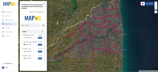
Conclusion Buffer zones and route analytics improve the precision of infrastructure projects. When used effectively, GIS supports proactive planning, better transport access, and reduced development risks across urban and rural areas.
#InfrastructureMapping#RoadNetworkPlanning#UrbanMobility#GISinInfrastructure#GeospatialTech#SmartCities#SmartMapping#DataDrivenPlanning#TransportationInnovation
1 note
·
View note