#Magnetometer survey
Explore tagged Tumblr posts
Visit Tumblr Blog
Explore Tumblr blogs with no restrictions, modern design and the best experience.
Last Seen Tumblr Blogs


Fun Fact
Tumblr’s reach among the 26-to-35-year-olds in the US is 11%.
Text
#marine survey#bathymetric survey#Hydrographic Survey#ADCP Survey#CTD Survey#Magnetometer survey#Sub Bottom Profiler Survey#Wave measurements#underwater photography#Marine Electric Cable Survey#marine pipeline survey#Backscatter Survey#Offshore pipeline route survey#Sediment sampling survey#situ testing#Near shore reflection seismic survey#Marine Geophysical Survey#MARINE ENVIRONMENTAL SURVEY#Marine Dredging Survey#Side Scan Sonar Survey#Oceanographic Survey#Environmental Baseline Studies#Marine Meteorological Survey
0 notes
Text

Explore Geometrics magnetometers, revolutionizing magnetic field measurement and navigation with unparalleled precision and cutting-edge technology at Dynatech Innovations.
0 notes
Text

Magnetometer Geophysical Survey
Every kind of mineral exhibits a unique magnetic susceptibility. This means different geological units below the ground can cause local disturbances within the magnetic field. For more, please see the website https://www.cxsltd.com/services/geophysics/magnetometer/
0 notes
Text
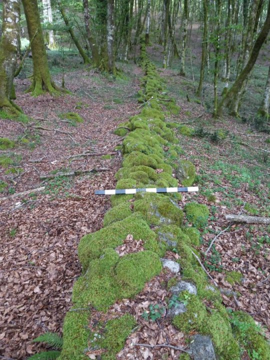
Ancient Roman Wall Used to Trap Spartacus Found in Italy
A team of archaeologists has found the remains of a Roman-constructed wall in Calabria, southern Italy. It was built with the purpose of trapping Spartacus, the former Roman gladiator who escaped and led a slave revolt.
The researchers behind this find, led by Dr. Paolo Visona, a classical archaeologist from the University of Kentucky in the United States, found the structure in the mountainous region of Calabria, where Spartacus and his men fled in 71 BC in order to escape Sicily.
Walls such as this one were constructed under the orders of the Roman general Marcus Licinius Crassus, who was in charge of the Roman legions. Crassus’ mission was to capture or murder Spartacus and his band of freed slaves and former gladiators.

Roman wall trapped Spartacus, a slave leader
The ancient wall dissects an area of the Dossone della Melia forest in the Calabria region right on the southern tip of Italy. The excavated stone wall and supporting earthwork was roughly 1.7 miles long and is mostly in good condition.
Archaeologists also uncovered a Roman defensive ditch known as a fossa as well as the remains of what seemed to have been an embankment system.
“The wall has now been conclusively identified as part of the structures built by the Roman general Marcus Licinius Crassus to contain the slave revolt leader Spartacus and his forces,” the Archaeological Institute of America said in a statement announcing the discovery.
Mostly covered by vegetation with only small sections visible to the eye, the remains of the Roman wall were not prominently on display. However, a group of environmental workers came across parts of the stone wall while hiking through the forest, and believing it to be something ancient, they notified local cultural authorities.
Researchers and archaeologists analyzed the structure after some time. They used ground-penetrating radar and LiDAR aerial survey equipment to find out more about the semi-buried wall’s construction. They also extracted soil samples and took magnetometer readings in an effort to learn more about when the wall was built.
Historical accounts of Spartacus’ life come primarily from Plutarch and Appian, who both penned their works more than a hundred years after his death. Plutarch’s Life of Crassus and Appian’s Civil Wars provide the most thorough account of the slave revolt.
Although he was a major character in Roman history, no contemporary sources exist, and all accounts were written by people who were only indirectly involved. There have been no testimonies from the slaves of eyewitnesses.
Very little is known about Spartacus besides the events of the war, and extant accounts are full of contradictions.
By Matthew Norman.


#Ancient Roman Wall Used to Trap Spartacus Found in Italy#Calabria Italy#Dossone della Melia forest#Spartacus#Roman general Marcus Licinius Crassus#Roman defensive ditch known as a foss#ancient artifacts#archeology#archeolgst#history#history news#ancient history#ancient culture#ancient civilizations#roman history#roman empire
158 notes
·
View notes
Text
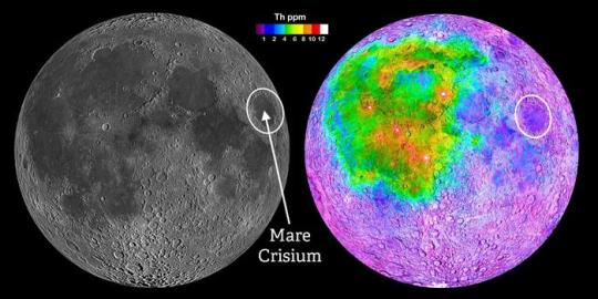
SwRI is sending its first instrument to the lunar surface to survey the Moon’s interior
LMS instrument aboard the Blue Ghost Lander heading to Mare Crisium in early 2025
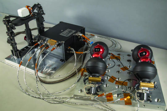
Through NASA’s Commercial Lunar Payload Services (CLPS) initiative, Southwest Research Institute developed the Lunar Magnetotelluric Sounder (LMS) to characterize the structure and composition of the Moon’s mantle by measuring electric and magnetic fields. The LMS instrument — manifested on the Blue Ghost lunar lander developed by Firefly Aerospace and targeted to launch on January 15, 2025 — will be the first SwRI instrument to touch the lunar surface. “For more than 50 years, scientists have used magnetotellurics on Earth for a wide variety of purposes, including to find oil, water, geothermal and mineral resources as well as to understand geologic processes such as the growth of continents,” said SwRI’s Dr. Robert Grimm, principal investigator of LMS. “The LMS instrument will be the first extraterrestrial application of magnetotellurics. NASA’s Artemis program is developing a series of increasingly complex missions to ultimately build a sustained human presence at the Moon for decades to come. To support these goals, LMS is part of a 14-day lunar lander mission to help understand the Moon’s subsurface in a previously unexplored location. Mare Crisium is an ancient, 350-mile-diameter impact basin that subsequently filled with lava, creating a dark spot visible to the naked eye on the Moon. Early astronomers who dubbed dark spots on the moon “maria,” Latin for seas, mistook them for actual seas. Mare Crisium stands apart from the large, connected areas of dark lava to the west where most of the Apollo missions landed. These vast, linked lava plains are now thought to be compositionally and structurally anomalous with respect to the rest of the Moon. From this separate vantage point, LMS may provide the first geophysical measurements representative of most of the Moon. Magnetotellurics uses natural variations in surface electric and magnetic fields to calculate how easily electricity flows in subsurface materials, which can reveal their composition and structure. LMS will allow scientists to probe the interior of the Moon to depths up to 700 miles or two-thirds of the lunar radius. The measurements will shed light on the material differentiation and thermal history of our Moon, a cornerstone to understanding the evolution of solid worlds. The LMS instrument ejects cables with electrodes at 90-degree angles to each other and distances up to 60 feet. The instrument measures voltages across opposite pairs of electrodes, much like the probes of a conventional voltmeter. The magnetometer is deployed via an extendable mast to reduce interference from the lander. The method reveals a vertical profile of the electrical conductivity, providing insight into the temperature and composition of the penetrated materials in the lunar interior. “The five individual subsystems of LMS, together with connecting cables, weigh about 14 pounds and consume about 11 watts of power,” Grimm said. “While stowed, each electrode is surrounded by a ‘yarn ball’ of cable, so the assembly is roughly spherical and the size of a softball.” The LMS payload was funded for delivery to the lunar surface through NASA’s CLPS initiative. SwRI designed the instrument, built the electronics box and leads the science investigation. Goddard Space Flight Center provided the LMS magnetometer to measure the magnetic fields, and Heliospace Corp. provided the magnetometer mast and four electrodes used to measure the electrical fields. Under the CLPS model, NASA is investing in commercial delivery services to the Moon to enable industry growth and support long-term lunar exploration. As a primary customer for CLPS deliveries, NASA aims to be one of many customers on future flights. NASA’s Marshall Space Flight Center in Huntsville, Alabama, manages the development of seven of the 10 CLPS payloads carried on Firefly’s Blue Ghost lunar lander.
TOP IMAGE: From within the Mare Crisium impact basin, the SwRI-led Lunar Magnetotelluric Sounder (LMS) may provide the first geophysical measurements representative of the bulk of the Moon. Most of the Apollo missions landed in the region of linked maria to the west (left image), whose crust was later shown to be compositionally distinct (right image) as exemplified by the concentration of the element thorium. Mare Crisium provides a smooth landing site on the near side of the Moon outside of this anomalous region. Credit NASA
LOWER IMAGE: LMSwRI led the development of the LMS instrument for the Mare Crisium lander mission, which includes (from left) a magnetometer, a central electronics box and four spring-launched electrodes. Credit Southwest Research Institute
7 notes
·
View notes
Text
A Geologist’s Nightmare: Slow Traditional Magnetometers? How JPMG’s 3‑Second Sampling Breaks the Deadlock
1. Introduction: The Speed Bottleneck That Haunts Geoscientists
In modern geological exploration, sampling speed often dictates project cost and feasibility. Traditional Proton Magnetometer and High‑Sensitivity Magnetometer units typically require 10–30 seconds per reading, severely hampering survey line efficiency. When faced with thick overburdens, subtle mineralization targets, and urban electromagnetic noise, geoscientists struggle to obtain reliable data in time, driving costs sky-high and creating safety risks.
2. Limitations of Conventional Magnetometers
Low Sampling Rate: Most legacy devices operate below 1 Hz, insufficient for real‑time profile mapping.
Poor Interference Rejection: Standard OCXO Magnetometer modules lack robust temperature drift compensation, leading to data distortion in varying climates.
Bulky Form Factor: Heavy Geomagnetic Survey Equipment demands extensive logistics support, limiting field agility.
Delayed Data Workflow: Wired data transfer hampers integration with Portable Magnetic Gradiometer and Underground Pipeline Detector systems, delaying analysis.
3. JPMG Series Proton Magnetometer: Cracking the 3‑Second Challenge
3.1 Core Sampling Technology
The JPMG Series combines an OCXO temperature‑controlled oscillator with an intelligent digital filtering algorithm, slashing single‑point sampling time to just 3 seconds while maintaining ±0.1 nT accuracy and enabling up to 0.33 Hz output.
3.2 Enhanced Sensitivity
Equipped with a High‑Sensitivity Magnetometer module, JPMG can resolve minute magnetic anomalies below 0.05 nT, delivering unmatched performance in subtle Magnetic Anomaly Detection.
3.3 Smart Data Integration
Seamless GPS/GIS, KML/CSV export, and real‑time telemetry make it trivial to synchronize with Portable Magnetic Gradiometer arrays or Underground Pipeline Detector networks, streamlining Mineral Exploration Tools and Archaeological Survey Equipment workflows.
4. Key Application Scenarios & Case Studies
Urban Pipeline Avoidance: Integrated with Underground Pipeline Detector systems, JPMG’s 3‑second cadence maps buried utilities in real time, safeguarding construction.
Hidden Mineral Target Delineation: In 30–50 m overburden settings, JPMG discriminates ore body boundaries that confounded traditional survey gear.
Archaeological Prospecting: As a part of Archaeological Survey Equipment, JPMG’s grid‑scan approach reliably hones in on subsurface ruins and foundation lines.
5. Competitive Comparison
Feature / MetricJPMG Series Proton MagnetometerCompeting Proton MagnetometerPortable Magnetic GradiometerAccuracy±0.1 nT±0.2 nT±0.5 nTSampling Time3 seconds10–15 seconds5 secondsInterference RejectionOCXO + digital filteringStandard oscillatorAnalog filteringData InterfacesGPS/GIS/KML/CSVCSV onlyProprietary formatPortabilityCompact handheldSplit‑bodyHandheld
6. Why Choose JPMG?
Efficiency: Reduces field survey time by over 30% with rapid 3‑second sampling.
Precision: ±0.1 nT accuracy and ultra‑high sensitivity catch even the faintest anomalies.
Portability: All‑in‑one handheld design thrives in rugged terrain where bulky gear falters.
Intelligence: Real‑time data upload complements any suite of Geological Prospecting Instruments, from Mineral Exploration Tools to Archaeological Survey Equipment.
7. Conclusion & Future Outlook
By fusing 3‑second sampling with high sensitivity and smart integration, the JPMG Series Proton Magnetometer redefines efficiency and accuracy across mineral exploration, urban survey, and archaeological applications. Looking ahead, as AI‑driven interpretation, UAV‑borne Magnetic Survey Equipment, and multi‑sensor fusion continue to evolve, JPMG is poised to anchor the next generation of portable Gradiometry and Geomagnetic Survey Equipment—ushering geological exploration into a new era of “real‑time data, intelligent insights.”
Tags
0 notes
Text
Virtual Reality Tracking and budget Motion Capture Research
Information required before reading. SteamVR: The main piece of software all VR users on a PC use, developed by Valve and free to own and use, it supports OpenXR runtime, which is an open standard almost all VR headsets use to unify them underneath one standard. SteamVR base stations (commonly known as just base stations): These are external units setup around a room for VR tracking, they use laser tracking technology developed by Valve and HTC in collaboration. Base stations are known as the golden standard of VR tracking, but come with a hefty price to use, often known for the top VR headsets and tracking methods using base stations.

The inside of a 1.0 Base Station - Source Inertial Measurement Unit (IMU): An IMU is a small chip that measures and reports it's force, angular rate, and sometimes the orientation of the body, using a combination of accelerometers, gyroscopes, and sometimes magnetometers. In layman's terms, this means they measure movement around a space, although they can be prone to drifting.
Full Body Tracking (FBT): This is a term used in VR to signify the legs and hip of a user being tracked, as well as the hands and head from the controllers and headset. While technically not "full body", this provides a much more immersive experience, with inverse kinematics (in layman's terms, your bodyparts on your VR character moving the way you'd expect them to in real life) to fill in the gaps.
Rokoko Smartsuit Pro II
The Rokoko Smartsuit Pro II uses the same technology in SlimeVR, IMUs, It uses 19 arranged around the suit. For the price of $2,245 (USD) Rokoko isn't cheap, but compared to the mocap industry which uses equipment which easily costs over 4x as much, Rokoko's Smartsuit comes in at a steal. They specifically target indie developers for this reason, as the Smartsuit doesn't require anywhere near the large setup of at least a 5m x 5m room that most commercial motion capture setups need. Although the Smartsuit sounds like a steal for the price, it still comes with the caveats of IMU based tracking, mainly drift and latency, which although less noticeable is still a downside compared to higher end motion capture systems. Rokoko's biggest downside is requiring a subscription for anything above just recording motion capture data, forcing users to pay at least $20 (USD) for any sort of streaming to in-engine,.
A Rokoko Smartsuit Animation capture video.
youtube
Vive & Tundra Trackers
The Vive trackers are HTC's approach to putting external trackers into Virtual Reality, these can be used on the body or on external controllers, such as a racket prop for tennis.
The benefits of Vive trackers is their laser tracking, using external SteamVR base stations, although this ends up being a negative too, as they are required for any kind of tracking. This is beneficial for people who are already in the SteamVR ecosystem, with VR headsets such as the Vive trackers. According to the steam hardware survey this is ~18% of all VR users on steam, which leaves a very wide margin of players who can not afford the bare minimum cost of entry, which is £140 for one SteamVR 2.0 base station, although two is recommended at minimum. Vive 3.0 trackers are also £140 each, this means for a user without existing base stations, the cost for an adequate full body tracking solution in VR runs them £700 (2x base stations and 3x Vive 3.0 trackers). This is an exorbitant amount considering that most people got their VR headsets for under £500, with the most popular being the Oculus Quest 2 for £300 at the time when it existed.
The Tundra trackers are a competitor to the Vive trackers, although they suffer the same core issues with needing , they are only £103 with a longer battery life and smaller size, making them a viable competitor, but still not a budget option for those without basestations.
A comparison image between a Vive 2.0 tracker, Vive 3.0 tracker and a Tundra Tracker

Xbox Kinect Tracking / Amethyst
For a cheap alternative to webcam tracking, that works better, the K2VR Team made a program called Amethyst, allowing use of a Xbox 360 or Xbox One Kinect to be used. This has it's benefits and drawbacks, with total cost ranging around £20, as an Xbox 360 Kinect is recommended, and can be bought for cheap 2nd hand, along with a 3rd party adapter for PC for not much more. The tracking quality of Amethyst is fairly good, although the other downsides make it much harder to achieve perfect tracking. The largest downside of Kinect tracking is that users must be looking in the direction of the Xbox Kinect at all times for good tracking, which is an incredibly large downside as in VR games, players tend to spin around in their physical reality playspace. Kinect isn't really recommended to do anymore, but is an option for those who want full body tracking in VR for incredibly cheap. Example video (Source)
Camera Tracking
Mediapipe / AprilTags:
For VR tracking there are many open source tools to use a webcam to transmit skeleton data to SteamVR, for this I'll be looking into MediapipeVR and AprilTags, both developed by github user Ju1ce. AprilTag is a tool that uses a webcam with apriltag markers, making a skeleton from these markers to transmit the data into SteamVR. Mediapipe is a fork of this, using just the person in the frame as a way to track by building a skeleton over them. This is how many of the other forms of webcam FBT do their tracking. It's a free solution but comes with the same downsides as Kinect tracking, along with a big accuracy hit, as a webcam doesn't use the same kind of advanced sensors a Kinect does.
A picture of AprilTag tracking (Source)

Rokoko Vision:
Rokoko Vision is a free to download piece of software by Rokoko, it's used as a motion capture solution for indie developers, and those who cant not afford the several thousand pound minimum for a mocap tracking solution. As a freemium product, Rokoko is well reviewed, being called a "game changer for quick prototyping or indie projects". It's barrier to entry being just a phone or camera makes it incredibly low cost, allowing anyone to record up to 15 seconds of footage for free, and up to 2 minutes when paying. Environmentally though, Rokoko Vision becomes a problem, as they use AI to fill in all of the gaps, which takes a fair amount of computing power, and it's easy to wonder if it's worth the extreme amount of computing power that AI takes to deliver an experience that is still subpar compared to cheap motion capture.
HaritoraX

HaritoraX is another IMU based solution, being made by Shiftall Inc, who make a wide variety of different VR accessories and even a headset. Their Full Body Tracking solution, HaritoraX 2, uses a mix of 6 IMUs to achieve full leg and upper body tracking, along with LiDAR sensors in the lower legs to detect ankle motion, although this is an optional choice to save battery life.

The main drawback of HaritoraX is it requires a dongle or bluetooth on a computer, which is both laggy on occasion, and can produce some latency from movement to in-game response. Along with sub-par tracking, due to using Shiftall's own software. Although users have begun routing their trackers through SlimeVR to get it's more optimal AutoBone and Skeleton technology. Boasting a £259 price point, HaritoraX 2 is far cheaper than almost any other fullbody tracking solution out there, making it a good solution for those on a budget or without SteamVR base stations.
Source for pictures: Shiftall Product page
Conclusion: My trackers will be focused on the ~77% of VR users who do not use SteamVR laser tracked headsets, as the barrier for entry is leagues higher for these people, as they have a £700 minimum cost for reasonable tracking. With a focus on lasting long with changeable batteries that are cheap, I hope to make my trackers able to outlast the next generation of headsets, for a continued low cost.
Why Virtual Reality Motion Tracking?
The most popular use of VR motion tracking is for full body tracking, namely in use of the game VRChat, which is VR's biggest social platform. Other games, such as Blade and Sorcery, use it to put a player's legs in the game to enable kicking and using the legs as a physical object, enhancing immersion and player enjoyment.
Other games support Motion Tracking to add physical guns into VR, namely Arizona Sunshine or Duck Season.
youtube
youtube
1 note
·
View note
Text
Phantom Indians of the Swamp
Some things that we witness under weird circumstances force to examine our assumptions about the very nature of time and space. What we have come to call Phantom Indians, reported from the strangeness that is the Trinity River swamp, certainly fit that category.
It is known that strong magnetic anomalies can produce a bleed-over effect in radio reception in a given area. We've all run into while driving long distances. The frequency band may temporarily bleed over into another, or a radio receiver may also pick up signals from far beyond its normal range. When strong anomalies occur, they could theoretically produce little-understood conditions, during which, as bizarre as it may sound, aspects of a reality or dimension at one frequency could temporarily bleed into another.
If this can be said about dimensions of space, what can be said about how such weird energy conditions could affect the dimension of time? There is a theory of modern physics involving what are called time lines. According to this theory, this past does not simply disappear, but remains on a time-line other than the one we are consciously experiencing. It is within the terms of such a theory, in which time-line bleeds occur corresponding to radio-frequency bleeds, that we can begin to account for the patterns suggested by the Phantom Indian stories below. They seem to tell of manifestations of beings as much from another time as another dimension. Interestingly, the stories come from several independent sources, and the teller of one tale was unaware of the experiences of another.
Let's start with Rick, a professional treasure hunter from the Texas Gulf Coast. Rick has spent years exploring the Gulf of America (formerly Gulf of Mexico*) and the Caribbean and has been successful in finding lost Spanish gold. He flies over an area in an airplane equipped with a magnetometer-a device resembling an oversized metal detector-that picks up anomalies in the magnetic field. Large deposits of metal such as would be contained in a buried treasure, can cause such anomalies. This technique works especially well in such swampy areas as those of the Texas Gulf Coast, which contain little or no natural metal-bearing stone.
One day, as he was surveying a section of the lower Trinity Swamp just off Trinity Bay, he came across a spot with just such a magnetic anomaly. Rick knew that this particular stretch of the bay was the subject of legends about pirate Jean Lafitte's buried treasure, so he was encouraged by the magnetometer's readings. He excitedly set out to explore the site on foot, but when he approached the area, he met a game warden. The warden, a little suspicious of Rick because he wasn't carrying hunting or fishing equipment, asked him where he was going. When Rick told him, the warden surprised Rick by advising him not to proceed.
The game warden said that a number of hunters and fishermen had reportedly been attacked by strange people in the area Rick wanted to investigate. The warden believed the reports because he had also been accosted. Naturally, Rick asked who would be hostile enough to attack innocent sportsmen and a park official. The warden looked at Rick as if trying to decide whether Rick would think he was nuts if he told the truth. Rick must have looked okay, because the warden told him that an "Indian" had attacked him and barely missed hitting him with an arrow. At least he through the dark and practically naked figure who had assaulted him was an Indian. It could possibly be anyone else.
Rick couldn't help but wonder what kind of weirdo would be wandering the swamp apparently playing a serious game of cowboys and Indians. The game warden claimed that he had retrieved the arrow that had been shot at him and that he had examined it closely. It appeared to be handmade, with a rough and primitive appearance. The Indian was also quite strange-looking, the warden said, and seemed so primitive that it was as if he were from another time.
At the time, Rick merely thought the incident to be curious, but he believed the story enough to heed the game warden's advice and not enter the swamp on foot. There's no way to know whether the arrow in question even existed, but there is an element to the story that prevents us from dismissing it as hearsay. What had attracted Rick to that particular spot in the swamp was a strong localized magnetic anomaly, the kind that theoretically could be associated with a time-line bleed.
Rick's experience is not an isolated one. A possibly corroborating incident comes from the mother of a Beaumont man named Eddie. Eddie's mom had a cabin in a fishing camp near the lower Trinity River near Trinity Bay, the same area where Rick's treasure-hunting experience occurred. An old man who ran a small store and bait shop there had told her the following story.
A lineman had been sent to make repairs to an electric utility line in a remote area on the margins of the swamp. When he finished making the repairs, he looked down and was startled to find that he was surrounded by what he described as several "Indians" who had gathered around the base of the pole. After they had stared at him threateningly for a few minutes, they disappeared into the surrounding woods. The lineman said they were practically named and remarkably primitive in appearance. Why the supposed Indians hadn't shot the astonished lineman is anyone's guess.
Yet again, elements in this story suggest the same patterns we have seen. Could it be that the lineman was sent to make repairs because there was a localized power outage caused by an intense local magnetic anomaly that had attracted Rick to the area in search of buried treasure?
The old man at the bait shop tried to investigate the region after he had heard the lineman's story, but he was quickly discourage by a horrifying discovery: He found what was left of a human skeleton strapped to the base of a tree not far from the pole where the lineman said he had seen the Indians.
There actually had been a tribe of particularly primitive Indians on the Texas Gulf Coast that had roamed the area where both these events took place. They were known to perform a brutal ritual on their captured enemy: They strapped the unfortunate victim to a tree and stripped pieces of flesh from the body. They then roasted the flesh in a bonfire before the captive's eyes and frenziedly danced around the fire in a drugged stupor induced by drinking intoxicant made form fermented yaupon berries. That tribe was the Karankawa.
The Karankawa-Brutal but Stinky
Tom, a Houston businessman and amateur treasure hunter, provided yet another story about what could be sightings of the Karankawa on the Texas coast. Tom was beachcombing near the mouth of Trinity Bay with his metal detector, when he had a chance meeting with a treasure hunter he knew from the previous outings. Tom Told him that he would like to take an airboat into the bayous that empty into the Trinity River to look for the legendary treasure of the Jean Lafitte.
The treasure hunter advised Tom against it, because he knew people who had been attacked by Indians in the bayous at the upper end of the bay. Tom asked why the people thought they had been attacked by Indians and not by, say, a bunch of gung-ho, drug-crazed survivalists. Because the attackers had used bows and arrows, the man said, and because the arrows used the Indians themselves were very primitive-looking.
There was also the stench. The attackers reeked so badly, apparently from smearing themselves with putrefied animal fat, that they could be smelled from some distance. Tom knew enough about the Karankawa to know that they were said to have covered themselves in alligator or shark grease for protection against the clouds of mosquitoes infesting the swamps and that they were known for their horrible smell. Tom told us his story before he heard the two other accounts of the Karankawa possibly being seen near Trinity Bay.
So what are we to make of all this? Could there possibly be surviving band of primitive Indians patrolling their ancient swampland and coastal territories? According to historians and archaeologists, the Karankawa vanished almost two hundred years ago, leaving virtually no trace of their existence.
When we at Weird Texas first hand these tales, we thought that the Indians were perhaps ghosts or phantoms. But could mere specters fire solidly real arrows at those unwittingly violate their boundaries? In an area known for a range of bizarre phenomena associated with anomalous magnetic episodes, we have to at least consider that sometimes elements of the past can bleed into the present. For the sake of anyone venturing into the primordial wilds of the Trinity River swamp, we hope that the process does not work both ways.
0 notes
Text
Reliable Geophysical Tools for Accurate Site Surveys

Unique Group offers a wide variety of geophysical survey equipment for different projects, including marine construction, site surveys, and search operations. These high-quality products support industries like renewables, oil and gas, and marine. With options available for both rental and purchase, Unique Group ensures timely access to tools such as sonar systems and magnetometer systems. Their solutions are designed for both efficiency and reliability, backed by expert advice and support. Unique Group's geophysical equipment assists in the completion of complex offshore and subsea operations, providing essential data and insights.
0 notes
Text
AI and Historical Maps Unite to Locate Abandoned Oil Wells

Source: newscenter.lbl.gov
Category: News
The Hidden Legacy of Abandoned Wells
AI and Historical Maps are proving to be a game-changer in identifying and addressing the environmental hazards posed by undocumented orphaned wells (UOWs). The United States is grappling with the environmental consequences of its long history of oil and gas extraction, particularly in the form of undocumented orphaned wells (UOWs). These abandoned wells, many of which have been left without a responsible operator or official documentation, pose significant threats to both the environment and public health. From methane emissions that accelerate climate change to the contamination of water supplies with toxic substances, the dangers are clear. Yet, pinpointing the locations of these hidden relics, estimated to number between 310,000 and 800,000, has long been a daunting challenge.
Combining AI and Historical Maps to Find UOWs
Recent advancements in artificial intelligence (AI) have provided a promising solution to the problem of locating orphaned wells. In a groundbreaking project, researchers have turned to historical maps, some dating back as far as 1884, to help identify the sites of former oil and gas operations. These topographic maps, digitized by the U.S. Geological Survey (USGS), offer valuable insights into early drilling activities. The challenge, however, is sorting through vast archives of these old maps.
Fabio Ciulla, a postdoctoral fellow at the Lawrence Berkeley National Laboratory, has been instrumental in leveraging AI to analyze these maps. By using a U-Net convolutional neural network, an AI algorithm designed to recognize oil well symbols, researchers can now identify potential UOW locations with remarkable accuracy. The system was trained on manually labeled maps and applied to regions with significant oil production histories, such as Kern and Los Angeles counties in California, and Osage and Oklahoma counties in Oklahoma. In these areas, the AI identified over 1,300 potential orphaned wells.
Verifying AI Findings and Expanding Detection Efforts
While AI has proven effective in identifying potential well sites, verification remains a critical step. Researchers use satellite images and historical aerial photos to search for visual signs of abandoned wells, such as pump jacks or storage tanks. In cases where surface evidence is lacking, magnetometers are deployed to detect buried metal well casings. The accuracy of the AI is impressive, with wells being located within an average of 10 meters of their predicted positions.
AI and Historical Maps represent a significant leap over traditional approaches, such as manual record searches or on-the-ground surveys, which are often slow and geographically limited. However, the project doesn’t stop at map analysis. As part of the Consortium Advancing Technology for Assessment of Lost Oil & Gas Wells (CATALOG), the effort includes a range of advanced tools, such as drones equipped with methane sensors and magnetometers, to detect leaks and locate buried wells. Additionally, researchers are working on cost-effective solutions to monitor methane emissions, an essential step in mitigating the environmental impact of orphaned wells.
The CATALOG initiative is also tapping into citizen science, encouraging individuals to use smartphone magnetometers to help locate abandoned wells. This crowdsourced approach expands the reach of detection technologies, providing valuable data while complementing professional surveys.
A Cleaner Future Through Collaboration and Innovation
The AI and Historical Maps-driven efforts spearheaded by CATALOG offer a glimmer of hope in addressing the legacy of America’s oil boom. By integrating historical data with modern technology, the project not only improves the accuracy of orphaned well detection but also lays the groundwork for more effective remediation. Collaboration with local communities, including Native American tribes and environmental agencies, is crucial to the initiative’s success. As researchers continue to refine their techniques, they are not only tackling the immediate environmental risks posed by orphaned wells but also contributing to broader climate mitigation efforts.
As Sebastien Biraud, a scientist at Berkeley Lab, notes, finding solutions to limit emissions is essential for the future. By combining AI, cutting-edge sensors, and community involvement, researchers are uncovering a hidden legacy of the nation’s energy history while paving the way for a cleaner and safer future.
0 notes
Text
The Importance of Magnetic Surveys in Delhi's Geophysical Applications
As Delhi continues to grow and develop, the need for precise geophysical analysis becomes increasingly important. One of the most effective methods used in this field is the magnetic survey in Delhi. This technique provides valuable insights into the subsurface conditions, helping engineers, urban planners, and environmentalists make informed decisions. In this blog, we will explore the various application areas of magnetic surveys and their significance in Delhi's development landscape.
What is a Magnetic Survey?
A magnetic survey is a geophysical technique that measures variations in the Earth’s magnetic field. By utilizing sensitive instruments called magnetometers, geophysicists can detect and analyze magnetic anomalies caused by different subsurface materials. This data is crucial for understanding the geological structure of an area and is widely used in various applications.
Applications of Magnetic Surveys
Infrastructure Development
In a rapidly urbanizing environment like Delhi, infrastructure development is vital. The magnetic survey in Delhi plays a crucial role in assessing ground conditions before construction projects begin. By identifying buried structures, voids, and geological features, engineers can design safer foundations. This method minimizes the risk of unexpected issues during construction, leading to more efficient project execution.
Mineral Exploration
Delhi's surrounding regions hold various mineral resources. Magnetic surveys are essential for locating and mapping these deposits. By analyzing magnetic data, geologists can identify areas rich in minerals, guiding exploration efforts. This application is particularly important for industries involved in mining and resource extraction, as it helps reduce costs and improve efficiency.
Archaeological Investigations
Delhi has a rich historical heritage, and archaeological sites often lie beneath the surface. Magnetic survey in Delhi is used to locate and map these hidden sites without intrusive digging. By detecting anomalies caused by buried structures, archaeologists can pinpoint areas of interest and plan their excavations more effectively. This non-invasive approach preserves the integrity of historical sites while providing valuable information.
Environmental Studies
Environmental assessments are crucial for sustainable development. Magnetic surveys help identify contamination sources and assess soil stability. In Delhi, where urban pollution is a concern, these surveys can detect buried waste and help in planning remediation efforts. Understanding subsurface conditions is essential for ensuring that construction projects do not adversely impact the environment.
Groundwater Studies
Access to clean groundwater is vital for any urban area. Magnetic survey in Delhi can aid in identifying aquifers and understanding groundwater flow patterns. By analyzing magnetic data, hydrogeologists can assess the feasibility of groundwater extraction and develop sustainable management plans. This is especially important in regions facing water scarcity.
Geotechnical Investigations
Before any construction project, thorough geotechnical investigations are necessary. Magnetic surveys provide critical information about the subsurface geology, including soil types and their properties. This data helps engineers design appropriate foundations and assess potential risks, such as landslides or soil erosion. In a city like Delhi, where construction is constant, these investigations are essential for ensuring safety.
Benefits of Using Magnetic Surveys
Non-Invasive Methodology
One of the significant advantages of magnetic surveys is their non-invasive nature. Unlike traditional excavation methods, magnetic surveys do not disturb the ground, preserving the integrity of the site. This is particularly beneficial in urban areas like Delhi, where disturbances can lead to traffic issues and affect nearby structures.
Cost-Effective Solutions
Magnetic survey in Delhi offers a cost-effective solution for subsurface analysis. By providing accurate data early in the project lifecycle, these surveys help prevent costly delays and unexpected expenses. This efficiency is crucial for developers and project managers who need to stay within budget and timelines.
High Resolution and Sensitivity
Modern magnetometers used in magnetic surveys are highly sensitive and capable of detecting even subtle magnetic anomalies. This high resolution ensures that critical features are not overlooked, providing a comprehensive understanding of the subsurface conditions.
Versatility
Magnetic surveys are versatile and can be applied in various fields, including construction, mining, archaeology, and environmental studies. This adaptability makes them a valuable tool for professionals in multiple industries.
Conclusion
As Delhi continues to expand, the importance of precise geophysical analysis cannot be overstated. The magnetic survey in Delhi offers a range of applications that are crucial for informed decision-making in construction, mineral exploration, archaeology, environmental studies, and groundwater management. By providing valuable insights into subsurface conditions, magnetic surveys help ensure that projects are executed safely and efficiently.
For urban planners, engineers, and environmentalists in Delhi, embracing the advantages of magnetic surveys can lead to more sustainable and successful projects. As the city grows, the need for innovative solutions to assess the earth beneath our feet will only increase, making magnetic surveys an essential component of modern geophysical practices. With the right technology and expertise, Delhi can continue to thrive while preserving its rich history and environment for future generations.
0 notes
Text
Global Fluxgate Magnetometer Market Situation and Forecasting Trends Analysis 2024 - 2031
The global fluxgate magnetometer market is witnessing steady growth, driven by the increasing demand for precise magnetic field measurement in various applications, including geophysical surveys, environmental monitoring, and defense. This article provides a comprehensive analysis of the market dynamics, key trends, competitive landscape, and future outlook for fluxgate magnetometers.

Introduction to Fluxgate Magnetometers
Fluxgate magnetometers are sensitive instruments designed to measure the strength and direction of magnetic fields. They operate on the principle of magnetic induction and are known for their high accuracy and stability. These devices are widely used in applications such as geological exploration, aerospace, and military operations, where precise magnetic measurements are essential.
The global fluxgate magnetometer market presents considerable opportunities driven by increasing demand for precise magnetic field measurements and the expansion of key industries.
Market Overview
Current Market Size and Growth
As of 2023, the global fluxgate magnetometer market is valued at approximately $XX million, with projections to reach $XX million by 2030, growing at a CAGR of XX% during the forecast period. This growth is attributed to the expanding applications of fluxgate magnetometers across various industries and advancements in technology.
Key Market Drivers
Increasing Demand for Geological Surveys: The mining and oil exploration industries are driving the demand for fluxgate magnetometers, as these instruments provide critical data for resource identification and evaluation.
Technological Advancements: Innovations in sensor technology and miniaturization are enhancing the performance and applicability of fluxgate magnetometers, making them more attractive to users.
Environmental Monitoring Needs: Growing concerns regarding environmental changes and the need for magnetic field monitoring in various ecosystems are contributing to market growth.
Challenges in the Market
Despite its growth potential, the fluxgate magnetometer market faces several challenges:
High Costs: The initial investment for high-quality fluxgate magnetometers can be significant, which may limit adoption among smaller enterprises and researchers.
Competition from Alternative Technologies: The presence of alternative magnetic measurement technologies, such as superconducting quantum interference devices (SQUIDs), can pose a competitive challenge to fluxgate magnetometers.
Types of Fluxgate Magnetometers
1. Single-Axis Fluxgate Magnetometers
Single-axis fluxgate magnetometers measure magnetic fields along one axis and are typically used in applications requiring basic magnetic measurements, such as environmental monitoring and educational purposes.
2. Three-Axis Fluxgate Magnetometers
Three-axis fluxgate magnetometers measure magnetic fields along three orthogonal axes, providing a comprehensive magnetic field profile. These are commonly used in geophysical surveys, aerospace applications, and military operations.
3. Portable Fluxgate Magnetometers
Portable fluxgate magnetometers are designed for field applications and are lightweight and easy to use. They are widely employed in geological surveys and environmental studies where mobility is essential.
Regional Analysis
North America
North America holds a significant share of the global fluxgate magnetometer market, driven by strong demand from the defense and aerospace sectors. The United States is the largest market, with ongoing investments in geophysical research and environmental monitoring.
Europe
Europe is witnessing steady growth in the fluxgate magnetometer market, supported by increasing research and development activities in geophysics and environmental sciences. Countries such as Germany, France, and the UK are key contributors to market expansion.
Asia-Pacific
The Asia-Pacific region is expected to experience significant growth, fueled by rapid industrialization and increasing investments in mining and resource exploration. Countries like China and Australia are driving demand for fluxgate magnetometers in various applications.
Latin America and Middle East & Africa
The market in Latin America and the Middle East & Africa is gradually developing, with growing awareness of the importance of geophysical studies and environmental monitoring. The expansion of mining and oil exploration activities in these regions is propelling demand for fluxgate magnetometers.
Competitive Landscape
Key Players
Honeywell International Inc.
Magnetometrie
Nikon Metrology, Inc.
Bartington Instruments Ltd.
Geometrics Inc.
These companies focus on product innovation, quality enhancements, and expanding their distribution networks to capture a larger market share.
Market Strategies
Research and Development: Companies are investing in R&D to enhance the performance and capabilities of fluxgate magnetometers, making them suitable for a broader range of applications.
Strategic Partnerships: Collaborations with academic institutions and research organizations help manufacturers understand market needs and develop tailored solutions.
Future Outlook
The global fluxgate magnetometer market is poised for substantial growth in the coming years. As industries continue to prioritize accurate magnetic measurements for various applications, the demand for fluxgate magnetometers is expected to rise. Additionally, advancements in technology will likely lead to the development of more sophisticated and versatile instruments.
Conclusion
The global fluxgate magnetometer market presents considerable opportunities driven by increasing demand for precise magnetic field measurements and the expansion of key industries. While challenges such as high costs and competition from alternative technologies exist, the overall outlook remains positive. Stakeholders in the industry should focus on innovation and customer engagement to thrive in this dynamic market.
#Global Fluxgate Magnetometer Market Size#Global Fluxgate Magnetometer Market Trend#Global Fluxgate Magnetometer Market Growth
0 notes
Text
Revolutionizing Industries with Magnetometers
Magnetometers are instruments that measure magnetic fields and are transforming many industries with their precision and versatility. They come in different types, like scalar and vector magnetometers, and are used in various applications, such as geological surveys, mineral exploration, space research, and navigation. Their ability to provide precise magnetic measurements makes them invaluable in both scientific research and practical uses.
Explore the precision of magnetic field measurement with our advanced magnetometers at Dynatech Innovations.
0 notes
Text

Magnetometer Geophysical Survey
Every kind of mineral exhibits a unique magnetic susceptibility. This means different geological units below the ground can cause local disturbances within the magnetic field. For more, please see the website https://www.cxsltd.com/services/geophysics/magnetometer/
0 notes
Text
0 notes
Text
In-Depth Analysis of the JPMG Series Proton Magnetometer
I. Introduction
II. Definition and Concept
2.1 Overview of the Proton Magnetometer
The Proton Magnetometer operates based on the proton magnetic resonance principle, wherein the precession frequency of protons in a magnetic field is directly proportional to the magnetic field strength. By accurately measuring this precession, the instrument provides exceptionally precise magnetic data—making it a cornerstone for Proton Magnetometer applications in detecting magnetic anomalies and surveying geologic structures.
2.2 The Role of OCXO Technology
The incorporation of the Oven Controlled Crystal Oscillator (OCXO) in the JPMG series ensures ultra-stable frequency output under varying environmental conditions, minimizing temperature drift and providing high data accuracy. This technological innovation positions the JPMG as an industry-leading OCXO Magnetometer suitable for high-precision measurements.
2.3 Key Terminology Explained
To better understand the product’s market position, consider the following definitions:
Proton Magnetometer: An instrument that measures Earth’s magnetic field based on proton resonance.
High-Sensitivity Magnetometer: Capable of capturing minute variations in magnetic fields, vital for detecting subtle anomalies.
Geomagnetic Survey Equipment: Devices used for wide-ranging surveys of Earth’s magnetic field to infer subsurface structures.
Portable Magnetic Gradiometer: A compact device designed for field surveys with high mobility, crucial in challenging environments.
Mineral Exploration Tools: Equipment utilized to locate and evaluate potential mineral deposits.
Archaeological Survey Equipment: Instruments aiding in the non-invasive detection of subsurface cultural and historical artifacts.
Underground Pipeline Detector: Tools designed for accurately locating buried pipelines to avoid construction hazards.
Magnetic Anomaly Detection: The process of identifying local magnetic field variations that indicate hidden subsurface features.
Geological Prospecting Instruments: An umbrella term for devices used in detailed geological surveys and resource prospecting.
III. Comparative Analysis of Magnetic Survey Methods
3.1 Operational Principles
Different magnetometers, such as magnetic resistance sensors, Hall effect magnetometers, and optical-pumping magnetometers, operate on varying principles:
Proton Magnetometers (e.g., JPMG Series) use proton resonance, offering high accuracy and stability.
Magnetic Resistance Sensors are more cost-effective but sensitive to temperature variations and noise.
Optical Pumping Magnetometers offer high sensitivity but typically come with complex configurations and higher costs.
3.2 Performance Metrics
The JPMG Series excels in several performance areas:
Sensitivity and Accuracy: With an accuracy reaching 0.01 nT, it is among the most precise High-Sensitivity Magnetometers available.
Data Acquisition Rate: Supporting flexible sampling rates, the instrument captures real-time magnetic variations ideally suited for dynamic field environments.
Portability: Its lightweight design ensures quick deployment in field surveys, classifying it as a premier Portable Magnetic Gradiometer.
Stability: OCXO technology significantly enhances measurement stability, a notable advantage over conventional systems.
3.3 Forward and Inverse Modelling Comparison
For geophysical data processing, forward modelling uses geological models to predict magnetic anomalies, while inverse modelling deduces subsurface structures from measured data. With its superior data quality, the JPMG series enables more reliable inverse modelling, reducing error margins by approximately 20% compared to older systems. This improvement is critical for accurate Magnetic Anomaly Detection and enhances the interpretative value for Geological Prospecting Instruments.
IV. Application Scenarios and Case Studies
4.1 Mineral Exploration
In mineral exploration, the ability to detect subtle magnetic anomalies is essential for delineating ore body boundaries. Case Study: In a northern mining district, the JPMG Series was deployed over a 50-meter thick cover layer. The high-sensitivity measurements revealed a clear magnetic anomaly corresponding to an iron-rich zone. Subsequent drill tests confirmed the anomaly, demonstrating the instrument’s effectiveness as a reliable Mineral Exploration Tool.
4.2 Archaeological Surveys
Archaeologists often rely on non-invasive methods to identify underground structures without damaging precious artifacts. Case Study: At a heritage site in the arid regions, the JPMG Series was employed to scan for subsurface cultural remnants. The instrument successfully isolated distinct linear magnetic anomalies indicative of ancient building foundations. This result not only streamlined the excavation process but also preserved site integrity, proving its value as advanced Archaeological Survey Equipment.
4.3 Underground Pipeline Detection
Accurate mapping of underground pipelines is critical for urban infrastructure planning and maintenance. Case Study: During a municipal upgrade project, the JPMG Series was used to detect buried pipelines amid a complex urban environment. Its portable design and high resolution enabled the rapid identification of multiple pipeline networks, reducing potential construction hazards and ensuring project safety. This application underscores its role as an efficient Underground Pipeline Detector.
4.4 Environmental and Geological Hazard Assessment
Reliable magnetic data is also instrumental in evaluating urban geohazards and environmental pollution. Case Study: A coastal city deployed the JPMG Series as part of a disaster prevention program. The instrument’s data revealed subtle magnetic irregularities associated with potential fault zones and contamination sources. This enabled local authorities to implement pre-emptive risk mitigation strategies, demonstrating its utility in both Geomagnetic Survey Equipment and Geological Prospecting Instruments sectors.
V. Product Advantages and Competitive Edge
After extensive testing and side-by-side comparisons, the JPMG Series Proton Magnetometer stands out for several reasons:
Superior Sensitivity and Accuracy: Achieving measurements down to 0.01 nT, it outperforms many competitor instruments.
Robust OCXO Stabilization: The incorporation of OCXO technology ensures exceptional data fidelity even under temperature fluctuations.
Portability and Ease of Operation: Its ergonomic, lightweight design facilitates field deployment, reducing setup and operational complexities.
Integrated Data Processing: The high-performance onboard processor supports real-time data analysis and seamless integration with geospatial software.
Versatility Across Disciplines: Whether in mineral exploration, archaeological surveys, or underground infrastructure detection, the JPMG Series meets diverse operational needs.
VI. Future Trends and Market Outlook
The demand for advanced geophysical instruments continues to grow in response to increasing global resource exploration and environmental monitoring needs. Future trends include:
智能传感器集成:下一代磁力仪将进一步融入人工智能和物联网功能,实现预测分析和���程监控。
多方法协同:与电阻率层析成像(ERT)和感应极化(IP)等技术相结合, 将提供全面的地下成像,从而提高解释准确性。
经济高效的创新:随着地球物理设备市场竞争日益激烈,成本效益与高性能的结合将至关重要。JPMG系列凭借其极具竞争力的价格和久经考验的可靠性,占据了显著的市场份额。
VII. Conclusion
In conclusion, the newly launched JPMG Series Proton Magnetometer represents a breakthrough in geophysical survey technology. Its high sensitivity, portability, and robust data processing capabilities make it an indispensable tool for professionals in mineral exploration, archaeological surveying, underground pipeline detection, and broader geological prospecting. The comprehensive analysis presented here—from operational principles and method comparisons to real-world case studies—demonstrates that the JPMG Series not only meets but exceeds the stringent requirements of modern geophysical investigations.
For engineers, archaeologists, and geologists seeking an advanced High-Sensitivity Magnetometer and Portable Magnetic Gradiometer, the JPMG Series offers unmatched precision and reliability. As the market evolves, such instruments will become increasingly vital for accurate Magnetic Anomaly Detection and sustainable resource management. Embrace the future of geophysical exploration with the JPMG Series Proton Magnetometer—a true game changer in the industry.
0 notes