#Torchiara
Text
Tutto pronto per il Lunatic Book Festival
Tutto pronto per il Lunatic Book Festival
Martedì 14 giugno 2022, alle ore 18.00, si terrà presso il Palazzo Baronale De Conciliis a Torchiara, il Lunatic Book Festival. La notte della Superluna 2022. L’iniziativa è organizzata da L’Argolibro Editore con il Patrocinio del Comune di Torchiara. Una piacevole serata dedicata alle autrici e agli autori dell’Argolibro, che vedrà la partecipazione di vari musicisti, pittori e fotografi.…

View On WordPress
#carmen giardina#Casa Editrice l&039;Argolibro di Agropoli#cinema#cultura#L&039;Arte dell&039;Incontro. Interviste ai personaggi dello spettacolo#La notte della superluna#libri#Luisa Corna#lunatic book festival#maria cuono#maria cuono communication#musica#Palazzo Baronale De Conciliis#teatro#Torchiara
0 notes
Photo
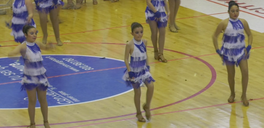
Torchiara, Campionati Nazionali di ballo Opesdanza
0 notes
Photo

Torchiara, iscriviti al Circolo Legambiente “Ancel Keys” Torchiara -Alto Cilento! Il Circolo Legambiente “Ancel Keys” Torchiara- Alto Cilento rinnova il suo invito al tesseramento 2019. Da Gennaio, infatti, è aperta la campagna per diventare soci di un Circolo che mette al centro delle sua attività il benessere del cittadino, combattendo insieme per un mondo che rispetti maggiormente il proprio ecosistema.
0 notes
Photo

presso Torchiara https://www.instagram.com/p/Bu1u90kHbhE/?igshid=148kfhtsw7063
1 note
·
View note
Photo
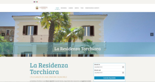
Casa Vacanze La Residenza Tochiara Torchiara Salerno distante solo 5 Km dal mare Immersa nel verde del Parco nazionale del Cilento e di Valle di Diano www.laresidenzatorchiara.it Casa Vacanze La Residenza Tochiara, Torchiara, Salerno. La Residenza Torchiara vanta una posizione ottimale per raggiungere agevolmente le splendide località del Cilento, distante solo 5 Km dal mare.
#Appartamenti Vacanze#Appartamenti Vacanze Campania#Appartamenti Vacanze Cilento#Appartamenti Vacanze Parco Nazionale del Cilento#Appartamenti Vacanze Torchiara#Appartamenti Vacanze Valle di Diano#Casa Vacanze#Casa Vacanze Campania#Casa Vacanze Cilento#Casa Vacanze Parco Nazionale del Cilento#Casa Vacanze Torchiara#Casa Vacanze Valle di Diano#Cilento#Parco Nazionale del Cilento.#Torchiara#Vacanze Cilento#Vacanze Parco Nazionale del Cilento#Vacanze Valle di Diano#Valle di Diano
0 notes
Text
Cilento Sport Festival, oltre mille presenze da tutt’Italia
Nello Malafronte, Sud Eventi: “La bellezza del Cilento dà un grande impulso ai nostri eventi”
Nello Malafronte, Sud Eventi: “La bellezza del Cilento dà un grande impulso ai nostri eventi”
(more…)
View On WordPress
0 notes
Text
Ottica Bisogno & Philipp Plein: quando la tendenza fa moda

Un evento glamour e fashion. Un evento riuscito, organizzato nel rispetto di tutte le norme di prevenzione anti-Covid 19, che ha sancito la collaborazione fattiva tra il gruppo Ottica Bisogno e il marchio Philipp Plein, tra gli stilisti più affermati sul panorama internazionale della moda negli ultimi anni. Gli occhiali della nuova linea griffati PP, potranno essere acquistati presso gli store Ottica Bisogno di Roccapiemonte, Baronissi, Torchiara e San Gregorio Magno. Un assaggino c’è stato al DaRì di Roccapiemonte, dove la famiglia Bisogno ha ospitato amici e curiosi, tra questi anche l’artista Giovanni Trapani, per tutti Trapanig, ed alla presenza degli inviati del nostro mensile e della troupe di Radio Base di Errico Marrazzo, con le simpatiche incursioni e le interviste di Luca Virno. Di questo evento abbiamo parlato con Niko Bisogno che, sulle orme di papà Massimo, sta cercando di mettere in piedi appuntamenti sempre particolari e che puntano a lasciare il segno. «Distinguerci è quello che cerchiamo di fare ormai da anni – ci ha detto Niko – affrontando temi che passano dall’attualità al sociale, sfiorando argomenti importanti ma miscelandoli anche con quelli più spensierati. Punto di partenza è sempre la prevenzione visiva, aprendoci però a scenari sempre diversi, artistici, che abbraccino la bellezza e la mettano in risalto». La presentazione della nuova linea di occhiali Philipp Plein ha riscosso grande successo: una serata intrisa di glamour, chic ed innovativa. Ci puoi descrivere le tue sensazioni e in che direzione si può inquadrare questa partnership con il marchio PP? «Intanto, posso ritenermi soddisfatto, specie perché, con le restrizioni e l’impossibilità di aprire l’evento ad un numero ampio di persone, non era facile riuscire a organizzarlo. Sarei banale però a dare un giudizio piuttosto che un altro, certamente è iniziato positivamente questo percorso di collaborazione con questo nuovo brand. Philipp Plein si inserisce nel novero dei marchi presenti da Ottica Bisogno, offrendo una più ampia scelta di occhiali ai nostri amici». Il gruppo Ottica Bisogno è sempre in primo piano per manifestazioni dedicate al proprio settore ma anche culturali e artistiche. Cosa dobbiamo aspettarci per il 2022? «Per il nuovo anno, virus permettendo, abbiamo in programma altri eventi simili, accompagnandoci ad aziende sempre alla moda, di tendenza. E sono convinto che anche questi funzioneranno, perché ho notato interesse, fiducia e curiosità tra gli amici che ci onorano della loro presenza nei nostri negozi». Torniamo agli occhiali, da vista o per proteggersi dai raggi solari: quali saranno le tendenze per l’anno appena cominciato, tenendo presente che la vostra parola d’ordine rimane sempre la stessa e cioè prevenzione. «La nostra sfida è sempre la stessa: abbinare al tema centrale, la salute degli occhi, le cose belle e di tendenza. Nei negozi di Ottica Bisogno cerchiamo sempre di raggiungere il giusto compromesso tra queste cose, nel segno della professionalità e della funzionalità».
articolo estrapolato dal giornale terra mia, mensile gratuito a cura di Giuseppe Della Morte.
0 notes
Text
"Felicidades"
Composed by Antonio Jobim
Arranged by Roland Dyens
July 2022 in Torchiara, Italy
0 notes
Text
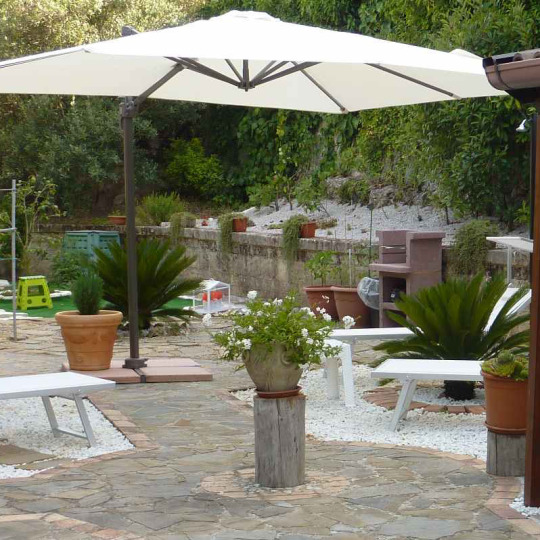
Case vacanze nel Cilento
Prenota la tua vacanza da sogno nel cilento da noi. Vuoi un posto per rilassarti circondato dalla natura incontaminata del cilento? Scegli il nostro appartamento 4 posti Madison house Italia.Telefono: 335 15 72 708. and +44 7454140104. Email: [email protected]

UN GIRO NEI DINTORNI
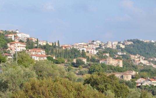
L’abitazione è ubicata a Torchiara, una località del Parco del Cilento, area naturale protetta e da questa posizione si possono raggiungere le seguenti località: Torchiara è un paesino medievale e quindi ospita molti luoghi da visitare che sono:
Palazzo Baronale De Concilis, Torre Mangoni, Chiesa del Santissimo Salvatore.
Lustra, Fortezza,Rocca Cilento,Guglielmo Sanseverino.
Agropoli con le sue spiagge, Baia di Trentova, lo scoglio del sale, lungomare San Marco, Porto turistico. Il centro storico con la salita degli scaloni, la porta monumentale, la cinta muraria e il castello Angioino Aragonese sede di spettacoli e manifestazioni (evento alla Corte di Luisa: teatro, mostra di abiti dal ‘400 all’ ‘800, degustazione di piatti tipici. La Chiesa Madre dei Santi Apostoli Pietro e Paolo, la Chiesa di Santa Maria di Costantinopoli del XVII secolo (il 24 luglio si celebra la caratteristica processione con la statua della Madonna che arriva dal mare). La torre di avvistamento di San Francesco (spiaggia di San Francesco).
Paestum con le sue spiagge precedute da un’ampia pineta, l’area Archeologica dei tre templi: di Hera, di Atena, di Nettuno, la necropoli del Gaudo, il museo Archeologico Nazionale (maggio e settembre “i giorni Romani di Paestum”
I nostri megliu servizii:-
· Ville in affitto nel Cilento
· Appartamenti in affitto nel Cilento
· Case vacanze nel Cilento
· Appartamenti in affitto nel Cilento
· Casa vacanze in affitto nel Cilento
· Case Vacanze Cilento
· Ville nel Cilento
· Case in affitto nel Cilento
· Vacanze nel Cilento
· Case vacanze e appartamenti nel Cilento
Posizione:- Italian
Telefono: +39 335 15 72 708
Cell: +44 7454140104
Visitateci:- https://madisonhousecasevacanze.com/
0 notes
Text
Vacanze nel Cilento
Prenota la tua vacanza da sogno nel cilento da noi. Vuoi un posto per rilassarti circondato dalla natura incontaminata del cilento? Scegli l'appartamento di 4 locali Madison! Telefono: 335 15 72 708. Email: [email protected] Appartamenti in affitto nel Cilento
DESCRIZIONE
Appartamento al piano terra con ingresso indipendente di circa 45 mq. con camera matrimoniale, soggiorno con angolo cottura, bagno, piccolo piazzale esterno ideale per momenti di relax o per colazione, pranzo e cena e posto auto. L’abitazione può accogliere quattro persone di cui due nel comodo divano letto, presenta delle buone finiture e servizi ed è adatto a famiglie con bambini. Casa vacanze in affitto nel Cilento
POSIZIONE
L’appartamento è situato in zona collinare con un ottimo clima d’estate e immerso nel verde. Con l’auto si possono raggiungere facilmente e in poco tempo località turistiche, storiche e balneari. Case Vacanze Cilento
INDIRIZZO
84076 Torchiara (SA) – via contrada Puglisi 20/A.
SERVIZI
Cucina attrezzata (lavastoviglie, forno, frigo, ecc), televisore schermo piatto, lavatrice, wi-fi, riscaldamento autonomo, ferro da stiro, phon, parcheggio gratuito interno. Ville nel Cilento
L’appartamento è dotato di coperte, lenzuola e asciugamani con cambio settimanale.
DESCRIPTION
Ground floor apartment with a 45 sqm private entrance. This one bedroom comprises double bedroom, kitchen and open plan living room, bathroom, and small outdoor space ideal to unwind and relax or to enjoy your meals. Free parking is available. The house can easily welcome four people, two of which will stay on the comfortable sofa bed and two on the king-size bed. The facilities are beautiful and well taken care of. The house is perfect for families with children and pets are allowed. Case in affitto nel Cilento
POSITION
The villa is located in a hilly area known for its excellent summer weather and for being surrounded by greenery. By car, you can quickly reach all tourist attractions, historical places and the marvellous seaside resorts. Vacanze nel Cilento
ADDRESS
84076 Torchiara (SA) – via contrada Puglisi 20/A.
SERVICES
Fully equipped kitchen (dishwasher, oven, fridge, etc.), flat screen TV, washing machine, wi-fi, independent heating, iron, hairdryer, free parking inside the property.
Blankets, sheets and towels are included and changed weekly.
Read More:- https://madisonhousecasevacanze.com/
0 notes
Photo
Torchiara, rinnovo del Direttivo del Forum Giovanile:eletto Presidente Guido Veltre Il Forum Giovanile di Torchiara è giunto al rinnovo del Direttivo. Il giorno 8 febbraio presso l’aula consiliare del Comune di Torchiara, si è svolta l’assemblea elettiva dei membri che ha visto eletto Presidente Guido Veltre.
0 notes
Photo
Un saluto a tutta Torchiara per l ospitalità e la compagnia, aspetto con emozione di partecipare alla @notte del barone l' anno prossimo (presso Torchiara) https://www.instagram.com/p/B1s4VU7gIgb/?igshid=41ph6p1m1dgp
0 notes
Link
This chapter explores the rise of official cartography in sixteenth- and seventeenth- century Europe, paying particular attention to state-sponsored mapping and the role of maps in the rise of the state. It also attends to the place of geography in propagating early modern regimes, whether by means of official court geographers—common especially in France, Spain, and the German and Italian states—or by means of commercial mapmakers, who had more prominent parts to play in the cartographic business of the Low Countries and Britain. Our approach to the subject is comparative. It is also necessarily selective, and, following the work of Harley, it focuses on the ceremonial, ideological, and political uses of maps, while other chapters in this volume address more particularly their administrative and strategic uses.
Richard L. Kagan and Benjamin Schmidt. “Maps and the Early Modern State: Official Cartography.” David Woodward, ed. The History of Cartography, Volume 3: Cartography in the European Renaissance. University of Chicago Press: 2007.
State mapping arose in conjunction with shifts in state government, especially newly developing notions of the space of realm and rule. Central to the emergence of official cartography was the concept of territorial sovereignty: the idea of the state as a precisely defined and delimited geopolitical unit. Aspects of this particular concept of statehood could be found in the classical world, especially in Rome at the time of Augustus. By the Middle Ages, however, territorial sovereignty was all but forgotten, for sovereignty had become a fundamentally legal construct, the equivalent of imperium or majestas, terms that had less to do with territory than with the power to make and enforce law. Sovereignty in medieval Europe was power over people, not place, and only gradually did it begin to encompass ideas of territoriality. In France, for example, the symbolic turning point occurred in 1254, when the royal chancellery, which had previously referred to the monarch as rex francorum, or king of the Franks, officially adopted the title of rex franciae, king of France. Such language was purely ceremonial, to be sure, yet it augured the emergence of a more territorialized notion of monarchy and, by extension, a more cartographic approach to governance itself. As early as 1259, the French monarch Louis IX, in the course of a dispute with the neighboring county of Champagne, attempted to learn about “the beginning and ends of the lands of this kingdom and of the country of Champagne”; he sought, in other words, to map his realms.6 In general, however, this shift toward a more territorialized vision of sovereignty occurred only gradually. Late medieval jurists continued to think of sovereignty as essentially a human, as opposed to a territorial, construct; even in the seventeenth century, Thomas Hobbes could write about the commonwealth without reference to boundaries or frontiers. As Sahlins has pointed out, the idea of territorial sovereignty was only a secondary consideration when, in the Treaty of the Pyrenees (1659), the king of France sat down with his Spanish colleague in an effort to fix a linear border between their respective domains. Traditional jurisdictional considerations weighed more heavily than purely geographical ones, and the treaty that was ultimately drafted defined the area annexed by France simply as the “countries, towns, castles, boroughs, villages, and places” that comprised Roussillon and Conflent.7 The result was a border that was, and remains, idiosyncratic.
Despite the particular failure of this treaty to address territorial sovereignty more directly, by the end of the fifteenth century Europe’s rulers did show signs of being territorially conscious—and map savvy—in ways their medieval counterparts were not. The sources of this consciousness were many. To begin with, the translation from Greek into Latin (ca. 1406 –10) of Ptolemy’s Geography contributed to what has been called the “geometrization” of space, the view that land could be measured and described in precise, mathematical terms.8 As in the case of many other humanist “discoveries,” not everyone was at once affected by this development, and for centuries most maps and views were produced without recourse to triangulation, plane tables, theodolites, and the other surveying instruments equated with the rise of Ptolemaic, or “scientific,” cartography. Nevertheless, by the end of the fifteenth century the ideas of Ptolemy and his many followers competed with, and ultimately challenged, at least two prior concepts of mapping: the Aristotelian notion of describing the land primarily in terms of its utility for humans and the Christian approach of delineating the moral boundaries of space, as was typically done in biblically inspired mappaemundi. Both of these strategies did persist, yet they increasingly gave way to Ptolemaic plotting. For example, new ideas of space worked their way into jurisdictional disputes, which soon sparked the development of a “juridical cartography,” Dainville’s term for maps designed solely to assist judges in resolving disputes.9 These juridical conflicts and their resolutions further contributed to the idea that sovereignty, traditionally conceived in terms of contractual relationships between lords and vassals, could also represent power over particular spaces whose boundaries needed to be measured and mapped. As early as the 1420s, Florence and Milan attempted to resolve a boundary dispute through the use of a map, and by the 1450s a series of jurisdictional disputes with ecclesiastical authorities led the dukes of Burgundy to commission new maps describing the territorial limits of their domains.10 Territorial consciousness of a somewhat different sort prompted Pier Maria Rossi, condottiere-prince of Parma, to record his gains in Emilia by decorating his castle at Torchiara with frescos that showed the fortresses and countryside he had recently conquered (this ca. 1460).11 And one of the most telling signs of the rise of territorial consciousness occurred in the 1494 Treaty of Tordesillas, where Pope Alexander VI divided the non-Christian world between the Spaniards and the Portuguese by drawing a north-south line—the so-called Line of Demarcation— 370 leagues to the west of the Cape Verde Islands. According to the terms of the agreement, all lands to the east of the line belonged to the Portuguese, while those to the west went to Castile. The discovery of the Philippines and other Pacific islands by Ferdinand Magellan sparked a nearly century-long quarrel between the Iberian powers over control of the western Pacific. Nevertheless, the Line of Demarcation offers evidence that by this time even the pope had begun to view the world in territorial, as opposed to strictly jurisdictional (or even religious), terms.
[...]
By contrast, defense against ambitious warlords drove the Italian city-states to map their territories during the conflict-riven fourteenth and fifteenth centuries. Or, to put it in Burckhardtian terms, just as Italian condottieri took the lead in the art of war, laying intricate sieges and constructing expert fortresses, walls, and other defenses, so did Italian engineers take the lead in the art of mapping, which well served their princes in the never-ceasing battles of the day.14 War, first in Italy and later elsewhere in Europe, contributed appreciably to the rise of territorial consciousness. It also spawned a class of individuals, soon to be called surveyors and engineers, who developed the mathematical and charting skills necessary to plot out a city’s defensive requirements in the form of ground plans or maps. It follows that some of Europe’s first ground plans—a sure sign of territorial consciousness— came from northern Italy. An early example is the plot of Milan, produced for the Sforzas around 1430; another is that of the Po Valley town of Imola, attributed to Leonardo da Vinci and completed around 1484 as part of the town’s fortification strategy.15 Like the contemporary plans of dikes and polders in the Netherlands, these texts were working documents, executed for practical purposes. Yet they contributed all the same to the concept of sovereignty as it came to be understood in later years: official control over space rather than people.
[...]
To be topographically wise, as rulers were plainly counseled, is not quite the same as to be in control of one’s realms; knowing the discipline of geography is not the same as disciplining the land. Yet the two trends tended to run in conjunction around this time, and the first half of the sixteenth century witnessed numerous and varied attempts to rein in the land (or sea), graphically no less than politically. Once again, certain Italian precedents stand out. Venice, following its colonial expansion by the early fifteenth century to the mainland, or terra firma, and in the wake of the growing French threat following the 1494 invasion of the peninsula by Charles VIII, instituted a policy of producing surveys and commissioning regional maps to enable it effectively to manage its growing resources. A prominent map of the “state of the Serenissima” (now lost) decorated the doge’s palace.22 The Venetian project offers early evidence of state-sponsored cartography. It may well have been such Italian influences that prodded the centralizing regime of Tudor England toward a similar strategy of mapping. Yet what Barber has called “the Henrician cartographic revolution” (“a profusion of plats . . . by military engineers”) probably grew out of the more particular circumstances of the 1530s, by which time the pope had excommunicated Henry VIII, and an attack by François I of France (aided by Charles V) did not seem out of the question.23 Whatever the stimulus, the English monarchy seized on the device of maps “as tools in the processes of government and administration,” suggesting that Thomas Cromwell well understood the link between cartography and statecraft. 24 The back-and-forth conflicts between Sweden and Denmark may well have instigated the respective Scandinavian crowns to sponsor projects for mapping their realms; there is even talk of a Konglischen Schule of cartography in Copenhagen.25 And in the Holy Roman Empire the crisis of the Reformation may likewise have intensified cartographic undertakings, including, for example, Tilemann Stella’s great surveying project—which, if never fully realized, did produce an important map of Germany in 1560.26
1 note
·
View note
Text
Torchiara, domani l'inaugurazione dell'asilo nido
Si terrà domani mattina l'attesa apertura dell'asilo nido
Si terrà domani mattina l’attesa apertura dell’asilo nido
(more…)
View On WordPress
0 notes
Text
Mi sono fatta...
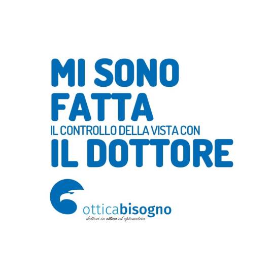
In caso di #Bisogno, c'è Massimo.
Per #prenotare il #controllogratuito è semplice e veloce:
- 081 514 3565 #Roccapiemonte
- 089 955155 #Baronissi
- 0828 956284 #SanGregorioMagno
- 0974 198 7311 #Torchiara
#otticabisogno, #ilmassimodellavisione
0 notes
Last Seen Blogs

melody-web
melody-web

janedesigns
Jane Designs

nomercypercyderolo
Hell Opened Like a Red Rose

iqbal1119
Untitled

luisaleylaph
Untitled