#Urban Bird Observatory
Photo

Hellraiser Park and Urban Bird Observatory in Eugene, Oregon.
#Hellraiser Park#Urban Bird Observatory#Eugene#oregon#pinhead#Hellraiser#antagonist#fictional character#Doug Bradley
736 notes
·
View notes
Photo

Hellraiser Park and Urban Bird Observatory in Eugene, Oregon. Apparently, artist Cabel Adams puts his VR creations in real settings and fools everyone. Still cool idea, though.


Pinhead slide also has telescopes to look at the birds. I didn’t know Pinhead liked birds.
odd, weird,strange and unusual
#pinhead slide#hellraiser park oregon#hellraiser park & urban bird observatory#virtual reality#cabel adams artist
5K notes
·
View notes
Text

⠀⠀⠀𝐃𝐈𝐅𝐅𝐄𝐑𝐄𝐍𝐓 𝐎𝐔𝐓𝐈𝐍𝐆𝐒 & 𝐓𝐑𝐈𝐏𝐒 𝐓𝐎 𝐔𝐒𝐄 𝐈𝐍 𝐑𝐏. ♡
under the cut you'll find a list of 56 diverse outings and trips to use in starters or replies withing plots. this can be used to bring new cenarious to plots, starters and rps, helping to differ threads and put characters in new experiences.
Walking in nature
A bicycle ride
Visit to an art museum
Historical city tour
Boat trip on the river/lake
Mountain trail hike
Visit to a botanical garden
Picnic in the park
Bird watching
Gastronomic tour of the city
Hot air balloon ride
Cave exploration
Visit to a zoo or aquarium
Shopping itinerary in local stores
Winery tour
Panoramic train ride
Visit to historical sites
Trip to a neighboring city
Kayak/canoe trip
Tour of movie locations
Drive-in cinea
Walk on a beach
Visit local fairs and markets
Photo expedition
Horseback riding
Visit to an astronomical observatory
Urban art trail tour
Excursion to a theme park
Traditional cooking class
Helicopter ride
Camping trip
Visit to a cultural festival
Tour of haunted places
Surf lesson or other water sport
Motorcycle ride
Exploring historical ruins
Regional dance class
Treasure hunt tour
Tour of panoramic viewpoints
Rollerblading or skateboarding
Day at an amusement park
Visit to a nature reserve
Quad bike ride
Participation in a local marathon
Wildlife watching
Zip line ride
Tour of architectural monuments
Participation in a spiritual retreat
Sailing boat trip
Motorcycle ride
Visit to a contemporary art exhibition
#rph#rp resources#rp writing help#character help#rp help#plot help#plot development#rpc#writing advice#writingtips#writing tips
305 notes
·
View notes
Text
LAST LIFE APOCALYPSE AU MASTERLIST

A very intensely written Life Series au by ME!
All general updates questions and lore can be found in the #last life apocalypse au tag! This post in particular will act as a masterlist regarding the timeline, worldbuilding and lore of the au. I wish to (hopefully) keep updating this post as more characters and arcs are revealed.
IMPORTANT YOU VISIT THIS LINK FIRST BEFORE ENTERING (It’s pretty):
> Last Life Apocalypse AU Intro (Talks about the mechanics)
Now without further ado - lets begin:
TIMELINE (Summarised)
The timeline of the AU is defined by two major arcs:
The past PROLOGUE 3RD LIFE that is the childhood of majority of the cast (location: their childhood town)
LAST LIFE PRESENT day that takes place in the woods (the main event - when the Apocalypse starts)
These are arcs that involve most if not all of the cast members from their respective seasons.

[BETWEEN ARCS]
Between these arcs occur smaller events - big to some but not on a scale to affect everyone. This is the transition period after the cast graduate from Middle School and go their separate ways before reuniting (by fate) in the Last Life Woods. Events that happen in the between arcs take inspiration from the CC’s other respective series beyond the Life Series.
Some current inspirations: Evo SMP, Hermitcraft (various seasons), Scar’s TCD series, Bdubs’ SOTF. More about their involvement as updates progress.
[SCU SPIN-OFF]
Consider this as an epilogue describing the state of the planet decades after the main cast has died. Not considered a ‘major arc’ as it is not focused on the main cast but exists solely for worldbuilding purposes (because I like it :] ).
WORLDBUILDING
Setting of Last Life takes place in the woods, think of American national parks or camping grounds on a road trip, or the Walking Dead (the telltale game not the show)
CLIMATE:
Generic American woodlands climate but with a less generic winter weather. As the situations for the player’s get more dire, so does the environment around with forecasts for an oncoming snow blizzard from Magic Mountain as the world fades to white.
It is also during this time of year and climate where a creature known as the Wither is rumoured to roam the lands. It is a cryptid that unlike most woodland creatures, the Wither wakes from hibernation only during the Winter when it is cold enough and feasts on a very specific carnivorous diet. In reality this is known as the Patient 0 of the Bogeydisease, born and mutated within the labs of the Research Facility, leading to the downfall desolation of what is now known as the Abandoned Observatory.

MAIN LOCATIONS:
SOUTHLANDS (Camp Southlands) - Were once a popular camping hotspot before the apocalypse. The people who survived there were once camp counselors (Grian, Impulse, Mambo, Martyn, Jimmy). The grounds acted as both a family resort and a summer camp for kids where they are divided into one of the five factions supervised by each counselor:
-MARTYN Counsellor of Athletics and house of the GREEN CATS
-IMPULSE Counsellor of Cooking and house of the YELLOW SUN BEARS
-JIMMY Counsellor of Safety and house of the BLUE DOGS (formerly blue canaries)
-MUMBO Counsellor of Crafts (shop) and house of the BLACK MOTHS
-GRIAN Counsellor of (shenanigans) Arts and house of the RED BIRDS
FAIRY FORT (Fairy Fort Reserve FFR) - A geographically enclosed area dedicated to protecting the land and the endangered animals that are shelter there. Ownership of the Fairy Fort was passed along the generations of Lizzie’s family tree. The people who survived there are park rangers with Lizzie as their lead. They have current beef with the Southlanders as there are many things they disagree with and compete against.
ICE FORT (Shade-E-E’s Gas) - As it’s located near the center of the map, the ethubs ‘Ice Fort’ is one of the only ounces of urban infrastructure out in the woods. Upon arrival of the Apocalypse, it is a fortified Shade-E-E’s gas station barricaded by the only employees Bdubs and Etho (the manager). It once acted as a pitstop to drivers and travelers alike and is the only place in the woods that has a working cellphone tower and final connection to the outside world dubbed as “Etho’s Tree”.
TEAM BEST HIDEOUT / ROCKTAPUS (Abandoned Observatory/Research Centre) - An abandoned observatory squatted on by Skizz that doubled as a bunker that was originally built in preparation for a nuclear fallout. Upstairs the observatory contains secret government documents regarding information about the Bogeydisease and the Wither cryptid - Indecipherable to all except for Tango who understands them. Downstairs the bunker’s monitors are linked to several surveillance cameras in the woods.
GASLIGHT GIRLBOSS GATEKEEP (Scottage Club) - A retreat saved for the rich and elite. While the Scottage Club has its HQ here, holiday properties of its patrons are scattered all across the map (the secret green lives hideouts).
MAGIC MOUNTAIN - Kept off limits just for how dangerous the place is, no one ever goes there. Rumor has it the mountain has magic capabilities that can drive a man insane. The last human sightings near Magic Mountain were two lone hikers who by arrogance wished to conquer and come back surviving the woodland’s most treacherous point. And while they were never seen again, they say if you look very closely with a spyglass, you can catch glimpses of a small, broken up hut at the top.
THE NETHER (NETHERLANDS not-the-country):
The NETHER is the closest town over from the Last Life woodlands and is home to facilities such as a Fortress Dept Store and a camping & fishing shop known as The Bastion. While hypothetically the cast could escape the woodlands to live in the Nether, it is because of the high value resources that can be found in these stores that attract both surviving scavengers and zombies alike - making the town very dangerous to defend.
The ‘nether portals’ in this au are the vehicles each team has on them to travel between locations. The Nether may be the closest town there is, but even walking there on foot is extremely dangerous - especially considering the apocalypse and the harsh elements.
BOGEYDISEASE
For legal reasons, I dropped biology in highschool as soon as I could - I do not know shit about diseases and how people develop medicine. This is a fictional disease. TLDR; I am talking out of my ass.
[Origins of the Bogeydisease and the L.I.F.E antidotes pending (secret!)]
Transfer of the disease in its early stages of evolution could only be transferred if bacteria had direct contact with the host’s bloodstream. At best (?) in small amounts the host would experience a fever and shivering. At worst the host would feel extreme fatigue, most likely dying of starvation/dehydration due to it being unaware of their hunger (and fatigue - the disease manipulates the brain into thinking the host is not fatigued).
Nature of the disease (well.. virus) as it continues is designed to adapt with the changing environment. While most samples were not able to survive its effects, some victims of the Wither’s bite would survive and exhibit a second stage of the disease’s effects. If the host were to survive the initial stages of the disease, once the disease has fully adapted to the body of its host it would evolve in order to prolong its survival. This is evident by physical alterations of the host’s appearance.
Not just physical changes but behavioural as well. The host would act more akin to serving its natural instincts, more inclined to the hunt and the tendency to keep itself alive.
People who are in the second stages and beyond of contracting the Bogeydisease are considered Red Lives. It is possible to cure Red Lives out of the Bogeydisease as long as the disease has not evolved to its later stages.
WHEN a person is cured using a L.I.F.E antidote they may experience side-effects [explained in the INTRO]. In some instances, ex-hosts may retain some of the traits afflicted when they were Bogey.


Later stages of disease evolution. The disease and its hosts show strong similarities to how rabies can be passed between hosts. And based on how a host reacts to the disease, hosts of the disease are classified into two types:
Host is overwhelmed by the effects of the disease and dies early. If the body and surrounding scene are left untreated, the disease will continue to live on in the decomposing body and grow a special fungus that feeds off the remains. The fungus and its disease reproduces by its spores which allow the disease to not only infect the environment around but also proves the possibility in contracting an airborne variant of the disease.
Host grows accustomed to the effects of the disease exhibiting the aforementioned loss of higher brain functions above (incapable of reason and rational thought). Movements grow erratic, constantly moving as a means of maintaining fixed body temperature. For colder climates the diet of hosts relies on feasting on warm bodies. Failure to do so will induce drowsiness in the host, placing them in a slumber in order to regain energy and try again.
Hosts also show signs of excessive salivation and occasional bleeding. Direct exposure to any of the host’s bodily fluids is another method in contracting the disease.
[ REMINDER THIS IS AN ONGOING AU , MORE TO BE UPDATED ]
#stufffsart#myart#last life apocalypse au#last life smp#last life#life series#life smp#trafficblr#mcyt#mcyt fanart#long post#everything written on a google doc in advance :]c
588 notes
·
View notes

Text
168 New Nazca Geoglyphs Discovered
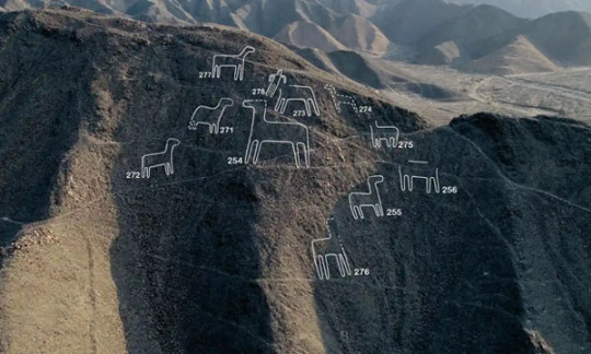
More than 100 new designs discovered in and around Peru's Nazca plain and surrounding areas could bring new information to light about the ancient artworks that have intrigued scientists and visitors for decades. Following two years of field surveys with aerial photos and drones, Peruvian and Japanese researches from Yamagata University reported the discovery of 168 new designs at the Unesco World Heritage site on Peru's southern Pacific coast.
The geoglyphs, huge figures carved into the South American desert, date back more than 2,000 years and depict living creatures, stylized plants and imaginary beings, as well as geometric figures several kilometres long. Jorge Olano, head archaeologist for the Nazca Lines research program, said the newly discovered figures averaged between 2 and 6 meters (6.56 to 19.7ft) in length.
The purpose of the Nazca Lines, which could only be seen from the air, remains a mystery. These new findings, however, are smaller and can be seen from the ground. The figures, iconic vestiges of Peru's rich history, are about a three-hour drive from the capital, Lima. Researchers had already discovered 190 figures in the area since 2004. But the vastness of the terrain they cover has complicated efforts to study and conserve the heritage site.
Yamagata University said the research will be used in artificial intelligence-based surveys to help inform the lines' preservation. Studies from the university in collaboration with Peru's government have helped delineate and protect the area, which is facing threats from urban and economic developments. Some geoglyphs are in danger of being destroyed due to the recent expansion of mining-related workshops in the archaeological park.
Anthropologists, ethnologists, and archaeologists have studied the ancient Nazca culture to try to determine the purpose of the lines and figures. One hypothesis is that the Nazca people created them to be seen by deities in the sky. Another theory is related to astronomy and cosmology, as has been common in monuments of other ancient cultures: the lines were intended to act as a kind of observatory, to point to the places on the distant horizon where the sun and other celestial bodies rose or set at the solstices.
Other theories were that the geometric lines could indicate water flow or irrigation schemes, or be a part of rituals to "summon" water. The spiders, birds, and plants may be fertility symbols. It also has been theorized that the lines could act as an astronomical calendar, as proved by the presence of radial centers aligned along the directions of winter solstice and equinox sunset. Researchers believe that the geoglyphs were the venues of events linked to the agriculture calendar. These also served to strengthen social cohesion among various groups of pilgrims, sharing common ancestors and religious beliefs.
8 notes
·
View notes
Photo

Shrinking Lakes of the Kashmir Valley Two lakes surrounded by the high Himalaya Mountains are remnants of a much larger ancient lake in India’s Kashmir Valley. While the freshwater lakes are some of the largest in the Jammu and Kashmir region of northern India, in recent years they have been in decline. The two lakes—Wular and Dal—are visible in this image, acquired on June 23, 2020, by the Operational Land Imager (OLI) on Landsat 8. Both lakes regulate water flowing down from Himalayan glaciers and along the Jhelum River, supplying water for drinking and irrigation. Dal, in the lower right of the image, is the smaller of the two water bodies. Dal is located in the heart of Srinagar—the largest city in the valley. Floating house boats, markets, and marshes lure tourists to the lake. It is surrounded by terraced gardens—laid out in the 16th and 17th century by Mughal emperors—that are lined with fountains and planted with a variety of flowers, herbs, and aromatic plants. Wular Lake, to the left in the image, is the largest freshwater lake in India, and among the largest in Asia. This 17-square-mile (45-square-kilometer) lake along the Jhelum River provides fish and freshwater to nearby residents. Several wetlands are located on the fringes of the lake and serve as habitat for migratory birds, such as ducks, shorebirds, geese, and cranes. Because of its significance for biodiversity and livelihoods, Ramsar International designated the lake as a “wetland of international importance” in 1990. Bright green flora stands out in the image on the eastern side of Wular. An influx of sediment and nutrients into the lake over the past few decades has contributed to the rapid growth in algae and aquatic vegetation. The lake is now suffering from eutrophication—an overgrowth of plants and algae that can eventually cause oxygen depletion in aquatic environments. The conversion of forests to paved urban areas is a major driver of the change in water quality. Land conversion has delivered heavy sediment and nutrient loads into the lake, and untreated sewage from urban areas has also contributed. Researchers in India used water samples and data from Landsat satellites to assess the biological health of the lake. They found that about 57 percent of Wular Lake was eutrophic in 2018. Some of the bright green area on the eastern side of Wular Lake used to be open water. Nutrient-rich sediment and aquatic vegetation have filled in parts of the lake and contributed to its shrinking in recent decades. In a 2022 study, researchers in India—using data from the Indian Space Research Organization’s (ISRO) LISS-IV instrument—found that Wular Lake’s open water area had shrunk in size by about one-quarter between 2008 and 2019. The smaller Dal Lake has suffered a similar fate in response to land cover change. Researchers in Srinagar found that land conversion to urban development in the basin had worsened the lake’s water quality and contributed to its reduced size. They found that between 1980 and 2018 the lake shrunk in area by 25 percent. NASA Earth Observatory image by Wanmei Liang, using Landsat data from the U.S. Geological Survey. Story by Emily Cassidy.
2 notes
·
View notes
Text
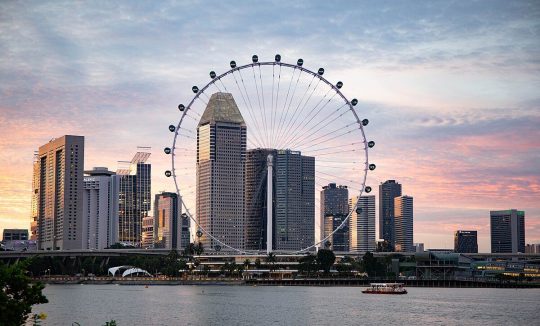
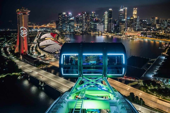
Singapore Flyer: Soaring High Above the Lion City
Introduction:
Located in the heart of a vibrant city-state, the Singapore Flyer is elevated as a symbol of modernity and elegance. Because it’s the world’s largest observatories, visitors are given a breathtaking view of the Lion City skyline. Join us in exploring this iconic landmark, made even more simple and unique with Trip Cabinet’s exclusive Singapore itinerary. Anyone looking to get a bird’s eye view of Singapore, discover why they travel on Singapore Airlines.
Embracing the Skies:
Architectural Marvel: Singapore Flying is not just a cycle of observation; It is a marvel of engineering and design. Because Standing 165 meters above sea level, it offers an unparalleled vantage point from which to take in the architectural splendor of the city, from the Marina Bay Reits to the lush green Gardens by the Bay, all with a well-thought-out itinerary from the Trip Cabinet. It fits perfectly in the list.
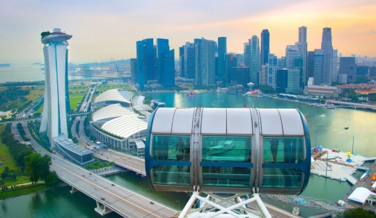
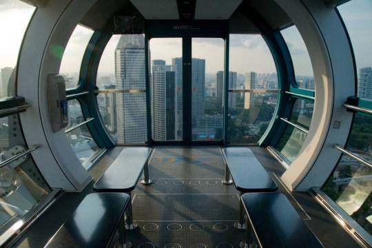
360-Degree Panoramic Views: Step into the spacious, airy capsules, each designed for optimal comfort and unobstructed views. After the slow circle of the Singapore Flyer, the ever-changing landscape unfolds before your eyes. 360-degree panoramic views of the city’s breathtaking skyline showcase breathtaking landscapes and bustling life below. The travel cabinet ensures that your tickets are safely stored, giving you a hassle-free experience.
A Journey through Time:
Day and Night Experience: Whether riding the Singapore Flyer by day or taking in the bright lights of the city at night. Each experience offers a different thrill Day rides can view the city’s architecture and urban planning, and nightlife turns the landscape it will be a warm tapestry Trip Cabinet’s flexible schedule times you perfectly because your ride can be chosen.
Capturing Memories: Don’t forget your camera! The Singapore Flyer is a photographer’s dream. Take in the stunning cityscape, the sparkling waters of Marina Bay, and the spectacular city lights. Trip Cabinet curates an immersive experience by equipping the capsules with interactive touch screens that provide information about the landmarks you see, enhancing your photographic journey.

Unwind and Indulge:
Sky Dining: Elevate your experience of Sky Dining aboard Singapore Flyer with the expertise and comfort of Trip Cabinet. Enjoy a sumptuous culinary journey while savoring delicious food in a private capsule. All while enjoying the ever-changing views of the city it’s the perfect blend of gastronomic delight and visual spectacle.

Flyer Lounge: For those looking for a more relaxed experience, the Flyer Lounge offers a lounge with a drink. The relaxed atmosphere is breathtaking, making it the ideal place to relax and ensure a seamless transition to your flyer experience with the Trip Cabinet itinerary.

Practical Tips for a Seamless Experience:
Book in Advance: Secure your spot and avoid the long queues by booking your Singapore Flyer tickets in advance through Trip Cabinet.
Timing is Key: Consider your time in the car. The golden hours around sunset create a magical play of colors over the city.
Conclusion:
Made simple and unique by Trip Cabinet’s unique travel system The Singapore Flyer is more than just a sightseeing wheel; It is an immersive journey through the heart of the Singapore skyline. From architectural marvels to vibrant city lights, this iconic landmark offers an experience that combines sights and adventure so, whether you are a first-time visitor or a traveler with skilled Don’t give a chance to climb up in Singh City and witness its beauty in an unlikely way. Singapore Flyer beckons, promising a journey that will leave you with memories etched on the canvas of the city’s ever-changing skyline. With the accompanying comfort and familiarity of Trip Cabinet’s Singapore Tour Package.
#SingaporeFlyer#TripCabinetExperience#SkylineViews#FlyHighSG#ObservationWheel#LandmarkAdventures#LuxuryTravel#CityscapeMagic#TravelWithTripCabinet#WanderlustSingapore
0 notes
Text
Dark-sky movement
https://en.wikipedia.org/wiki/Dark-sky_movement
The dark-sky movement is a campaign to reduce light pollution. The advantages of reducing light pollution include an increased number of stars visible at night, reducing the effects of electric lighting on the environment, improving the well-being,[1] health[2] and safety[3] of both people and wildlife,[4] and cutting down on energy usage. Earth Hour and National Dark-Sky Week are two examples of such efforts.
The movement started with professional and amateur astronomers alarmed that nocturnal skyglow from urban areas was blotting out the sight of stars. For example, the world-famous Palomar Observatory in California is threatened by sky-glow from the nearby city of Escondido and local businesses.[5] For similar reasons, astronomers in Arizona helped push the governor there to veto a bill in 2012 which would have lifted a ban on illuminated billboards.[6]
Nocturnal animals can be harmed by light pollution because they are biologically evolved to be dependent on an environment with a certain number of hours of uninterrupted daytime and nighttime. The over-illumination of the night sky is affecting these organisms (especially birds). This biological study of darkness is called scotobiology.[7] Light pollution has also been found to affect human circadian rhythms.[8]
The dark-sky movement encourages the use of full-cutoff fixtures that cast little or no light upward in public areas and generally to encourage communities to adopt lighting regulations. A 2011 project is to establish "dark sky oasis" in suburban areas.[9]
0 notes
Text
The Mountain Topography Surrounding Hollywood, California
Tours of Hollywood Sign and More
Hollywood sightseeing tours all include spectacular (and cost-free) views of the surrounding mountains (the famous Hollywood Hills) but just how much do you know about the topography of this part of the city of Los Angeles?
The vibrant city of Hollywood, California, renowned for its glitz and glamour, is nestled in the heart of Los Angeles County. Beyond the bustling urban landscape, Hollywood is enveloped by a picturesque mountainous terrain. This article explores the fascinating mountain topography surrounding Hollywood, providing insights into its geology, prominent peaks, recreational opportunities, and the breathtaking views they offer to residents and visitors alike.
Geological Background
The mountainous landscape around Hollywood owes its origins to the complex geological history of the region. The area lies within the southern portion of the Santa Monica Mountains, a range that stretches approximately 40 miles parallel to the coast of Southern California. The Santa Monica Mountains are part of the Transverse Ranges, which were formed by the tectonic forces of the Pacific and North American plates. Over millions of years, uplift, faulting, and erosion shaped the mountains we see today.
Prominent Peaks
Several notable peaks dot the mountainous terrain around Hollywood, offering stunning vistas and recreational opportunities for outdoor enthusiasts. Mount Lee, crowned by the iconic Hollywood Sign, is a prominent feature that rises to an elevation of 1,708 feet. Griffith Observatory, situated atop Mount Hollywood (1,625 feet), provides breathtaking panoramic views of the cityscape, the Pacific Ocean, and the surrounding mountains. Another prominent peak is Cahuenga Peak (1,820 feet), located within Griffith Park, offering commanding views of the San Fernando Valley.

Recreational Opportunities
The mountainous landscape surrounding Hollywood provides a haven for outdoor activities and recreation. Griffith Park, one of the largest urban parks in the United States, offers an extensive trail network for hiking, jogging, and horseback riding. The popular Griffith Observatory and its surrounding trails provide opportunities for both nature exploration and stargazing. Runyon Canyon Park, located just south of the Hollywood Hills, is a favored destination for hiking, with trails offering panoramic views of the city and the Pacific Ocean. These mountains also attract rock climbers, who can challenge themselves on the steep cliffs and boulders that punctuate the landscape.
Flora and Fauna
The mountainous terrain surrounding Hollywood supports a diverse array of flora and fauna. Chaparral, characterized by drought-tolerant shrubs, dominates the landscape. Common plant species include California sagebrush, toyon, and coastal sage scrub. The mountains are also home to a variety of wildlife, including deer, coyotes, bobcats, and numerous bird species. Protected areas within the mountain range, such as the Griffith Park Nature Reserve, ensure the preservation of these natural habitats.
Breathtaking Views
The mountain topography around Hollywood offers breathtaking views that have captured the imagination of artists, photographers, and visitors for decades. The panoramic vistas from Griffith Observatory showcase the sprawling cityscape of Los Angeles, the glimmering Pacific Ocean, and the silhouettes of neighboring mountain ranges. Atop Cahuenga Peak, one can marvel at the sweeping vistas of the San Fernando Valley, extending to the majestic Santa Susana Mountains. These awe-inspiring views serve as a reminder of the natural beauty that coexists with the vibrant urban setting of Hollywood.
youtube
The mountain topography surrounding Hollywood adds a natural grandeur and serenity to the bustling cityscape. From the iconic peaks like Mount Lee to the panoramic views from Griffith Observatory, these mountains provide a refuge for outdoor enthusiasts and a source of inspiration for those seeking respite from the urban bustle. The diverse flora, fauna, and recreational opportunities within this mountainous landscape create a unique juxtaposition with the glitz and glamour of Hollywood, enhancing the overall charm of the region.
0 notes
Photo

ℌ𝔢𝔩𝔩𝔯𝔞𝔦𝔰𝔢𝔯 𝔓𝔞𝔯𝔨 𝔞𝔫𝔡 𝔘𝔯𝔟𝔞𝔫 𝔅𝔦𝔯𝔡 𝔒𝔟𝔰𝔢𝔯𝔳𝔞𝔱𝔬𝔯𝔶!
#Hellraiser#pinhead#park#urban bird#Observatory#eugene#oregon#random#horror aesthetic#terror aesthetic#antagonist#fictional character
6K notes
·
View notes
Text
Beyond the Skyscrapers - Dubai's Natural Wonders and Outdoor Adventures
Dubai, known for its iconic skyscrapers and luxurious lifestyle, offers more than meets the eye. Beyond the dazzling cityscape lies a treasure trove of natural wonders and thrilling outdoor adventures waiting to be explored.

Nature enthusiasts can discover the stunning Dubai Desert Conservation Reserve, a vast expanse of golden sand dunes where one can embark on exhilarating desert safaris, dune bashing, or even camel riding. The reserve also hosts indigenous wildlife, including the graceful Arabian oryx and gazelles, offering a glimpse into the region's rich biodiversity.
For those seeking aquatic escapades, Dubai's pristine coastline beckons with crystal-clear waters. Dive into the depths of the Arabian Gulf to encounter vibrant coral reefs teeming with colorful marine life, or indulge in thrilling water sports such as jet skiing, parasailing, or paddleboarding.
Escape the bustling city and venture into the Hajar Mountains, a breathtaking natural wonder just a short drive away. Hiking enthusiasts will find themselves surrounded by rugged peaks, hidden valleys, and picturesque waterfalls, providing an ideal setting for outdoor adventures and breathtaking panoramic views.
Dubai's commitment to sustainability is evident in its eco-friendly initiatives. Explore the mesmerizing Al Qudra Lakes, a serene oasis nestled amidst the desert, where migratory birds flock, and visitors can enjoy kayaking or cycling along the scenic trails.

As the sun sets over Dubai, the city transforms into a stargazer's paradise. Head to the Dubai Astronomy Group's observatory and witness the celestial wonders of the night sky, away from the urban lights.
Dubai's natural wonders and outdoor adventures offer a refreshing contrast to its urban extravagance. Embrace the untamed beauty, delve into thrilling experiences, and create unforgettable memories beyond the skyscrapers, discovering a side of Dubai that is as awe-inspiring as it is unexpected.
1 note
·
View note
Text

Madrona Marsh Preserve and Nature Center
The Madrona Marsh Preserve and Nature Center is a wildlife oasis located in the city of Gardena, California. The nature center and nature preserve protects and restores an area of coastal wetlands, allowing visitors to experience the beauty and biodiversity of salt marsh habitats in Southern California.
The nature center features a large number of interactive educational exhibits, art exhibits, and educational programs. There are also walking trails and bird observatories that offer excellent opportunities to view local wildlife such as migratory birds, butterflies, insects, and small animals.
Also Read,
The Links at Victoria Golf Course
The nature reserve itself is a fascinating place to explore. Covering over 40 acres of land, it is home to a variety of plant and animal species. Visitors can walk the trails and raised bridges to view wildlife such as frogs, ducks, herons, and other birds.
The Madrona Marsh Preserve and Nature Center is a wonderful opportunity to learn about and connect with nature in a calm and relaxing environment. It is a popular destination for nature lovers, wildlife photographers, and local residents looking for a quiet escape from urban life. With its rich natural environment and hands-on education, this place is a must-see for those who want to explore the biodiversity of Southern California.
0 notes

Text
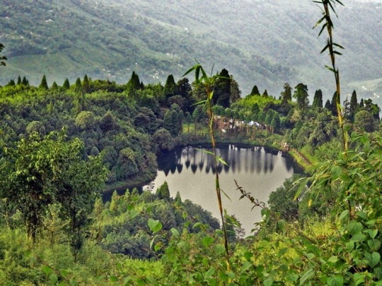
Best Places to visit in Darjeeling
One of the most popular hill stations in India - Darjeeling is a complete collage of snowy and powerful Himalayan mountain ranges, winding walking tracks, valleys, monasteries, momos, tea gardens and toy trains. Between the green-gray hills, serene vegetation and scenic views ensure a vacation forever. The untouched beauty of this mountain town attracts visitors from all over the country and takes a break from urban life. So, dive into this list of the best tourist destinations of Darjeeling that you do not want to miss your trip.
Tiger Hill

One of the best tourist destinations in Darjeeling, Tiger Hills is the perfect package for a nature lover. If you can tolerate the bitter cold, climb this hill to witness the impressive first rays of the sun on Mount Everest. Drive on Tiger Hill before sunset and adjust your camera setting and shutter speed for a mesmerizing aura. It occurs in the blink of an eye.
Batasia loop
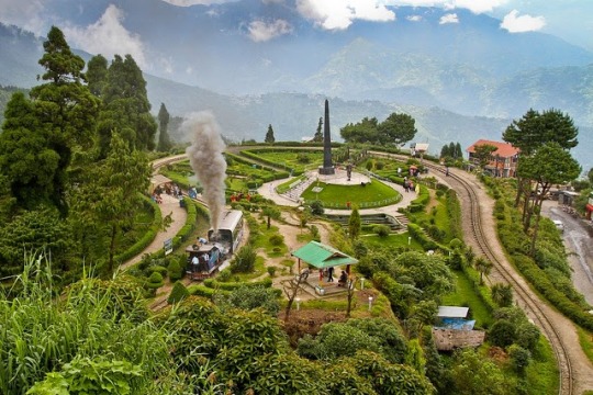
This elevated area below the ghum has a spiral railway track through a tunnel at the summit. What adds to the panoramic view is a nicely decorated garden area that offers complete solitude. It is the vast expanse of planned greenery that makes Batasia Loop one of the best tourist destinations in Darjeeling that every tourist should visit.
Ghoom Monastery

Also known as Yiga Choiling Monastery, Darjeeling's popular tourist destination lies just below the Ghoom railway station. The monastery is one of the oldest in the region and reflects the ancient glory of Buddhist culture.
Himalayan Railway Station
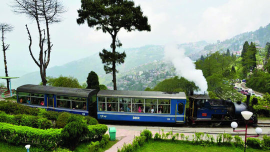
Other top tourist destinations in Darjeeling include the Toy Train which starts at New Jalpaiguri and ends at Darjeeling. Situated in the lap of the Himalayas, this station is a beautiful place. A UNESCO World Heritage Site, this railway station is used for shooting many documentaries and films.
Himalayan Mountaineering Institute
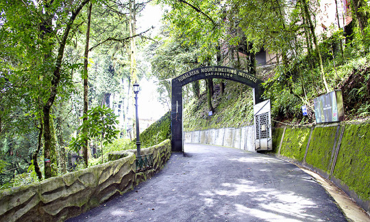
One of the reasons why people visit Darjeeling is the Himalayan Mountaineering Institute. Aspiring mountaineers and amateurs come to this place for training and to adapt themselves to the mountains as it is known as one of the best mountaineering institutes in India. The reason it has become a significant tourist attraction is that it is set in a stunning backdrop located on top of a mountain.
Darjeeling Observatory Hill

The Observatory Hill is one of the best tourist attractions in Darjeeling, located on a hill above Chorasta Square, 2 km from Darjeeling Himalayan Railway Station. This is one of the places to visit in Darjeeling which is surrounded by Hindu and Buddhist temples. Some of the famous temples in the area include Kanchenjunga Temple, Mahakal Temple, and Tibetan Memorial Shrine.
Darjeeling ropeway

Who would want to say no to the panoramic view of Darjeeling that can be captured in one picture? No one, right? So, the next place to see in Darjeeling is the ropeway attraction where you can get a cable ride and get a bird’s eye view of the mountain town. Do you want to believe the fact that Darjeeling Ropeway is the first cable car system in India which was established in the year 1968? After hopping on this car, if you travel in the winter season, you can expect a breathtaking view of the exquisite landscapes covered with tea gardens and snow. If you don't want to miss this, be sure to include it in your to-do list this year.
Senchal Lake and Wildlife Sanctuary
How can the journey to Darjeeling be completed without visiting this beautiful place of Darjeeling which gives both nature and animal lovers the opportunity to witness the beauty of nature in the best possible way? The Sanchal Wildlife Sanctuary covers an area of about 40 square kilometers. You can see tall animals here including the Himalayan black bear, rhesus monkey, barking deer, Himalayan flying squirrel and many birds. Lake Senchal is a source of drinking water for the entire hill town and forms only a part of the wildlife sanctuary. This is a great place for animal and nature lovers to visit Darjeeling.
Rock Garden

Darjeeling Rock Garden is one of the famous tourist destinations of Darjeeling. It is a man-made rocky garden rich in vegetation, waterfalls and bridges. With plenty of activities for extensive expansion, the park is a popular tourist destination in Darjeeling. So, if you are visiting Darjeeling with your family, visit this garden!
With this list of places to visit in Darjeeling, you are sure to cover all parts of the tour that will make for great memories. So, head over to Darjeeling and create your itinerary with the top places to visit in Darjeeling.
#sikkim darjeeling tour packages#sikkim tour packages#darjeeling tour packages#holiday tour packages#travel agent in ahmedabad#diwali tour packages#family tour packages
0 notes
Text
Swifts on alarming decline in the UK as some fear 'extinction' amid climate change patterns
New Post has been published on https://petnews2day.com/?p=51452
Swifts on alarming decline in the UK as some fear 'extinction' amid climate change patterns
Reportedly there have been fewer sightings of Swifts this year, leaving nature lovers and bird watchers concerned. There was a sharp plummet in the numbers of the beautiful bird, with figures dropping by more than 50 per cent since 1995.
This year, with the birds set to return to the UK as part of their migratory pattern, their absence has not gone unnoticed with discussion started on what could have happened to the beloved bird. Nature writer and presenter Kate Bradbury took to Twitter to express her dismay.
She said her allotment in Brighton didn’t have a “single” Swift. Writing online, she said: “Please, where are the Swifts? I didn’t see a single one yesterday. The usual gang of 20 at my allotment is just four this year.
“I could go on. I know they’re declining but this seems a big drop from last year. Is it just Brighton? Did they not come? Does anyone know?”
READ MORE: ‘Alarming’ invasive species of bird threatening UK wildlife spotted in Kent
People reacted online that they have noticed something similar. Underhill Wood Nature Reserve responded: “Same with house martins/swallows…each summer we had up to 50 birds drinking bathing and hunting over the lake @Underhillwood.
© Twitter
The Nature writer and presenter took to Twitter over her alarm
“Last two years none. Are we witnessing an extinction with these species?”
Nicola Chester said: “So very few. Also swallows, here. Seen, but not nesting in usual places. Heartbreaking, to the point of panic at the thought Kate.”
And Lesley Bagshaw added: “I’ve been posting about this on a local group in Monmouthshire. For the first time for 20 years I don’t have them in the eaves. A tiny number fly over occasionally. Replies all say the same. I’m sadly searching the skies every day.”
But Urban Advisor for the Royal Society for the Protection of Birds (RSPB) said, although bird numbers are down more than average, that doesn’t mean the Swift populations are in decline. He told KentLive: “BirdTrack reporting rates for Swifts are down on average this year and also noted are those of House Martin and Swallow. But that does not suggest a decline.
“Each year, non-breeding birds of many species arrive later than the established population, and migrants of different species are even now being recorded arriving at many coastal observatories. For the Swift, the non-breeding population has only just begun to arrive and, over the coming weeks, these will gradually increase the observed numbers.
“Data gathered this year through the annual Breeding Bird Survey (BBS) will not be analysed and published until 2024. Only then will we have an indication of any decline or otherwise in numbers of our breeding bird populations – including Swift, for this year.”
However, he added that in the latest review of the Birds of Conservation Concern, both Swift and House Martin were moved from Amber to Red due to steep declines of over 50 per cent in recent years – 58 per cent and 75 per cent respectively. The causes of the decline are not fully understood.
But in the case of the Swift, it is the loss of established nesting sites due to renovation and demolition that has massively contributed to the decline of the population. Also, modern buildings are more sealed to provide better insulation, which also means fewer nesting places.
In order to help increase the population of Swifts, you should:
Put up nest boxes on your house, these can be purchased through the RSPB shop HERE
Comment on local planning applications for developments, asking that Swift boxes are integrated into the fabric of new builds, as per British Standard BS42021
Use Swift Mapper to record groups of Swift’s flying around buildings (this indicates nesting nearby) or actual nests (difficult to find)
Start your own local Swift group and join over a 100 like minded groups across the country
Swift Mapper is an easy to use desk top and mobile phone app enabling records to be entered from anywhere while you’re on the move. You can access it HERE
Start your own local Swift group and join over a 100 like minded groups across the country. Information on the Swift Local Network can be found HERE
Source link
0 notes
Last Seen Blogs

marleysmellowmood
Marley's Mellow Mood

emiliasilverova
Janus Central

sexilydrawn
SexilyDrawn

jungkookstatts
Jungookstatts Blog