#WeatherMonitoring
Explore tagged Tumblr posts
Visit Tumblr Blog
Explore Tumblr blogs with no restrictions, modern design and the best experience.
Last Seen Tumblr Blogs


Fun Fact
Kazakhstan’s Minister of Communications and Informatics has blocked the Tumblr site because it contained 60 sites of terrorism, extremism, and pornography in 2015.
Photo
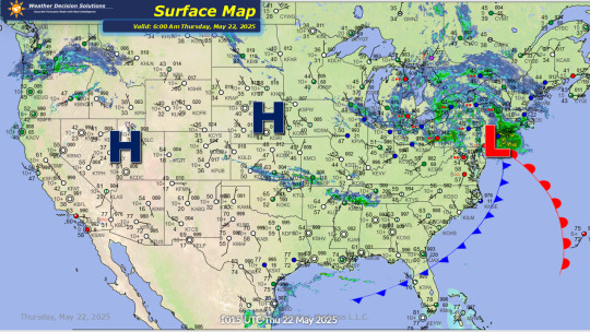
Weather Decision Solutions is monitoring a developing low-pressure system along the eastern seaboard, which is expected to intensify into a significant coastal storm. This storm will bring powerful winds with gusts reaching up to 60 miles per hour along the New England coast, extending all the way up to Maine, accompanied by heavy rainfall in the region. In the mountainous areas, snowfall is anticipated, with up to 8 inches possible over some of the higher peaks in the northeastern U.S. Meanwhile, rain will persist across parts of the Eastern Great Lakes, the Ohio Valley, and into the Appalachians and Mid-Atlantic regions, with temperatures remaining below normal. Additionally, the Pacific Northwest will see more rain as the next system approaches and is set to deliver further rain and thunderstorms across the country this weekend. 🌧️⚡️ #WeatherUpdate #CoastalStorm #NewEnglandWeather #HeavyRain #HighWinds #Snowfall #NortheastWeather #EasternSeaboard #PacificNorthwest #Thunderstorms #BelowNormalTemps #WeatherMonitoring 🌧️⚡️
#WeatherUpdate#CoastalStorm#NewEnglandWeather#HeavyRain#HighWinds#Snowfall#NortheastWeather#EasternSeaboard#PacificNorthwest#Thunderstorms#BelowNormalTemps#WeatherMonitoring
0 notes
Text
#AccurateDeals#HomeWeatherMonitoring#BestWeatherStations#HomeWeatherProducts#ComprehensiveGuide#WeatherMonitoring#SmartHomeDevices#WeatherTech#WeatherInstruments#HomeWeatherSystems#WeatherTracking#SmartHomeWeather#WeatherForecasting#WeatherMonitoringGuide#WeatherStationDeals#AccurateWeatherDevices#WeatherGadgets#HomeMonitoring#WeatherAccuracy#WeatherData#WeatherStationReviews#BestHomeMonitoring#SmartWeatherSystems#HomeWeatherAccuracy#WeatherStationBuyingGuide#WeatherSensorTechnology#WeatherMonitoringDevices#HomeWeatherTracking#WeatherProtection#WeatherAlertSystems
1 note
·
View note
Text

🌡️ Elevate your precision with the BRANNAN Gilt Dial Max Min Thermometer and Hygrometer! An instrument of accuracy and style. Explore the world of measurements at ANBI Solutions.
Shop Now : https://shorturl.at/ghuvC
#Thermometer#Hygrometer#BRANNAN#Instrumentation#PrecisionTools#TemperatureControl#WeatherMonitoring#ANBISolutions#OnlineShopping#HomeImprovement
1 note
·
View note
Note
This is so sad. 🙏
https://x.com/WeatherMonitors/status/1904529323392172129?t=91vrB3dSUIXSMwZKyOkqMg&s=19
https://x.com/volcaholic1/status/1903760581015805987?t=91vrB3dSUIXSMwZKyOkqMg&s=19
Oh my god this is terrifying, I hope no one got hurt.
2 notes
·
View notes
Text

🌟 Exciting News from Opulance Technologies! 🌟
Introducing our latest invention: the Advanced Automated Weather Station. This cutting-edge technology delivers real-time, accurate weather data to help you stay ahead of the elements. Perfect for meteorologists, farmers, and weather enthusiasts alike. Discover the future of weather monitoring with Opulance Technologies! 🌦️🔬 #OpulanceTech #WeatherStation #Innovation #RealTimeData #WeatherMonitoring
#iot development services#iot platform#iot tech#iotinnovation#iot in agriculture#robotics#tech#lgbt#iotdevices
2 notes
·
View notes
Note
After seing the chaos and disgraceful organisation and communication from the government of Valencia to the population this is wonderful organisation. Take care people
https://x.com/Weathermonitors/status/1860715423857000578?t=Xn5NG7jRNFUtp7YaLOmmig&s=19
I'll give credit to the English when they want to be organized they definitely can be
0 notes
Text
New: Flood in Singapore no play play lah
🚨🇸🇬HEAVY RAIN CAUSES ISLAND-WIDE FLOODINGDATE: October 14, 2024Sudden downpour overwhelms drainage systems, inundating roads and affecting vehicles.KEY AFFECTED AREAS:– Bukit Timah– Multiple locations across #SingaporeSTAY INFORMED! #Flood #Rain pic.twitter.com/uGIFjLXCie— Weather monitor (@Weathermonitors) October 14, 2024 In Malaysia, the PAS asked the Menteri Besar of Selangor to resign…
0 notes
Text
"Future Directions in Integrated 3D Radar Technology (2024-2033)"
Integrated 3D Radar Systems are revolutionizing surveillance and detection technologies by providing advanced, multidimensional insights into target environments. These cutting-edge systems combine radar technology with sophisticated data processing to deliver precise, real-time 3D imaging and tracking of objects, whether stationary or in motion. Used in applications ranging from aerospace and defense to autonomous vehicles and weather monitoring, integrated 3D radar enhances situational awareness, improves accuracy, and enables proactive decision-making. As technology advances, these systems are set to play a pivotal role in shaping the future of monitoring and security.
#Integrated3DRadar #RadarTechnology #3DImaging #AdvancedSurveillance #RealTimeTracking #AerospaceTech #DefenseTechnology #AutonomousVehicles #WeatherMonitoring #SituationalAwareness #TechInnovation #PrecisionRadar #RadarSystems #FutureTech #TechInSecurity #RadarApplications #RealTimeData #AdvancedDetection #3DTracking #MonitoringSolutions
0 notes
Text

WORLD METEOROLODICAL DAY
On World Meteorological Day, we the crucial role that meteorology plays in daily lives. Meteorology impacts everything from agriculture to transportation, and understanding the weather is essential for predicting natural disasters and protecting lives. In this video, we explore the importance of World Meteorological Day and the significant work done meteorologists around the world to keep us safe and informed.
Call:77997 99221 Webdite: www.manasadefenceacademy.com
#worldmeteorologicalday#meteorology#weatherforecast#climatescience#naturaldisasters#weatherpatterns#weatherprediction#atmosphericscience#weathermonitoring#climateresearch#climatechange#meteorologists#weatherdata#globalweather#climatology#worldweather#forecastingtools#weathertechnology#weatherobservations#weatherpatternsanalysis
0 notes
Text
#humiditysensor#temperaturesensor#weatherstation#solarenergy#agriculture#weathermonitoring#soilmoisture#watertreatment#soilmoisturesensor#modernagriculture#hydrology#winddirection#weatherstations#raingauge#anemometer#anem#towercrane#anemometers#aquaculture#illuminancesensor#windspeedmeter#solarradiationsensor#pyranometer#soilsensors#winddirections#metro#levelsensors#levelsensor#soilsensor#smartagriculture
0 notes
Link
At Xtreme Snow Pros we believe in keeping our clients well informed on what is going on. Most of the time we are aware of storms well ahead of the traditional news channels so we pass this information on through our storm alert service. We send out detailed updates with predictions, maps, and service updates that can come in up to 3 days in advance.
0 notes
Photo

IOT Based Weather Monitoring and Reporting System Project
by Anita M. Bhagat | Ashwini G. Thakare | Kajal A. Molke | Neha S. Muneshwar | Prof. V. Choudhary "IOT Based Weather Monitoring and Reporting System Project"
Published in International Journal of Trend in Scientific Research and Development (ijtsrd), ISSN: 2456-6470, Volume-3 | Issue-3 , April 2019,
URL: https://www.ijtsrd.com/papers/ijtsrd21677.pdf
Paper URL: https://www.ijtsrd.com/engineering/electronics-and-communication-engineering/21677/iot-based-weather-monitoring-and-reporting-system-project/anita-m-bhagat
open access journal of engineering, ugc approved journals for engineering, call for paper engineering
The IOT based Weather Monitoring and Reporting System project is used to get Live reporting of weather conditions. It will Monitor temperature, humidity, moisture and rain level. Suppose Scientists nature analysts want to monitor changes in a particular environment like volcano or a rain forest. And these people are from different places in the world. In this case, SMS based weather monitoring system has some limitations. Since it sends SMS to few numbers. And time for sending SMS increases as the number of mobile numbers increases. In order to know the information about weather of a perticular place then they have to visit that particular sites. Where everyone can see it.
0 notes
Text

Measure humidity like a pro with the BRANNAN Whirling Hygrometer! 🌡️✨ A must-have for accurate readings.
Buy Now: https://shorturl.at/uxBW7
#BRANNAN#Hygrometer#HumidityControl#PrecisionInstruments#WeatherMonitoring#ClimateMeasurement#ANBISolutions#ScientificTools#Instrumentation#HumidityTesting
1 note
·
View note
Photo

I have been testing this $40 weather (specially humidity in my shop) monitor for past week. So far, I am having very good result with it. Wanted to check the moisture level for couple of months in my shop before adding a dehumidifier. . . #shophumidity #castirontools #weathermonitor #weatherstation #cheapweatherstation #havenwoodcrafts #myfavoritetools #sanantoniowoodworking #havenwoodcrafts #woodworkshop #woodwork #texaswoodworking #customwoodwork #ilovewoodworking #woodworkersofinstagram #woodworker #americanwoodworker #woodcrafting #carpentryskills #carpentrylife #woodworkinglife #woodworkshop #garagewoodshop #woodworkingbusiness #myworkshop #workshopsafety (at San Antonio, Texas) https://www.instagram.com/p/B8XTaaUA4jH/?igshid=ne9pi06uikg8
#shophumidity#castirontools#weathermonitor#weatherstation#cheapweatherstation#havenwoodcrafts#myfavoritetools#sanantoniowoodworking#woodworkshop#woodwork#texaswoodworking#customwoodwork#ilovewoodworking#woodworkersofinstagram#woodworker#americanwoodworker#woodcrafting#carpentryskills#carpentrylife#woodworkinglife#garagewoodshop#woodworkingbusiness#myworkshop#workshopsafety
1 note
·
View note
Text

📰 Opulence Technology’s weather monitoring station was just featured in Mathrubhumi News! Developed with CWRDM, this innovative and affordable system is designed to bring real-time weather data to even the most remote areas. Starting at just ₹25,000, it's changing the game in weather monitoring. 🌧️ #TechForGood #WeatherMonitoring #OpulenceTechnology
0 notes
Photo

https://www.ebay.com/itm/165079087922?hash=item266f7afb32:g:rrIAAOSwjk9ZRtMO #midland #forsale #weathermonitor #weather #vintage https://linktr.ee/shopping490490 #ebay #mercari #shopify #etsy #poshmark #bonanzamarket #twitter #tumblr #facebook #instagram https://www.instagram.com/p/CT9XiDJL_6Z/?utm_medium=tumblr
#midland#forsale#weathermonitor#weather#vintage#ebay#mercari#shopify#etsy#poshmark#bonanzamarket#twitter#tumblr#facebook#instagram
0 notes