#gunnison river
Text
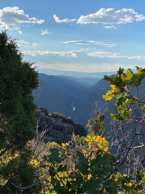
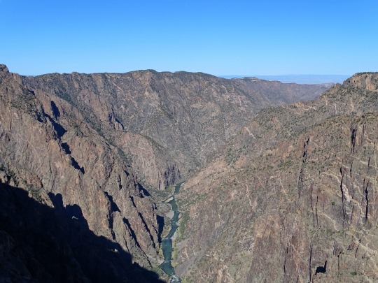
Sunset View Overlook at Black Canyon of the Gunnison National Park, Colorado, USA
My Photo ~ September 19, 2022
#black canyon of the gunnison#light#shadows#leaves#fall foliage#oak#autumn#juniper#canyons#gunnison river#view#vista#scenic overlook
62 notes
·
View notes
Text
#whatnot#original content#my photo#photography#black canyon of the gunnison national park#nps#colorado#rocky mountains#colorado plateau#gunnison river
2 notes
·
View notes
Video
Rediscovering the Magic of Nature! (Black Canyon of the Gunnison National Park) by Mark Stevens
Via Flickr:
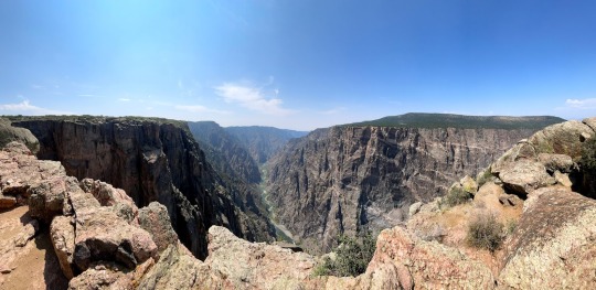
A view looking to the south across the canyon and gorge with blue skies above at the Kneeling Camel View overlook in Black Canyon of the Gunnison National Park. My thinking in composing this image was to angle my Nikon SLR camera slightly downward and capture that sweeping view with the Gunnison River slowly flowing by. The canyon and cliff walls would be all around with just a portion of the blue skies in the upper part of the image.
#Azimuth 181#Black Canyon#Black Canyon Of The Gunnison#Black Canyon of the Gunnison National Park#Blue Skies#Canyon#Canyon Walls#Colorado Great Sand Dunes & Black Canyon of the Gunnison#Day 4#DxO PhotoLab 3 Edited#Elk Range Area#Gunnison River#Kneeling Camel View#Landscape#Landscape - Scenery#Looking Down a Canyon#Looking South#Nature#Nikon D850#No People#North Rim#Outside#Portfolio#Project365#Ridge#Ridgeline#Ridges#River#River Canyon#River Gorge
2 notes
·
View notes
Text
Gunnison River Unleashed: Embark on a Waterside Odyssey
Discover the Majesty of Gunnison River
Welcome to the untamed realm of the Gunnison River, where nature’s grandeur merges with thrilling adventure. Nestled in the heart of Colorado, the Gunnison River invites adventurers to experience the exhilaration of its rapids, the serenity of its canyons, and the timeless beauty of its landscapes. Whether you’re seeking heart-pounding whitewater excitement…
View On WordPress
#accommodations#Adventure Travel#Camping#Colorado#destination guide#Gunnison River#Hiking#local culture#lodges#nature exploration#Outdoor Activities#rapids#River Rafting#rock climbing#water sports
0 notes
Text
Conservation groups filed objections this week to the U.S. Forest Service’s proposed final management plan for the Grand Mesa, Uncompahgre and Gunnison national forests in western Colorado. The plan would allow commercial logging on more than 772,000 acres of public lands, including mature and old-growth trees — a 66% increase from the current forest plan.
“A sizeable area of our beloved forests could be sacrificed to commercial logging at the expense of our already dwindling wilderness areas, wildlife habitat and recreation,” said Chad Reich with High Country Conservation Advocates. “Outdoor recreation is a far larger economic driver for our communities than the local timber industry that benefits from cutting these forests. The Forest Service would’ve known that if it had conducted an economic analysis, as required by law.”
Under the proposed plan mature and old-growth forests, which store massive amounts of carbon, could be commercially logged. Forest managers would not be required to identify and protect old-growth and mature trees. Steep slopes across the forests, including Upper Taylor Canyon and Slate River Valley, could also be logged despite the high risk of severe erosion and threats to water quality.
“The proposed plan directly violates federal policy on protecting mature and old-growth trees as a cornerstone of U.S. climate action,” said Alison Gallensky, conservation geographer with Rocky Mountain Wild. “The Grand Mesa, Uncompahgre and Gunnison national forests boast the highest carbon sequestration capacity of any national forest in the Rocky Mountain region. Despite this the Forest Service has failed to ensure these vital carbon sinks aren’t logged and sold.”
Objections also challenged the Forest Service’s failure to take urgently needed climate action by prohibiting new coal leasing in the plan.
...
The Forest Service recommended adding only 46,200 acres of new wilderness area in the final plan. The community’s conservation proposal had called for more than 324,000 acres of new wilderness lands. In addition, the Gunnison Public Lands Initiative offered a broadly supported proposal for new wilderness and special management areas in Gunnison County that was mostly excluded.
...
“Community members proposed special management area designations to protect pristine forestlands in the North Fork Valley from logging and oil and gas drilling,” said Peter Hart, legal director at Wilderness Workshop. “The Forest Service ignored those proposals and chose not to protect those areas in the new plan.”
The groups also raised concerns about the plan’s failure to address the myriad needs of plants and animals that depend on the forests.
“Over 20 years ago Colorado Parks and Wildlife reintroduced Canada lynx to the San Juan Mountains,” said Rocky Smith, a long-time forest management analyst. “This is a great source of pride for wildlife lovers in this state. Lynx are federally threatened and depend on mature forests with large trees. This plan allows for logging that could easily degrade or destroy much of the best habitat for lynx and their main prey, snowshoe hares, and undermine Colorado’s hard work to reestablish and maintain a viable lynx population.”
The Grand Mesa, Uncompahgre and Gunnison national forests also provide habitat for the iconic bighorn sheep and lesser-known species like the Grand Junction milkvetch and the Tundra buttercup. These species, among others, need special designation the Forest Service grants to plants and animals when there is concern about their ability to survive in the area. Many struggling plants and animals were left off the list in the proposed final plan.
“Without the species of conservation concern designation the Forest Service has no obligation to make sure the plants and animals continue to exist locally,” said Chris Krupp, public lands attorney with WildEarth Guardians. “In many cases, the agency decided not to designate wildlife, plants or fish merely because it had no data on their population trends. Without species of conservation concern designation, the number of bighorn sheep in GMUG could dwindle down to almost nothing and the agency wouldn’t have to do anything about it.”
#ecology#enviromentalism#old growth forest#colorado#us forest service#lynx#bighorn sheep#grand mesa#Uncompahgre#gunnison#national forest
496 notes
·
View notes

Text
National Parks progress
I haven't posted about this in awhile. I'm going to pass the halfway mark in May (they keep making it harder, though, four new National Parks have been added since I started this ten years ago).
Here's where I've been. I have a trip planned for May, those are in italics.
Cuyahoga Valley
Great Smoky Mountains
Mammoth Cave
Congaree
Grand Canyon
Petrified Forest
Big Bend
Guadalupe Mountains
Carlsbad Caverns
White Sands
Saguaro
Shenandoah
Acadia
Joshua Tree
Badlands
Wind Cave
Theodore Roosevelt
Hot Springs
Channel Islands
Biscayne
Everglades
Dry Tortugas
Glacier Bay
Wrangell St-Elias
Kenai Fjords
Denali
New River Gorge
Indiana Dunes
Voyageurs
Arches (May 2024)
Canyonlands (May 2024)
Capitol Reef (May 2024)
Mesa Verde (May 2024)
Black Canyon of the Gunnison (May 2024)
28 notes
·
View notes
Text

The eyes of people who have not slept and are not happy about it.
Well. It's been an eventful 48 hours. We were supposed to get into Denver Wednesday and head straight to Gunnison. However, our plane was delayed and didn't arrive in Denver until 10pm Wednesday night. Then we sat on the tarmac for 3 hours because the winter storm had all but a couple gates shut down. Then, the tram was down for an hour, which meant we were trapped in the terminal. We finally got to the baggage claim at 3am. And found out they couldn't get our bags off the train so we'd need to "come back tomorrow." Except we couldn't leave, because there were no ride-shares or taxis or rental cars available because of the storm. It was -12 (-25 with windchill) so walking somewhere wasn't an option. Our coats and cold-weather clothes were in our checked bags. And the hotel next door was full. At 10am (after maybe 2-3 hrs of restless sleep) we finally got our bags and our car and had breakfast at Rivers and Roads (10/10 do recommend, the barista gave us free gluten-free donut holes after hearing about our ordeal).
We got on the road at 11:30am, which is when the snowstorm hit. So the 3-hour drive took closer to 6. Here's a video toward the end when we finally drove out of the snowstorm and the sun came out, except the wind was blowing freshly fallen snow all over the road (lol @ B's little "you're doing great" at the end).
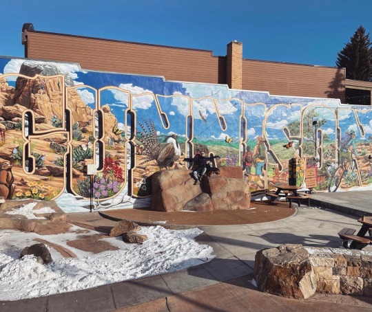
We finally got to Gunnison at 6 last night. Got frozen dinners to heat up in our motel microwave, took Deacon for a well-deserved walk (he has been the BIGGEST trooper through all this nonsense) and fell into bed by 9pm. We slept fantastically, woke up refreshed and feeling like new people today, and fully enjoyed visiting my old haunts in Gunnison (including stopping at Boom-A-Rang thrift for vintage snowsuits and Tributary Coffee for Tumeric/Ginger lattes).
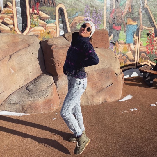

I was rocking my best 90's mom look and intend to continue doing so. We then hit the road for Montrose, and are now cozy in our hotel. We'll hike in the Black Canyon tomorrow morning and then head to Telluride :)
This has been a Winter Adventure Update.
(I'm planning to propose in Telluride. Probably. We'll see.)
152 notes
·
View notes
Text
For those that are curious, this is the Real World Horizon location map that Count uses, done by jesuscuervo on Reddit.
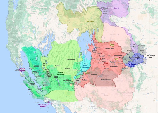
See under the cut for more information.
Real World Horizon Map (Speculative)
The Embrace proper is just the valleys and lakes between Pike’s Peak and Cheyenne Mountain, the core of the Nora Territory. Here, I placed each village in a valley respective to the location of Cheyenne Mountain but moved a few things around so it would not be too crowded.
The Outer Sacred Lands – outside the Embrace proper – contain several outcast camps. I had the Nora Territory expand across the Grand Mesa and Gunnison National Forest. Brom’s Camp is located over the Black Canyon of the Gunnison as it is depicted in-game, while Rost’s Hovel and Grata’s Camp are located on the hills/mountains closer to the Embrace.
Valleymeet; the neutral land between The Sacred Lands and the Carja Sundom is based on Maroon Bells, CO in-game. However, I mapped it out to include all of the White River National Forest within Valleymeet.
Hunter’s Gathering the main settlement in Valleymeet would likely be would be located on the Roaring Fork Valley near Woody Creek. That is the largest open valley in the area and the path through which the present-day CO-82 passes could work as a main throughway between the Nora and Carja lands.
Shivering Watch, following CO-82 the mountains narrow into a canyon south of Glenwood Springs (not Glenwood Canyon). The canyon acts as the chokepoint and border between the formerly Nora lands and the Carja Sundom where Shivering Watch and The Daytower are located.
Two Teeth Camp is depicted as being on Maroon Peak in-game. However, it is built over the ruins of the Smuggler-Union Hydroelectric Plant, which is further south in Telluride, CO. I kept Two-Teeth in the southern location so it acts as a second buffer between the Sacred Lands and the Sundom.
The Carja Sundom; is where the game took the greatest artistic liberty. The game depicts the heartland of the Carja Sundom south of the Colorado River (Lake Powell specifically); however the real-world locations depicted within The Sundom, the area its geography is based on (Eagle Canyon, Arches, and Canyonlands National Parks), and the route Alloy travels through suggests the Sundom is actually located north of the Colorado River in the real world. Thus rather than having the Sundom’s heartland located in the Colorado Mesa, it would make more sense to place it in the already fertile Price and Green River Valleys in Utah. This way I was able to keep Meridian in Eagle Canyon and Sunfall in Bryce Canyon. Thus Sunfall is actually southwest rather than northwest of Meridian. The Carja Sundom would extend across most of the Western Slope in Colorado into most of eastern and southern Utah. With Shatter Kiln (Provo) as its northernmost boundary.
The Sun-Steps – are the first region of the Sundom that Alloy encounters on her journey. In-game it stretches from Arches National Park to what appears to be Horseshoe Bend. However, Horseshoe Bend is too far south for it to make sense as the border, so I have Morning Watch located further north on another bend. Since river bends can form anywhere it is not a stretch to think there is a new bend somewhere else. Over all the Sun-Steps correspond to the Grand Valley in CO.
Free Heap – located within the Sun Steps is Free Heap, an Oseram outpost set up to provide construction material for Meridian. If they are mining for industrial materials from the Old Ones, it would make the most sense for Free Heap to be located on or near Grand Junction CO, which is the largest settlement in the area today.
Gatelands – form the eastern half of the central Carja Sundom. Unlike the rest of the Sundom, this region is relatively easy to map out since most locations have an obvious real-world reference corresponding to Arches and Canyonlands National Parks.
Lone Light had to be relocated since Horseshoe Bend is much further downriver in reality. I placed it in a smaller bend upriver.
Gatelands Bandit Camp - I depicted the Bandint Camps as neutral/independent enclaves within the Sundom, the Gatelands Camp being the largest one of these and corresponding to the entirety of Arches National Park.
The Jewel – the central heartland of the Carja Sundom appears to be based on Monument Valley in present-day Utah and Arizona. However this location would be rather out of the way from Aloy’s journey and it doesn’t fit some of the locations depicted within the Jewel itself (mainly Meridian, which is located in Eagle Canyon). Thus, I thought it made more sense for it to be centered on the eastern Green River Basin along the present-day Carbon, Emery, and Wayne counties. This way Meridian remains in Eagle Canyon and the Spurflints in the San Rafael Reef. The Spearshafts would be a new formation (not present today) somewhere in Canyonlands National Park.
Rustwatch – in-game the Shadow Carja territory is north of the Jewel across from Daybrink (Lake Powell), however since The Jewel is no longer located south of the Lake, Rustwatch and Sunfall are now southeast of the Carja heartland. But Sunfall keeps its location in Bryce Canyon.
The Southern Frontier – in-game Kestrel’s Perch is defined as a fortress built by the fifth Sun King Zavarad as the Sundom expanded north of Daybrink (Lake Powell) into Rustwatch. However because in the real world, Lake Powell is south of what I’ve defined as the Carja heartland, this frontier is now south of Daybrink and Rustwatch.
The Mountain Frontier – Call of the Mountain doesn’t really give many references on where Rising Light and the main route of the game are located, except that it is mountainous and – for the most part – densely wooded. So I opted for the Sundom to have a “Mountain Frontier” along the Wasatch Range. Because the world of Horizon is likely set in a warmer and wetter Earth (due to rising sea levels), the Bonneville and Lahontan Great Lakes have been resurrected east of this range. The former of these acts as The Sundom’s western border and provides the precipitation and rainfall necessary to create forests and jungles in the Colorado Plateau.
Shattered Kiln – a bandit camp near the northern reaches of the Sundom, as in-game it is based on Provo Utah near Maker’s End (Salt Lake City).
The Daunt; the southwestern corner of the Carja Sundom corresponds to Zion National Park. However, Zion is relatively small to fit all the in-game locations. In-game, Zion National Park appears to be the same size as the entirety of Southern Nevada or the California Central Valley. To fit everything in, I extended The Daunt to include the entire Virgin River Basin in Washington County Utah.
Barren Light would then be located with St George, Utah where the Virgin River (and the I-15) cross Bloomington Hills.
Chainscrape and the Redhew Quarry, the Oseram settlement within the Daunt is located along a bit upriver from Barren Light.
The Claim; the Oseram territory is not depicted in-game, however, Pitch Cliff and Free Heap are two Oseram settlements near their border with the Carja Sundom. It is stated that their territory is north of The Sundom and west of The Cut, so it likely corresponds to Idaho, specifically the Snake River Basin.
Pitch Cliff is likely located along the Roan Cliffs, and possibly very near the border between the Claim and the Sundom.
The lands between The Long Roam, the Claim, and the Carja Sundom form an unclaimed region around the present-day Uintah Basin. Oseram traders travel through it and the Carja might have sent some raiders across it, but it remains mostly unpopulated. I shaded this area pink as the Carja might claim it but likely hold no direct control.
No Man’s Land - is the border between the Carja Sundom and the Tenakth Clanlands. No Man’s Land borders are not well defined in-game, but they seem to correspond to the northern shore of Lake Mead, specifically the area around the Overton Arm where the Virgin River meets the Lake. The overall location works for a real-world equivalent, but a few things get shuffled around for them to fit.
Jagged Deep; the eastern bank of the Virgin River was tenuously controlled by the Carja Sundom. What remains is Riverwatch, an abandoned fort on the banks of the Overton Arm, and Jagged Deep an abandoned mine that is now delved by Oseram adventurers. The Carja Camp on the west bank of the Overton Arm is the furthest west Carja settlement.
Eastern Lie & Deadfalls are the westernmost Tenakth settlements closest to the Cajra and Utaru borders, which have been taken by Regalla’s Rebels. In fact, most of the Tenakth side of No Man’s Land is occupied by the rebels.
Spinebreak; in-game Spinebreak is located on the southeastern border between No-Man’s Land and the Tenakth Clanlands proper and built under the ruins of a present-day highway tunnel. The issue is that there are no tunnels – or logical places to put a tunnel – between the Overton Arm and Las Vegas (the Stillsands). I thus place Spinebreak further north on the Virgin River Canyon acting as a second border between Barren Light and the Tenakth camps.
The Utaru Tribal Lands; the Utaru settled in the lands surrounding the Western Grand Array (WGA), which they named Plainsong.
Plainsong, although the WGA is based on the Very Large Array in New Mexico, the VLA is very far from Aloy’s path and the in-game geography. Furthermore just like the Nora take their name from the NORAD Facility and the Tenakth take their name from the Tenth Task Force, I suspect the Utaru take their name from Utah. Thus it is likely that the WGA is not the VLA but rather a new array built somewhere in Southern Utah, between the Carja Sundom and the Desert Clans. With this in mind, I placed Plainsong on the Cedar Valley and worked from there.
Stone’s Echo – Stone’s Echo is an Utaru outpost near the Stillsands, just past No Man’s Land. I placed it along the Meadow Valley Wash, which would likely be a tad more fertile than in the present day. Because we are dealing with what I expect is a warmer and wetter climate due to rising sea levels (and AETHER’s supercell storms going haywire).
Riverhymn – On the northern edge of the Utaru lands lies Riverhymn; the second largest Utaru settlement after Plainsong. In-game it is located in a fairly mountainous corner. So it is likely located near Frisco Peak with the river that passes through it being the Beaver River. However this river flows in the opposite direction that is seen in-game, rather than flowing south towards Plainsong, it flows north into the Sevier Lake.
·Due to the wetter climate, it is possible that the entire Bonneville Basin is once again flooded and Lake Bonneville acts as a boundary between the Utaru, the Carja, the Oseram, and Tenakth Desert Clans but the game map does not go that far north. Regardless I thought it be cool so I opted to depict it as such.
Tenakth Desert Clans; the Desert Clans inhabit most of Southern Nevada. Their territory reaches the present-day Great Basin National Park in the northeast and the Shining Wastes (Death Valley National Park) to the West.
The Stillsands; southwest of the Utaru territory, is another semi-contested region (it is within the Tenakth Desert Clan territory but both major settlement Camp Nowhere and Hidden Ember are Oseram). This is pretty simple since it corresponds to Clark County NV, with Hidden Ember clearly being Las Vegas. I originally had Devil’s Grasp be located in Barstow CA, but opted to place it closer to Las Vegas in Primm.
Dry Yearn; is the easternmost region of the Clanlands. It contains Arrowhand, the second largest Desert Clan settlement, and Restless Weald. It is fairly easy to place since Restless Weald is based in Caliente, NV. With this in mind, I placed Arrowhand over Crystal Springs, NV, and the Dry Yearn Camp just north of Restless Weald.
The Greenswell; is the northernmost region of the Desert Clanlands; it is also the least arid region of the Desert Clans. Part of this can be attributed to the supercell storms, but I also opted to have the core of the territory within the Great Basin National Park, which is a very green area within the Nevada desert, which further explains the area’s climate.
Scalding Spear; centrally located in the Nevada desert, the capital of the Desert Clans is located on the present-day Crescent Dunes Solar Energy Project.
Shining Wastes; is an arid mostly flat expanse of land, which for the most part corresponds to Death Valley National Park. The only problem is that Death Valley is not particularly flat. I included Death Valley, now filled in with a saline lake, within the Shining Wastes but placed the main settlements located further north within the Nevada Desert (which is mostly flat).
Runner’s Wild – a small region in the Desert Clan territory, Runner’s Wild corresponds to Mammoth Lakes in California and acts as a border between the Desert and Sky Clans.
Salt Bite – north of Runner’s Wild this region borders Runner’s Wild and the Greenswell, it is clearly based on Mono Lake in California and the geography easily fits into this location.
Memorial Grove; although the Tenakth are divided into three warring Clans (and Regalla’s Rebels), the Memorial Grove acts as a capital / neutral ground for all three. The Grove is located on a museum and military base – specifically an airforce base – south of Mono Lake. The base does not exist in the present day but could be located anywhere in the Owens Valley. I paced it on Independence, CA (fitting name). Like other areas on the map, the Owens Valley is also much more fertile than in the current day.
Tenakth Sky Clans; northwest of the Memorial Grove the Sky Clans make their home along the Sierra Nevada, specifically Yosemite Valley and the Sierra National Forrest. Not many changes here, but it doesn’t seem like their territory expands much further north than Lake Tahoe (unless it is not depicted).
The Bulwark; the capital of the Skyclans is based on Sentinel Dome in Yosemite Valley, I kept it here and based the rest around it.
Sheerside Mountains; are based on the Sierra Nevada, the region itself corresponds to the northern half of the Sky Clans’ territory. I took Sheerside Climb to be the pass from Mammoth Lakes to Yosemite and assumed Bonewhite Tear and the other settlements would be located along CA Route 120 and the Tuolumne River.
Stand of the Sentinels the southern region of the Sky Clans appears to be based off the Sierra National Forest. Its major settlements follow a pass from Mammoth Lakes to Tide’s Reach (possibly Fresno CA, see below). This suggests that the major settlements are located along the San Joaquin River.
Tenakth Lowland Clans; like the Carja Sundom, the Lowland Clans pose a huge conundrum. The Lowlands seem to consist of the foothills of the Sierras along Kings Canyon National Park and the Sequoia National Forrest towards a coast. This suggests that California’s Central Valley is flooded due to rising sea levels. If this is the case it helps explain why The Long Coast (Bakersfield) is a coast and not inland.However, if this were the case there should be a long peninsula formed from California's Coastal Ranges. But this peninsula is completely absent from the in-game map. Furthermore, Tide’s Reach appears to be based in Oakland, but it is geographically located at the foothills of the Sierra National Forrest. This should be impossible; Oakland would be located on the aforementioned “peninsula” between San Francisco Bay and the “Central Valley Sea”, but this peninsula is nowhere to be found on the map.
I tried my best to come up with a creative solution.
Raintrace – as in-game Raintrace is based on Sequoia National Forrest, Lowland Path and Fall’s Edge are located along CA Route 180 and King’s Canyon, which provide a direct route from the Memorial Grove to the rest of the Lowland Clans’ territory. Fenrise is further south on Isabella Lake where the Kern River valley provides a connection between the Desert Clans and Lowland Clans’ territories.
Tide Reach – I relocated Tide’s Reach to Fresno, CA which is now along the coast of the “Central Valley Sea”. I opted to have it based on Fresno since it provides another large present-day settlement where to base it, and more importantly, it is directly on the path Alloy would take from Stand of the Sentinels. Since Alloy can’t swim from Tide’s Reach to the Isle of Spires (San Francisco) it makes sense to place it further away from the island than Oakland. SF Bay is large, but not large enough for there to be a storm that wrecks Alloy’s raft. To make the route Alloy takes a bit more logical I also broke up the Coastal Ranges north of the Salinas River into an archipelago. I considered sinking the entirety of the Mt Diablo Range, to provide a direct route from Tide’s Reach to the Island, but I thought that would be too much.
The Long Coast – in-game The Long Coast seems to refer to the Pacific Coast, but as already mentioned it also refers to the ruins of Bakersfield CA. Thankfully a flooded Central Valley means we’ve gained a new coast. Thus the Long Coast now refers to the western coast of this inland sea. Thornmash, in-game coordinates suggest it is located near Tracy, CA. but I placed it a little further south on this coast so it forms a triangle with Tide’s Rach and Raintrace Rise and so it is not too close to San Francisco.
Cliffs of the Cry – as in-game the Cliffs correspond to Big Sur and the California Pacific Coast. I opted to have Raintrace West located on the Cliffs (close to San Luis Obispo) since you travel from it to the Zennith Base.
Isle of Spires; is straightforward San Francisco, which is now an island. Alva describes San Francisco as an archipelago, so this helped me further justify the breakup of the Coastal Ranges. Although I realize that such geologic shifts would likely destroy the city of San Francisco itself. This is the suspension of disbelief in a world that has a volcano appear on Yellowstone and New Zealand sink beneath the waves.
Zenith Base; originally I thought about having it located in Monterey however it is south of Tilda’s Mansion, which is in Big Sur. It then seemed fitting to place the Zenith Base in Vandenberg Airforce Base instead.
The Burning Shores; it is LA, which like San Francisco is now an archipelago due to tectonic activity and rising sea levels. This is pretty much explained in-game.
Fleet’s End is located somewhere in the Baldwin Hills, which are now the main island of the “bay”
Pangea Park / Londra Productions is described as being on a peninsula. Because it is partially based on Dinseyland (or Universal Studios) I’ve opted to keep it in Anaheim. To make Anaheim a peninsula I’ve flooded the San Gabriel Valley in the north and Newport Beach in the south.
#aloy and seyka#aloy x seyka#horizon burning shores#horizon forbidden west#countdown#my writing#countdownfic#horizoncountdown#field guide
19 notes
·
View notes
Photo
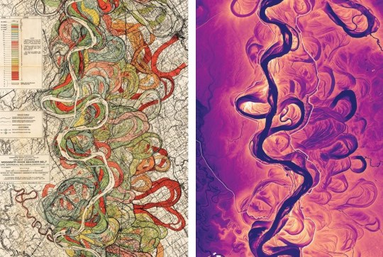
Left: A 1944 map by geologist Harold Fisk charts a 40-mile stretch of the Mississippi River from Friars Point to Gunnison, Mississippi. Fisk used aerial photos and maps to estimate the past and then-present channels. Right: By comparison, a map created using lidar shows shifts over the past 75 years. Erosion and changes in flow caused the channel to widen in the middle of the image and migrate toward the south.
Source; https://www.nationalgeographic.com/.../mississippi.../
[Geomorphological Features]
* * * *
“My vessel is launched on the boundless main and my sails are spread to the wind ! In the whole of the world there is nothing that stays unchanged. All is in flux. Any shape that is formed is constantly shifting.
Time itself flows steadily by in perpetual motion. Think of a river: no river can ever arrest its current, nor can the fleeting hour. But as water is forced downstream
by the water behind it and presses no less on the water ahead, so time is in constant flight and pursuit, continually new. The present turns into the past and the future replaces the present; every moment that passes is new and eternally changing.”
― Ovid, Metamorphoses
120 notes
·
View notes
Text
Black Canyon of the Gunnison National Park, Colorado
Explore:
#black canyon of the gunnison#national park#national park service#travel#nature#nature photography#canyon#original photography#photographers on tumblr#photography#lensblr#landscape#landscape photography#colorado#wanderingjana
8 notes
·
View notes
Text


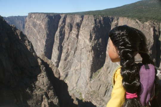
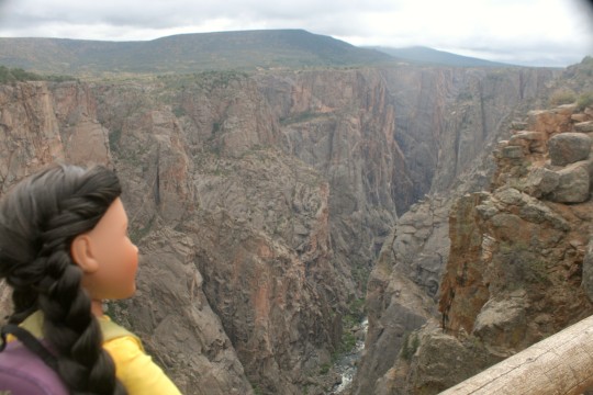

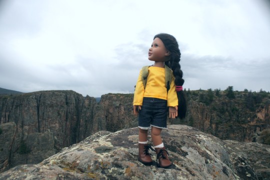


Kewanee and I spent the past few days exploring Black Canyon of the Gunnison National Park, in western Colorado. As you can see, we had a great time! The canyon itself is breathtaking--in some places it's 2000 feet/600 meters deep! The ancient, exposed rock tells the life story of Earth over many millions of years. The Gunnison river flowing through the canyon down below seemed so far away, even though we could hear its roaring in the distance.
Kewanee is such a fun little buddy to bring along on outdoor adventures. She's always down for anything, and never gets tired or bored.
The best views were from the south rim, although the solitude of the north rim was nice. Our campsite was lovely as well, so much so that it was especially sad to leave it when our trip was over.
14 notes
·
View notes
Video
I’ve Seen Black Canyon of the Gunnison Up Close by Mark Stevens
Via Flickr:
Now I’ve seen it from up high :-) This was on an airplane flight from Salt Lake City to Austin after spending about a week in southern Utah and Nevada exploring national park there. I had a chance to visit Black Canyon of the Gunnison National Park not long after the start of the Covid pandemic and was amazed at the wonder and geology of that area with its formations. I found this view a touching way to end a trip on my flight back to Austin. I wasn't able to get any GPS locations, but the view is looking generally to the southwest while over the western center portion of Colorado.
#Aerial View#Airplane Window#Airplane Window View#Airplane Wing#Azimuth#Black Canyon#Black Canyon Of The Gunnison#Black Canyon of the Gunnison National Park#Blue Skies#Canyon#Canyon Walls#Day 9#Delta Airlines#DxO PhotoLab 5 Edited#Elk Range Area#Flight SLC to AUS#Flying over Colorado#Gunnison River#Jet Airplane#Landscape#Landscape - Scenery#Looking Down a Canyon#Looking Outside Plane Window#Looking SW#Looking out Airplane Window#Looking out the Airplane Window#Miscellaneous#Nikon D850#No People#North Rim
0 notes
Photo
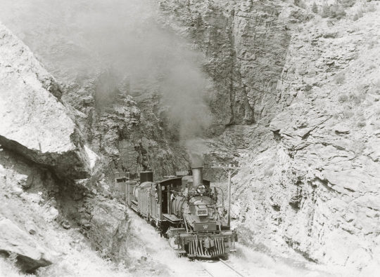
Black Canyon of the Gunnison
In the northwest portion of the “Narrow Gauge Circle,” Denver & Rio Grande Western 2-8-0 narrow-gauge steam locomotive No. 361 leads a freight out of the Black Canyon of the Gunnison River near Cimarron, Colorado, on June 29, 1939.
R. H. Kindig
14 notes
·
View notes
Text
Rezension -So weit der Fluss uns trägt-

Klappentext
Am Fuße der Berge Colorados strömt der Gunnison River an einer alten Pfirsichfarm vorbei. Hier lebt in den 1940ern die 17-jährige Victoria mit ihrem Vater und ihrem Bruder in rauer Abgeschiedenheit. Doch der Tag, an dem sie dem freiheitsliebenden Wil begegnet, verändert alles. Bald ist Victoria gezwungen, das Leben, das sie kennt, aufzugeben und in die Wildnis zu fliehen. Dort muss sie ums Überleben kämpfen - um ihr eigenes und um das ihres ungeborenen Kindes. Als sie endlich die Kraft findet, neu anzufangen, droht der Fluss, alles zu zerstören, was ihrer Familie seit Generationen ein Zuhause war.
Cover
Das Cover hat mich sofort angesprochen, es passt perfekt zum Buch.
Schreibstil
Der Schreibstil ist packend und hat mich direkt in die Geschichte hineingezogen.
Inhalt/Rezension
Ich bin durch die allgemein positiven Meinungen auf das Buch aufmerksam geworden und ich mit einer tiefen und schweren Geschichte gerechnet, das sich auch bestätigt hat.
Victoria wächst auf einer Pfirsichfarm auf und muss schon früh mit einigen Todesfällen leben. Als sie sich in Wilson verliebt, muss sie fliehen und in der Wildnis überleben.
Ich habe die Protagonistin sehr bewundert, sie ist stark und gibt niemals auf. Auch die schöne Landschaft von Colorado wird toll beschrieben und man hat das Gefühl mit Victoria gemeinsam in der Wildnis zu sein.
Das Buch hat mich sehr berührt, das Leben der jungen Frau und wie sie damit umgeht und lebt hat mich sehr inspiriert.
Fazit
Ein Buch, das noch länger in mir nachhallen wird.
Zum Buch
Verlag: C.Bertelsmann
Autorin: Shelley Read
Preis: 24 Euro
Buchlänge: 366 Seiten
2 notes
·
View notes
Text

Gunnison river in Black Canyon of the Gunnison National Park in Colorado, USA
53 notes
·
View notes
Last Seen Blogs

piceleyi
Untitled

lyriquediscorde-all-things-music
Lyriquediscorde

yourmothersson
Your Aunt’s Sister’s Kid

cilantlis
magic man

cinnamonbunpuff
nothing but slay