#field guide
Explore tagged Tumblr posts
Visit Tumblr Blog
Explore Tumblr blogs with no restrictions, modern design and the best experience.
Last Seen Tumblr Blogs


Fun Fact
Tumblr was named as a finalist in Lead411’s New York City Hot 125 in Aug 2010.
Text
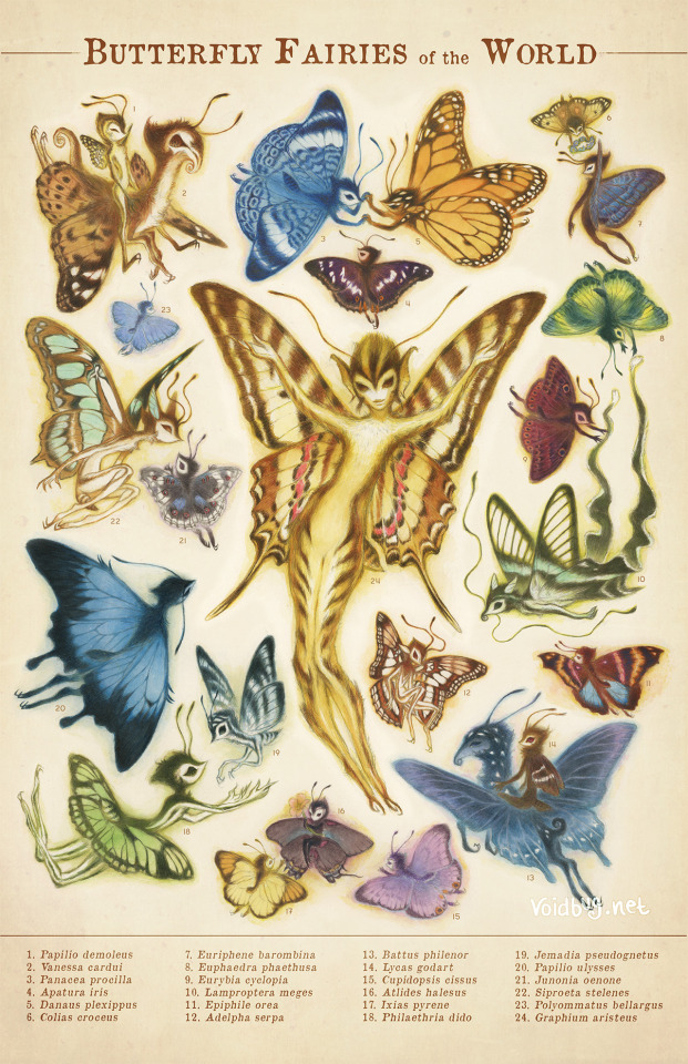
🦋BUTTERFLY FAIRIES OF THE WORLD🦋 I think at this point I've posted all of my butterfly fairies! I've been working on this thing forever, so I really hope you enjoy it. It's very much a love letter to scientific illustrations of animals, that I used to pour over as a kid! I made prints of this illustration as well, which you can buy on my etsy!
#fairy#retro#vintage poster#scientific illustration#fantasy art#field guide#watercolor#faeries#faerie#fae folk
5K notes
·
View notes
Text
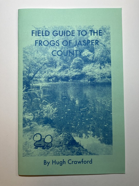


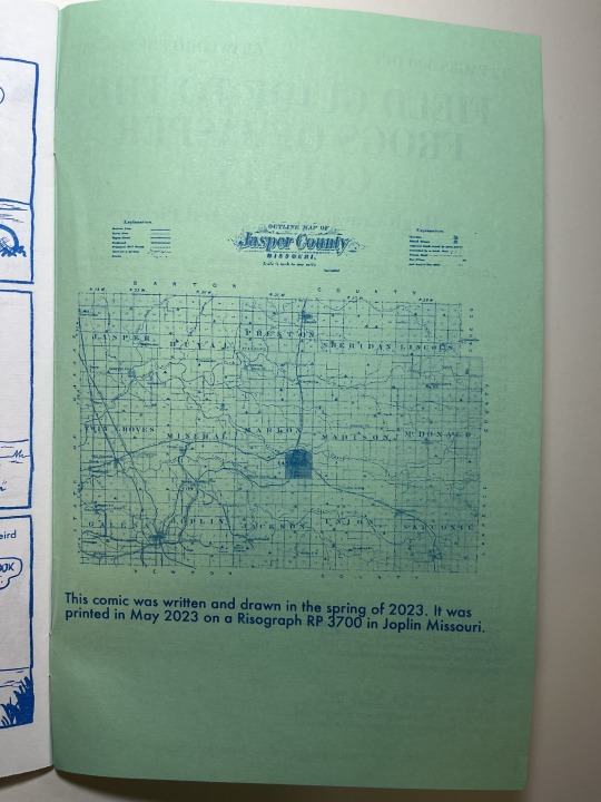
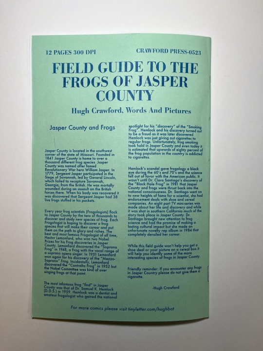
FIELD GUIDE TO THE FROGS OF JAPER COUNTY
This is a collection of single page gag comics about frogs in the form of a field guide. Released in the spring of 2023. 12 pages. 5.5 X 8.5 in. Blue ink on green copy paper cover. Blue ink on white copy paper for the interior pages. Risograph printed.
#risograph#frogs#comics#comic#frog#field guide#field guide to the frogs of jasper county#comic zine#zine#mini comic
977 notes
·
View notes
Text

A new style of reference sheet, reminiscent of a field guide. Featuring one of my favorite birds!
107 notes
·
View notes
Text
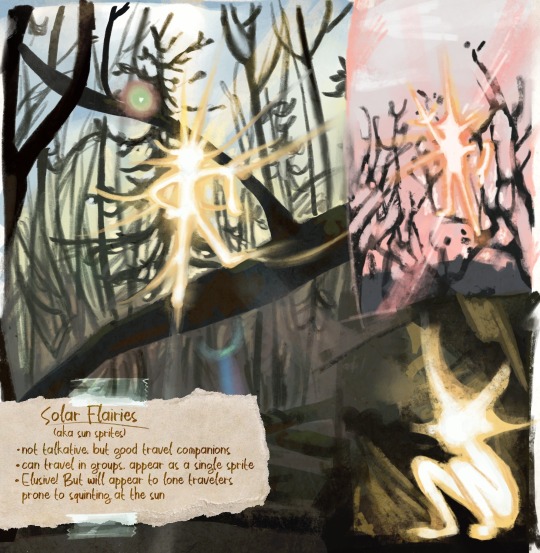
I’ve always wanted to make a fantasy field guide because my brain chemistry was permanently altered by the kids’ media landscape of the early 2000s. I’ve also really needed to sort of get back to what I love about art lately. So, here’s a little sampler of some… field paintings I did today of some very real subjects.
#my art#kids lit art#fantasy art#fairies#fantasy character#creature design#fantasy illustration#digital art#art#illustration#fantasy#children’s book illustration#children’s media#plein air#nature illustration#outdoors#woods#wilderness#hiking#field guide
574 notes
·
View notes
Text

I have THE biggest, BEST news EVER--
I GOT A BOOK CONTRACT!!!!!!!!
I am exceptionally pleased to announce that I have just signed a contract with Ten Speed Press (a division of Penguin Random House) to publish...
The Everyday Naturalist: How to Identify Animals, Plants, and Fungi Wherever You Go!
It is slated for publication in early Summer 2025, and will be written for anyone who wants to be able to identify the living beings around them regardless of educational level or experience. A HUGE thank you to my literary agent Jane Dystel of Dystel, Goderich & Bourret LLC, and my editor at Ten Speed Press, Julie Bennett!
This isn't just another field guide--it's a how-to book on nature identification that helps you go from "I have no idea what this animal/plant/fungus is and I don't know where to start" to "Aha! I know how to figure out what species I'm looking at/hearing!" Those familiar with my nature ID classes know that I emphasize skills and tools accessible to everyday people. Whether you're birdwatching, foraging, or just enjoying the nature around you, my goal is to help you be more confident in figuring out what living beings you encounter wherever you go--and not just in the Pacific Northwest.
The Everyday Naturalist will not only explain what traits you need to pay attention to like color, size, shape, location, etc. and how to use them to differentiate among similar species, but will also detail how and when to use tools like apps, field guides, and more. (And given the current kerfuffle about A I generated foraging books, I will of course include information on how to determine the veracity of a given book or other resource.) And my editor and I have already been discussing some great additions to the book that will make it even more user-friendly!
Are you excited about this? I certainly am! I wanted to wait until the pixels were dry on the contract before going public with this (though my newsletter subscribers got to hear about it last month, lucky them!) It still doesn't feel real, but I'm already working on the manuscript so it'll sink in soon enough.
I will, of course, keep you all apprised of my progress because this project is going to be a big part of my life over the next several months as I write and edit and write and edit and wash, rinse, repeat. So keep your eyes on this space for updates (and feel free to add yourself to my monthly email newsletter here, too!)
#nature#nature identification#animals#plants#fungi#field guide#mushrooms#foraging#birding#birdwatching#scicomm#science communication#books#nonfiction books#publishing#wildlife#science#biology#botany#mycology
989 notes
·
View notes
Text


look for the name NOVEMBER (requested by @clownov) | jody t of california black corduroy and red plaid long-sleeved maxi dress (c. 197o's), london underground black leather wooden heel and platform boots, laura benson "temptation" earrings, fort & manlé "late harvest" eau de parfum (cherry tobacco, rosewood, cedarwood, leather, rose, vanilla), a fifth edition of mrs. william starr dana's "how to know the wild flowers: a guide to the names, haunts and habits of our common wildflower" (1894 edition)
#november#nov#name#request#outfit#clownov#hope you like !#gunne sax#vintage#plaid#corduroy#autumn#boots#london underground#footwear#book#field guide#flora#edp#perfume#earrings#jewellry#laura benson#fort & manle#queue
120 notes
·
View notes
Text
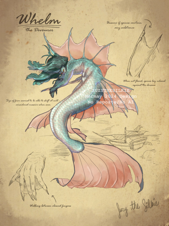
Mermay day one, hopefully I can keep it up for 31 day.
#my art#fantasy#merfolk#creature design#character design#mermay#mermay 2024#mermaid#merperson#sirencore#field guide#sketch#art#artists on tumblr#illustration
172 notes
·
View notes
Text
Beta’s Zenith Huntress outfit

Artwork © system-threat-detected on Tumblr.
Concept is from missmrah’s artwork.
#horizon burning shores#horizon forbidden west#countdown#my writing#horizoncountdown#countdownfic#field guide#aloy & beta#aloy x seyka#aloy and seyka
72 notes
·
View notes
Text
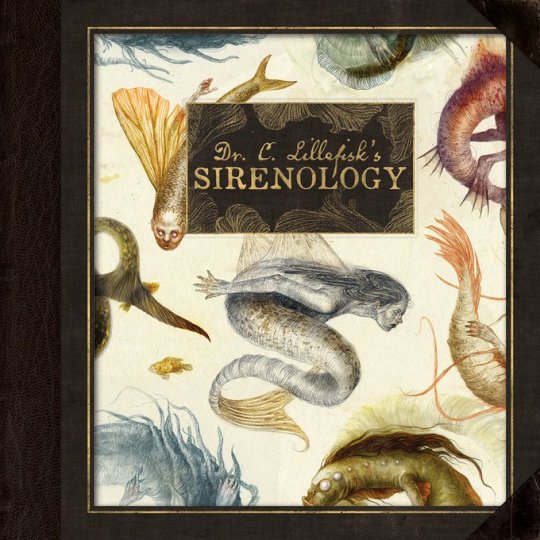
I just noticed I didn't tell you yet--which is shameful as it is Tumblr where the Mermaid Scientist was born! My Mermaid Book was picked up by Eye of Newt and is available for pre-order right now (it's coming out very soon, though, so any orders should make it until Christmas if that's a concern of yours)! If you're in North America, I'd suggest ordering directly through my publisher's website, however it's available anywhere you'd usually order books. You can ask your favourite indie book shop to order it for you or--if there's no other option or you're worried about crazy shipping costs where you live--it's available via the place starting with A, which shall otherwise not be named, as well. Please note: This is an edited version of the original book. It's shorter, but with more coherent world building and a beautiful new layout and design. It's a proper field guide now!
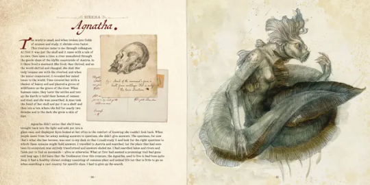
#Mermaid book#books#mermaids#field guide#art book#this makes me a traditionally published author-illustrator now :DDD#when we talked about editing the book for publication my publisher was like#we love Dr Lillefisk#Let's keep her!#Now she's in the title!#I made her up on a whim!#Her name is just grammatically incorrect Swedish#I love it so much#just thinking about how everything started and came together#and the book changed and grew and now#7 years later this is where we are!#my publisher send me the video btw#I can't wait to get the book myself!!
231 notes
·
View notes
Text
not trying to turn this into a warrior cats blog but i have to say, one of my favourite pieces of warrior cats media has to be the Cats of the Clans Field Guide.
Genuinely, this field guide acknowledges some of the biggest gripes I've had with the warrior cat series (and through the perspective of Rock !!).
Also, it's just super well written (imo, at least) and the art is gorgeous ????? The idea of the reader being in the perspective of 3 starclan kits talking to Rock is actually so peak.
Of course, we have the usual continuity errors that appears in almost every book post-TPB, and some stuff did not age well lorewise, but i don't think the writing team ever really thinks that far ahead for the lore to be properly coherent anyways.
I'm just going to share a few of my favourite things about this book, though i do recommend reading it yourselves.
Warning: Massive wall of text below
- Rock being unbiased towards any clan. One of the few books where I didn't feel like it was leaning towards one clan more than the other. Having each clan be represented by the 3 straclan kits (mosskit for river/thunder, blossomkit for shadow, adderkit for wind) is such a smart move. Any biases are portrayed through the kits themselves.
- Rock has these moments where he openly criticises the clans for the way they tend to consider themselves better than non-clan cats. He says that there have been better cats to exist who were never involved with clan life. It was honestly so refreshing to see this weird supremacy stuff get acknowledged.
- Rock also acknowledges that starclan is flawed. Throughout the book he wonders whether they have biases and mentions how strange it is that shadowclan keeps getting messed up by starclan (e.g. the nightstar situation). He also mentions how faith in starclan isn't everything.
ALSO ALSO, quote from the book: 'For once I believe Starclan has acted in every Cat's best interest'
"FOR ONCE",, I love Rock.
My only wish is that leafpool getting doomed by starclan (and the narrative) could've been acknowledged. However, this book was pre-OOTS perspective, so leafpool had not yet reached fully doomed status.
- Rock wonders whether tigerstar ever looks at hawkfrost and remember his persecution of halfclan cats (this drove me insane while reading TNP i am so glad it has been pointed out here)
- Something that stood out to me so, so much as well is the way Rock points out, and criticises how overlooked Sandstorm is and how she tends to be reduced to simply being the mother of Firestar's kits. Rock is a no. 1 sandstorm fan, and i agree with him.
- Rock's disdain of spottedleaf being in Firestar's business is so true. Thank you Rock for speaking on what the authors would later forget.
- Rock calls Tallstar's last-minute deputy change foolish. Tallstar is one of my favourite characters, but even I have to agree with this.
- PRINCESS SITS ON THE FENCE AND STILL WONDERS TO THIS DAY WHETHER HER KIN ARE SAFE
Genuinely, what ?? Did the Erin Hunter team actually just decide to sit down that day and properly (kinda) consider all the flaws of the characters they created.
idc what anyone says, i consider majority of what this field guide says to be canon LOL
#pocket_tortilla#i needed to get this out of my system#rambles#living in my head rent free#warrior cats#erin hunter warriors#riverclan#shadowclan#skyclan#thunderclan#windclan#crowfeather#field guide#warriors#wc#wc oots#wc tnp#wc tpb#wc po3#po3#oots#tpb#tnp#starclan#leafpool#spottedleaf#sandstorm#warrior cat spoilers
31 notes
·
View notes

Text


Some days, I choose to be an adventurer.
62 notes
·
View notes
Text
A new book on the importance of community science
A woman in Chicago became an expert on the birds and insects living in her rooftop garden and formed an urban rewilding club after reading Rewilding Our Hearts: Building Pathways of Compassion and Coexistence.
I was thrilled to learn of Dr. Menno Schilthuizen's new book The Urban Naturalist: How to Make the City Your Scientific Playground. Here's what he had to say about his most timely book.
#solarpunk#solar punk#community#biodiversity#wildlife#field guide#urban nature#citizen science#community science#how to#book review
10 notes
·
View notes
Text
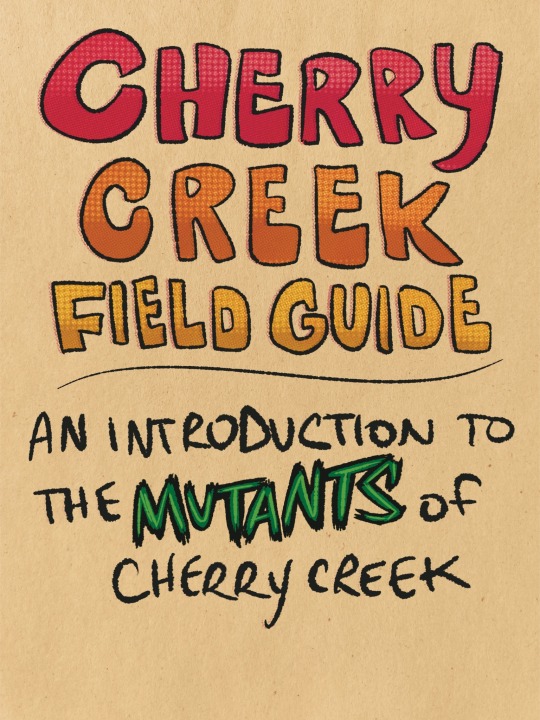
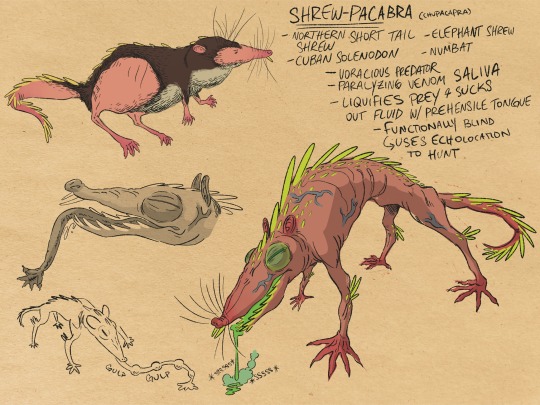
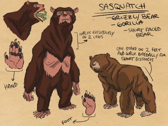
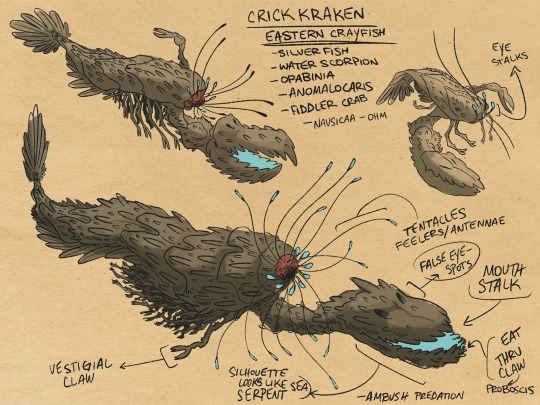
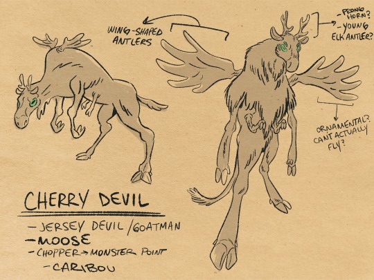
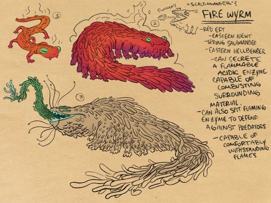
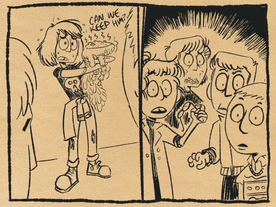
Mutants of Cherry Creek (pt 2)
Some MORE mutated critters from my YA lovecraftian horror comic set in 90s New England.
Mutagenic ooze is seeping into the town of Cherry Creek and mutating normal New England wildlife into terrifying monsters. The Cherry Creek Middle School Paranormal Investigation Club sets out to discover, catalogue, and tame all of the mutated cryptids and hopefully find the source of the toxic ooze before it permanently infects everything (and everyone) in town.
Northern Short Tailed Shrew — one of only a few venomous mammals
Brown and Black Bears - walk on two legs, climb trees, intelligent
Eastern Crayfish - present in the fossil record for at least 300 million years Eastern
Moose - huge but stealthy
Eastern Newt (Red Eft) — can secrete a strong smelling chemical from glands in its skin
At first, the animals just seem weird, strange, a little “off”. Over time, exposure to the ooze causes these creatures to get bigger, meaner, and much more dangerous. (all the beginning stage creatures shown here are newly mutated, their final stages are after only a few weeks of exposure)
I also love folklore and cryptids and I really love the idea of this club of dorky middle school cryptid hunters assigning names like “bigfoot”, “mothman”, and “hodag” to these monsters so can try and contextualize something they don’t really understand. Soon the club realizes these aren’t fun isolated critters but symptoms much larger impending ecological disaster!
I picture it like pokemon evolution, going from a cute water turtle to a kaiju which is a lot for a ten year old to handle.
Which is your favorite? What cryptid would you wanna see? What animal should I “Cryptify” next? lmk what you think!
#artists on tumblr#digital art#illustration#illustrator#character drawing#illustrated book#character concept#character illustration#fantasy art#children’s illustration#ya horror#horror for kids#lovecraft#eldritch#indie comics#fauna#bestiary#field guide#kaiju monster#monster art#creature design#character art#lovecraftian#middle grade comics#horror comics#sci fi comics#campy scifi#cryptidcore#cryptid#paranormal
40 notes
·
View notes
Text

from the deep #24023: blue jay illustrations by Arthur Singer for A Guide to Field Identification: Birds of North America by Chandler S. Robbins, Bertel Bruun, and Herbert S. Zim.
#blue jays#corvids#corvidae#birds#illustrations#field guide#pinyon jay#gray breasted jay#scrub jay#steller's jay#i went the the library :)#from the deep no. 24023
38 notes
·
View notes
Text

Some creature concepts I’m working on, loosely inspired by the ark survival evolved dossiers! Still have lots to do but here’s a little bit of what I have so far :)
#artists on tumblr#digital art#digital illustration#art#colorful#fantasy#fantasy art#creature#fantasy illustration#creature design#field guide#concept artist#concept art#journal page#custom creature#commissions open
11 notes
·
View notes