#mount rainier camp map
Text
Visiting the Carbon River Entrance of Mount Rainier National Park is a bit of a different experience from the rest of the park.
One difference is that the ranger station with permits and information is not inside the main part of the park. To get to the ranger station, you start out from the town of Buckley on State Route 165, and follow that road into the woods, over a tall, skinny bridge to where it splits at a Y. SR 165 goes to the right but for Carbon River Ranger Station, you stay left. In a little over 5 miles, the Carbon River Ranger Station is on your left. Parking spots are located in front of the building, so stop, park, go in and get some information, maps, and permits right from the park ranger.

Once you’re ready, get back in the car for the short drive up the road to the park entrance. There you can park and use the restrooms. Parking is limited, so please be thoughtful and consider alternative hikes if the parking lot is full.

Here the gate across the road tells you that to proceed further you can go on foot and bicycle. And proceed you should. The Carbon River area has some wonderful rainforest for you to explore right from the trail. The rainforest is another difference from most of the park. How often do you get to enjoy this? The trail continues 5 miles up from the entrance to the Ipsut Creek campsites (camping possible with backcountry permits).

Besides the amazing green of the surrounding forest, you also can gain a great appreciation of the Carbon River. The Carbon, like all the river starting on the mountain, is a braided river. It can have multiple channels weaving back and forth across the river. While it looks small, looks are deceiving. The Carbon River is capable of flooding that moves tree trunks longer than semi-trucks and boulders of great size. The Carbon, and all the rivers of the mountain, are worthy of great respect. While hiking or biking the Carbon River Trail, please be careful of laces where creeks and the river have impacted the trail. Downed trees from storms are also possible.

When was the last time you hiked or biked up the Carbon River Trail? What was your favorite experience among the rainforest? Do you have a favorite photo of the Carbon River? ~ams
For more information about the Carbon River area, you can start with this webpage https://www.nps.gov/mora/planyourvisit/carbon-river-and-mowich.htm. For hours and contact information for the Carbon River Ranger Station https://www.nps.gov/mora/planyourvisit/hours.htm . Check the weather before hiking https://www.nps.gov/mora/planyourvisit/weather.htm.
These photos are from years past. NPS/Roundtree Photo. Carbon River Ranger Station in springtime with flowers blooming. May, 2018. NPS/Roundtree Photo. Two people on bicycles going up the Carbon River Trail inside the national park. May, 2018. NPS/Roundtree Photo. View from the trail of the Carbon River towards Chenuis Mountain. May, 2012. NPS/Roundtree Photo. Carbon River Trail alongside water that has cut a steep bank. Old tree trunk has fallen across the water May, 2012.
#encuentra tu parque#find your park#rainforest#Carbon River#national parks#mount rainier national park#hiking#bicycling#trail#river
13 notes
·
View notes
Text
100 Miles on the Wonderland Trail
Earlier this year, during spring 2022, I signed up for two lotteries that would grant me passes to backpack on either The Wonderland Trail or The Enchantments. The Enchantments is 21 miles. The Wonderland Trail is 100.
Guess which lottery I won?
Regardless of whether I thought I could do it or not, winning that lottery gave me no choice but to say yes. The park grants around 600 reservation-based permits every year.
It’s pretty intimidating to organize because you have to reserve all your campsites in advance, and it feels like waiting on your computer browser to register for the best classes you want. To my advantage and blessing, one of my best friends happens to be a map nerd—yup, they’re out there guys. They are out there and thriving! Thanks to his wisdom (and the handy dandy Nat Geo paper maps), after calculating the elevation and terrain of the land, he patiently sat with me on a Saturday morning in April, MONTHS before the start date, to help me pick out the best spots. And so, with five other people crazy enough to join me on this journey, we spent 9 days in August ditching our jobs, phones, and “real-world problems” to conquer 100 miles around the base of Mount Rainier.
We didn’t do any training beforehand. If anything, it was a chance to carb load as hard as we wanted because we knew that we were going to be eating nothing but dehydrated food and Clif Bars—so might as well enjoy what we had now! We even car camped the night before with friends who weren’t joining, destroying breakfast burritos and sipping on beers.
That being said, it was a late and ROUGH start on trail the next day. With unusually hot temperatures, we scaled nearly 2,000 feet of elevation at three in the afternoon, only to go straight back down at a knee-banging angle. Little did we know that that was going to be the pattern for every single day onward. Mosquitos were flying, sweat was compiling, and we didn’t get to our first campsite till after 9 p.m.
Several of us were definitely wondering what the heck we got ourselves into, but as the next couple days continued, we got our “trail legs” on. We learned to wake up before 7:30 and when it was time to go at our own paces. The heat subsided as we reached the northern side of the mountain, with wildflowers in full bloom and black bears grazing on days 3 and 4. The “wonderland” part of the Wonderland Trail began to settle in, and the further I wanted to escape within it. It became odd to hike on stretches of the trail that were open to the greater public of the park. We walked alongside day visitors covered in dirt with our giant backpacks while families and kids were prancing around with ice cold sodas and clothes that didn’t smell of crusty sweat and dust.
I couldn’t tell you how many running jokes came out of the trip, but I can tell you that I probably lost a couple pounds from how hard I laughed throughout The Wonderland Trail. I couldn’t begin to convey to you just how difficult the trail was, even after we had gotten into better shape. There’s 22,000 feet of elevation gain total, which left us with blisters and knee problems left and right. When I’d finally post up for the night (which is NOT right in front of a great view, for any non-backpackers reading this who see picturesque photos of campsites on social media), I’d knock out as soon as my head hit the pillow—and I’m a pretty light sleeper. Yet, despite all of this, I got to bond so deeply with our group, in a way that we will probably never get to do again. 9 days nonstop with the same people. Half of whom didn’t know each other super well prior to this trail. And yet, here we were by the end of it cracking stupid jokes, using the bathroom in front of each other, and just being plain gross together.
So by the time it got to day 7, when several of us were thinking about finishing the trail a day early, I wasn’t ready to leave. This year has probably been one of the most stressful and anxiety-ridden years of my life since 2015. My search for “the next move” in my career and my life begins to weigh on me harder as inflation continues to pressure everyone to do anything to stay afloat, and I’m constantly doubting what I’ve been doing to get where I am today. Being on this hiking trail, in the best shape I’d ever been by the end of it, without a phone whose emails are blowing up, and with some of the most genuine people I’ve ever met, I wasn’t ready to go back into all of that.
Yet, that’s what we ended up doing on the last day. And boy, did it feel good to sit in a car and drive it 10 miles at a quicker pace than it’d take to hike the same distance. We crawled to the McMenamin’s and ate our burgers and drank our beer, as is customary in post-hike culture. We drove home, and as the cold hardwood floors touched my feet, it felt foreign to stand on compared to the soft dirt of the trail. I avoided turning on my phone for hours, already aching at the thought of what might await me on the other end.
So here we are months later, and reflecting on the experience, I wonder why I only backpacked two trails this year. Life during/after/during-after covid has been so fast-paced, everything all at once. As I get older I realize how much harder it’s going to be to get to do things like this; just disappear for awhile, but with people I love.
I still don’t really know what the future holds, but for now I know that I’m capable of doing something as insane as this. And it may indeed continue to be hard to get out there as often as life continues to speed up, but I can’t wait until the next experience, and I will certainly do whatever I can to make sure I never lose those same feelings of escapism and gratitude when I get out there.
1 note
·
View note
Text

Welcome to North Cascades Photography
Each week we will visit some place in the North Cascades. The best camp sites; day hikes and overnight trips; lookout towers, the best locations for sunrises, sunsets and night sky imaging. Whether you’re into a week long trip, or the best place for a drive-in view, I will cover the best times to go and How To Tips ranging from How to set exposure for a shot of the Milky Way to Where to see Mountain Goats?
Introduction
My fascination with the North Cascades started with a map.
In 1976 one of my friends read the Nat Geo article about a through hiker on the PCT. Several of us had recently finished a month long Outward Bound program in the Sawtooths, backpacking and rock climbing and we were excited for a new adventure.
I still have the map, from 1976
A few glances at the images and I was sending away for maps. When they finally arrived in the mail I poured over them, tracing the PCT and looking at the terrain.
Pacific Crest Trail, Pasayten Wilderness
It was the first time I’d heard of places like the Pasayten Wilderness and Crater Lake. At that time there was little to read about the trail, most of the planning for a thru hike was up to you.
When you study a map, planning mileage, elevation gain and water sources you try to envision the place. There were more then 20 maps for Washington and Oregon I sorted through, tracing the PCT and making plans. The place I was most captivated with, the most excited about visiting was the North Cascades. I wanted to see the Picket Range and hike over Whatcom Pass.
Mt Adams and Pacific Crest Trail, Goat Rocks Wilderness
First of all, it was clearly the most rugged section. There were other sections with higher summits, like Mt Rainier and Mt Adams.
But these giant peaks were surrounded by much smaller mountains. The North Cascades boasted the greatest density of topographical map lines. I imagined wave after wave of serrated ridges; steep U-shaped valleys, cloaked in green and mantled with glaciers. The names of the places fueled my imagination: Mount Terror and Mount Fury, Desolation Peak, Diablo Lake and Forbidden Peak were just a few. I couldn’t wait to get there. The only problem was that it wasn’t the easiest place to get to!
Sunset at Sahale Camp, North Cascades National Park
In the end we decided to hike the PCT through Oregon. We hitchhiked from eastern Pennsylvania to Cascade Locks, Oregon, along the Columbia River and started our journey south.
My travels led me to many places, decades passed. But the allure and wonder of this place I’d never seen stuck with me.
The Picket Range, from Copper Ridge
Mt Challenger, from Whatcom Pass
Easy Pass, Whatcom Peak and Mt Challenger
Salmon in the Chilliwack River
Sahale Camp
It was 30 years before I made it back to see the places I’d dreamed of: Copper Ridge and the Chilliwack River, Mt Challenger and the Pickets…
I feel privileged to be able to see such things and humbled trying to capture some part of it in an image.
Now I live along the North Cascades Highway. Living on the doorstep of the mountains makes it easy to visit often. I truly feel at home.
Each week North Cascades Photography will visit some place in the North Cascades and share info on the best trails, camp sites, day hikes, long hikes, drive-in vistas, locations for Night Sky imaging and of course lots and lots of images.
You can always find out more about Trips, Classes, Photo Tours and more at my web site, AndyPorterImages.com
Next: The North Cascades Highway

Welcome to the North Cascades
North Cascades Photography – Introduction Welcome to North Cascades Photography
#chilliwack river#copper ridge#mt challenger#North Cascades#north cascades highway#north cascades national park#picket range#whatcom pass
15 notes
·
View notes
Text
Calling all Meadow Rovers
It great to see so many of you at the trainings this past weekend! We’re all looking forward to a fantastic and busy summer.
Let us know when you’d like to come--if you know in advance, great. If not, just let us know a few days in advance. Please don’t forget to use the email:
If you will want to camp, please try to let us know at least a week in advance--especially for White River, and include the following info in your email:
Arrival and departure dates
How many people and how many tents
If you have an RV or trailer, let us know its size
White River has a different system of assigning sites, so we will keep you posted on how that will work.
If you’re interested in roving at Tipsoo Lake, please send an email regarding that as well so we have a list. We are aiming to try to have at least one person each weekend. Of course, during toad mating season, we will need more intense coverage. We’ll have at least one radio available for Tipsoo.
We also promised you the resources we suggested during the training. Also below is the list of the 10+ essentials and your Meadow Roving supplies.
Resources for further learning
National Association for Interpretation website www.interpnet.com
Eppley Institute www.Eppley.org/elearning/interpretation-1
Interpreting Our Heritage by Freeman Tilden (4th Edition, U. of North Carolina Press, 2007)
The Gifts of Interpretation by Larry Beck and Ted Cable (Sagamore Publishing, 2011)
***Personal Interpretation: Connecting Your Audience to Heritage Resources, by Lisa Brochu and Tim Merriman (National Association for Interpretation, 2015)
Interpretation: Making a Difference on Purpose, by Sam H. Ham (Fulcrum, 2013)
NPS Common Learning Portal (CLP)—open to public by invitation (let us know if you’re interested and we will send you an invitation)
Citizen Ranger Program (all 4 Visitor Centers have this available)
The 10+ Essentials
Extra water (for you and possibly visitors in need)
Extra food (for you and possibly visitors in need)
Extra clothing/layers (same as above)
Map and compass
Fire starter, lighter
First aid
Pocket knife
Sunglasses, sunscreen
Flashlight, extra batteries/bulbs
Rain gear, hat
Plus….
Whistle
Survival blanket (mylar, etc.)
Ground insulating pad
Flare
Toe and hand warmers
Extras like shoelaces, etc.
Meadow Roving Supplies
Paradise and other MORA area trail maps
Extra extra water on especially hot days (opt. fold up cup)
Counter/clicker
Wildflower brochures (opt. wildflower guide: Wildflowers of Mount Rainier is a nice one)
Emergency procedure cards
Your signed out radio (if you’re roving w/someone else, only need one)
Translation cards
Binoculars
Don’t be a Meadow-stomper pins
Write-in-the-rain notebook and pen (or regular notebook and pen)
Garbage bags and gloves
Cell phone
Whatever else you think would help you in your contacts w/visitors
Thanks for ALL you do for the mountain and its visitors!!! yy


1 note
·
View note
Text
THE SECRET DOCTRINE - The Atlantean Plan - Chapter 1

ONE: The Fall Of Isla de Pascua
Shimmering blue-green waves splash endlessly in an open vastness of the Pacific Ocean. The gently churning of the open ocean places the wary mind at rest as the plane rocks back and forward like a boat at sea.
Ahead, the sea gives way to rocky red earth. A rusty red color breaks the calming ocean blue with white water splashing against the rocks as the waves try to overtake the land but is kept at its limits. The plane pitches against the headwinds that shake the cabin like a tumbler-jar.
Glancing at the reflection of two blue-grey eyes staring back at the observer, he is aware that his hair has become messy from the on-board air. He brushes back his light brown hair with his long slender fingers. His face looking tired and uncertain. The flight has been a long trip! Over 22 hours from his home in British Columbia to this hot, desert-like island out in the middle of nowhere.
‘Isla de Pascua’ Meir thinks as he looks at a geologic map that he has been studying. Meir is what you’d call a free-to-hire geologist. Never working for governments or corporation. People hired him to investigate something geomorphic and, in a month, he usually mails the results to his employer. Meir liked to work unabated, his own boss. But this time he was hired into a group of researchers from around the world. Two names: Jen Kleito, geophysics from Greece and Kiera Azaes, a geology historian from Portugal; were to meet him when he arrives at the airport.
He almost did not take the job when he learned that he was going to have to work with two other individuals; but he needed the money and the price that his employer was paying was…almost to good to be true! Nevertheless, here he was, about to land on Easter Island.
Touching down on the ground, he has finally arrived at the Mataveri International Airport. He closes his eyes as he never really liked flying, and the landing-part scared him the most! The plane rolls down the taxiway as it makes a sharp left turn into the terminal’s parking lot. The plane stops as the engines cut out and he looks outside to see a truck bringing a staircase over for the passengers to disembark. He wondered ‘How do you push a person with a disability down those stairs?’ He could not guess at the time, thinking that the stairs must have some type of ramp from the disabled, but luckily there were no wheelchair bound people on this flight today.
Meir collects his carry-on and exits the plane as he walks over to the luggage being unloaded and takes his two bags; one bag with clothes and one bag with his personal surveying gear. He wipes his forehead as it is hot and muggy outside. It is always hot and muggy on Pascua! He looks ahead, wondering how he is going to find his connection.
Ahead, there is a tall, six-foot-high woman wearing some loose-fitting bright plaid clothes. Her hair is almost white and tied back in a ponytail! Her skin pale white, like it has not seen the sun. She does not look like anyone that would fit the role of a geologist; but in her hands she holds a sign with one word: ‘Rainier’.
Meir smiles as he walks over to the woman as he greets her. “Meir Rainier…you must be?”
She smiles as she puts the penned sign away as she shakes Meir’s hand. “Kiera Azaes.” she says, her voice sounding like it is recovering from a cold.
“It is nice to finally meet you Mrs. Azaes…” as Kiera takes both of his heavy bags with ease without much word from Meir as he was shocked but just goes with it. He hurries to catch up with Kiera as he looks at his bags “It is okay, I can handle my own bags…” he says as she just smiles as she looks towards her park car.
She sets the bags down as David hopes nothing got broken in the flight. With the bags placed in the backseat, Meir takes the passenger’s seat as she takes the drivers seat. She hands a small badge to him to wear. He looks at it “What’s this?” as he looks at the tag: MEIR RAINIER ~ OCEANID ON-LAND EXPLORATION. “Okay? So we are striving to look official?”
Kiera nods as she engages the engine and throws it in drive.
Meir glances around, noticing they are missing one soul “Where is Miss Kleito?” Meir comments as Kiera fills in him.
“She is waiting for us at the research site,” she states as she drives on the outskirt road that separates the airport from Hanga Roa. Meir looks out his window to a gentle slope that seems to just end abruptly. “That is…”
“Rano Kau…” Meir says as he just familiarized himself with the names of all the extinct volcanoes that were wasting away. Easter Island was a dead island, volcanically inactive. At one time, this entire island was covered in vegetation and trees, but deforestation by the ancients have left this place a wasteland. They were heading to the youngest of the volcanoes, Poike.
Keira studies Meir for awhile and can see that he is uncomfortable. “I take it that you don’t work often with others!” she remarks as he turns and glances at her, his eyes furrowed and mouth crinkled like having bit into a lemon.
“No,” he says with a deep breath and sighs “my way of getting my answers and how I conduct geology is not…” as he pauses to find the right word.
“Typical?.” Kiera says as Meir glances at her and lightly smiles. “We all were sought for our ‘odd’ approaches to geology and science. Call it intuition, but we pose talents that the Oceanid…” she pauses and carefully says “…collaboration, needs.” she smiles and adds cheerfully, “Consider us, family!”
Meir turns back to the mountainside as they follow the airport to the other side of the island, 1.4 miles down the taxiway and make a gentle left-hand turn and follow the coast. They slow down as the road looks in bad shape. Keira and Meir look ahead as the road is barely hanging on…the whole land seemed to have fallen off into the ocean as the waves roll over the basalt rocks. There is a look of concern on Keira’s face as she looks at the road. “Think it is safe?” he asks as Kiera pushes the gas, they will soon find out as they skirt the drop off.
Meir is left to wonder how much of the road is like this…and from the look of concern on Keira’s face, something tells him that this was once dry land. He takes out his cell phone and calls up his app that he uses to detect earthquakes. The USGS in California collects all the data and in a few minutes’ releases it to the public. Right off the island, somewhere in the water, there is a new squiggly line; ‘It was an earthquake?’ he wonders.
Clearing the obstacle, they go down the bumpy dirt road as they breathe a sigh of relief. They follow the coast as Meir keeps a weathered eye for any other signs of island collapse and sees small areas that have weathered and worn away, but nothing that looked like that!
Over ancient flat pahoehoe lava flows, the land is flat and unimpressive. There is a rise in front of them and a series of hills in the north, with the tallest now behind them. Meir looks at the water as his eyes widen. A massive crack opens from the ocean and splits across the landscape, racing from the road. “Look!” as he points to the black crack. Keira shakes her head as she does not know what it means. The crack splits the road, Kiera punches it as she hits the crack with a terrible bump. “What the hell!”
“We need to go get Jen!” Kiera says as Jen is at the foot of Mount Poike as the ground begins to quiver. The instruments that she had been setting up all morning rattle. In her mind, she says ‘Earthquake?’ as the history of powerful quakes on Easter Island is rare to almost unheard of! Looking to the east, Mount Poike grows, rises as if the whole earth is was growing upward. Off in the Pacific, powerful explosions erupt rocks high into the sky before raining back down. The Tongariki heads in the southwest, near the coast sway back and forward as the ground she is standing on lifts her into the air. Massive cracks split across the landscape as the ocean floods in a hurry.
The ground buckles and the earth fall back down, knocking over all the heads and the cracks widen and gas explosions from deep within the earth blows lava rocks all over the place. Jen grabs her steel carrying case and covers her head as rocks the size of oranges rain down upon her. Mount Poike begins to collapse, crumbling away in landslides as the ocean splashes against the rocks it 30-foot sprays.
Keira and Meir look ahead as their brains can’t comprehend what their eyes are seeing. Mount Poike rises into the sky…as if the mountain was swelling, ready to erupt. Massive blocks of earth explode out of the ground as Kiera must dodge walls of old basalt. Meir is death-gripping the seat belt as the earth seems to roll, the road disappearing as they drive down a hill only to hit the gravel hard and be pushed back up.
“It’s a rolling earthquake!” Meir says as he has read about these in collage and seen one when he was only 7 years old. It happened at his home on the North Pacific coast of Vancouver Island. The ground rolled like waves on the ocean. He rose and fell with the earth, it was very disorienting!
Kiera lays on her horn as she drives into camp. She and Meir see Jen laying on the ground as they look at Mount Poike sliding away into the sea. Kiera places the car into park and runs over to Jen. Meir gets out to give her a hand...to find that Jen is okay, just a little banged up. The sound of collapsing earth eats away at their nerves as they help Jen to her seat as Meir looks at the mountain break away in blocks, looking as the fractures spread across the island. “We have to move!” he yells at Keira as she looks at what he was looking at, she is frozen with dread. The mountain is gone and the ocean is advancing!
In their car, she turns back the way they came as she looks in her rear-view mirror to watch the whole island dropping off, the ocean roaring towards them. She throws the car into drive as she flies across the landscape. Orange size rocks bang into the car as it startles them every time. She tosses her phone into Meir’s lap. “Open my contacts and call the airport and have them read the plane!” as he looks through her contacts and finds the only name that looked like it would belong to a plane company.
By the time they pass the Rano Raraku splatter cone, he was able to get through as he addressed the person on the other line. “I am calling on behalf of Mrs. Azaes…we need you to get the plane ready to take off!” he commands.
“Who is this?” the man commands in an odd sounding voice.
Meir looks at Kiera, “He wants to know who I am!” he says, annoyed and glancing out the window to the vanishing earth.
“Tell him that you work for the Oceanid On-land Exploration…” she tells him as the man on the phone hears Kiera’s voice as his attitude changes.
“What did Miss Azaes need?”
“Get the plane ready to take off when we arrive! The whole east side of the island is erupting!” he says as he looks into the mirror and see nothing but water! The ocean is higher then he is as he looks wide eyed at Kiera. “The ocean is…?”
“Higher…” she answers, “yeah! We are sinking!” she tells him as the ocean looks like a tsunami as the wave takes out everything. Looking ahead, they climb out of the sink, but it seems to follow them!
Looking ahead, the ocean is racing towards them as the earthquake has taken out the road. Kiera slams on the breaks as she yells. “Damn!” as she looks at Meir. “Wasn’t there a road back there?”
He thinks and nods as they make a U-turn and head north, across the island as they look east to a massive wall of water racing towards them. “Wave!” he shouts as the roar through farming communities, doing about 80 miles per hour, the road is killing the car! Higher and higher they climb, up the side of the largest volcano on the island, the wave is about two miles away, but thanks to the mountain of basalt, it is splitting into two.
Coming to the end of the road, they make a hard-left turn as they resume heading west, away from the chaos. With a view of the city below, the road begins to lift high into the sky as they quickly sink and rise again…but this time, continue to rise as they watch the wave roll through the city as the earthquake overloads transformers as they explode. There are fiery explosions as gas mains break and columns of smoke form. The hill they are on begins to sink as they watch cracks cut through the landscape and across the road.
“It isn’t just the east side!” Kiera says as she punches the gas. They need to get to the airport now! With the airport in view, it was hit bad! The runways are fractured. Kiera continues straight as Meir glances at the turn and realizes that at this speed, they will roll!
“Oh Kiera...the road...you can't...make that turn!” he says as she isn’t distracted and blows across the road and onto an emergency road for the airport. It is blocked by a gate. “Gate! Gate!” he panics as he sees that she isn’t stopping, and he braces for impact. She cuts off the road and slams through the fence as she feels the car’s under carriage be ripped by lava rocks that are naturally scattered all over the island.
On the run way, a commercial jet waits, its engines hot as they pull near the plane. The pilot waving them to hurry as his eyes look upon an island tumbling into the sea. Jen, Meir and Kiera exit the car as Jen and Kiera race to the plane; but Meir will not leave his gear behind. Kiera turns and sees that he is collecting the computers and his luggage.
“Forget it!” Kiera screams. “Leave it!” as the pilot urges her to get onboard. With everything in hand, Meir runs across the taxiway as he begins climbing the stairs, carrying his gear. He feels the ladder shake as the cracks open and fountains of water begin to erupt. He throws the gear into the plane. The ladder falling just as Kiera and Jen grab onto whatever skin they can grab and pull him into the plane.
“Your one crazy sum-of-a-bitch!” Jen says, still bleeding.
“Its water!” Meir says as he looks frantic. “Water is exploding out of the earth!” the jet violently rocks as the captain engages the plane as air traffic control calls him in.
“Passenger jet 377412N 256756W, stand down. You are not clear to go!” the controller commands as the captain ignores the order. He looks ahead, there is nothing in the sky. The plane roars down the runway, being sprayed, pelted and rocked by the airstrips condition as he pitches the jet up and they leave the ground before they expected. Looking out the window, the ground drops off and in front, the ground rises above the plane. The captain white eyed, pulls up as the plane barely makes it over the rise before it falls away and the ocean rolls in.
They circle around as the whole island seems to fracture and break away into massive blocks. The city of Hanga Roa is swept away into the ocean as the ocean replaces land. Only the summit of Ma′unga Terevaka remains above the ocean as the waters churn like mud. The ships in the area are pulled down with the island as there is a rebound, a shockwave radiates away from where Easter Island was. Soon the water rises on the island of Terevaka. A massive tsunami pulls all the soil and life away from the mountain top, leaving a rocky crag.
Jen and Meir stare out the window at the empty place where Easter Island once was. All the ancient history, mystery and lore is gone. Resting somewhere under the Pacific Ocean. No one has an answer. Jen shakes her head, the trauma of seeing her own death still raw. “Never in recorded history has a whole island just sank under the waves.”
“Well, not exactly…” Kiera says as she checks on her passengers “…10 thousand years ago, that happened to the ancient of Atlantis.”
“Atlantis!” Meir says, tired and aching. “Atlantis is a fictional place made-up by Plato.” he says as Kiera just shakes her head.
“And they said that plate tectonics was also fiction…” Kiera offers as Meir returns to looking at the ocean as they are traveling east away from the setting sun. Kiera gets up as she can see that they need some time to reflect what they just saw.
“Where to?” the captain asks as his eyes look to the eastern horizon.
“Sao Miguel…” Kiera says as she takes a seat in the copilot’s seat and stares across the vast Pacific Ocean as they soar through the clouds. The knowledge of what has happened on Easter Island still fresh in her mind. She has much to be grateful, if it wasn’t for Meir’s selfless actions back on the taxiway, all the research and data would have been lost. Years of research, gone. She leans back in the seat as she closes her eyes as the captain glances at her.
“You can go back and get some sleep, I’ll call you once we cross over the Atlantic.” he offers as she shakes her head taking out a needle and vial of blue fluid as she draws some of the fluid into the needle and pushes it into the base of her neck.
Rubbing her sore skin, “I don’t think I could honestly sleep…right now!” as the faces of terror on the people’s faces are still fresh in her memory. No salvation for the people of Easter Island, only death! The captain can see the ethical turmoil in her eyes as he looks back out the window as he stares out across the skyline, watching for other planes and things that might damage his plane.
In the back of the plane, Meir and Jen sit quietly, just staring out the windows as they look out upon the Pacific Ocean. The ocean looks so peaceful and serene. Unaware of the devastation that just occurred on a remote island that most have never visited before.
Meir grows bored of watching the endless blue, so he takes out his phone and pulls up the USGS site to see if they registered the earthquake at Isla de Pascua. He would call to warn someone, but cell service was non-existent out here and only internet was provided by the plane...and it was spotty at time. He looks at a map of the South Pacific Ocean and finds the tiny island of Pascua and sees a massive red alert near the island. It was a massive 9.9, shallow earthquake. Another quake registers near the city of Hanga Hoa as a 9.8 and right under the island, a powerful quake that has the word: ERROR. ‘Error?’ Meir wonders as he pulls up the records and sees that the seismographs were recording a 9.9 before all the graphs abruptly…end. ‘They don’t know what happened to the island!’ he realizes. He then ponders. ‘They think that it was isolated earthquakes, not that the whole island got sucked under the ocean! That much water displacement...’ he realizes that the horror isn’t over as he quickly opens his Facebook app as he can’t text or call and will have to hope someone is reading his page.
‘Just Escaped Easter Island…The Whole Island Is Gone! Massive Seismic Disturbance Has Caused The Island To Disappear Into The Ocean. Please Alert Authorities Of Possible Mega-Tsunami For The South American, Central American, North American, Australia And Asia Coast - Rainier.’
As he hits send, he waits for the message to upload as they near the Galapagos Islands. Meir takes his phone, looking out the window. If there was a mega-tsunami out there…he should see evidence of it here.
In the cockpit, the captain and Keira look out the window as they look across the ocean to the Galapagos Islands. Keira stares at the green island as the white-water lapping at the black rocks begins to pull back rapidly. The shoreline from Isabela Island reaches out for the expanding shoreline of Fernandina Island. Meir, sitting in the cabin watches the water begin to crest as he snaps some pictures of the receding water and the growing tsunami as he jumps out of his seat, startling Jen, as he rushes to the cockpit.
“There is a tsunami!” he shouts as he looks out the window at the islands of Isabela and Fernandina, the water has drawn back so far that now the island of Fernandina is reconnected back to Isabela, where there was once a 50-foot-deep passage. The water begins to rise as the wave seems to rise towards the plane. At an estimated height of around 3000 feet, it is the largest mega-tsunami ever seen by human eyes! The wave rolls up the shore with devastating results as it scours the earth, obliterating old outcrops and throwing rocks the size of houses around.
The wave hits the active volcano of Cerro Azul, the spray impressive as the water explodes high over the summit. Unable to crest the 5000-foot volcano, the wave wraps around the volcano as the tsunami rolls over the lowlands of Isabela Island. On Fernandina island, the water rolls up the gentle slope of the island with little to no obstacles as the water poured into the caldera as the wave rolled through the harbor and crested against the shore of Isabela Island
Flying over Isabela Island, the green earth with its cold black lava flows disappeared under an azul blue wave that towered over the land by almost 2000 feet as it races towards the tiny village of Santo Tomas. Serra Negra volcano cut the strength out of the wave as the volcano completely disappeared under the wave as the force of the wave was split to the north and to the south, right towards the lightly populated city of Puerto Villamil. The city was washed away under a wave that towered over the city by almost 1300 feet as the wave raced towards the airstrip. The captain steers up as a plane rolls down the run way, trying to take off. The wave seems to explode and swallows the plane as it disappears in the tsunami.
Meri is shock shocked that he forgot to take photographs as the devastation is complete. He finally realizes his error as he snaps a few photographs from the cockpit as the wave is now behind the main tsunami. The tsunami overtakes the island of Santa Cruz, wiping the five towns off the map. Meir has seen enough as he leaves the cockpit as Jen stands there at the door, equally devastated as she looks emotionally sick.
“All those poor people!” Jen whispers as Meir looks at his Facebook post, not a single comment! All these people could have been warned. He thinks about the lives in his hometown. By the time the tsunami reaches them, it would have weakened, but still have a wave of around 300 feet! That is pretty much Victoria and his town at Crystal Cove. He uploads the pictures from the Galapagos to his site as they immediately receive views and the comments begin to roll in.
‘Where Is This?’
‘Were You There?’
‘How Tall Is That Wave?’
‘Is This Connected To The Easter Island Earthquake You Mentioned?’
Meir sits down as he looks out the window as they fly over the location of San Cristobal. Only the summit of El Junco rises above the waters surface as the ocean looks muddy. He closes his eyes as he has seen enough. He loves a good disaster, but to watch the world end, it was too much to bear! To watch a 3000-foot wave wipe away everything man has created makes him feel so small. He thinks about all that he has seen, all that he has been through as his thoughts go back years; to a time when he was addressing a pretentious employer from Alaska:
‘What is the likelihood of a mega-tsunami hitting our rig?’ his employer asks him as he never considered mega-tsunami’s much of a threat. They were especially rare in the field of geosciences and hardly studied as the likelihood of one happening is about once every 25 thousand years. The last mega-tsunami to occur was back in 1980 at the Mount St. Helens eruption sent a landslide into Spirit Lake, causing a 853 foot tsunami to race across the lake. But that mega-tsunami was nothing compared to the 1958 Lituya Bay mega-tsunami that was over 1,710 feet high.
‘You have a better chance of winning the lottery and dying the same day by choking on a piece of cauliflower then seeing a mega-tsunami…’ Meir says as the employer interrupts him.
‘So…not a threat then!’
Meir shakes his head. He has learned that predicting anything in the field of science is strongly frowned upon. It isn’t science when you guess or predict, that stuff is left to the nut-jobs and supposedly gifted folks. He gives an example. ‘Anything and everything can be a threat if the scenario is just right! Take for example, there is an island in the Canary Archipelago called La Palma. On that island is a volcano called Cumbre Vieja.’ as he draws the island and places an ‘X’ for the volcano. ‘Now, let’s say that the western half of the volcano has a volume of 500 cubic kilometers with a mass of 1.5 trillion metric tons and it slide into the ocean all at once…’ as he slashes the image with his marker. ‘…that displacement would create a wave 3,280 high…’
‘Three thousand!’ he says as the volume is incomprehensible.
Meir nods, ‘3,300-foot-tall wave! The greater the displacement, the greater the wave. By the time the time the wave rolled upon the eastern seaboard, it would still be 164 feet tall! Cities like Halifax, Boston, New York, Baltimore, Washington D.C., Miami and Havana…devastated! Cities in Europe and Africa would be completely wiped off the map! Vanish from history...like Atlantis and Crete...!’ Meir says as his words leave a chill in the room.
‘Is there anything in the Pacific that could do this to us here?’
Meir thinks of any localized threats and can’t think of one. His mind goes to the one-of-many Aleutian volcanoes…they have produced tsunami’s in the past, but nothing of massive scale. His thoughts go south and think of a paper he read. ‘Mauna Loa!’ he says as he deliberates ‘About 110,000 years ago, a massive block of the volcano fell into the ocean and triggered a mega-tsunami that inundated the Hawaiian Islands to about 1,600 feet, as evident on the slopes of Kohala volcano. Let’s say, that a part of Maui or Hawaii Island were to collapse today…about, oh lets says 20 minutes ago…we’d have about 10 minutes to get to high ground. Every city on the west coast of North America and South America, below 300 feet would be destroyed! The cities closest to the ocean, completely gone!’
Meir opens his eyes as his phone is constantly vibrating, people finally taking his comments serious. He scrolls through the comments until he sees one from a fellow colleague at Menlo Park:
‘How Much Of Easter Island Slide Into The Ocean?’
Meir texts back:
‘All Of It…The Whole Damn Island!’ he adds ‘The Galapagos Islands Were Just Hit. Many Of The Islands Are Just Gone! Underwater Now! Reference Pictures…’
Second later:
‘Can You Come To Menlo Park?’
Meir wants to go, but he quickly types his warning.
‘Mega-Tsunami In Pacific Ocean, Heading Towards The West Coast Of America’s. You Need To Evacuate!’
He warns as he does not hear anything for awhile and considers that the conversation was purposely dropped. About an hour later, his phone vibrates again. This time it is from a friend in Alaska.
‘Meri, Don’t Come To West Coast! Tsunami Warning Issued…It Is Chaos Here! Give Me A Call When You Get This Message! - Melusine-Siyokoy’
Stories are coming into his Facebook feed about the tsunami that just devastated Panama. Looking out the windows, they are sopped in a thick cloud bank as rain pelts the window. The plane rocks hard as the air is turbulent, but soon they break through the storm and are approaching the coastline as Jen calls out for Meir.
“Meir!” Jen cries out as he snaps out of his day-dreaming and walks over to the cockpit as they soar through the clouds. The skyline opening as new clouds rise in the horizon. Black clouds rising from the ground as the city of Panama is on fire! The tsunami had arrived, and multiple waves continue to rip the city apart. About ten miles into the mainland, there are massive ships resting against the hillsides where the wave lost its power…the canal, gone. The people of Panama shall never awake from this nightmare!
#aqua#aquaman#atlantis#easter island#pacific ocean#tsunami#mers#mermaids#mermaid#merman#mermen#fish folk#fish peopl#legend of atlantis#disaster#transformation#transfiguration
3 notes
·
View notes
Text
**Originally hiked: October 18, 2018**
Trail Data
Mileage: 9.9 miles Elevation Gain: 2,100 feet Location: Angeles National Forest Type: Out-and-back Difficulty: Moderate
What to Expect in this Guide
Aside from the road being closed to the trailhead we planned on doing, we ended up doing a tougher hike and a little bit longer.
As those of you know who usually read my posts, I have areas to which you can get a lot of more information about the hike we did. All in all, I put this area on here so that you can forward over to whichever area you would like to know more about.
Background – If you’re interested a little more about the area and some facts about the hike.
Map & Directions – See our hike on the map and directions on how to get to the trailhead below.
Weather – Definitely something you need to check before you go out on the trail.
Adventure Pass – Just a quick rundown of what pass you will need before you head out on the trail. *Pass is required to hike in this area.
Trail Camp & Water – The area has a trail camp with a water source nearby.
Maps, Books and Gear Recommendations – A great source for what maps or books to have before going out.
Hike Stats – I like to know points of interest on the trail, here are some for you to follow along when you go for the hike.
My Ramblings – This is my favorite part mostly because the pictures. Check this section out of my recollection of the hike and some photos.
Background
Mt. Hawkins sits in the Angeles National Forest (covering around 700,000 acres just outside of Los Angeles). Much of the trail from Islip Saddle up to Mt. Hawkins (8,850 ft.) is via the PCT (Pacific Crest Trail). Islip Saddle has a parking lot across the street from the trailhead.
Some nearby notable peaks that can be done in conjunction are Mount Islip, South Mount Hawkins, Middle Hawkins and Throop Peak. Have any of you done this hike with multiple peaks in the area? Let me know how in the comments below.
Map & Directions
To get to the trailhead:
Trailhead is at Islip Saddle, mile marker 64.1 on the Angeles Crest Highway. The drive is about an hour/an hour and a half away from the Los Angeles area. From downtown LA, take 110 North and merge onto I-5 North. About 7 miles later, take CA-2 N (Angeles Crest Highway) toward Glendale. Merge onto CA-2 E/I-210 E. In .4 miles take CA-2 toward La Canada Flintridge. Turn left onto Angeles Crest Hwy and drive 39.6 miles until you see a parking lot on the left at Islip Saddle. The trailhead is directly across the street.
Weather
Mt. Hawkins ~8,041 ft –> Weather.gov
Throop Peak ~ 9,138 ft –> mountain-forecast.com
Adventure Pass
There are no permits required to hike this trail.
To park your vehicle in this area, you will however need an Adventure Pass. To obtain an Adventure pass find the closest Forest Service location or go to any major sporting goods store. The fees are $5 per day or $30 annual. If you’d like to know more about the pass, read on the Forest Service Recreation Passes & Permits Website.
The Shell Station right off I-210 and CA-2 exit sells the Adventure Pass.
Trail Camp & Water
Little Jimmy Trail Camp/Little Jimmy Springs
Along this trail the only established trail camp is Little Jimmy Trail Camp. If you feel like an extra night in the area, Little Jimmy sits just 2 miles off Angeles Crest Highway. There are 16 established first-come, first-serve sites with fire rings. The campground includes vault toilets, backcountry ovens and bear boxes. The place is very popular with Boy Scout and Girl Scout troops, the two times I hiked in this area in the fall we passed by a few groups of scouts.
Angeles National Forest: Little Jimmy Trail Camp Information
Little Jimmy Springs is about a .2 miles walk away from the campground. The water usually runs year round and is super cold. This is a great spot to take a break quickly and fill up with water if you are running low on a longer hike. Always make sure you take enough water either way. We took about 3 liters of water each for 9 mile hike.
Maps, Books and Gear Recommendations
Topographic Map of Area: Trail Map Angeles High Country Map Book of Hikes in the Area: Trails of the Angeles: 100 Hikes in the San Gabriels
Gear Recommendations:
Obviously this isn’t everything I take on our hikes, check out What’s in My Backpack? for a compilation of some of the gear I have now. Some of the items I would recommend for this hike, especially colder weather:
Hiking Poles: BLACK DIAMOND Alpine Carbon Cork Trekking Poles
Headband: Adidas Woman’s Tech Headband
Fleece Gloves: Columbia Sportswear Women’s Thermarator Glove
Down Jacket: Patagonia Down Sweater
Wind Breaker: REI Co-op Rainier Rain Jacket
Some food we took on the hike:
Protein: Starkist Salmon Creations Lemon & Dill and Tuna Creations Thai Chili Style
Mayonnaise for our tuna and salmon packets: Hellmann’s Food Real-Vraie Mayonnaise – We bought a pack of 75 so that every time we go we can just pick a couple out from our hiking food bin
Soup: Lipton Soup Secrets – Chicken Noodle Soup Mix with Diced White Chicken Meat
Bars: CLIF Bar Chocolate Chip and Crunchy Peanut Butter
Bananas mmmmm
*FYI the salmon and tuna packets, Lipton soup, CLIF bars are all available at local supermarkets. I usually just buy on amazon in bulk since we go a lot and have hiking food bin. What do you keep in your hiking food bin?
Interested in gear and food ideas? See posts below for more.
[ihewc_oxi id=”20″]
Hike Stats
Trailhead 0 miles 6,800 feet Little Jimmy Trail Camp 2.1 miles 7,450 feet Little Jimmy Springs 2.3 miles 7,500 feet Windy Gap 2.4 miles 7,588 feet Mt. South Hawkins Turnoff 4.0 miles 8,390 feet Mt. Hawkins Turnoff 4.6 miles 8,730 feet Mt. Hawkins Summit 4.8 miles 8,850 feet
My Ramblings
I used to just write this portion of the blog, but decided since I do so much research why not create some guides of the information that I gather before I go out for these hikes. Should I put my ramblings and photos first or should I keep them here at the end? You guys let me know.
Alright, let’s move on and talk about this hike. My sister and I haven’t been on a hike alone in a while; we’ve been with groups, but alone I think our last hike together was Peanut Lake, back in 2016. Is that right? I think so. Either way I was blessed to have a hike together with my sister alone in our backyard mountains up in the San Gabriel’s.
We awoke early and left the house by 6:00am. We were not much more than 10 minutes into the drive when I had to turn around to pick up the water bladder (Osprey Hydraulics Reservoir – 3 L). If we were already to far into the drive we would have just picked up 3 L of water at the store nearby. This wasn’t the only thing we forgot on the hike, just wait for it.
Arriving to the Trailhead
After exiting I-210 road to Angeles Crest highway, I remember I left my annual Adventure Pass in my car back at home. So another thing I forgot, we stopped at the Shell station to pick a day pass up ($5.00). As we were driving to go do Mt. Baden-Powell from Dawson Saddle, we arrived at a Road that was closed at Islip Saddle. Not sure how we could have avoided not knowing, but they do post road closures on the county or forest websites. Plan B, open my Angeles High Country Trail Map and find a new hike.
There are a few options at Islip Saddle, so we geared up and decided to go hike Mt. Hawkins. I remember doing it a long time ago by myself, but thought it would be nice to check out the trail again with my sister and it was a little harder hike than we had planned, huge plus there we wanted a good workout. We started up the trail around 9:00am which would give us ample time to take our time up the mountain and hang out at the top.
The first mile or two was more vertical than the rest of the trail. We passed a lot of Boys & Girls Scout groups on our way up, probably stayed at Little Jimmy Trail Camp as it’s popular for the Scout groups to camp there on weekends. Little Jimmy Camp is only about 2 miles up the trail and the trail flattens out on this portion of the hike. We continued up towards Windy Gap making good time; Windy Gap sits at about 7,588 feet and offers 360 degree views of the surround mountains and valleys. Here there are a few options, you could turn back, head up to Mt. Islip, head towards Crystal Lake Campground or head on the Mt. Hawkins Ridge Trail to summit Mt. Hawkins or even further to Throop, Burnham and Baden-Powell.
Summiting Mt. Hawkins
Our choice was to hike up to Mt. Hawkins which would make for a 2,050 foot climb total; I liked the sound of that. 11:30am we reached the summit of Mt. Hawkins. We almost missed the turnoff; stay alert there is no sign for the turnoff to Mt. Hawkins. I’m glad I was taking note of the mileage on the Garmin. Did you know Mt. Hawkins is in the 11th highest peak in the San Gabriel’s? We didn’t make the top 10 list, but that’s ok it’s a peak above 8,000 feet very good training hike for the bigger mountains. I believe I just made a challenge for myself to knock off the top 10 in the San Gabriel’s. What those are I’ll probably post later as I already have the 10,000 Feet Peaks in Southern California Challenge ahead of me.
Had to put on some warmer clothes as we were going to hang out on Mt. Hawkins for a little. We wanted to make some soup and when I opened my bag I realized that I did not pack a fuel canister into my jetboil. I usually keep one in there but since our last trip to Havasupai Falls we flew, I took it out and never put a new one in when I got back home. Are you surprised yet? That’s 3 things and counting so far that were forgotten on this hike. Instead of a warm Lipton Soup Secrets we ended up having a couple mozzarella sticks and the Starkist Creations Lemon Dill and Thai Chili Style.
This slideshow requires JavaScript.
Down we went around 12:30pm so that we could hit the Newcomb’s Ranch for a snack before heading back home. We didn’t pass too many people on the way down except a couple who was doing one night up at Baden-Powell. About 1 mile from the trailhead my knee began to hurt, thanks to my sister who brought a brace I made it down in one piece. It looks like I forgot one other thing, that makes for 4 things we forgot on this hike. I should be wearing a brace every time I hike anyway so that will be added to my hiking checklist as a permanent item.
Reaching the Cars
It was about 2:30pm when we reached the cars and we changed quickly and headed down the mountain to go grab a quick bite to eat. Newcomb’s Ranch closes pretty early, so this is the first time I could actually sit inside and have a nice relaxing refreshing drink and a snack. Usually we get here as they are closing or already closed. My sister and I love these kinds of places; little gems hidden up in the mountains. Lots of motorcyclists like to end up here on their rides on the Angeles Crest Highway; we even saw some bicyclists who were brave enough to do that long ride in.
Well, I hope you enjoyed the write-up. What is the most common thing that you think most hikers (newbies or avid) forget on hikes? Let me know in the comments below. If you’ve done this hike before go ahead and comment below and let me know your experiences; I hope we can share more on here together.
Happy Adventures,
Annette – Beyond Limits on Foot
[related-posts-thumbnails]
[ap_instagram_slider]
Mt. Hawkins (8,850') in the Angeles National Forest. From Islip Saddle, 9.6 miles round trip, 2050' elevation gain. 11th highest peak in the San Gabriels. **Originally hiked: October 18, 2018** Trail Data
#Angeles National Forest#Hike#hiking#Mountains#mt. hawkins#National Forest#nature#optoutside#Outdoors#peaks#san gabriel#San Gabriel Mountains#Southern California#Wilderness
1 note
·
View note
Photo

Mount Rainier – A Young Giant
Mount Rainier – A Young Giant: As the highest peak in Washington State, Mount Rainier is a slumbering behemoth that last erupted in the 1890s. It is a large stratovolcano in the Cascade Range of the Pacific Northwest that has actually erupted thousands of times in its relatively young life. It has three major peaks: Liberty Cap, Point Success, and the summit of Columbia Credit. Noted for its dense expanse of coniferous trees on the lower slopes and scenic alpine meadows, during the warmer months of July and August, wildflowers abound, give the area new life with a kaleidoscope of colors. Despite its mountainous topography, the national park has several points of entry from the surrounding lowlands, allowing easy access for visitors. Sunrise Visitor Center is a good starting point, as it has much information on the park and is stocked well with maps and books, as well as panoramic views of the mountain and Emmons Glacier. It is also a jumping-off point for numerous trails around the perimeter of Mount Rainier. Alternatively, Paradise Jackson Visitor Center offers exhibits, ranger programs, and films. Indeed, the little town of Paradise itself is a wonderful home base with which to explore the entire area. In the southeast corner of the park is the Ohanapecosh Visitor Center, nestled among thick old-growth forest and offering a stark contrast to the park's higher altitudes. Here the trees can be up to 300 feet tall and 1,000 years old. Mowich Lake, the park's largest body of water, is the best place for kayaking, canoeing, camping, and many other outdoor activities. A Bit of Mountain and Park History Geologically, Mount Rainier is young; formed by a series of lava flows from eruptions starting about one million years ago. It is surrounded by the largest single-mountain glacial system in the U.S. outside of Alaska. For millennia, the ancestors of modern indigenous people came to the mountain to hunt and gather resources. Today, those tribes strive to continue their deep connection to Mount Rainier. Then, in 1792, early European visitors were captivated by the mountain during their surveying of the Pacific coast. Captain George Vancouver of the British Royal Navy decided to name the mountain after his friend, Rear Admiral Peter Rainier. It is also one of the nation's oldest parks, which became part of the federal system in 1899, shortly after the last eruption. Its park status was the result of a long campaign by John Muir and his fellow conservationists to preserve this unique forest, field, and glacial landscape under threat from timber and mining extraction that had already adversely affected a good portion of the American West. Development of the park grew at a torrid and chaotic pace, with the largest balloon in visitation from 1906-1915. During this time, the advent of automobiles made the park more accessible, but this brought its own set of challenges. In fact, it was the first national park to allow cars, and park staff struggled with traffic control. Despite this, all roads that exist today in the park were built by 1930, as well as the majority of the park's infrastructure. In 1988, the Washington Wilderness Act designated 98% of the park as wilderness, giving the lands greater protection from development. Click here to see the Mount Rainier National Park poster. Rob Decker is a photographer and graphic artist with a single passion for our National Parks! Rob is on a journey to explore and photograph each of our national parks and to create WPA-style posters to celebrate the amazing landscapes, vibrant culture and rich history that embody America's Best Idea! Click here to learn about the Best Things To Do at Mount Rainier National Park. https://national-park-posters.com/blogs/national-park-posters/mount-rainier-a-young-giant?utm_source=rss&utm_medium=Sendible&utm_campaign=RSS
0 notes
Photo

Topographic maps use contour lines to detail the shape of Earth's surface -- but we like to think of these maps as natural works of art. Using topographic maps of Washington's most eminent volcanic mountains, we created a PNW inspired coaster set perfect for any outdoor lover. You’ll remember whose drink is whose with 4 unique designs: Mount Rainier, Saint Helens, Baker, and Adams. ... #wood #coasters #tablesetting #coasters #sustainable #nature #madeinamerica #mountainsplease #camping #glamping #house #mtrainier #mtbaker #mtsthelens #mtadams #glacierpeak #design #product #homeandgarden #earth #mountain https://ift.tt/2msqwHo
0 notes
Text
There’s something comforting and serene about a well research hike. Yes, research and hiking go hand in hand. Looking up information about the park, what hikes are snow-free (not so important right now but it’s coming), what roads are open or have construction. Learning all these things ahead of time can really set a hiker’s mind at ease.

Take Glacier Basin and Emmons Moraine trails. Type them into any search engine and you might get a few options. I prefer the one from the park at https://www.nps.gov/mora/planyourvisit/glacier-basin.htm And this is nice, it gives you round-trip mileage (7 miles for Glacier Basin, add 1 mile round-trip for the Emmons Moraine spur trail). It gives you elevation, details about the trail, and a map (please do further research to get a map to hike by). This site even gives you a link to the Current Trails Conditions page https://www.nps.gov/mora/planyourvisit/trails-and-backcountry-camp-conditions.htm How handy is that for figuring out if this trail will be right for you?

Weather can be good to look up too. There are some awesome views of Little Tahoma and Mount Rainier from this trail but you’ll need some pretty clear skies to get those. Looking up roads can be important to having a good hike too. The friendly folks at Washington DOT https://wsdot.wa.gov/ can keep you up to date on the roads leading to the White River area, like State Route 410.

And research can help when the line at the entrance station is long or the parking at White River Campground is full. Figuring out a plan B ahead of time is a great idea. Maybe it means hiking somewhere else in the park or even outside the park. Just outside the north boundary of the park, on SR 410, are some wonderful trails on the Mt. Baker-Snoqualmie National Forest.

Yes, research and hiking are like two peas in a pod. When was the last time your hiking research led to a wonderful hike? Do you like to buy books for your trail guides or do you prefer to do all research online? ~ams
NPS/Spillane Photo. A portion of the Glacier Basin trail leading through forest at a gradual incline across a wooden bridge. August, 2018. NPS/Spillane Photo. View looking along the Emmons Moraine spur trail looking up thte rocky moraine to Little Tahoma and Mount Rainier. A few hikers on the trail. August, 2018. NPS Climbing Rangers Photo. Climbing ranger with skis on backpack hiking over a snow covered Glacier Basin Trail. June, 2019. NPS Climbing Ranger Photo. Dirt trail of Glacier Basin Trail as it opens up into Glacier Basin. Meadows and trees leading up to rocky slopes. 2018.
The Sunrise/White River area is very popular. Visiting on weekdays, early mornings or evenings can help avoid crowds.
#encuentra tu parque#find your park#hiking#trails#mount rainier national park#mount rainier#national parks
34 notes
·
View notes
Photo

Hello Michael,
I’ve read through a lot of your blog, and it really has inspired me to get outside more and look for greater adventures than what I’ve already done. I have never been anywhere in the United States and so I have my sights set on Rocky Mountain National Park, in Colorado. I’m looking to do some backpacking, and with so many trails and options to choose from, I’m at a loss and honestly confused. I’m looking for something that will take me about four days. Sadly, I haven’t been able to find someone to tag along with me, and although I have quite a bit of camping and hiking experience, I haven’t done it by myself. What are your thoughts on backpacking solo?
I have been dayhiking almost every weekend for about two years from spring to fall, and I have six backpacking trips under my belt in Canada’s Algonquin Provincial Park and Bruce Peninsula National Park. I am able to use a compass along with reading a topographical map, so I can hold my own in that sense. I am also in possibly the best shape of my life. I exercise every day, including cardio sessions. I run about 10 miles three times a week, but this is in flat terrain.
Thank you so much for your time,
Santiago
Toronto, Canada

A backpacker above Pine Creek Canyon in Wyoming’s Wind River Range.
Hi Santiago,
The question of backpacking solo is definitely a personal one about how much risk you are willing to accept. The biggest concern, of course, is that you have an accident and there’s no one around to help you.
I’ve backpacked solo more times than I could estimate over the years, without any serious problems—although a few close calls. It can be really enjoyable and rewarding and feel like a bigger adventure than backpacking with one or more companions. Plus, it frees you up to follow your own itinerary, unconstrained by the limits or interests of others.
But it requires a high degree of caution and awareness of your environment’s hazards, some of which you can easily not think about. For instance, the most common cause of accidents among hikers and backpackers is a fall, which is more likely to happen late in the day, when you’re tired, and to happen when hiking downhill, especially on rocky, wet trail with slick tree roots in it.
Hi, I’m Michael Lanza, creator of The Big Outside, which has made several top outdoors blog lists. Click here to sign up for my FREE email newsletter. Join The Big Outside to get full access to all of my blog’s stories. Click here to learn how I can help you plan your next trip. Please follow my adventures on Facebook, Twitter, Instagram, and Youtube.
I think backpacking solo actually helps you become a more aware and careful hiker. Plenty of long-distance hikers and long-trail thru-hikers do it, of course, although they often also develop a community of fellow thru-hikers who, even if they’re not hiking together constantly, watch out for one another.
Nonetheless, accidents happen, and backpacking solo presents greater risks. Only you can make the best judgment about whether to do it.
You could carry a personal locator beacon (PLB), which would allow you to signal for a rescue (assuming you’re conscious and able do that). Various models offer different features, such as the ability to send a nightly message to someone back home to let that person know you’re fine.
Leading PLB models include the Garmin inReach Mini, Garmin inReach Explorer SE+, Spot X, and Spot Gen3 Satellite GPS Messenger.
Find your next adventure in your Inbox. Sign up for my FREE email newsletter now.

Me backpacking Mount Rainier National Park’s Northern Loop solo as a major storm was brewing.
Whether solo or with companions, it’s a good idea to give your itinerary to someone reliable, along with the phone number of the park ranger station or local authorities, and tell them to report you missing if they haven’t heard from you within a day after you expected to finish your trip. With a PLB, you significantly reduce the rescue-response time if you do have an emergency.
You may be interested in my story “Completely Alone on Mount Rainier’s Northern Loop,” about my experience with a severe storm blowing in during a solo backpacking trip.
Based on your description of your fitness and experience, it sounds to me like you’re capable of solo backpacking in a national park like Rocky Mountain, where trails are generally well marked and easy to follow. You’re likely to see other backpackers in most areas. Going off-trail, of course, means greatly decreasing your likelihood of getting help from passing hikers if you do have an emergency. But going solo is a decision that, ultimately, you have to be comfortable with.
Look into reserving a backcountry permit as soon as you can; Rocky is a popular park, especially trails on the east side of the Continental Divide, where the terrain and scenery are more dramatic, and which is easier to reach from the cities of the Front Range. But you can see some of the best scenery on the east side on one or two dayhikes, while the west side of the park has some great backpacking and somewhat more remote stretches of trail.
Plan your next great backpacking adventure using my downloadable, expert e-guides.
Click here now to learn more.

Ouzel Lake, in Wild Basin, Rocky Mountain National Park.
I’ve backpacked a loop from the Summerland Park trailhead near Grand Lake on the west side, going up Tonahutu Creek Trail and down Hallett Creek/North Inlet Trail, seeing lots of waterfalls, a herd of elk in the Haynach Lakes valley, and views of Longs Peak; I also, on that trip, took the short side hike to the 12,324-foot summit of Flattop Mountain, on the Continental Divide, overlooking the glacier-carved lakes basins of the east side. The loop ranges from a bit over 20 miles to close to 30 miles, depending on whether you make side trips to Haynach Lakes and Lakes Nokoni and Nanita.
I’ve also backpacked with my kids into the Wild Basin area in the park’s southeast corner (photo above and lead photo at top of story), which is more wooded but has beautiful, sub-alpine lakes with views of big peaks. Much of the hiking there is more protected from weather because you’re in forest, and you’re closer to the trailhead than on parts of the Tonahutu-North Inlet loop, so you’ll see more dayhikers and be closer to help if you have trouble. The trails there are out-and-back, so you can fashion a trip of varying lengths and modify it once out there.
I can help you plan the best backpacking, hiking, or family adventure of your life. Find out more here.

A backpacker in Peavine Canyon in southern Utah’s Dark Canyon Wilderness.
Keep in mind that the Rocky Mountains are known for violent, if often brief thunderstorms almost every afternoon in summer, so lightning becomes a threat in exposed, alpine terrain. Try to hike those areas in the morning; or if you see a thunderstorm approaching, descend to lower elevations—but stay on the trail, don’t put yourself at risk of falling by hiking steep and difficult off-trail terrain because you want to escape a thunderstorm more quickly.
You may want to see my stories “10 Tips For Getting a Hard-to-Get National Park Backcountry Permit” and “Are You Ready For That New Outdoors Adventure? 5 Questions to Ask Yourself”.
And see my Trips page for ideas for future backpacking trips.
Good luck.
Best,
Michael
Tell me what you think.
I spent a lot of time writing this story, so if you enjoyed it, please consider giving it a share using one of the buttons at right, and leave a comment or question at the bottom of this story. I’d really appreciate it.
The Big Outside helps you find the best adventures. Join now to read ALL stories and get a free e-guide!
0 notes
Text
PCT Day 124: Eagle Creek Alternate
After sleeping through my alarm I got ready in record time, and before 6 I picked my way across the river and headed up trail. Soon I hit the Ramona Falls junction, leading to a side trail equal in length to that stretch of PCT but much more scenic. It was an easy choice.
I headed off toward the falls, and they didn't disappoint: cascading down mossy rocks in the middle of a quiet forest, colors muted in the half-light of early morning, the kind of place I'd be happy to sit all day if I weren't planning to hike just shy of 30 miles.

At the falls I met Hammer, an Australian hiker who apparently started from Campo (and Scout and Frodo's) on the same day as me--somehow, we'd never met. He'd been hiking with his wife, who fractured her fibula in the Russian Wilderness (a spot in California, not the Soviet one) and then hiked another 150 miles on it, in case there was any doubt about her being Australian too. He was a lovely guy, a teacher, who'd had a crisis of passion and motivation and so took this hike in part to figure out if he still wanted to teach when he finished. (He decided he does.) We walked a mile or two together, slower than I'd normally have liked but I really enjoyed talking to him. (He also has done a lot bigger miles than me over the course of trail, so it's not as though he was necessarily slowing me down.)
We parted ways when he stopped to de-layer in the early morning humidity, and I headed up a three-mile set of switchbacks alone. Oregon, like California, seems determined not to let me leave easily--the combination of uphill and downhill switchbacks these last two days has left my knees, calves, back, and lungs pretty dinged-up. Still, I found myself feeling blessedly unhurried today. I wasn't checking the time nearly as often as I usually do; I was checking the mileage even less so. Am I finally turning a corner and trusting that the miles will come and that the time really doesn't matter? Or was this just one of those high-endorphin, high-dopamine days that the body occasionally grants, the kind of day when nothing seems to faze you? I'm hoping for the former but suspect the latter.
The rest of my morning was spent riding a ridge up and across and down, out the north side of the Mount Hood Wilderness. I could see Hood looming behind me for much of the day; that I was behind its southern face yesterday morning seemed borderline impossible. Yet here I was.

I passed the time picking huckleberries, some riper than others, looking at the sun striking dusty juniper berries the color of the world. The sun was high but not overly hot, and it was about as pleasant a setting as I could've asked for. After a lunch break on a dirt road, I set out on the last two miles of PCT I'd take before jumping onto the Eagle Creek alternate trail, which shaves some mileage into Cascade Locks and, more importantly, is way more scenic.
Around a bend the woods opened up into bare scrub ridge, and all of a sudden a brilliant vista lay before me: a perfect panorama of Mount St. Helens, Mount Rainier, and Mount Adams, monoliths of blue and white shining through the haze. St. Helens was really something to see. The explosion took I don't know how many feet off the top of the peak, and now it's almost totally flat. Rainier--Tahoma, in the parlance of me and my obnoxious friends--was what got me the most, though. Not because of the sight itself, but because of what it stood for: home. On a clear day you can see Rainier loom impossibly large from Seattle; here I was, looking at it from the other side. Somewhere beyond it lay the love of my life. My friends. My apartment. The world I've built for myself these last three years.

The only downside I’d hurt about regarding the alternate trail was the punishing downhill section of it, plunging hikers out of the mountains down to Cascade Locks: the Oregon/Washington border town that also marks the lowest point on the entire PCT, just 170 feet above sea level.
True to form, the switchbacks--which were at points not even switchbacks, but straight drops down a rocky narrow path--were as punishing as advertised. After crossing a field of scree I caught up with Eagle Creek itself, which looked like it’d be the perfect place to while away a summer afternoon. Deep pools punctuated its length, each giving way to small braided falls that plunged into the next pool before dropping off precipitously through a slot canyon. The trail was so narrow at this point that a handrail on the far side was provided for hikers who didn’t feel like risking their necks on the loose rocks.
Eventually I rounded a bend to find Tunnel Falls, the crown jewel of this stretch. It was too tall to fit in a single photo; a rainbow bursting forth from its spray had to suffice for my collection. As its name might suggest, the trail followed a tunnel behind the falls themselves, and the echoes rang off the rock as I walked behind the massive gush of water.

A mile on I found the place marked as a solo campsite on my map. I found nothing, until I crawled under an enormous deadfall and found the remains of a campsite wrecked by the incident that had taken down the tree: a lightning strike. Still, I didn’t feel like walking any further, and there was evidence that other people had camped in this spot since the blowdown. I pitched my tent, cooked dinner, and crawled gladly into my sleeping bag with a book. Just 6 miles to go tomorrow until town, until rest, until the Washington border.
#pct#Pacific Crest Trail#pct2016#hiking#thru hiking#outdoors#explore#exploring#hiker trash#oregon#washington#waterfalls#huckleberries#mount hood#mount rainier
2 notes
·
View notes
Text
Which type of foods are good when hike?
Do you have hiking or camping on your agenda? Mapping out your wilderness nutrition needs is important: There's plenty to consider besides simply grabbing an energy bar or a bottle of water. Follow these tips to ensure you have a nourishing and safe food experience on your next outdoor adventure.
Have a Plan
Your food and water needs are generally higher than usual on activity-based excursions. Pay extra special attention to packing plenty of fluids for hot weather adventures. Some other key considerations before your hiking or camping trip include:
• Length of the trip
• What foods and beverages you'll carry
• How you'll eat and drink
• If bringing a cooler is an option
• What food-related tools you'll need
Related Articles : https://www.hikingbay.com
It's Essential to Stay Hydrated
Pre-hydrate by drinking at least 4 cups of water before a hike so you have less to carry. Then, a good rule of thumb is to plan for about 2 cups of fluid for every hour of hiking. Make sure you can bring or access clean drinking water during your hike.
For a Hike or Day Trip...
You can pack perishable foods, such as sandwiches, just be sure you have a cold source (such as an ice pack) to keep foods properly chilled to below 40°F. The more you stash in a backpack, the harder it is to hike, so opt mainly for non-perishable foods that are relatively lightweight and nutrient dense, such as:
• Trail mix
• Nuts, seeds, nut-based bars or nut butter packs
• Fresh, whole fruit that doesn’t require refrigeration such as apples, bananas and oranges
• Dried or freeze-dried fruits and veggies
• Energy bars, chews or gels
• Granola or granola bars
• Ready-made tuna salad pouches
• Whole-grain tortillas
• Shelf-stable, dried jerky, such as poultry, salmon or meat jerky
keto hiking food
https://www.hikingbay.com/tips-to-choose-keto-hiking-food-for-a-multi-day-hike
For Camping or Multi-Day Trips...
It's a little more challenging to pack food for days at a time. The first day you'll be able to eat perishable foods if you have a cooler; but after that, map out your meals so you'll have what you enjoy and need. Otherwise, include any of these shelf-stable, easily-packed basics to sustain you:
• Easy-to-carry foods mentioned above
• Ready-to-eat cereal
• Fruit or vegetable puree in squeezable pouches (such as applesauce)
• Poultry or fish pouches, or canned fish, poultry or meat in individual or regular servings
• Individual packets of mayo, mustard, taco sauce and/or soy sauce
• Whole-grain pasta, couscous, rice mix, pancake mix, hot cereal, dried soups and dehydrated foods (if you have the ability to boil drinkable water)
• Marshmallows — for a campfire dessert, of course
• Bottled water, and possibly powdered beverage mixes
best winter hikes in washington
https://www.hikingbay.com/10-best-winter-hikes-in-washington
Don't Forget Proper Food Safety Practices
Always follow good food safety practices — from packing to plating. Remember that perishable food cannot be kept out in hot weather (90°F or higher) for more than one hour; in mild weather for more than two hours. Otherwise, these foods become unsafe to eat and should be thrown out. Bring these food safety essentials:
• Disposable wipes, hand sanitizer or biodegradable soap
• Bowls and plates
• Kettle or cooking pot
• Eating and cooking utensils
• Can opener
• Ice packs, if applicable
• Trash bags
• Portable water filters or water purification tablets
• Thermometers for cooler and cooked meat, if applicable
And follow these food safety rules:
• Wash hands often. This includes before and after eating. If you’re unable to wash your hands, a hand sanitizer with at least 60 percent alcohol may help reduce bacteria and germs.
• Keep raw meats and ready-to-eat foods separate. Use extra plates that you've packed — one for raw and one for prepared foods.
• Cook to proper temperatures. Use a food thermometer to be sure cooked food has reached a safe internal temperature.
• When possible, refrigerate promptly below 40°F. Of course, if you don't have a fridge, pack perishable food, including meat or poultry, with plenty of ice or ice packs in a well-insulated cooler to keep the temperature below 40°F. Store leftovers in small, clean covered containers in the cooler only if it still has ice. And keep the cooler in as cool a place as possible.
If nature excites you, there's plenty here to be excited about. Cool forest, trickling creeks in deep ravines, and a beautiful new trail built by WTA volunteers await you here.
Margaret's Way is a trail built on King County lands on the west side of Squak Mountain, connecting to the Squak Mountain trail system, and culminating at Five Corners, where hikers can link to the Chybinski trail, as well as the Perimeter Loop near Debbie's View.
ultralight backpacking cooking gear
https://www.hikingbay.com/ultralight-backpacking-cooking-gear
In 2014, King County made a land purchase on the west side of Squak Mountain, with the intention of creating a forest preserve.
Named in honor of Margaret MacLeod, a park planner for numerous local, state and federal agencies, whose long career resulted in the preservation of hundreds of acres of land along Issaquah Creek and Squak and Tiger Mountains, Margaret's Way is a delightful 3 mile forest ramble along wooded hillsides and near rushing creeks.
Beginning from the Squak Mountain Lodge, the trail heads through the parking and camping area using old access and logging roads before becoming true trail. Roads once laced the upper reaches of the mountain, but these are now mostly overgrown with moss-laden bigleaf maple, cedar, western hemlock, and a few Douglas-fir, thanks in part to MacLeod's work to preserve this area.
Once you step onto the trail itself, you'll wend your way along a hillside, continuing on a moderate grade through green underbrush and silent sentinel trees.
Debbie's View, a delightful lookout point with views of Mount Rainier and the surrounding foothills makes for a great rest/turn-around spot. Where Margaret's Way ends, turn right on Chybinski, then another immediate right on Perimeter Loop, and watch for a sign to Debbie's View. The side trip to Debbies' View adds 0.7 miles.
0 notes
Text
i set a whole host of goals this year.
spend 30 nights outside. pay off my student loans. finish enough of our home renovation that my children can safely walk around the house on christmas day.
and climb a mountain. a literal one.
i have never, ever felt interested in or called to mountaineering. it has always sounded completely insane to me. you like to hike? let’s do something where you just stare at your feet the entire time! you like to ski? how about an activity where you slip and slide and trek through snow and ice, but don’t actually have any fun? you like to climb? go ahead and load up with ropes and packs and hardware and never really feel the satisfaction of a secure grip.
down to my bones, i am wired and bred to desire warmth. i like eating fruit and salsa at every meal, wearing running shorts and bathing suits despite my undeniable mom-bod, i like sunsets drenched in golden humid air and tunnels of saturated green trees. i don’t do cold – i don’t even like air conditioning. sleeping on a snow field was out of the question.
so beyond the physical challenge, which is formidable, just the idea of climbing mount rainier this year was ridiculous.
the full moon rising over mount baker and a pillowtop of clouds. view from camp muir.
i have written before about the experience of giving birth to both of my children. being a mother is absolutely, undeniably, the most rewarding experience of my life so far. every day i feel like i am living into a biological calling. however, i cannot glamorize pregnancy, childbirth, or the post partum period. i loathed them all. there is only one other time in my life that i have felt so out of touch and out of control of my own body – and that time was puberty.
in the days and months following my delivery of my daughter, i waded through an emotional minefield of feelings that my body had completely failed me. i sobbed in the NICU over my child attached to beeping machines and wires, apologizing to her, apologizing to my husband. i was angry at my womb because i didn’t grow a healthy child. the bones that i had trusted and called home suddenly became a really hard place for me to inhabit. things that felt strong became stretched. movement that felt natural was sometimes painful. i was (correction: AM) exhausted all the time, and the feeling of being fully rested felt like a distant fantasy. the idea of being desired by anyone ever again seemed impossible.
i am grateful for my ability to grow babies, nourish babies, comfort babies. i know this is such important work. the most important thing my body will do. but still, it was hard to take my clothes off and see a topographical map of saudi arabia.
are you exhausted by this narrative yet? it sure did wear me out. i wish i could proclaim that i was able to flip a switch and turn off this chatter, but the truth is it was slow. agonizing. sort of, as it turns out, like climbing up a mountain.
in april, i received an email that applications for REI’s climb for a cause program were open. this fundraising climb got it’s start when a 2013 climb left a group of employees stranded on mount rainier in a whiteout. appreciative of the mount rainier national park climbing rangers that rescued them, they returned with a commitment to give back to search and rescue efforts in the park. REI has partnered with the Washington National Park Fund every year since to organize a fundraising climb, and the Co-Op invites employees to apply for participation. if your application is accepted, you are responsible for your own travel expenses, gear, and commit to raising at least $2,000 towards the effort.
i had started thinking about the possibility of doing a big climb during my sabbatical in 2021. mount rainier had not crossed my mind. i was considering doing something that was categorized as non-technical hiking – mount kilimanjaro or mount whitney were strong contenders. mount rainier is arguably the most formidable peak in the lower 48 – it is not the highest, but it has 13,000 feet of vertical relief and has so much mixed terrain. i had no experience with crampons, ice axes, rope team travel, crevasses, avalanche safety or high exertion at high elevation. this seemed completely out of my wheelhouse (spoiler alert: it was completely out of my wheelhouse), but i was also so tired of telling myself that my body was not capable of doing hard things. i was ready to pack up that baggage and set it the fuck down. or, figuratively, throw it off the side of a very tall mountain.
so i applied.
and, since i don’t believe in false modesty, we’ll fast forward through this next part. i knew my application would be accepted.
panoramic view of high camp with little tahoma at the forefront
in the months that followed, i spent a lot of time hiking up and down lookout mountain, and a lot of time getting up close and personal with the southwest facing stair climber at the ymca. i borrowed gear from my amazing co-workers, who offered high fives, enthusiasm, and training tips. i shared training progress through the summer and my friends, family and community helped me to reach my fundraising goal. i went to SheVentures, one of my favorite events of the summer, and shared with the women at camp my dream of climbing mount rainier as part of a journey to trust my body again. the support and energy that poured in from everyone around me was indescribable. i hiked with my dad. i hiked with my children. i felt supported by people i love, and by people that i had only just met.
when i packed my bags and arrived in seattle earlier this month, i was undeniably freaked out, but i also felt good. i felt confident in my legs and i felt bolstered by the support of my amazing tribe.
our team was composed of 8 REI employees from all over the country – washington, oregon, texas, connecticut and tennessee. we were joined by 4 guides from international mountain guides. we had varied levels of experience. none of us had ever met. i feel like this is laying some groundwork for a really good reality TV show (i’ll build that out in the next post). we enjoyed a couple of casual, introductory meals together, got our gear checked out, and started our trek.
on the first day, we ascended from the paradise visitor’s center parking lot to the shelter at camp muir. this route travels through a lush stretch of foggy evergreen and wildflowers, through a snowfield, to the base of the ingraham glacier. it gains about 4,600 ft over 4.5 miles. i threw up when we arrived at the shelter. following that glamorous introduction to mountaineering, i committed to drinking more water, abandoning performance food for burritos, and focusing on pacing my breathing.
on the second day, we did skills clinics with our guides on some basics of mountaineering – how to use crampons, how to self-arrest in the event of a fall, how to travel on a rope team. when we started this leg of our hike, i roped in behind our lead guide nickel (like the coin) and just listened. i don’t know how the universe aligned to gift us with a lead guide that was also a certified yoga instrutor, but hallelujah. this was a shorter day – i tried to mimic nickel’s very deliberate pace, the crunchy sound of his step, the audible “whoosh” of his breath. we ascended another 1,100 ft to our high camp that afternoon and talked about summit day plans over dinner. this time, i didn’t throw up. that felt like progress.
that night, we went to bed around 6pm. at 11pm, nickel came around to wake us all up. i sat up on my sleeping pad in the tent and was immediately out of breath. i was super nervous. nickel suggested that our rope team leave 15-20 minutes ahead of the other groups so that we could be intentional about pacing and not have to stress. more pacing, less stress – this all sounded good to me. we loaded up a lighter summit day pack with snacks and extra layers, clipped in, and set off to ascend the ingraham glacier and the disappointment cleaver.
hiking across the flats in the dead of the night was breathtaking. the moon was almost full and luminous in the clear, black sky. constellations twinkled, bright jeweled pinpoints reflecting against an expansive white snowfield. the dark red rock of the disappointment cleaver loomed ahead of us, but luckily i couldn’t see much other than the hypnotic black and crystal sky. it was beautiful. our pace was steady and deliberate – a raking “step, step, breathe.” as we started climbing up the cleaver, all i noticed was that one of my hip flexors was starting to feel kind of stiff and i actually felt relieved. like, thank GOD – something other than my lungs are wearing out!
crevasses leading up to our high camp. disappointment cleaver and the rainier summit in the background.
the cleaver separates two of the 25 glaciers that make up mount rainier. disappointment cleaver is exactly the right name for it. hiking up that thing is 100% disappointing. every step was cautious, made even clumsier by my inexperience wearing crampons. i was tripping over myself, and thinking (over thinking) cautiously about every spot i placed my feet. every time i teach or take a yoga class, there is a moment (or a few) that i pause and ask myself or my participants, “hey, just checking on something real quick – are you breathing?” people usually chuckle and then release a huge exhale. i kept repeating this to myself.
hey jacki, just checking in – are you breathing?
internal monologue is so powerful. the only thing that can combat internal monologue is a) a very convincing external factor, or b) practice. memory. muscle memory, psychological memory. i have a sign by my bed that says “sometimes you wake up in the morning and you think ‘i’m not going to make it.’ but then you laugh inside, remembering all the times you felt that way.” my inexperience in this activity and landscape reared up and my internal monologue took over. by the time the other groups caught up with us, it was not super affirming. i just kept thinking, “i am slowing everyone down.” and just like that, i was pulling for air. irregular wheezing. i couldn’t catch my breath, and i knew i was done.
descending back down to paradise
before we started our final ascent, our guides made something clear: summitting was optional. returning safely to the parking lot at the end of the hike was not optional. reaching the columbia crest at the summit of mount rainier was only 50% of the distance we had to travel. when we reached the top of the disappointment cleaver at 12,300 ft, i turned to nickel and told him, “i have to be honest, i don’t have 50% left in the tank.” i was just vocalizing something he already knew.
the rest the team continued the remaining 2,000 ft to complete their summit. i turned around and made my way down the cleaver with another guide, and i can confirm that descending the cleaver in total darkness is just as disappointing as ascending. i watched the sunrise from my tent, and heard the guides check in with their main office over the radio.
“we had 7 of 8 successful summits. it’s been a great trip.”
it was at that point that i cried, packed up my stuff and got ready for the return trip down the mountain.
that beautiful monster
and here’s the funny thing. the descent was amazing. i had plenty of rest at that point, had spent all of the emotional energy i had available to mourn my failed attempt, and the sun was up. i was warm. my legs felt good. i paused to take photos as we crept down the mountain. we decided to glissade down the snow field, which is basically just a fancy word for sliding on your ass, and it was seriously one of the most fun things i have ever done. as we emerged out of the snow and back onto the dirt trail, i still had enough in the tank to look around and wonder at the delicate beauty of the subalpine meadows.
when we arrived at the parking lot, laurie – the executive director of the washington national park fund – was waiting for us with a cooler of cold drinks and a huge smile. she was filled with sincere pride and gratitude for the trek we just made and the contributions we made towards the park fund. we learned that the money we raised this year would go towards two underfunded programs in the park – the mountain rainier roadside assistance program, and the mount rainier/mountain rescue association joint patrol program. we toasted champagne, shared a closing ceremony pizza, and my new friends and teammates signed the summit board at IMG headquarters. i felt proud to watch them sign their names, proud to have shared the experience, and proud of what we were able to contribute back to the park as a team.
being on a glacier is like being on another planet. it is a powerful, living thing – moving, creaking, creating new landscapes in it’s wake. knowing that the vast appalachian range that i call home was formed by glacial movement, and that there is about 100 ft of glacial dust under the western part of tennessee, i returned home with a renewed connection to this vast thing that is both powerful and also frail. putting my boot on the ground and seeing the clear blue glacial ice below it is something i won’t ever forget.
peace signs at high camp
in the meantime, i learned a lot about my body. it didn’t do what i asked it to do, but the world didn’t end either. i still think that mountaineering is completely insane. but i also know that i will be back on mount rainier, back on that cleaver, to learn just a little bit more.
this was waiting for me in the mail when i returned home. the universe always knows.
we started at the bottom, now we’re here. i set a whole host of goals this year. spend 30 nights outside. pay off my student loans.
0 notes
Text
Seattle Attractions: 15 Top Things To Do in The Emerald City
Known as the Emerald City, Seattle just might be the most scenic metropolitan area in the United States. The largest city in the Pacific Northwest is surrounded by evergreen forests, mountains, and water. In addition to its natural beauty, there are also plenty of excellent Seattle attractions to visit.
As the name would suggest, Seattle is home to plenty of green spaces. As a matter of fact, there are hundreds of parks here! If you love the great outdoors, there’s no shortage of great places to visit in Seattle.
In this guide, I’ll introduce some of the top Seattle attractions along with lots of practical info to help you plan a great trip to the Emerald City.
Introduction to Seattle
Seattle is located between Puget Sound and Lake Washington and has the Olympic Mountains to the west and Cascades to the east, making for some postcard-worthy scenery around every corner.
Unfortunately, it’s true that it rains quite often here. Don’t let it rain on your parade, though — there are tons of great museums and other indoor activities to keep you busy when it gets a bit wet.
Seattle is also well-known for its music and sports. The grunge era started here with bands like Pearl Jam and Nirvana and it’s now a hub for indie music and underground hip-hop. Seattle fans are some of the loudest in the country as they show their unwavering support for teams like the Seahawks and Sounders.
I’ve been to cities all over my home country from coast to coast (including Denver, Detroit, Austin, Asheville, Boston, New Orleans and many more), and Seattle is definitely among my favorites. It really is amazing how you can enjoy all the amenities of a big city and yet so easily get out in nature.
Here we go, here’s a list of the top 15 things to see and do in Seattle:
1. Visit the Space Needle
Without a doubt, the most iconic landmark in Seattle is the Space Needle. Built for the 1962 edition of the World’s Fair, it has been a fixture in the city’s skyline ever since.
The observation deck is 520 feet (158 meters) tall, so you get to enjoy 360-degree panoramic views. On a clear day, you can see the entire city along with natural wonders such as Lake Union and Mt. Rainier.
While the Space Needle has always been one of the top places to visit in Seattle, it’s even cooler now thanks to some serious renovations. A recent multi-million dollar upgrade gave the famous tower The Loupe — the first rotating glass floor in the world. They also added wall-to-ceiling glass and the new Skyrisers, which are tilting glass benches that provide for some unreal views of the city.
The Space Needle is open daily from 8 AM-Midnight, with the last entry at 11:15. Tickets range from $32.50-37.50 for adults and $24.50-28.50 for children. Click here for directions. There are several options for combo tickets with other Seattle attractions, so check their website for all the details.
2. Check Out The Seattle Center
The Space Needle is just one part of the massive Seattle Center. This hub of education, art, and entertainment has so much going on that you could easily spend an entire day here and still not do it all.
One of the top Seattle attractions you’ll find here is the International Fountain. At different points throughout the day, the fountain is synchronized to music, making for a great show that’s fun for all ages.
The Seattle Center is also home to Artists at Play — a funky playground designed by artists. There’s a climbing tower, labyrinth, carousel, and much more here. Best of all, it’s totally free!
There’s much more to see and do here, including several different museums. Don’t miss the excellent Bill & Melinda Gates Foundation Discovery Center. They run free group tours from Tuesday-Saturday at 2:00 PM and it’s always free to visit.
In addition to all the different attractions here, the Seattle Center also hosts thousands of events and programs throughout the year. Concerts, fitness classes, movies, festivals, and more are on tap here. Be sure to check their event calendar to see what’s going on.
3. See Chihuly Garden
One of the most popular places to visit in Seattle is the Chihuly Garden & Glass Museum. It’s dedicated to the stunning glasswork of Dale Chihuly, whose work can be seen in over 200 museums around the world.
The museum is split into three different areas — the Garden, Interior Exhibits, and the incredible Glasshouse. There’s also a theater that’s constantly showing short videos of Chihuly and his work. You’ll definitely want to carve out a couple of hours to take it all in.
The museum is open from 8:30am – 8:30pm Monday to Thursday and stays open an hour later on the weekend. Tickets cost $32 for adults and $19 for children, or $22 and $14 if visiting after 6:00pm. Skip the line by booking tickets in advance online on their website.
They also offer a great free audio tour that you should play during your visit. If you’d prefer to explore with a real-life guide, they run group tours daily at 11 AM for $74/person. These include a book on the exhibition as well as a digital photo with the artwork for a nice keepsake.
4. Join a Food Tour
One of the most fun things to do in Seattle is eating your way across the city on a food tour. Eat Seattle comes highly recommended and has several different options for food tours in the Emerald City.
Their signature tour of Pike Place Market Chef Guided Food Tour lasts two hours and includes numerous bites. Along the way, you’ll learn all about the history and culture of the market, find some small businesses and enjoy sampling all of the amazing foods on offer.
Another solid option is their Chef Guided Food Tour of Pike Place Market with Beer & Wine, which includes microbrews and wines, plus tasty bites at each stop.
These are the top 2 foodie tours with Eat Seattle — one with booze, one without.
5. Visit The Museum of Pop Culture
Formerly known as the EMP (Experience Music Project), the Museum of Pop Culture is one of the best Seattle attractions around. Before you head inside, you’ll want to take some time to admire the stunning building from world-famous architect Frank Gehry.
Once you step inside the museum, which also goes by MoPOP, you’ll notice the impressive guitar sculpture called “If VI Was IX.” There are over 500 instruments making up this tornado-like sculpture!
Speaking of music, the museum has several permanent exhibits dedicated to Seattle’s most famous rockers — Jimi Hendrix, Nirvana, and Pearl Jam. You can even channel your inner rockstar in their Sound Lab or take your picture in front of a packed audience in their On Stage area.
That’s not all, though. MoPop also has exhibits on fantasy, science fiction, horror, video games, comedy, and much, much more. I’ve been to a lot of museums in my travels, and this one is definitely my favorite. Be sure to add it to your list of fun things to do in Seattle.
MoPOP is open daily from 10 AM-7 PM between late May and early September. They close up at 5 for the rest of the year. Tickets cost $30 for adults and $21 for children. You can save two bucks per ticket if you book them online. Click here to get directions.
6. Pike Place Market – One of the most famous Seattle attractions!
One of the top places to visit in Seattle is Pike Place Market. Dating all the way back to 1907, this is one of the oldest public farmers’ markets in the United States.
By shopping at Pike Place Market, you’re doing much more than just checking off one of the best Seattle attractions. You’re supporting local farmers, artisans, and small businesses as well!
There’s so much to see (and taste) here that you’ll want to make sure you come hungry and stay awhile. In addition to the farmers’ market and crafts market, there are 80 restaurants and over 200 unique shops. With so many options, it can be a bit intimidating. Don’t miss a food tour (listed above at #4) of this market.
It’s much more than just a market, actually. It’s a community with lots of excellent initiatives, such as a senior center, food bank, and pre-school. If you want to show some extra love, pay a visit to Rachel the Piggybank. Rub her snout and make a donation, and legend has it you’ll have good luck.
The market is only closed on Thanksgiving and Christmas. It officially gets going at 9 AM, but you can come here as early as 6 for breakfast if you’re an early riser. Head over to their website to plan your visit and browse all the various options. You can find Pike Place Market on the map here.
7. Enjoy the Waterfront Park
After exploring Pike Place, you’re just a short walk from the next spot on our list of Seattle attractions — Waterfront Park. There are several benches and picnic tables here, so it’s the perfect place to sit down and enjoy whatever delicious food you picked up at the market.
The park is home to two different platforms where you can enjoy some fantastic views. On a clear day, you can even see the Olympic Mountains in the distance. There are coin-operated telescopes here to help you get an even better look at the surroundings. Be sure to check out the Waterfront Fountain as well.
One of the most fun things to do in Seattle is taking a ride on the Seattle Great Wheel. This giant Ferris wheel is open from 10 AM-11 PM Sunday to Thursday and until midnight on the weekend. Tickets cost $14 for adults and $9 for kids. You also have the option of splurging for a VIP ticket ($50) for their luxury gondola and a souvenir t-shirt.
Waterfront Park is a great spot to unwind after a big day taking of sightseeing in the Emerald City. It’s located between Pier 57 and 59. Click here to get directions.
8. Day Trip to Mount Rainier
If you have some extra time in Seattle, consider doing a full day trip out to Mount Rainier which is an active stratovolcano in the Mount Rainier National Park. This towering volcano is 14,400 ft (4,390m) and in the National Park, you’ll find numerous activities on offer, including hiking, camping and rock climbing.
For travellers on a day trip, hiking along one of the many trails is a top choice. During the winter months, you can trade-in your hiking boots for show shoes and still enjoy the trails.
The highly-rated Evergreen Escapes runs full-day, small group tours to Mount Rainier, which are tailored to your fitness levels. Included in the trip is transportation, a knowledgeable naturalist, lunch, snacks, and entrance fees. To learn more about this top trip from Seattle, click here, or on the image below.
9. Take a Cruise
While Seattle looks great on land, it looks even better from the water! Taking a cruise around Elliot Bay and the Puget Sound is easily one of the most fun things to do in Seattle.
Your options for a cruise range from a simple 1-hour harbor trip to overnight getaways. On the budget end, you can simply take one of the local ferries to enjoy the views. The ferry to Bainbridge Island only costs $8.50 for adults and $4.25 for children, and the return trip is free. It’s a nice way to spend an afternoon without spending a ton of cash.
Argosy Cruises has been in business for 70 years and their tours come highly recommended. They have seven different options, including their 2.5-hour cruise of the Ballard Locks ($47) where you’ll enjoy a fully narrated trip, and experience a boat elevator as the ship rises or drops based on the tides.
Argosy Cruises also offers a 1-hour harbour cruise through the Puget Sound ($34), offering amazing views of the Seattle skyline, and on clear days, of Mount Rainier.
10. Walk Through Washington Park Arboretum
The Washington Park Arboretum is definitely one of the most beautiful Seattle attractions to visit. This scenic park has miles upon miles of trails and is a living collection of plants. It’s a prime example of why Seattle is known as the Emerald City and a lovely place to spend a few hours.
Spring is a very popular time to visit the park thanks to the azaleas that are in bloom. Come here in the fall and you’ll see Japanese maples and strawberry trees, creating a vibrant tapestry of colors.
The arboretum is open daily from dawn to dusk and is totally free to visit. They also have several different tours and classes as well as options for birding and boating. Check their website for all the details.
While you’re here, it’s well worth it to pay the entrance fee for the Japanese Garden ($8 for adults and $4 for children). They have free guided tours from April to October at 12:30, and you can also enjoy a traditional Japanese tea ceremony here for an extra $10. It’s a little slice of Japan right here in Seattle!
Click here to get directions to the arboretum. The Japanese Garden is in the southwest corner of the park. Be sure to add a stop here to your list of places to visit in Seattle.
11. Visit the Seattle Art Museum
Art lovers will want to experience SAM. The Seattle Art Museum actually consists of three different facilities — the main museum, the Asian Art Museum, and the Olympic Sculpture Park.
At the main museum, you’ll find an impressive collection of art from all corners of the globe. It’s known for the extensive collections of Native American and Northwest Coast art. There are over 25,000 different works of art on display here, so take your time.
In addition to the main museum, you can also pay a visit to the Olympic Sculpture Park. It’s located just a mile away (click here for directions), so it’s easy to visit both. Once an industrial site, it’s now a free public park full of unique sculptures.
The Asian Art Museum is currently closed for renovations, but it will re-open this fall. Keep an eye on their website for more details.
The art museum is open from 10 AM-5 PM on Monday, Wednesday, and Friday-Sunday. It’s closed on Tuesday but stays open until 9 PM on Thursday. Tickets are $29.99 for adults, $19.99 for students and teens ages 15-18, and free for kids 14 and under. If you happen to be in town on the first Thursday of the month, it’s free for everyone! Click here for directions.
12. Visit The Museum of Flight
If you’re interested in air and space, you’ll want to include the Museum of Flight to your Seattle itinerary. There are over 150 aircraft on display here along with thousands of artifacts and photos.
There’s enough to see and do to spend several hours here, so this is a great option for those frequent rainy days in Seattle. A major highlight is the Aviation Pavilion, which features an impressive collection of rare airplanes. There are WWII bombers, the first Boeing 747, and even the first jet Air Force One. You can even board some of them!
In addition to all the aircraft, they have plenty of interesting exhibits to check out, which change frequently. Click here to view a list of current exhibits and see what’s coming up.
For those airplane fanatics, you can also visit the Boeing Factory which is about 30 miles (50km) from Seattle. On the tour, you’ll check out the Boeing factory with a local guide and see planes at various stages of assembly! Plus, you’ll wander around the 28,000-square-foot Aviation Gallery and check out the exhibits and displays. Learn more about this tour here.
The Museum of Flight is open daily from 10 AM-5 PM. Tickets cost $25 for adults and $16 for children. On the first Thursday of every month, the museum remains open from 5-9 PM and it’s totally free to enter. Click here to buy your tickets online for one of the best Seattle attractions. You can find the Museum of Flight on the map here.
13. Watch Some Professional Sports
People in Seattle are crazy about their sports, and they express their love for their teams very loudly. In fact, Seahawks fans have twice set the Guinness World Record for loudest crowd noise at a sporting event. The team refers to their passionate fans as the “12s,” as they basically act as the 12th player.
The Seahawks (NFL) play their home games at CenturyLink Field. The stadium is also home to the Seattle Sounders FC, who have been selling out home games since their debut in MLS ten years ago. If you can manage to score a ticket, you’re in for a good time.
During the summer months, you can catch the Mariners (MLS) at T-Mobile Park. With around 80 home games per season, there’s a good chance they’ll be in town if you’re visiting between May and September.
Fun fact: the Seattle Metropolitans were the first American team to win the Stanley Cup way back in 1917. The NHL wasn’t even a thing at that time, as it got started later that year. The city will finally have an NHL team starting with the 2021 – 2022 season, which will play at the New Arena in the Seattle Center.
14. Experience Discovery Park
While there are plenty of excellent green spaces in the Emerald City, Discovery Park really takes the cake. This is the largest park in the city and is home to around 12 miles of excellent trails. It also has beaches, sand dunes, cliffs, meadows, and much more.
If it’s your first time at the park, your best bet is starting out with the Loop Trail. This 2.8 mile-long trail goes through the center of the park and branches out to other trails if you feel like exploring further. Try to make it all the way out to the West Point Lighthouse, where you can enjoy some incredible views of the mountains and water.
Discovery Park is located on Magnolia Bluff overlooking the Puget Sound, click here for directions. It’s definitely one of the most picturesque of all the Seattle attractions and is well worth the effort to reach.
15. Join an Underground Tour
Rounding out our list of fun things to do in Seattle is taking an interesting underground tour.
Beneath The Streets is one of the most popular Seattle attractions. On this fun and educational tour, you’ll explore subterranean sidewalks and storefronts that were built on top of after the Great Fire of 1889.
This one hour tour takes you beneath Seattle’s streets to explore three underground passageways, dating back to the 1890s. This highly-rated tour is fun for everyone and affordable at $21. Click here to learn more about the tour, or click the image below.
Ready for Seattle?
These are just some of the many Seattle attractions that await you. There’s a lot more going on in the Emerald City, including plenty of other parks, beaches, museums, tours, and a whole lot more.
With some more time in Seattle, you can also take advantage of the many amazing day-trip opportunities. Within a few hours, you can find yourself exploring Mt. Rainier or Olympic National Park. Or perhaps you’d rather go visit a waterfall or soak in a hot spring. The options for adventure really are endless!
If you’ve been to Seattle and have a great recommendation for things to do, leave a comment below!
*Images in this post are courtesy of Shutterstock.
The post Seattle Attractions: 15 Top Things To Do in The Emerald City appeared first on Goats On The Road.
Seattle Attractions: 15 Top Things To Do in The Emerald City published first on https://travelaspire.weebly.com/
0 notes
Text
Hidden Glacier Peak Volcano Is Among Washington's Most Dangerous
As Kilauea continues its rampage on Hawaii’s Big Island, the 38th anniversary this month of Mount St. Helens’ cataclysmic eruption is an uneasy reminder that the snow-capped volcanoes of the Pacific Northwest can awaken at any time.

Yet one of Washington’s most dangerous volcanoes remains the least-monitored and the least-studied in the Cascade range.
Tucked deep inside its namesake 566,000-acre wilderness 70 miles northeast of Seattle, Glacier Peak is the state’s hidden volcano.
At 10,541 feet, its summit doesn’t tower over the landscape like Rainier, Baker or Adams. Settlers didn’t even realize it was a volcano until the 1850s, when Native Americans told the naturalist and ethnologist George Gibbs about a small mountain north of Rainier that once smoked.
Geologists since have discovered that Glacier Peak is one of the state’s most active and explosive volcanoes, said Seth Moran, scientist-in-charge at the U.S. Geological Survey’s Cascades Volcano Observatory. Its most recent eruption, about 300 years ago, was a small one.
But since the end of the last ice age, the volcano has erupted repeatedly in at least six episodes — including two outbursts five times bigger than the blast that blew Mount St. Helens apart on May 18, 1980.
An eruption of that scale today would bury nearby the communities Darrington and Rockport under slurries of mud and debris called lahars. Roiling columns of ash more than 100,000 feet high would disrupt air traffic across the region, while sediment-laden floods could reach the Puget Sound lowlands and possibly even threaten Interstate 5.
The USGS ranks Glacier Peak among the country’s highest-threat volcanoes. But the only monitoring is done by a single seismometer southwest of the summit — far less instrumentation than on any other Cascade volcano. The agency also has yet to complete a geologic map of the area, Moran said.
The problem is partly lack of money and staff, and partly because Glacier Peak is so hard to get to, he explained. Because it’s in wilderness, geologists have to pack in all their gear — then pack out heavy rock samples.
Hiking in to a base camp takes nearly two days, then it’s a cross-country scramble to reach remote ridges and valleys in search of signs of past eruptions.
“It’s a lot of forcing your way through the devil’s club and dense forests and navigating really, really steep terrain,” Moran said.
The USGS hopes to install four seismometers soon, while geologic field studies aim to fill in gaps in the volcano’s eruptive history. But the agency estimates it needs at least a dozen instruments on Glacier Peak to effectively track the tiny earthquakes and ground motion that can signal an impending eruption, Moran said.
Progress could be accelerated if Congress approves the Volcano Early Warning and Monitoring Bill sponsored by U.S. Sen. Maria Cantwell, D-Wash. The bill, which has passed the Senate, would authorize $55 million over the next five years, partly to modernize and expand monitoring at Glacier Peak and other volcanoes.
Sponsored in the House by U.S. Rep. Don Young, R-Alaska, the bill would fund volcano research and establish a center to track data from volcanoes around the clock.
“The safety of our communities is paramount, and our legislation will ensure we have the science, technology and monitoring needed to keep people informed and safe,” Cantwell said in a statement.
In addition to explosive eruptions and lahars, Glacier Peak’s repertoire includes formation of lava domes, parts of which collapsed repeatedly during past eruptions to form scorching avalanches of rock and debris called pyroclastic flows. The flows incinerate everything in their path — which makes Glacier Peak’s lack of close neighbors a good thing.
The thick vegetation that covers the mountain makes it hard to trace the path of past pyroclastic flows and lahars, so the USGS commissioned lidar, or laser mapping, that was finished in 2016.
The technique digitally strips away vegetation, revealing the bare landscape. Features such as lahars and lava flows pop out with unprecedented clarity, Moran said.
The resulting maps underscore the risk to the Stillaguamish and Skagit Valley communities closest to the mountain, many of which were built on the thick deposits left by past lahars. In a worst-case eruption, debris flows or their muddy remnants might reach as far as Arlington, Stanwood, Mount Vernon and La Conner, according to USGS analyses.
As scientists assemble a fuller picture of Glacier Peak’s hazards, officials in Snohomish County have been working to raise awareness and reduce the danger, where possible.
The county requires anyone who wants to build in the danger zone to sign a disclosure that makes it clear the property is “subject to periodic and potentially life-threatening destructive mud, water and debris flows.”
Over the past year, emergency managers posted the first education and warning signs in the Darrington area. They plan to install more in the near future, said Dara Salmon, deputy emergency management director. County residents can sign up to get emergency alerts for a wide range of natural disasters, including eruptions and lahars.
“I think awareness is higher than it used to be,” Salmon said, “But we still have a ways to go.”

Read the full article
0 notes
Photo

New Post has been published on http://adventurewithryan.com/2017/09/07/mount-rainier-national-park-washington-state-u-s-a/
Mount Rainier National Park, Washington State, U.S.A.
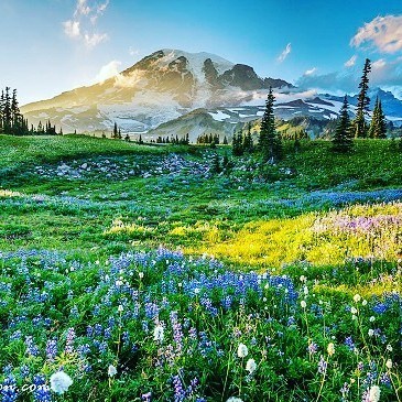
Today I wish I hiking Mount Rainier insteas of being stuck 45 floors up in the finacial district of NYC.
Mount Rainier National park is located about 50 miles South-East of Seattle, Washington. It is located on the most North-Western corner of the United States on the Pacific Ocean, excluding Alaska. Mount Rainier is the 5th oldest National Park in the United States of America. The park is over 225,000 acres large and includes the monstrous 14,411 foot (4,392M) active Mount Rainier Volcano, in which the park is named after. Within the National park there are valleys, waterfalls, meadows, old-growth forests, and more than 25 glaciers (including the largest in the United States outside of Alaska). As I went over yesterday, I am debating with myself on moving to Seattle for a year before I start my world-travel business. While I am in Seattle, I will definitely be exploring Mount Rainier National Park on multiple occasions.
The climate in the Seattle area is pretty consistent year round. Due to its unique geographical location with the weather streams, extreme heat waves are rare as well as very cold temperatures. During winter months, temperature averages from 36-45 degrees Fahrenheit, and during the summer month’s temperatures average from 56-76 degrees. However, this weather can completely change once you head inside the National Park. Once you begin gaining elevation in the National Park, temperatures begin to change. The average during the summer months is in the range of 42-63 degrees Fahrenheit (6-17 Celsius) but can reach into the 90’s(F) at some points. The average during the winter months ranges from around 20-34 degrees Fahrenheit (-5-1.5 Celsius) and can hit extreme lows into the teens (-15F for example).
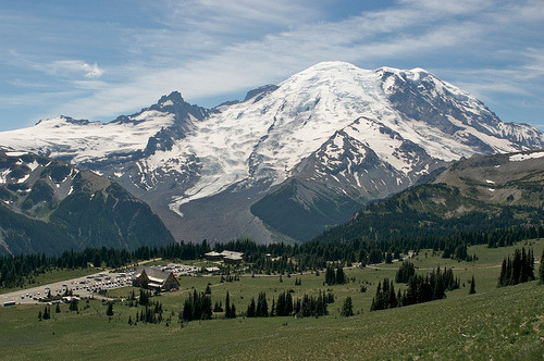
How to get there: Depending on which part of the park you want to explore that day, your entrance and your route will change. The two main roads that get you to the park from Seattle are route 165 (North-west entrance) and route 7 (turns into 706) coming into the South-west entrance. They take about the same time to get to. There are roads that travel through the central parts of the park, however do realize that it is still a national park, and you must park then hike to get to most sections worth exploring. Please use GPS to navigate based off of your preference.. The United States has almost all roads in the country mapped out at this point.. Use it to your advantage.
Wildlife: Mammals that inhabit this national park are especially the cougar (mountain lion), black bear, raccoon, coyote, bobcat, snowshoe hare, weasel, mole, beaver, red fox, porcupine, skunk, marmot, deer, marten, shrew, pica, elk, and mountain goat. The mountain goat is one of the iconic animals in this park and are only commonly found when you travel above 2,000 Ft. in elevation and is most commonly found above 5,000Ft. in elevation. Refer to here for more information on where to see mountain goats in Mount Rainier. The common birds of this park including raptors are the thrush, chickadee, kinglet, northern goshawk, willow flycatcher, spotted owl, steller’s jay, Clark’s nutcracker, bald eagle, ptarmigan, harlequin duck, grouse, peregrine falcon, gray jay, golden eagle, grosbeak and finch. Bird watching for large birds-of-prey can be very rich and rewarding if you plan your trip for the Spring – early Summer months.
What to do while here: What brings the majority of people to this park every year is mainly hiking, site seeing, photography, snow skiing in the winter, bird watching, and climbing the Mount Rainier Volcano itself. There are hundreds of hiking trails all throughout the park. Paradise is the most popular destination in the park. There is a historic Inn located in this region of the park as well as dozens of famous hiking trails including the Skyline trail. Paradise is known as the snowiest place on Earth, reaching over 1,000 inches annually. Longmire is another popular destination in the park due to having 178 total campsites throughout the area as well as having its own visitor center. This is the main starting points for many people as well as the famous Wonderland hiking trail. For more hiking try heading over to the Sunrise area of Mount Rainier National Park. From here you hike the Mount Fremont, Burroughs Mountain and Sourdough Ridge trails, as well as visit some iconic meadows in the Springtime, and get to view the Emmons Glacier. For snow skiing in this area, the Mount Baker Ski Area is where I was told everybody goes near Mount Rainier National Park due to its insane annual snowfall of over 1,000 inches. (closest ski resort to Mount Rainier).
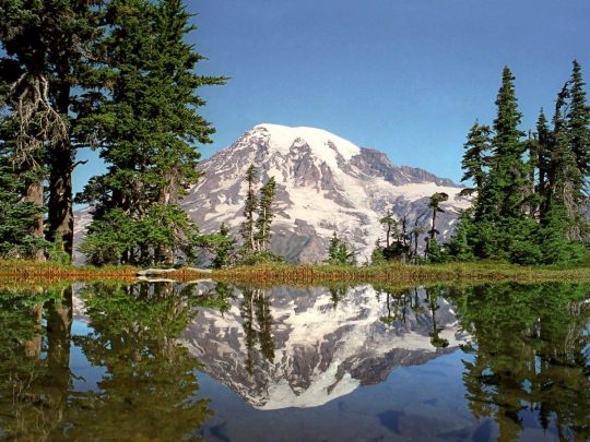
Hiking the Mount Rainier Volcano: Over 10,000 attempts are made to hike / climb to the top of Mount Rainier every year. There is only a 50% success rate of actually reaching the peak who individuals who attempt the climb. Most of the lack of success is due to weather patterns as well as lack of physical condition for underestimating the climb. The hike will take approximately 2-3 days to reach the peak depending on how fast you can climb. There are campgrounds located throughout the climb and if you pass the high camps, they require you to purchase a climbing pass and register (mainly to keep track of individuals who may not make it back). FYI Climbing teams require experience in glacier travel, self-rescue, and wilderness travel so DO NOT under-estimate this climb.
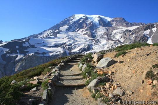
Recommendations: For all smaller sized National Parks (Under 250,000 acres) I recommend 4 days and 3 nights while staying within the park at either a local campground or on your own via tent or camper if allowed by the park. 1 night in this park must 100% be spent climbing to Camp Muir. This is the highest non-technical point (10,080FT) in the state of Washington and most of the United States. This hike is over 8 miles round trip, and includes 4,660ft. of elevation and has the most rewarding of views. The next two days I would spend exploring Paradise as well as the Sunrise regions of the park. My recommendation is to stay within Longmire region and maybe start with a warm-up hike every morning as this is one of the easier hiking areas. Spend the nights enjoying the night-skies and having campfires while drinking beer; after all isn’t this why you came here?! Spend the 4th day filling your time with anything you and your accompanied persons want to do.
If anyone has ever been to Seattle or lives(d) in Seattle, please leave any tips or information!
Thank you for reading. Please like, share and subscribe for more daily places in the world that I am currently dreaming of being at rather than work.
#blog#blogger#exploring#Hike#Hiking#National Park#National Parks#nationalparks#Nature#Outdoors#Seattle#travel#traveling#usa#west coast#world traveler
0 notes
Last Seen Blogs

choxlbun
Blame it on The Gremlins!

mariachiguayaquil
Sin título

livlygalaxy
The Livly Galaxy

toreliable-lead-generation-ufx
Opus external quality assessment

eucitandotudoo
Alê🦋🦋🦋