#north shore mountains
Text

Crows heading to roost at the end of the day.
#crows#birds#birds i love#sky#clouds#vancouver#local#north shore mountains#photographers on tumblr#original photography on tumblr
124 notes
·
View notes
Text

FILE UNDER: NORTH SHORE MOUNTAINS, PELICAN NEBULA, ASTROPHOTOGRAPHY, ETC...
PIC INFO: Spotlight on the North America and Pelican Nebulae in the Cygnus region of the night sky, shining above the "Two Sisters" pointed peaks along the North Shore Mountains, British Columbia, Canada. 📸: Liron Gertsman.
Source: www.picuki.com/media/2498102755360342906.
#The Lions#Ch'ích'iyúy Elx̱wíḵn#Pointed Peaks#North Shore Mountains#Metro Vancouver#Canada#Metro Vancouver British Columbia#The Twin Sisters#Squamish#British Columbia#Mountains#Mountain Range#Photography#Pelican Nebulae#Cygnus Region#Night Sky#Cygnus#Astrophotography#Space photography#Astronomy#Nature#Snowy Mountains#Snow
10 notes
·
View notes
Text

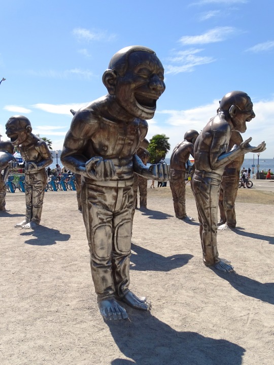


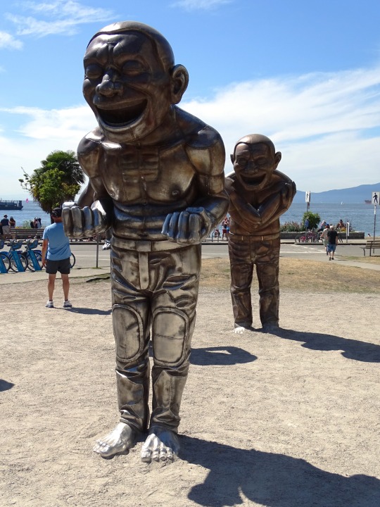


Clouds (No. 1097)
Vancouver, BC
#travel#original photography#vacation#tourist attraction#landmark#landscape#clouds#nature#cityscape#flora#Pacific Ocean#Canada#summer 2023#Vancouver#British Columbia#blue sky#Burrard Inlet#North Shore Mountains#public art#beach#False Creek#Seawall#ship#sand#architecture#A-maze-ing Laughter by Yue Minjun#Stanley Park#Davie Village
26 notes
·
View notes
Photo
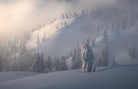
A serene winter scene unfolds with snow-draped trees standing quietly under a soft, glowing light. The rolling contours of the North Shore mountains near Vancouver are a testament to nature’s gentle beauty in hibernation.
#winter scene#snow-draped trees#serene landscapes#soft glow#North Shore mountains#Vancouver#nature photography#winter beauty#gentle hibernation#snowy mountains#tranquil nature#winter wonderland#glowing light#peaceful scenery#Canadian mountains
15 notes
·
View notes
Text
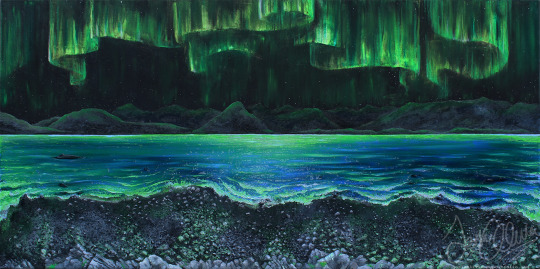
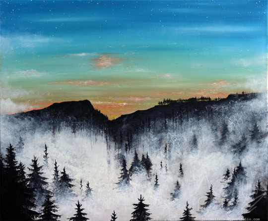

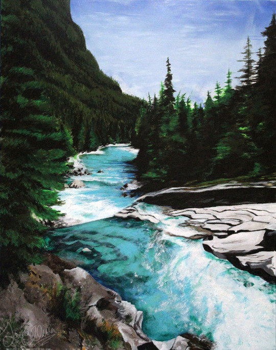
paintings i did 🎨
#top left 'lights over northern shores' top right is the view from duncan bc canada#bottom left is chemainus bc canada. bottom right is glacier national park in the US#jojoliverart#queer artist#trans artist#my art#original art#artists on tumblr#art#traditional art#painting#nature#mountains#pnw#pacific north west#british columbia
30 notes
·
View notes
Text

I also sit this fuckin’ close when anything medieval is on the teleie
#babe & co (ur friends ur all a lil dwarf company now bc i said so ;) lol im the only short king) r u ready 4 ur GOT class????????#the book storylines will blow every1’s mind especially when u find out Jon & Dany aren’t the last Targs (remember maester Aemmon is Targ 2)#it’s Aegon the fucking 1thousenth was never killed by the Mountain so Jon has a living half brother & Dany has not 1 but 2 nephews#& he is probably a factor in her madness bc his little bitch ass really thinks when he landed on Westeros shores she’d pull up & THANK him &#he thinks she’ll be so glad of him she’ll wed him on the spot AND hand over 2 him her biggest & best dragon which is DROGON like bra strap#she is NOT just gonna hand over HER FAVORITE DRAGON NAMED AFTER HER HUSBAND WHO IS HER MOUNT like wt-actual-fuck r u thinking dumbass???????#the only thing she’ll probably willingly do is get Drogon 2 dracerays him on the spot like good luck bra strap#wait until u all find out Catelyn was resurrected as a zombie & SHE ALMOST FUCKIN KILLS BRIANNE!!!!!!!!!!!!!!!!!!!!!!!!!!!!!#okay okay okay but what about the dragon in the Wall?????????????? & there’s probably a frozen Targ in the wall w their dragon#did u all know the place (the furthest northern part of the North beyond the Wall) where Ygritte is looking for the Horn of Winter there’s#ice dragons??? what about how Urine (I fuckin’ REFUSE 2 call him by his real name I mean full disrespect) has the fuckin’ Horn of Winter#& he forces a dude to blast it & he burns alive from the inside out…. put that fuckin horn back where u fuckin found it mister!!!!!!!#the fight at the Fist of the First Men is fucking terrifying like the wights r riding zombie giant ice spiders like nope nope nope don’t#like that one fuckin bit like the show is incredibly watered down so much so it’s like a drop of whiskey in the ocean that’s how toned down#the show is even at its height so the book scenes r horrifying & the book villains r way the fuck worse than their show writing like#show Joffrey is so NICE compared 2 his book writing of u can fuckin believe that & then Ramsey somehow tops him & Urine somehow tops him!!!!
5 notes
·
View notes
Text
why did I just randomly remember the time when I wrote this down
3 notes
·
View notes
Text

jeanne_d_arctique
#jeanne_d_arctique#arctic#north#2022#Nuuk#Greenland#Revolog Kosmos#Olympus OM-4#winter#vivitar 300m f5.4#35mm#landscape#mood#landscapes#nature#ocean#mountains#cape#island#sea#seascape#shore#naturecore
3 notes
·
View notes
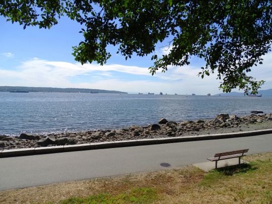
Photo

Vancouver. Spring 2023.
2 notes
·
View notes
Text
Man, I have such a clear image of like. The map of where one of my stories takes place, but if i even tried to put it to paper I'd fuck it up so badly
#like. there's this coastline that's kind of all juttery and stuff and it very gently dips inland down south but goes almost straight and#slightly outwards in the north and about midway along the coast in the east there's a little jut-out where there's a port#north of the port there's these steep cliff faces and down south they wear down into rolling hills and slim sandy shores#the east cape of the continent is up north just off the map by maybe 25000-27000 kilometers. west of the port there's the capital and north#of that is a small old mountain range#the capital is made up of limestone and brick buildings with 4 floors and a network of huge gears and weird pulley systems throughout. they#kind of look like they're almost leaning on each other and the further toward the edges of the town you go the more it looks like the city#home just sprouted in the middle of a storefront or an inn or something overnight#the town square is set up in the ruins of this ivory castle and taken up almost completely by stalls with colorful awnings. it has dark#cobblestone streets surrounding it and no pavements ending where the forged iron and brimstone walls of the administrative buildings'#front gardens begin or branching off further into the city down streets with pavement either side#there's a foundry on the edge of time by which most locals are employed. it has it's own dedicated train line which connects with the#station further south-east. the manors and estates outside of the city have lush forests and red brick walls closer to the residences of#workers and the nobles inhabiting the land#anyways. i'll probably workshop my beloved little steampunk city more later these are just like. notes to get down the image of it i have#in my head because it's so pretty. the stalls in the square look like colorful wild flowers from above <3#boo rambles#unrelated
4 notes
·
View notes
Text

Criss-cross sky.
#evening sky#vancouver#north shore mountains#local#photographers on tumblr#original photographers#trails#ciel
117 notes
·
View notes
Text
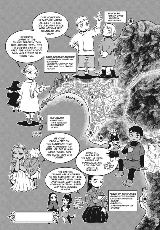
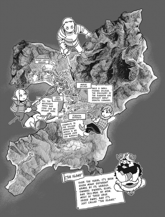
Dungeon Meshi - Kahka Brud and The Island
Kahka Brud - Town adventurer's go through to arrive at The Island, where the dungeon was discovered.
The Island - Island situated off the coast of Kahka Brud, The Dungeon was discovered conected to the village's graveyard.
Merini (Or Melini) - The Village where the Adventurer's stay and make preparations before adventuring in The Dungeon.
Image Texts under the cut
First Image Showing Kahka Brud
Laios pointing up: Our hometown is farther north across the sea. It's a boring place with nothing but mountains and snow.
Marcille pointing to Kahka Brud: Everyone comes to the island through this neighboring town. It's the biggest one in the area. The Magic School Falin and I went to is there too.
Cythis pointing west talking about the canaries: We came from a city on the continent that lies northwest of here. Of the human races there 80% are elves. 20% are "other."
Kabru pointing east (tiny Kuro with Mickbell on his shoulders besides him): Utaya is… was far to the east of here. Humans and Demihumans are still fighting over the territory. Kuro came from that area as well.
Shuro point downwards east: The Eastern Islands are scattered to the southeast of here. There aren't many longlived races, and there's constant internal strife and wars between islands.
Tiny Izutsumi and Rin: We all have roots on different islands.
Dungeons:
Budou Pit
Dwarf-Style Dungeon
Collapsed
Brud Dungeon Cluster
Dwarf-Style Dungeons
Captured
Currently part of the town, and only traces remain
Tower of Night Cries
Gnome-Style Dungeon
Captured and being sealed
Currently administered by the Gnomes
The Island
Compound-type Dungeon
Discovered in 507
Second Image showing details of The Island
"The Island"
Over the years, it's been given many different names by it's various owners: Dwarfs, Elves, and tall-men. By now, most of these have faded away and it's just called "The Island."
Merini Village
Once a small fishing village, the discovery of The Dungeon has brought about drastic changes
[On the north-most part of the village]
Island Lord's Mansion
[Middle of the village, near the shore]
High Street
All the necessary tools and food can be bought here.
[Deeper to the southeast of The Island]
Dungeon Entrance
Connects to the Village graveyard, which is no longer used for burials.
[End of Descriptions]
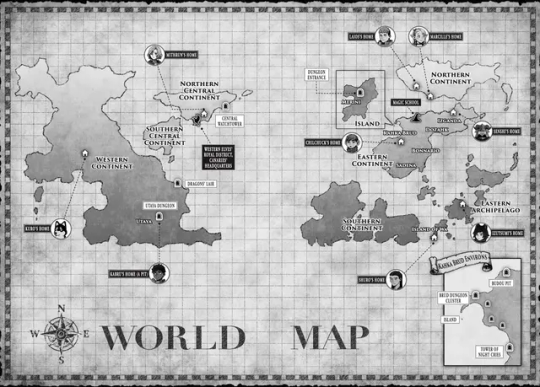
Here's the world map in case you want to check it along with the descriptions from the characters, I'll make a dedicated post for it later on.
#dungeon meshi#worldbuilding#maps#The Island#dungeon meshi map#Dungeon Meshi Spoilers#the canaries#Laios Party#shuros party#Laios Touden#Falin Touden#Marcille Donato#Senshi#Senshi of Izganda#Kabru#Kabru of Utaya#Shuro#toshiro nakamoto#Kuro#Kuro Dungeon Meshi#official translation#for referencing
2K notes
·
View notes
Text


Clouds (No. 1098)
Vancouver, BC (two pics)
Sea-to-Sky Highway, BC (eight pics)
#travel#original photography#vacation#tourist attraction#landmark#landscape#clouds#nature#cityscape#flora#Pacific Ocean#Canada#summer 2023#Vancouver#British Columbia#blue sky#countryside#Howe Sound#North Shore Mountains#Nch'ḵay̓#Mount Garibaldi#snow#Sea-to-Sky Highway#coast#forest#woods
5 notes
·
View notes
Photo

The North Shore mountains near Vancouver are absolutely serene, draped in winter's finest. Delicate sunlight dances across snow-covered pines, creating a tranquil landscape that whispers the beauty of the season.
#North Shore mountains#Vancouver#serene landscapes#winter beauty#snow-covered pines#tranquil scenes#delicate sunlight#winter season#nature photography#Canadian mountains#mountain views#winter wonderland#peaceful moments#nature's whispers#snowy landscapes
3 notes
·
View notes
Text
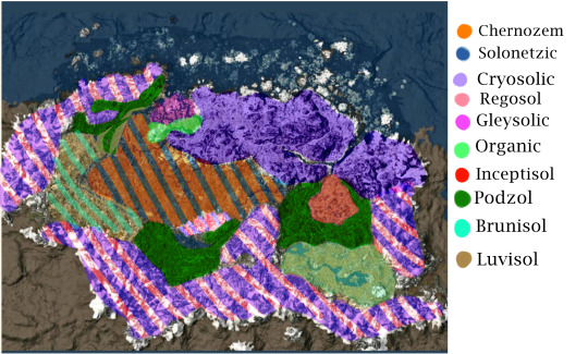
Long awaited, here is the soil map of Skyrim using the Canadian System of Soil classification. Brief description of my conclusions under the cut:
Chernozem: Whiterun Hold is likely home to the majority of Skyrim’s Chernozems. The majority of biological carbon sequestering in grassland environments are below ground, within the root systems. Organic material- humus, builds up, causing the upper layers of the soil to take on a dark colour. Additionally, Solonetzic soils could be present, peppered throughout the hold if the parent material to the soil is salty enough.
Cryosols are formed in Skyrim’s far North and high alpine regions. The mean annual soil temperature being 0 degrees C, with permafrost conditions. Freeze-thaw cycles lead to permafrost at the soils surface, but also cryoturbation: soil movement arising from frost action.
Additionally in mountainous regions, you would find Regosols. Soils which develop on unstable landforms and have had little time to develop, such as mountain slopes, or river floodplains.
Gleysols occur across the landscape of Skyrim, but primarily in Hjaalmarch. Gleysols are commonly found in depressions or low-lying areas where water saturates the soil continuously, leading to a molted characteristic to the soil.
Organic soils would primarily be found in the water saturated soils of Hjaalmarch. These are wetland soils found in forested areas and are commonly known as peat, muck, bogs or fens.
Borrowing from the USDA soil taxonomy, Inceptisols are light colored soils with moderate alteration, occurring under cool and cold climates. These soils would be found in the Eastmarch caldera.
Luvisols are associated with forested landscapes overlying loamy glacial till, or on clayey lacustrine deposits. Lake Honrich dominates a large portion of the Rift, according to UESP, seemingly draining from the lake. I believe this to be the site of a melted glacier, the lake being meltwater. Clay sediments are associated with lakes because of their deposition, coarser sediments bordering the lake near the shore, and finer particles at the deepest reaches. Additionally, at the end of the Karth river, where sandy deposits would be deposited at Solitude, before the stream looses power further down the river, leaving only clay to be deposited.
Podzols are associated with igneous parent materials, coniferous vegetation and high acidity. Primarily they are found in Falkreath Hold and Southern Eastmarch.
Brunisols are an intermediate stage between Regosols (undeveloped soils), and Podzol or Luvisols. I believe with the unstable, mountainous landscape of the Reach, soils would remain still rather undeveloped. Brunisols would also be interspersed among the Luvisols.
3K notes
·
View notes
Text
Protocol Sierra Delta in NSMRS is fun lol
youtube
0 notes
Last Seen Blogs

st0n3d4ndc0nfus3d
Confused.

rhuza-sukaru
Head over heels for Tokyo Ghoul ♡

gyoza-man
Oh, Ya Know, Whatever

eillymarvel
Mactracks