#soil map
Explore tagged Tumblr posts
Visit Tumblr Blog
Explore Tumblr blogs with no restrictions, modern design and the best experience.
Last Seen Tumblr Blogs


Fun Fact
Tumblr Inc. is using 66 technologies for its website.
Text


Once I had enough high-resolution climate data to work with, the final part of the Climate phase was the creation of maps with discrete climate zones, which I produced in both the Trewartha classification scheme, left, and the Köppen classification scheme, right.

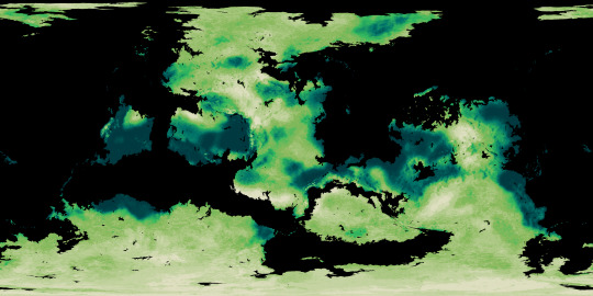

The final phase of the Ayrum mapmaking project was to create realistic satellite style maps, which began with mapping out soil colors and the ground cover of vegetation generally and tree-analogues specifically.
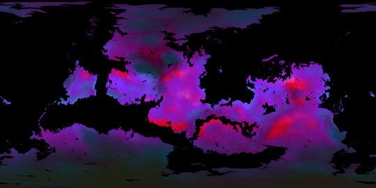
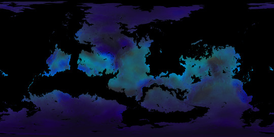
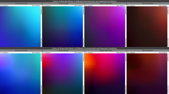
Once I knew where the plants belonged, I then determined what colors they'd be in the conditions they're adapted for, as seen in the maps, and under seasonal variation, with the chart showing how plants with certain adaptations react to seasonal changes in those conditions.

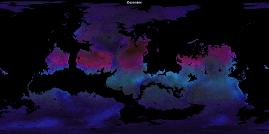
In these gifs we see the ground plants and tree canopies changing colors as the Solstices and Equinoxes expose them to greater or lesser rainfall and harsher or milder temperatures than what they're adapted for. Neither of these gifs provide a true image of what the surface looks like from space, but rather of the in-person appearance of whatever plants may be present.

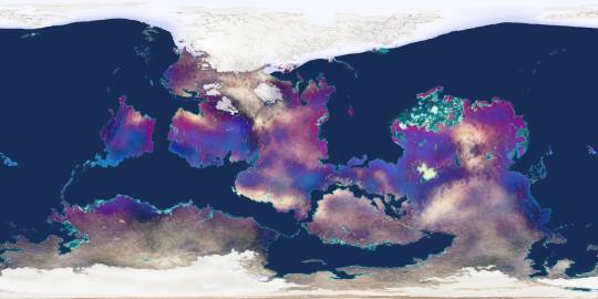
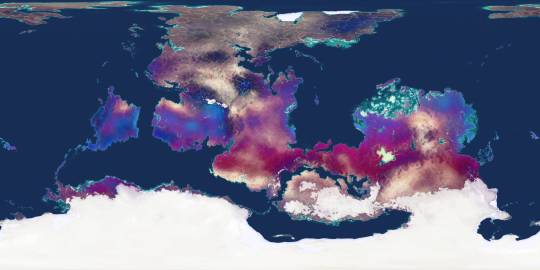
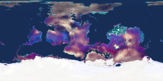
Finally, using the vegetation density maps as raster masks for the seasonal plant color maps, and layering those with the snow-and-ice maps over the soil color map, we now have a much truer image of Ayrum's surface as of its (Northern) Winter, Spring, Summer, and Autumn months.
#Ayrum#mapmaking#digital painting#imaginary maps#imaginary climate zone maps#Trewartha climate scheme#Koppen climage scheme#worldbuilding#commission#major project#seasonal data sequence#imaginary soil color maps#imaginary vegetation maps#vegetation extent#vegetation color#satellite-style maps#Photopea#Christopher Maida Artwork
52 notes
·
View notes
Text

Soil Map of the United States. By Curtis F. Marbut and Associates in the Soil Survery, U.S. Department of Agriculture, F.J. Marschner, Cartographer and Associate in Compilation. 1931.
#1900s#1930s#map#Maps#internet archive#archive.org#image#dirt#who doesn’t love dirt#soil science#ecosystem
2 notes
·
View notes
Text
my favourite thing in the whole wide world is creating a normal post and then using the notes as a completely unrelated diary entry
#i WILL make a post about bungo stray dogs only to rant about my upcoming geography exam in the tags#why? becaues idk i have no where else to talk about it#“create a separate post” i hear u say#no#ANYWHO i have my geography exam tomorrowi m going to shit myself#BUT i have an unconditional to st andrwes (the best uni in my country!!!) so im not too stressed#but i will say i know absolutely jack shit#like what the fukc are the farell cells n shit ?? soil profiles??#nobody told me it was sciency i just wanted to talk about maps :[#lea.txt
11 notes
·
View notes
Text
By the nineteenth century, the night-soil men had evolved a precise choreography for their labors. They worked the graveyard shift, between midnight and five a.m., in teams of four: a “ropeman,” a “holeman,” and two “tubmen.” The team would affix lanterns at the edge of the cesspit, then remove the floorboards or stone covering it, sometimes with a pickax. If the waste had accumulated high enough, the ropeman and holeman would begin by scooping it out with the tub. Eventually, as more night soil was removed, the men would lower a ladder down and the holeman would descend into the pit and scoop waste into his tub. The ropeman would help pull up each full tub, and pass it along to the tubmen who emptied the waste into their carts. It was standard practice for the night-soil men to be offered a bottle of gin for their labors. As one reported to Mayhew: “I should say that there's been a bottle of gin drunk at the clearing of every two, ay, and more than every two, out of three cesspools emptied in London; and now that I come to think on it, I should say that's been the case with three out of every four.”
— The Ghost Map: The Story of London's Most Terrifying Epidemic - and How it Changed Science, Cities and the Modern World (Steven Johnson)
#book quotes#steven johnson#the ghost map#the ghost map: the story of london's most terrifying epidemic - and how it changed science cities and the modern world#history#sanitation#waste management#employment#labour#victorian era#britain#victorian britain#england#london#henry mayhew#night soil men
6 notes
·
View notes
Text
@kagrenacs
it’s easy to forget, so I’ll remind y’all: you can make fantasy versions of anything. yes even things you might not think about. like soil types. I am thinking of fantasy soil types right now
#have u already been tagged in this lol#I just saw 'fantasy' and 'soil types' and thought of ur magnificent map
79K notes
·
View notes
Text
daddy is being honest kitten, if my seeds don't germinate its so fucking over
#i planted them yesterday i need to calm down#but its still a little chilly out and even tho im growing indoors i worry they won't be warm enough#i don't own and can't afford heat maps and lamps and humidity domes#but also im like????? if the elders could do it with nothing but common sense than so can i#i still have extra seeds extra soil and extra pots#i can try again if i fail#but please don't fail!!!! AAAAAA
1 note
·
View note
Text
Unearthing the Future: Emerging Trends in the Digital Soil Mapping Platforms and Applications Market | BIS Research

In the era of precision agriculture, understanding soil health and composition has become paramount for optimizing crop yields and ensuring sustainable farming practices. Digital soil mapping platforms and applications are at the forefront of this agricultural revolution, providing detailed insights that empower farmers and agribusinesses to make informed decisions. This article delves into the burgeoning digital soil mapping market, highlighting key trends, market segmentation, growth projections, and how various industries are leveraging these advancements to stay competitive.
Market Overview: Robust Growth Trajectory
The global digital soil mapping platforms and applications market is experiencing significant growth. Valued at $228.2 million in 2023, it is projected to reach $798.5 million by 2034, registering a compound annual growth rate (CAGR) of 12.16% during the forecast period of 2024-2034. This upward trend is driven by the increasing adoption of precision agriculture, advancements in geospatial technologies, and a heightened focus on sustainable farming practices.
Key Trends Shaping the Market
Integration of IoT and Advanced Sensors:
IoT devices and sensors enable real-time monitoring of soil moisture, temperature, and nutrients.
Helps in precision irrigation and fertilization, improving crop yields.
Adoption of AI and Machine Learning:
AI-driven analytics predict soil health trends and pest infestations.
Machine learning enhances decision-making for farm management.
Focus on Sustainable Agriculture:
Soil mapping tools aid in regenerative farming by tracking organic matter and erosion risks.
Supports biodiversity and long-term soil health.
Government Initiatives and Support:
Subsidies and policies encourage farmers to adopt digital agriculture solutions.
Helps boost food security, especially in developing regions.
Request for a sample research report on the digital soil mapping platforms and applications market
Key Market Segmentation
Segmentation 1: by Application
Agriculture Cooperatives
Government and Private Research Institutes
Agribusiness Companies
Others
Segmentation 2: by Product Type
Drone Scouting
Mobile Scouting
Satellite Imagery
Segmentation 3: by Region
North America
Europe
Asia-Pacific
Rest-of-the-World
The North America region dominated the global digital soil mapping platforms and applications market and is expected to maintain its dominance over the forecast period from 2024 to 2034. The region is home to multiple leading companies, including Trimble Inc., Deere & Company, and Ag Leader Technology.
Industries Leveraging Digital Soil Mapping
Various sectors are capitalizing on digital soil mapping technologies to enhance their operations and maintain a competitive edge:
Agriculture: Farmers and agronomists use soil mapping to tailor crop management practices, leading to improved yields and resource efficiency.
Environmental Management: Organizations involved in land conservation and environmental monitoring employ soil mapping to assess soil degradation and plan remediation efforts.
Urban Planning and Construction: Urban planners and construction firms utilize soil data to inform land use decisions, ensuring infrastructure stability and sustainability.
Recent Developments in the Global Digital Soil Mapping Platforms and Applications Industry
In February 2024, EOS Data Analytics (EOSDA) announced a collaboration with AgriProve, Australia’s leading soiltech carbon developer, to enhance soil organic carbon (SOC) monitoring using AI-powered satellite imagery. This collaboration is supported by the Australian government with a $6.0 million grant. The collaboration aims to create detailed soil carbon maps and predictive models, offering farmers invaluable insights for optimizing land management practices and improving soil and climate resilience.
In January 2024, EarthOptics surpassed one million acres of physically mapped farmland and ranch land, positioning its SoilMapper platform as a market leader in comprehensive soil intelligence. Since 2021, the company has mapped land across four continents and 45 U.S. states, utilizing advanced technologies such as ground penetrating radar and electromagnetic induction scanning.
Get more insights on the agriculture market research reports.
Future Market Outlook
The digital soil mapping market is poised for continued expansion, driven by technological advancements and increasing awareness of sustainable agriculture. Key factors influencing future growth include:
Technological Innovations: Advancements in remote sensing, data analytics, and machine learning will enhance the accuracy and usability of soil mapping platforms.
Regulatory Support: Policies promoting sustainable agriculture and environmental conservation will encourage the adoption of digital soil mapping tools.
Global Food Security Concerns: As the global population grows, optimizing agricultural productivity through precision farming practices will become increasingly critical.
Conclusion
Digital soil mapping platforms and applications are revolutionizing agriculture by providing detailed, actionable insights into soil health and composition. The market's robust growth trajectory reflects the increasing recognition of these tools' value across various sectors. As industries continue to prioritize sustainability and efficiency, integrating digital soil mapping into operational strategies will be essential for maintaining competitiveness and ensuring long-term success.
#Digital Soil Mapping Platforms and Applications Market#Digital Soil Mapping Platforms and Applications Industry#Digital Soil Mapping Platforms and Applications Market Report#Digital Soil Mapping Platforms and Applications Market Growth#Digital Soil Mapping Platforms and Applications Market Size#Digital Soil Mapping Platforms and Applications Market CAGR#Digital Soil Mapping Platforms and Applications Market Trends#Digital Soil Mapping Platforms and Applications Market Analysis#Agriculture#BIS Research
0 notes
Text
Kenya banks on digital soil mapping project to address growing food security concerns
In a significant move to tackle declining soil fertility and boost agricultural productivity, the Kenya Agricultural and Livestock Research Organisation (Karlo) has embarked on an ambitious three-year project to develop comprehensive digital soil fertility maps across the country. The National Agricultural Value Chain Development Project, funded by the World Bank, aims to analyse over 77,000…
0 notes
Text

it's cos I'm always on that damn soilsofsask.ca looking up chernozems
1 note
·
View note
Text
Indian Geography Map » Political, Rivers, Soils, Climate & Other
Indian Geography Map » Political, Rivers, Soils, Climate & Other india political map Geography Of India | Indian Geography india river map India River System – Drainage System Of India Natural Divisions of India Map India Land Area » Natural Divisions of India peninsular plateau in india map India Land Area » peninsula plateau of india coastal plains of india map India Land Area »…
#agriculture in india map#climate of india map#coastal plains of india map#india political map#india river map#mineral resources map of india#Natural Divisions of India Map#natural vegetation of india map#peninsular plateau in india map#soil map of india#the islands of india map
0 notes
Text


The SA border changing the soil type. Ok.
SORSE
#I’m Ona ADHD side quest#gonna look at a soil map of my local area#cause I live ina minecraft biome ass place#ven#map#soil#data
0 notes
Text
How Can Digital Soil Mapping in the USA Be Rewarding for Framers?
In agriculture, the foundation of crop health and productivity lies beneath our feet—in the soil. This dynamic, living ecosystem plays a pivotal role in successful farming. Understanding soil means leveraging its potential to improve agricultural outcomes. Soil mapping in the USA makes this possible. The soil’s balance of nutrients, moisture, and organic matter profoundly impacts crop yields, farm profitability, and ecological sustainability. By using soil mapping, we can contribute to a healthier planet, ensuring that our farming practices are sustainable and environmentally responsible.

The process of soil surveying and mapping involves collecting data from fieldwork and laboratory analysis. This information is then combined with GIS vector data, which contains the geometry of the soil mapping unit polygons. Previously, this data was produced in analogical format, but now, examples of soil databases and vector data themes can be found online through various resources across Canada, the USA and internationally. Soil maps can be very easily accessed through services like web soil survey programs at the national or regional level. It’s important to note that the information content of the soil map, which is highly dependent on the scale, should be the starting point for any analysis.
0 notes
Text
When I was a field school student nobody wanted to ride the hour drive to site in the packed Archaeology Van. Any chance we got we rode to the boat launch with the visiting lecturers and researchers.
And spending 2 hours in a Tacoma backseat with our soil sciences prof was maybe the best choice several of us ever made. He'd just casually talk about the glacial history of the region, point out cool rock formations, and talk about how you can pick up a spadeful of soil from a village site and tell people lived there by how different it was from forest soils.
At one point I mentioned a tiny town I stopped for lunch in on trips to the Yukon and he goes "hey, did you know there's permafrost on the north side of the rage overlooking that diner? Most southern place I've ever found it."
You expect dirt to be boring, but you really just need to hear about it from the right people.
I’ve been doing some field work with geologists this winter and I’m kind of amazed by how these dudes can pick up a handful of dirt and talk about it for an hour using terms I’ve never heard of. Like wow you see a whole universe in there that I don’t. The world is truly full of beauty and we only comprehend a fraction of it.
10K notes
·
View notes
Text
When will the cicadas come out?
Cicadas emerge when the soil temperature is 65 degrees at 8 inches deep.
A handful of tools can tell you the current soil temperature and forecast the upcoming soil temperature.
0 notes
Text
Practice taking photos on the bus. Totally worth it. Lol 😂
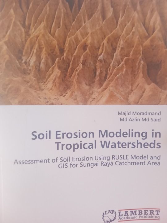


This research is quite useful in my remote sensing study.(But I don't have RUSLE model.....er...nevermind.)
#My camera#books#soil erosion modeling in tropical watersheds#Malaysia#Camera#Tropical#watersheds#remote sensing#Topographic map
0 notes
Text
plink inspiration
simon ghost riley adores when you're a little bit messy during sex, all due to his fault, with your hair mussed over along the crumpled pillowcases, every ounce of skin mapped throughfully with wet hickeys and sweet, tingling bruises, sensitive nubs of your breasts all swollen and pebbled, skin around gathering goosebumps, but what attracts his attention the most, is how soaked your panties are, soiled completely, tucked aside to expose your puffy pussy.
he jerks the hot, swollen girth of his cock all over the thin, cotton fabric, precum pearly and dripping steadily off his rudy, engorged tip, soaking into your panties and mixing in with the slick mess that oozes helplessly out of your pulsing, gaping hole, but simon keeps leaving her without any attention, needy and soppy while he rubs down into your cunt, catching on the fluttering folds and your ruined underwear.
simon plunges in your pussy only when his stomach coils with impending orgasm, making his cock twitch and throb restlessly, before sinking in the slick, cushiony tightness of your hole, pliable, walls stretching to accommodate his thick length, clamping around impatiently, with little noises escaping out your gaping mouth breathless and saccharine, keening prettily while he humps in with quick pumps, your pretty legs only spreading wider, encouraging him for more.
main masterlist. quidelines.
#𐔌 . 𝘫𝘶𝘭𝘺 𝘸𝘳𝘪𝘵𝘦𝘴 .ᐟ#simon ghost riley smut#simon riley x f!reader#simon riley smut#simon riley x reader#simon ghost riley x female reader#simon riley fluff#simon ghost riley x reader#simon ghost riley comfort#simon riley x female reader#simon ghost riley fluff#simon riley comfort#simon riley x you#simon ghost smut#simon ghost riley#ghost x f!reader#simon ghost x reader#simon ghost x you#ghost x female reader#ghost x reader#ghost cod#ghost x you#simon riley drabble#simon ghost riley drabble#ghost thoughts#simon ghost riley headcanons#simon riley headcanons
3K notes
·
View notes