#thinkaboutmapsshop
Explore tagged Tumblr posts
Visit Tumblr Blog
Explore Tumblr blogs with no restrictions, modern design and the best experience.
Last Seen Tumblr Blogs


Fun Fact
12.7% of mobile users access Tumblr.
Photo
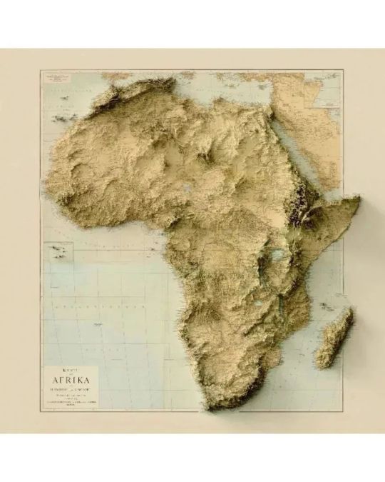
Repost @thinkaboutmaps —— Exaggerated relief maps by @thinkaboutmapsshop showing almost all the continents. These are old maps with digitally rendered reliefs. Year of the original maps: Africa (1884), North and Central Americas (1911), South America (1907), Europe (1875), Middle East (1916) and Asia and Australia (1939). 🌀 Posters and framed maps available with 20% off and free shipping worldwide (2D maps). Check out the link in our bio! . FOLLOW @thinkaboutmaps and @thinkaboutmapsshop for more! . . . . . . . 🌀 #thinkaboutmapsshop #thinkaboutmaps #3d #art #map #maps #mapping #old #oldmaps #geology #mountain #relief #topography #southamerica #asia #oceania #australia #europe #africa #northamerica #centralamerica #middleeast https://www.instagram.com/p/ClwUqOkylhk/?igshid=NGJjMDIxMWI=
#thinkaboutmapsshop#thinkaboutmaps#3d#art#map#maps#mapping#old#oldmaps#geology#mountain#relief#topography#southamerica#asia#oceania#australia#europe#africa#northamerica#centralamerica#middleeast
2 notes
·
View notes
Photo

Lo nuevo: Petal Maps, el nuevo Google Maps de Huawei. #gogolemaps #petalmaps #huawei #mapping #earth #geo #city #cities #country #climate #weather #thinkaboutmaps #thinkaboutmapsshop #costarica #geek https://t.co/qbe4HTNbV2 https://www.instagram.com/p/CG3VE7OAkiL/?igshid=ise1h35281ox
#gogolemaps#petalmaps#huawei#mapping#earth#geo#city#cities#country#climate#weather#thinkaboutmaps#thinkaboutmapsshop#costarica#geek
0 notes
Video
instagram
(via Think About Maps on Instagram: “Map showing the profile of the Great Lakes 🌀 Source: https://t.co/xlXTzbLEwk. . FOLLOW @thinkaboutmaps and @thinkaboutmapsshop for…”)
3 notes
·
View notes
Photo
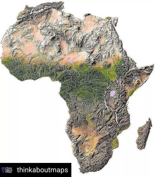
Reposted from @thinkaboutmaps Topographic map of Africa. 🌀 "The average elevation of the continent approximates closely to 600 m (2,000 ft) above sea level, roughly near to the mean elevation of both North and South America, but considerably less than that of Asia, 950 m (3,120 ft). In contrast with other continents, it is marked by the comparatively small area of either very high or very low ground, lands under 180 m (590 ft) occupying an unusually small part of the surface; while not only are the highest elevations inferior to those of Asia or South America, but the area of land over 3,000 m (9,800 ft) is also quite insignificant, being represented almost entirely by individual peaks and mountain ranges. . “As a general rule, the higher tablelands lie to the east and south, while a progressive diminution in altitude towards the west and north is observable. Apart from the lowlands and the Atlas mountain range, the continent may be divided into two regions of higher and lower plateaus, the dividing line (somewhat concave to the north-west) running from the middle of the Red Sea to about 6 deg. S. on the west coast”. 🌀 FOLLOW @thinkaboutmaps and @thinkaboutmapsshop for more! 🌀 #maps #map #mapping #geography #earth #city #cities #country #climatechange #travel #touristic #education #topography #geology #inselberg #germany #africa #main #features #plateau #namibia #egypt #southafrica #geomorfology #plain #kilimanjaro #elevation #mountain #atlasrange https://www.instagram.com/p/Cf011OaLAd4/?igshid=NGJjMDIxMWI=
#maps#map#mapping#geography#earth#city#cities#country#climatechange#travel#touristic#education#topography#geology#inselberg#germany#africa#main#features#plateau#namibia#egypt#southafrica#geomorfology#plain#kilimanjaro#elevation#mountain#atlasrange
0 notes