#upper peninsula map
Text
I remember there being a tumblr post (or blog??) a while back showing the funny ways Michigan is depicted or omitted on maps.
Can’t find it now, but here’s a very strange triangular Michigan from Betty Boop “When My Ship Comes In” (1934)
#rip maine also lol#michigan’s lower peninsula is shaped like a mitten that’s how you draw it#the upper peninsula can be your other hand too#but I don’t see that as commonly. the UP is more abstract#betty boop#fleischer#maps
4 notes
·
View notes
Text
Sharing some U.P. love. <3
#upper peninsula#pure michigan#michigan artist#Michigan map#one creative pup#print on demand#redbubble#Michigan#green#onecreativepup#art#laptop#skin#heart#love#state#U.P.
1 note
·
View note
Text
A team of archaeologists has been rewarded for trekking some 60 kilometers (37 miles) into the dense Yucatan Peninsula jungles of southern Mexico: they've discovered a long-lost ancient Maya city that there are no previous records of.
Of course a lot of the city has been lost to time: the archaeologists say that the stone columns may well have originally been entrances to upper rooms. There's also a ball court, for recreational and perhaps religious purposes.
Ahead of the field work done by the researchers, overhead LIDAR scans were carried out across the area. The technology uses the reflections of laser beams to detect buildings that are otherwise hidden from view by trees and undergrowth.
"The biggest surprise turned out to be the site located on a peninsula of high ground, surrounded by extensive wetlands," says archaeologist and team leader Ivan Šprajc, from the Slovenian Academy of Sciences and Arts (via Google Translate).
Continue Reading
385 notes
·
View notes
Text
THESE MOUNTAINS SHOULD NOT EXIST
a rant/essay about dreamland's topography
disclaimer: i am a second year ENVS student and may get some details wrong. i don't really feel like sending this to my advisor (the local geologist) to proofread, so it'll have to do. i think she has more important things to do right now than read my kirby rant
to begin, we have to establish some basic rules about geology:
how do mountains form?
mountains come to be in a few ways: shifting plates and hot spots. hot spots are technically also to do with shifting plates, but we'll get to that later. let's talk about the plates first.
there are two kinds of tectonic plates: continental and oceanic. ocean plates are denser than continental plates, which means when an ocean and continental plate converge, the ocean plate will subduct under the continental plate. when two continental plates converge, because they are of similar density, they will collide. this process creates mountains.

mountains created by converging continental plates can be seen, for example, with the Himalayas. in this case, the mountains were formed by the Indian plate pushing up into the Eurasian plate. this method is off the table for dreamland because it is shown to be a peninsula (or at least a thin strip of land) surrounded by water.
ocean-continental convergence also creates mountains, but in a different fashion. this is the more relevant method because dreamland also has a volcano, an active one at that.
when ocean plates subduct under the land, they are forced down into the earth until they reach a melting point. sometimes this newly formed magma travels back to the surface, creating a hot spot. if this magma breaches the surface, it forms a volcano (that eventually cools into a mountain). this method can be seen in the Cascade mountains and the Andes.

the volcano/mountain's proximity to the coast depends on how steep the ocean plate's descent is. if we take a look at how close dreamland's mountains are to the shore...

...the ocean plate would have to be hitting its melting point almost immediately after subducting. forgive me for thinking this is unrealistic.
however, the inclusion of a volcano in this range is realistic! an O-C convergence would create a volcano like this. its portrayal within the show isn't really correct, but that's a post for a different day.
how this could potentially happen
not all hope is lost for the ocean-bordering mountain range, sort of. there are a few things that could have happened in popstar's history to cause something like this.
firstly, we should look at the Appalachian mountains. how did they get there? the North American plate is bordered on its east side by a mid-ocean ridge, where new crust is being created.
the Appalachians came to be around the time Pangea was coming together--the collision of the North American and African plates created the mountain range, and over time Pangea split apart, forcing the mountains away.
any map of tectonic plates will reveal a large split through the Atlantic ocean--this is a divergent boundary, where plates are being pushed apart in favor of creating new lithosphere (crust/upper mantle).
so, with all this in mind, there are a few things it could mean for our mountain range:
dreamland is actually an island, and we don't know because the overhead view doesn't show it
this would mean hot spots are relevant again: if a plate moves over a hot spot, magma can form into islands, especially volcanic ones. this is how Hawaii was formed, and why it is prone to volcanic activity. given that dreamland is an island, this would explain the presence of mountains. Hawaii's tallest peaks are still inland rather than right on the coast, but it's close enough.
2. a new fault/divergent boundary formed between dreamland's mountains and the opposing plate that created them
new faults aren't uncommon, though they don't always succeed. the New Madrid Seismic Zone, for example, made a small break in the American Midwest, but didn't get much farther than that. a successful fault or new divergent boundary could potentially push dreamland's mountains away from their neighboring plate. this is more like what happened to the Appalachians--though they're pretty far inland, so take that as you will. the new boundary would have to form quite close to the mountain range for them to be right on the shore like this.
3. the water has eroded away the land leading up to the mountains
now this isn't really one i have any backup for, i just wanted to throw it in because it came to mind. while it's possible for the ocean to have greatly eroded the land if it's been here for a long time, the mountains would still have to be very close to the shore to end up where they are. dreamland's proximity to the ocean could imply it has a delta at the end of the peninsula, and maybe one of the routes is along the mountains so the channel eats away at the shore for a while...who knows. but this one doesn't feel too realistic, either.
conclusion
as far as i'm aware, it isn't completely impossible for these mountains to exist, but they aren't exactly realistic, either. their proximity to the shore leaves too many questions that are hard to answer without any information about popstar's history and plate tectonics. most likely, dreamland is on an island, and was created as its plate moved over a hot spot. the existence of an active volcano implies that it is still sitting over this hot spot, and will eventually move away from it.
i must really miss my geology class if this is what i'm doing with my spare time. thank you for reading.
#kirby#kirby right back at ya#rhyn rambles#long post#i'm taking hydrology next term which means i might end up being annoying about something else soon#at the very least the river system looks pretty realistic#rivers are harder to mess up than mountains#i'll complain about the volcano if anyone's interested#i have some things to say that include comparing it to dante's peak
16 notes
·
View notes
Text
*looks through index cards of controversial american geography opinions* long island is just south new england. the upper peninsula rightfully belongs to wisconsin. colorado is not a rectangle, it just looks that way on bad maps. granting alabama access to the sea was a mistake. detroit is an exclave of ohio. i can never remember which one is nebraska and which one is kansas. "kansas" and "arkansas" should be pronounced the same. new mexico sucks, and should be returned to old mexico.
31 notes
·
View notes
Text
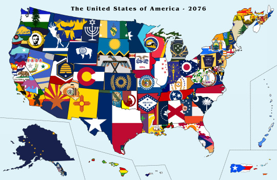

Map with flags of the United States of America circa 2076. Notable Changes:
1. DC, now officially the Douglass Commonwealth, became the 51st state along with the eastern counties of Oregon (now the state of Lincoln) who voted in the greater Idaho movement, Puerto Rico, and Mariana (a state comprising of Guam and the Northern Mariana Islands).
2. North Florida split from the rest of Florida, and now there are two Floridas, Florida-Dixie and Florida-Caribe
3. The Navajo Nation became a state
4. Upstate New York becomes a state, called North New York, as does the almost-a-state Sequoyah
5. California split into 7 Smaller States, California, Bay Area, Los Angeles, Frémont, Jefferson, Joaquina, and Southern California
6. The Virgin Islands and American Samoa (now Samoa Amelika) became states after floating city technology grew
7. 6 Planned mini City States (a la DC) get admitted. The US now has 10 Capitals to avoid bureaucratic collusion and corruption. The USA now has 10 capitals, DC (Capital of the executive branch), Vespucci (located in former parts of Iowa, congressional capital), Twainstun (located in former parts of northern Maine, judicial capital), MLK (located on Gulf Coast, where all governors meet to talk), New York (economic capital), Liliuokalani (located in former parts of Oregon, diplomatic capital), Eisenhower (located in former Alaska pan handle, military and intelligence capital), Sequoyah (Reservation version of MLK), Quintanilla (former southern tip of Texas, Space Station capital cause future), and Frémont (cultural capital, museums here)
10. Nova Scotia and New Brunswick become states following the bloody Canadian civil war, Yukon joins Alaska
11. Israel is moved to Montana in an area of land 7x the size of modern Israel, it’s initially an independent country but votes to join the USA
12. Michigan upper peninsula becomes a state after the Yooper terror attacks for self autonomy of 2069
13. Most states change their flags to be prettier
6 notes
·
View notes
Photo

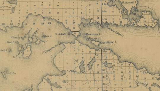
Sketch Map of the Public Surveys in Michigan, 10/26/1857
File Unit: 35th Congress, 3/4/1857 - 3/3/1859
Series: Published Record Set of Maps, ca. 1805 - ca. 1958
Record Group 46: Records of the U.S. Senate, 1789 - 2022
Image description: A map of both peninsulas of Michigan, neatly divided into squares. I think they mostly correspond with modern townships, which are 36 miles square. Each square is marked according to whether the field notes have been recorded, transcribed, descriptive sheets recorded, etc.
Image description: A zoomed-in view of the portion of the map where the Upper and Lower peninsulas meet. The irregular shorelines contrast with the square lines of the manmade divisions.
58 notes
·
View notes
Note
Please elaborate about the border patrol incident
okay so, the border patrol incident is not really that dramatic, but it is very funny to me. when i was a young 20-something, one summer a friend and i decided to go on a month-long roadtrip across the continent and back. we had a lease on an apartment that didn't start until september, shitty little service industry jobs that didn't care if we disappeared for four weeks, and absolutely no standards for like, sleeping conditions or whatever. we got a hotel or motel room every 4-5 days to shower and stuff but mostly we were living out of my 2001 toyota camry, which ran just fine but was not in the best shape aesthetically due to being pretty old and also due to young me having sub-par depth perception and occasionally backing it ungently into things. also, because we were between apartments, the vast majority of our earthly belongings were packed into the backseat and trunk of this car.
the route of the trip was pretty meandering, but some stretches of it were based on the summer tour dates of bands we liked -- one of my favorites things to experience in a new city is its small/medium music venues, so this was a great excuse for doing that. anyway, we'd started the trip by driving north to montreal and then cutting west, but instead of going over the great lakes through western ontario we headed south, crossed back into the us at sarnia and went up through michigan's upper peninsula, wisconsin, minnesota. the night before we crossed the border again, we parked the car in the massive parking lot of the walmart supercenter in bemidji to sleep, which i remember distinctly because of the paul bunyan and babe the blue ox statues looming suddenly upon us in the middle of the night as we drove into town. that's not important to the story, but i am setting the scene here, which is that leading up to this encounter my traveling companion and i had just spent several days driving through a lot of deeply rural lake country with very little human contact except each other. the plan that day was to hit a concert in winnipeg and so we awoke with the sun, availed ourselves of the bemidji walmart supercenter facilities, and headed north.
the border crossing our google maps directions took us to was the one on route 59, which is a very small and not very busy crossing. i think the border guards were quite bored. in retrospect i can see how a couple of young women in this old, stuffed-to-the-gills car with virginia plates seemed pretty strange, but also in retrospect i still maintain they didn't have to be dicks about it. they checked our passports, asked where we were from and where we were headed -- to a concert in winnipeg -- and then decided that they needed to unpack the entire car to make sure we weren't carrying anything illegal, because, they said, groupies like to bring drugs to concerts.
please recall that we had so much stuff in this car. clothes and books and food and small furniture. the tetris of packing it was both an art and a science. i was NOT happy to have it dismantled by these border men. at one point they were like, ohhh see ALCOHOL and i was like, yeah, it's in the trunk so obviously no one is getting at it while driving so who cares?? and also it's not enough to have to declare so truly who cares. by the end of this process our cache of earthly belongings was scattered around the car in the road on the canadian border, and they begrudgingly allowed us into the country, but a single other vehicle had arrived at the crossing so they told us we needed to hurry up and get out of the way.
now i was already stewing in anger over a) the characterization of us as female fans traveling to a concert as "groupies" and b) the characterization of groupies as ~obviously~ carrying drugs. no disrespect to actual groupies or to drug users, live ur lives!! but we were neither if those things in that moment and i found the generalizations very gross, so i snapped at the border guards that the car takes a lot longer to re-pack then unpack and also maybe they should consider being less sexist. they did not like this very much. i also do not think they liked my lecture about their assumptions about female music fans, but imo they deserved it. afterward when we were finally driving into the grand prairies of manitoba, my friend was like, becky...... maybe in the future consider not picking fights with the border guards considering they get to decide if we cross the border. and i was like. well. we got in didn't we lmao.
in conclusion we did make it to the show in winnipeg, where we failed to read the fine print on the parking signs and also i sliced my foot open on something in the mosh pit, turning me into a person who now will tell literally anyone at any given opportunity, "yeah, i've been to winnipeg, and all i got was a parking ticket and a flesh wound."
#ask#i would like to say my decision-making skills have improved since then but#well#it's up for debate#anyway i am still in the mountains but thank u to the people who have sent kissing prompts i am excited to write them
11 notes
·
View notes
Text
An excerpt from my story, introducing my favorite character.
-
Maria was like no city in the world. Even Chipora’s Liribe, the best of all cities, could not match it in singularity. It wasn’t that Maria had things that other cities didn’t; rather, it had the features of any other city, but managed, despite this, to distinguish itself. Even a jaded and tired traveler, hurried through Maria, remembered it: “What was that nameless city we passed through?”
From above, as the flying clothes bunted her between dawn drafts, Chipora slowly sunk into the atmosphere of Maria. To the northeast, a small peninsula was occupied by an ancient fort, Piccula Uardina, the little rose, where the people retreated in times of siege.
Below Piccula Uardina, the northeastern part of Maria’s coastline was given to fishing. Boats crowded the upper harbor. On the old wharf, a handful of fishmongers were beginning to set up shop.
On the northwestern outskirts of Maria, on land that was a little elevated, sat the School of Prophecy and the Prodigian monastery that governed it. A few dozen years prior, buried ruins had been discovered by accident when ground was broken for the school building. The ruins were still being excavated; work-study students, among whose numbers Chipora had once been counted, brought the workers lunch, amused them with fortune-telling, and did their laundry.
Chipora averted her eyes from the School and directed them eastward, to the south of the upper harbor. There lay the city center, the piazza. The starfish sprawl of Five Arms protruded from it: five grand avenues, each with its historical specialty and the corresponding palace, with streets spiraling off. Viewed from the air, it was stunningly labyrinthine, like the inside of an anthill—not a wasted cranny of space.
The Five Arms were as follows:
The avenue of Records, terminating in the Palace of Cartographers (where maps were evaluated and kept);
The avenue of Chance, terminating in the Palace of Hard Luck (where the destitute found lodging and light employment);
The avenue of Ashes, terminating in the Palace of Bones (walls made of bones);
The avenue of Ablutions, terminating in the Palace of Mirrors (walls lined with mirrors);
And the avenue of Oranges, terminating in the Palace of Oranges (orange).
Against her will, Chipora’s mood rose. She had missed Maria—the warm yellow sandstone of its buildings, the balconettes hung with rag-banners and charms, the flat roofs that collected rain. Despite everything, there was something so lovely about the place. She would need to keep her guard up to withstand its charms.
Chipora alighted on a roof and, with several false starts, began the process of descending the fire escape to the streets below.
-
The House of Ducks was just off the avenue of Ablutions, an advantage offered to no other launderer in the city. They had a lady in the back who read the future in soap scum, was why. Chipora had had a rich friend at school whose family sent her laundry there, and the friend had met the soap scum lady. She worked one day a week; the other days, it was just a normal laundry.
Sandstone buildings rose on either side of the avenue, bricks cleaved by metal-screened doorways and little alleys. Down these every manner of specialist could be found who dealt with water, currents, or reflections. As the wind shifted, it brought with it hints of incense and oleander, salt and fish-stench, and the murmuring of concealed fountains.
The street was wide enough that merchant stalls could be set up in the center. At these were stationed bubble-blowers, icemen, and interpreters of the behavior of various materials when dropped in water. Some of the proprietors had been there for centuries, and could not be persuaded to move to a brick-and-mortar building by legal or divine decree.
Càssaro Street was about halfway up the avenue, equidistant from the piazza and the sea-facing Palace of Mirrors. A little ways down it stood the House of Ducks. It was a freestanding building attended by many garish painted statues of ducks, symbolizing the industrious and amphibious nature of the laundress.
Wash houses, self-service laundries that could be accessed for free or for a pittance, were usually built on a spring to take advantage of the natural flow of water. The shelter they afforded was incomplete, with one wall or the other open, or no walls at all; and the furnishings were rustic stone. The customers were local women, who gossiped as they worked and lounged when not working, and the atmosphere was convivial or at least companionable.
Not so was the House of Ducks. The entry room of the building felt lonely and dingy, despite the painted walls and clean tile floor. The back, where laundering ostensibly took place, was too far to catch more than a whiff of soap-scented steam.
Though the place had just opened, there was another customer already there, a woman veiled in black and swathed in black skirts. Though the veil hid her face, what Chipora could make out of her was quite handsome. Even if it hadn’t been so, she carried herself with such confidence that the eye was naturally drawn to her.
At least, that was how Chipora felt. The attendant at the House of Ducks hadn’t seemed to notice the woman. She was arranging a box of sachets, and when she lifted her head, she looked only at Chipora.
“Be with you in a moment, miss,” she said to Chipora. She disappeared into the back.
“Excuse me, I know you were here first,” said Chipora to the veiled woman. “I’ll say so when she gets back.”
The woman laughed, the sound muffled by her veil. “Tonia is ignoring me on purpose.”
“Why?”
“We have a personal animus.”
“Then why do you do business with her?” There were plenty of other laundries in Maria, and the House of Ducks was out of the way.
“This is the only place in town”—with these words the woman’s tone gained an edge, she grit her teeth—“that will wash what I need to have washed.”
“Ah.”
“I’m a widow,” she said, like that explained everything instead of just her dress.
“Oh, I’m sorry,” said Chipora.
“Not your fault. I have an artistic temperament, and grief has exacerbated my eccentricities. I’m a playwright, a director, and sometimes an actress, too.”
“My!” Chipora was famous among her sisters for her disdain of the performing arts, but such a range of capabilities impressed even her.
“You could come to the theater to see a show of mine, if you like,” said the widow. “You seem like a discerning young woman.” She looked expectant.
“Oh.” Chipora, conflicted, scrambled for an excuse. As mentioned, she didn’t like plays, and her master and Fi would be expecting her back that day; but no one had ever invited her to the theater before, let alone to see an original show. “I, um, that’s very…”
“Are they bothering you, miss?” Tonia had returned.
“Eat shit,” said the widow sweetly, in the language of the Sea People.
Chipora almost gasped—there was almost no one else in Schedoni who spoke it! But she kept her cool.
“This lady was here before me,” Chipora informed Tonia. “I think we’re both here to pick up laundry.”
“Mine is under ‘Vella,’ as you know,” said the widow to Tonia, who huffed with distaste.
“I’m here for Fi,” said Chipora. “Oh! For Toderina, actually. Or possibly Colombina? Holubina?” Fi had given her several aliases. “It could also be under Palomita.”
Tonia looked from one of them to the other, appearing to search for a reason that they were allied. It was a critical and involved evaluation. At last she said, “Wait here.”
She was gone longer than before. Chipora stood awkwardly beside the Widow Vella, wanting to say something interesting in the language of the Sea People—sailors’ cant, it was called, or iamisce, sea-language.
Few sailors spoke iamisce nowadays. Among the Sea People, an interest in the sea was regarded as a warning sign of extremism, and was discouraged. Chipora’s parents hadn’t even liked that she would be living on an island.
She couldn’t blame them, as her two sea-journeys to date had been disastrous. On the way from Liribe to Schedoni, she’d gotten very ill, and on the night voyage from Schedoni… well, being shipwrecked on Mazzini had beaten the alternative, but it hadn’t been great.
In past centuries, boatloads of Sea People had been lost to religious fervor. What happened was that a charismatic young person would come along, get very intense about knots and astronomy, and convince a village or two to sail west with them. If any of them had survived the journey, nobody had yet heard about it.
“Excuse me,” said Chipora very quietly in iamisce, “but I wondered—”
“For Fi, you said?”
Tonia was finally back with their laundry.
5 notes
·
View notes
Text
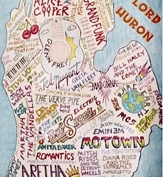
Musical Michigan
This Michigan music-maker meme has been rattling around social media in recent weeks, although I think the name-change on that big wet spot east of the mitten was a recent addition.
I actually learned a couple of things by Googling some of these names; for example. Bill Haley (of Bill Haley and the Comets) was born in Highland Park and that Del Shannon ("Run, run, run runaway...") was born Charles Weedon Westover in Grand Rapids.
I was dismayed that the Upper Peninsula was omitted from yet another map. I don't know of any famous musicians with U.P. connections, but there must be some.
18 notes
·
View notes
Note
Hey Dru, now you've started posting Her Countenance was Light, I have some questions to ask about it if you're up for it.
What was the initial inspiration behind this AU?
Where, geographically is Toreguarde roughly? Asking that only because you have his royal pain in the backside being from Iceland and I'm curious.
Looking forward to reading through this one once I have a spare minute xx
Heya 😊️
What was the initial inspiration behind this AU?
Uh. I genuinely don't remember.
So I jumped backwards in the document, thinking I might have put some notes, but apparently I started that NaNo off with the background of Old Red, as the doc starts:
It began, as these things often do, with fire.
Apparently I finished that in a day though, and started on Her Countenance was Light by writing the memory/ dream. Knowing me, I just had a flash of a scene and then took off from there 😅️
I will say though, I do like Film Noir-esque, detective and police-procedural stories. Max Payne (2008), The Bone Collector (1999), Sin City (2005 & 2014) and The Watchmen comic & movie could all be considered inspirations for this.
Are they directly responsible for this though? No idea, sorry 😅️
Where, geographically is Toreguarde roughly?
Somewhere on the upper east coast of the USA.
*opens a map* *jabs a finger at it*
IDK, like Vermont or New Hampshire, that kind of way, on that big-ass peninsula from New Brunswick down to Pennsylvania.
Canonically, Allansia is supposed to be "the new world" (to the point where the other continent that isn't Khul is called The Old World. GG Livingstone and Jackson) so it made sense to me to put it in N.America. I think I had this faint idea it should be a stand-in for New York 😅️ But I'd rather it be open to interpretation.
Re: Fangthane becoming Iceland - in this rewrite I did toy with the idea of changing it over, but ultimately I like the concept of Iceland being the kingdom, and Fangthane itself being the capital, or something. Mostly I chose Iceland for its remoteness as an island nation and norse heritage. I don't think it would have had the same effect if I'd plopped it in the Rockies.
Thanks for the questions, hopefully you found the answers interesting 😊️
#answered ask#aquadestinyswriting#meta writing#WIP 'Her Countenance was Light'#titan fighting fantasy#fighting fantasy#ttrpg fanfiction#meta wandering words
2 notes
·
View notes
Text
SOLAR ECLIPSE
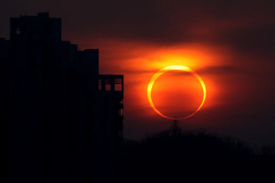
On October 14, 2023, a solar eclipse with a "ring of fire" will occur in a western strip of the United States, as well as in parts of Central and South America. The Moon, which will look a little smaller, will block the Sun by producing a bright red ring in the sky. This phenomenon, known as annular solar eclipse, was last seen in Spain in 2005 and will not be visible again on the Peninsula until January 26, 2028
How and where can you see the "ring of fire" of the eclipse?
The eclipse can be seen, even partially, from the 48 major U.S. states (all but Alaska and Hawaii) will have a partial eclipse, but only certain parts of some western states such as Oregon, Nevada, Utah, Arizona, New Mexico, and Texas will get the full "ring of fire" effect.
In some Central and South American countries, including Nicaragua, Panama, Colombia, and Brazil, the annular eclipse can also be seen. Maps created by NASA show the route where the ring of fire and schedules will be visible to better view it.
However, without eye protection, serious damage could occur in an instant,
Living the eclipse
The most notable effect of an annular solar eclipse is undoubtedly the spectacular burning ring seen in the sky, but viewers can also experience it with other senses. When the Moon blocks the Sun you will feel that the temperature drops and that it rises again when the Moon stops being in front of the Sun.
It is also possible how nature, especially animals, reacts to the disappearance of the Sun.
Eclipses also affect the upper part of the Earth's atmosphere, the ionosphere. As the Sun's radiation decreases, the density of electrons is reduced, even creating holes in which there are no, causing anomalies in communications and navigation, especially in radio and GPS.
2 notes
·
View notes
Text
The apartment search website Abodo created a map outlining the most racist areas in the nation. The site used software that tracked over 12 million tweets posted in 2014 and 2016, filtering out tweets with racial slurs.
Based on these findings, West Virginia was revealed to be the most racist state. Maryland and Louisiana were also the most racist states based on racial slurs used on Twitter.
---------------------------------
Most Racist States [Updated May 2023]
Racism is defined as prejudice or discrimination against people of different races. A racist person believes that his or her race is superior, while other races are inferior. While Americans might think that racism is most prevalent in the United States, it is considered more welcoming and accepting than many other countries. Some of the most racist countries are Bahrain, Lebanon, India, South Africa.
Racism in a given area isn’t something that can be measured like population or area. Polls and surveys can be used, but these aren’t always accurate. Other data, such as instances of hate crimes and hate speech, can also be used to determine where racism is most prevalent.
Because of this, it’s difficult to measure what states in the U.S. are the most racist. However, some organizations and publications have attempted to measure racism throughout the United States. The following contains some of these findings.
Arizona - 75.16
Hawaii - 74.48
Texas - 74.08
Montana - 73.95
Maryland - 72.84
New Mexico - 72.80
Wyoming - 72.77
Alaska - 72.46
Washington - 72.43
Georgia - 72.35
Kentucky - 71.44
Delaware - 71.28
Idaho - 69.92
West Virginia - 69.45
Virginia - 69.19
Florida - 69.08
North Carolina - 68.18
Colorado - 68.06
Tennessee - 67.77
Nevada - 67.71
Vermont - 65.86
Rhode Island - 65.80
Oklahoma - 65.54
California - 65.30
Indiana - 64.37
Missouri - 63.88
New Jersey - 62.84
Alabama - 62.72
Kansas - 62.11
Connecticut - 61.80
Utah - 61.68
Arkansas - 61.62
Massachusetts - 61.12
Mississippi - 60.55
Oregon - 60.22
New Hampshire - 59.95
South Carolina - 59.88
New York - 59.74
Maine - 59.73
Ohio - 57.66
North Dakota - 55.99
Michigan - 55.32
Nebraska - 54.91
Pennsylvania - 54.69
Louisiana - 54.18
Illinois - 53.13
South Dakota - 52
Minnesota - 49.84
Iowa - 44.68
Wisconsin - 33.01
DC - 28.36
Another study was conducted by data scientist Seth Stephens-Davidowitz using Google search data. Based on this data, the study found that the most racist regions in the United States are the rural Northeast and South, which were slave states before the American Civil War.
Searches containing racial slurs were most prevalent in the Appalachian region from Georgia to New York and Vermont.
High concentrations of racist searches were discovered in areas along the Gulf Coast, the Upper Peninsula region in Michigan, and Ohio.
However, it is important to note that these findings aren’t an official ranking of racist states. These studies give some idea of areas in the nation where racism may occur. Some of the states that have made the most racial progress are New Mexico, Hawaii, and Wyoming.
Here are the 10 states with the highest total racism scores:
District of Columbia - 28.36
Wisconsin - 33.01
Iowa - 44.68
Minnesota - 49.84
South Dakota - 52
Illinois - 53.13
Louisiana - 54.18
Pennsylvania - 54.69
Nebraska - 54.91
Michigan - 55.32
#most racist states ranking#50 states#us states racism index#racism by state#us racism#racism in the us#racism in us states list
3 notes
·
View notes
Photo
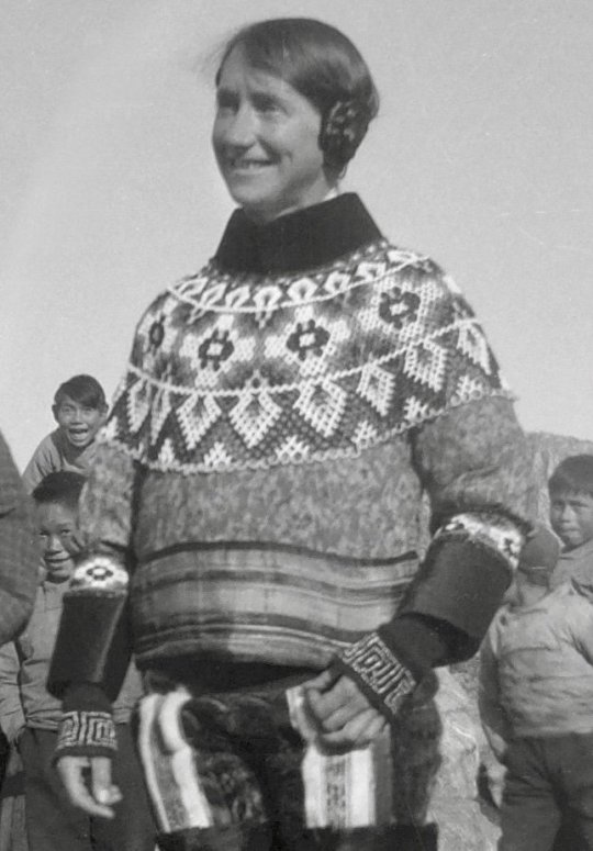
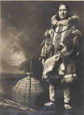
30th May 1889 saw the birth near Kirkliston of Isobel Wylie Hutchison.
Isobel Wylie Hutchison was an Arctic traveller during the 1920s and 1930s. She was also a botanist, a writer, a poet, an artist and speaker of numerous languages, so a bit of a polymath.
Carlowrie Castle a Scots baronial mansion was the comfortable upper-middle class home into which Isobel Wylie Hutchison was born in 1889. It was there her father, Thomas Hutchison, a successful wine merchant in Edinburgh, looked after his gardens, and passed on to Isobel his fascination for plants and his habit of meticulous note-taking. Although called a castle, Carlowrie was built between 1852 and 1855, so was never a defensive structure, but a luxurious home.
Isobel’s father, Thomas Hutchison, was a successful wine merchant in Edinburgh, he was a keen gardener and passed on to Isobel his fascination for plants and his habit of meticulous note-taking.
From 1917-18, she studied at an agricultural college, after which, she visited a number of countries around the Mediterranean region. But the sudden death or her father was subsequently followed by the loss of both her brothers. Isobel was left in a darkened place with a deeply grieving heart. Walking became her escape.
At a time when women were expected to stay at home, dressed in petticoats and tending to domestic duties, Isobel would often leave home for several days – much to the despair of her mother!
A Gaelic speaker, she had soon covered Scotland, including a trek from Blairgowrie to Fort Augustus, and began to look at bigger challenges. She wanted to spread her wings and fly away, and Iceland seemed like a good place to start.
Iceland, which she visited in 1925, was both a test and a revelation. She was told that she couldn’t walk the 260 miles north from Reykjavik to Akureyri because there were no maps, no guides, and it was far too dangerous. But she proved everyone wrong and then set her sights on another goal: Greenland.
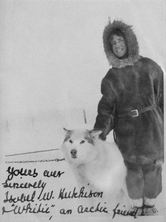
By now, Isobel was making a name as a traveller in the Far North. She had written books about her experiences in both Iceland and Greenland. However, she hadn’t quite finished her Arctic adventures! She made arrangements to travel to Alaska and Northern Canada to explore and again, collect plant specimens. In May 1933, Isobel left Manchester and went by ship, riverboat, train and also plane, to reach Nome in Alaska.
Eventually, she arrived in Barrow, in the north of Alaska, where she transferred to another small vessel before the Arctic Ocean ice began closing in, making it impossible to travel any further. Isobel was forced to stay in a migrant Estonian’s hut for many weeks until the weather situation improved. Although her journey had come to a halt, it was an opportunity for her to visit local Inuit families, walk, travel by dog sled and stay in igloos. Eventually, she continued her Arctic trip with a 120-mile dog sled journey and crossed over into Canada. After many months in the Alaskan and Canadian Arctic she eventually returned to Scotland, having been away for around a year.
Unable to obtain permission from the Soviet authorities to visit Eastern Siberia, Isobel’s next northern journey was in 1936, to the Aleutian Islands, off the coast of Alaska. This thousand-mile long archipelago of both large and small volcanic islands draped like a gigantic necklace between Alaska and the Kamchatka Peninsula in the far east of the USSR. These islands were inhabited by Aleut people on treeless terrain and were exposed to continuous windy, foggy and stormy weather.
The Aleut people of the islands were able to live in such extreme conditions because they managed to catch a range of marine life. Fortunately, she was able to visit many of the inhabited islands by way of US government vessels. Invariably, landing on the islands involved negotiating heavy seas in wild conditions. However, when she did make land, she met with the local inhabitants, generally explored and was able to collect her plants.
The onset of World War Two curtailed any plans for further journeys into the Arctic. After the war, she completed a number of long treks, including walking from her home in Scotland to London, from Innsbruck to Venice, and from Edinburgh to John O’Groats. Isobel Wylie Hutchison passed-away at her home in Carlowrie Castle in 1982, aged 92.
The Arctic journeys of Isobel Wylie Hutchison were extraordinarily daring during a time when such trips were unheard of for a single woman. She developed a real passion for the North as she explored various regions of the Arctic world. Isobel was a true adventure traveller, enjoying the uncertainty of her journey, taking calculated risks, but being utterly intrigued by all she saw in the Far North.
28 notes
·
View notes
Text
Michigan is weird and I love it.
Hi, hello, I am from Michigan. Or, as we tend to call it, I am a Michigander. And, I've realized that we're very, very weird compared to other states. So, here's a guide on how to blend in and pretend like you've lived here your whole life while visiting to see pretty lakes <3
We have weird slang. You'll see us using words like
Youper / Yooper
Noseeums (No/see/'ems)
The thumb
Traverse / Cherry City / Cherry Capital
Good gravy
Allow me to explain. Michigan is split into two parts; the Lower Peninsula and the Upper Peninsula. The LP is shaped like an oven mitten, and the UP is shaped like a sideways hand. This will be important later.

Up north, in the UP (pronounced "yoopee"), we have different accents, beliefs, and ways of living from the rest of us! I'm down in the LP, though, so I am not what we call a Yooper. Yoopers are the people living in the UP, who tend to rough it more, use less, and have their own accent, too! They're mostly known for their accent and how batshit insane they are /aff.
In the summer, we have loooots of bugs. Filmmakers love coming here, since we have so many "biomes" here. Beautiful and gross lakes, thick forests and barren sandscapes, stuff of the like. This means we have a very diverse ecosystem, including noseeums. Noseeums are tiny bugs you cannot see until they are right in front of you (~6 inches), or they buzz in your ear. They're actually called Fruit Flies, but you can't see them, so we usually call them Noseeums. Yoopers do this more than us down south.
Since Michigan looks like an oven mit, we tend to point at our hands to indicate where we are. The peninsula that sticks out if the LP we tend to call "the thumb," since, y'know, it looks like a thumb. The LP is the right hand, the UP is the left! Pinky and thumb sticking out, anyway.
Hey, if you wanna come visit us, I would highly recommend you go see Cherry Capital! It's a beautiful town with lots of resources, tourist-y things, and a great place to live. Oh, is it not appearing in Google Maps? Sorry, I meant Traverse City. We call it Cherry Capital since, according to Michigan rumor, it's the place that grows and sells the most cherries. Don't know how true that is, but y'know.
Good gravy, that's a lot of stuff. Oh yeah, we've got those too. Lick a tree for maple syrup, don't jump the salmon, lots of weird phrases. I can't remember all of them nor can I really explain them, except the two here. "Lick a tree for maple syrup" is a newer one (that I think was inspired by Tumblr, actually) that basically means that you're not putting in enough effort to get something. "Don't jump the salmon" is a variant on "look before you leap," because if you jump over the salmon swimming upstream, the bear will getcha.
oh yeah hug a moose is another one, too
We also have weird behavior. Like I said, you can use your hands like a map here. I keep forgetting that other people don't know this, and once I tried showing someone next to me n a plane while we were in Chicago, and she had no clue wtf I was doing. But, it's common practice here.
There's waaaaaay too many campsites, a ton of people go ice fishing (AND DRIVE TRUCKS ON THE LAKE AND DON'T FALL IN), lots of deer hunting, lots of deer signs. You have to know a lot of about wildlife here, like being aware of deer trails. If you don't know what those are, then you may be wondering why there are so many caution signs with deer on them.
oh yeah and all of it is "northern Michigan." no one says "Southern Michigan." I have no idea why.
Anyway. Fellow Michiganders, feel free to add to this. And other states that have weird traditions, too, I'd love to hear them.
8 notes
·
View notes
Text
peninsula
Steph’s working on a commission for Jill’s mom, the kind of Michigan woman who can’t get enough of Michigan-shaped art.
When Steph went to Jill’s parents’ house over the holiday break, she saw it for herself. Tons of Michigan prints on the walls, each saying things like HOMES and THE GREAT LAKE STATE. It almost makes Steph laugh. There’s pride in your home state, and then, there’s whatever this is. Like she’s trying to prove to guests she’s OK with never leaving Grosse Pointe (and who wouldn’t be?). Steph would judge her, but she’s paying her $70 to make a Michigan-shaped sculpture. So who is she to complain?
She puts on her favorite sculpting song: “Darkness on the Edge of Town.” She likes it because it reminds her of a movie she once saw, and that movie made her want to be an artist – made her want to make colors as pretty as the ones they immortalized there. As Steph sculpts, she thinks about what Jill’s mom said to her when she wrote the check.
Don’t bother with the Upper Peninsula, she said. I just think it would be an eyesore, don’t you?
Steph agreed then, if only for the $70. But she’s not so sure she meant it. She’s never been to the U.P., and when a Yooper transferred to St. Catherine’s in the middle of ninth grade, she joined in to poke fun at his not-quite-Canadian accent. Maybe she feels guilty about that. It would explain why she feels guilty about not sculpting the Upper Peninsula today.
What did the U.P. do that was so wrong? Is Jill’s mom just jealous because it looks like a dolphin? She’s a Michigan girl, but she’s a dolphin girl, too. Steph knew that as soon as she stepped into their downstairs bathroom (because they’re rich enough to have an upstairs, plus an upstairs bathroom). Maybe she just wishes she lived on top of a dolphin. Sounds about right when Steph thinks about it.
She looks at the map of Michigan – the one she’s used as a reference, despite having the mitten shape down to muscle memory. It almost makes her want to cry. There’s the U.P., all alone, not sure why no one wants to visit. It’s almost like they forget it’s still part of Michigan, after all. It’s like they don’t want to remember there’s anything up there.
She puts her hands on the clay and does what she’s told.
(part of @nosebleedclub june challenge -- day xxix!)
2 notes
·
View notes
Last Seen Blogs

littlelovelore
𝔩𝔦𝔱𝔱𝔩𝔢 𝔩𝔬𝔳𝔢

pellucid-constellations
for the lives i've dreamed

aoimybeloved
Yuu's Space

barrychannel131
Barry channel

ladyfantasy-art
Lady-Fantasy-Art