#world_map
Explore tagged Tumblr posts
Visit Tumblr Blog
Explore Tumblr blogs with no restrictions, modern design and the best experience.
Last Seen Tumblr Blogs


Fun Fact
In 2020, Tumblr had 29.4 million users in the US.
Text
Bring history into your home with this detailed 3D map relief model. This digital STL file depicts the R.Jalliot world map from 1964, surrounded by an elegant globe frame. Details: – File format: STL – Highly detailed 3D model with precision contours – File size: [not provided] – Designed for CNC routing/engraving – Compatible software: […] https://tinyurl.com/24an9pxh
0 notes
Text
Our maps will be useful for teachers and students, as well as for a wide range of users to expand their knowledge of the world's countries, their geographical position and features - both political and administrative and physical.
0 notes

Photo

The Map (WIP)
Valkyrie City
Hallow Wind
New Haven
Haven Harbor
Little Rock
White Wood
(A world I am trying to make, it was enjoyable to make this map)
3 notes
·
View notes
Photo

Download Interactive World Maps on Codecanyon
Description Interactive World Maps :
Download Interactive World Maps. The theme releases on Monday 3rd September 2012 By The author cmoreira on Codecanyon. It’s uses with clickable,countries,customizable,interactive,interactive maps,map,maps,metropolitan areas,plugin,regions,svg,wordpress,world,world map. Item Title: Interactive World Maps Category: wordpress/utilities Price: $29 Author: cmoreira Published Date: Monday 3rd September 2012 08:36:56 AM More Info / DownloadDemo
This is a Wordpress plugin to create as many maps as you want, with interactive and colored markers, continents, countries or regions. (Check out the standalone non-wordpress version here)
Show Different Regions
You will be able to show hundreds of different kinds of maps, already included:
A map of the entire world.
A continent or a sub-continent. (Africa, Europe, Americas, Asia, Oceania and all their sub-continents)
A country. (virtually all the countries in the world are included, featuring the most requested: USA, United Kingdom, Canada, France, Germany, Spain, Italy, Brazil, India, Australia…)
A country divided by its regions. *
A state in the United States.
The United States divided by metropolitan areas.
A state in the United States divided by metropolitan areas.
Color Regions or add Markers
You can add active colored regions to the map, and display them in 2 different ways:
As Regions – It will color the whole region, for example a continent, subcontinent, a country, a country province, or a US state.
As Markers -It will display a colored bubble in the chosen regions, that can be a city, a state or a country.
See the DEMO to see how they interact!
Add Interactivity
You can add interactivity to the active regions:
A Tooltip- A tooltip will be displayed by default on hover with the information you provide.
An Action ? You can set up diferent kinds of action for when the user clicks in an active area. You can make a new URL open, or simply display a message. Advanced users will be able to create their own Javascript functions for customized actions, like opening information with a lightbox effect.
Customizable
You will be able to costumize the visual of your maps:
Background color;
Box border width and color;
Inactive regions color;
Individual colors for each active region;
Markers size;
Width and Height of the map;
Add the Maps anywhere on your website
You can use a shortcode to include the maps in posts, pages and even in sidebar widgets! You can also add the maps to your template, with a simple php function.
Responsive
If no width is specified it will load with the maximum width available in the container div. For example, it will load and adapt with different sizes for phones/ipads/laptops. However, after loaded it will not change size if you resize the window. Since version 1.4 the plugin includes an option to make the maps fully Responsive. This will use jQuery to check if the window size changed and will redraw the map with the new available space.
Cross device and browser compatible
The maps are built in SVG, no flash is used and therefore they will display in Mac products.
CSS Hacks made easy
There a few features that the Google Geochart API doesn’t provide by default, but the plugin provides a ‘Custom CSS Generator’ to help implement some features like hover colour change effect, implement font icons as markers, change border colour, among others.
Example of map using font icons from fontAwesome toolkit using some CSS tricks, available from version 1.7.3 released January 2016. Learn more about this technique.
Where to use it?
This plugin is perfect for:
Travel Websites – Create maps to display destinations and link to pages about a specific location
Traveler Website – Display a map with destinations/countries visited
Multinational Companies – Create maps of the cities/countries where they operate
Small Companies – Show the location of the business in a country map
NGO’s – Create maps of NGO projects around the world
Infographics – Display simple to read maps with various information
And much more other applications! Be creative!
Compatible with all the popular WordPress Themes
Including:
Divi – by ElegantThemes
Avada
X Theme
This plugin uses the powerful Google Geochart API which creates the SVG vector maps. _
Featured in
Create Interactive World Maps with Wordpress – wpContent.co.uk
WPNuggets – Interactive World Maps Plugin Review
WPMU – 7 WordPress Map Plugins That Put The World At Your Fingertips
Tripwire Magazine – 75+ Best WordPress Plugins ? Want Unfair Advantage?
Item Collection – Great for Politics
Come creare mappe geografiche interattive e personalizzate (Italian)
Testimonials
«Absolutely love this plugin. Very easy to use and set up. Highly recommended to anyone looking for a mapping solution! Great job.» SBMAG
«This is the easiest to use plugin. I bought the plugin to use for a client?s site that does work all over the world. They wanted an easy way to display information about their work in different countries and this made my life so simple. Well worth the money and I?ll be back to purchase for any additional clients who need this type of functionality.» Benjamin Bradley
«If anyone is thinking about buying this plug-in, don?t hesitate. It doesn?t get any better than this. If you think $18 is too steep, you?ve never struggled coding maps. This is such a time saver that I?d gladly have paid ten times the asking price. In fact, I?ve paid a pretty penny for software over the years hoping to save time and aggravation when it came to making interactive maps. Interactive World Maps is a gem.» Mark
Notes
* The maps of countries divided by regions include the main regions of the specified country. The plugin calls all of them ‘Provinces’ but in reality they could be states, regions, provinces or counties, depending of the country. They are the first level of division of a country. In the particular case of UK, it only includes 4 regions (ENG, NIR, SCT and WLS). The maps of some small countries divided by regions are not available, since the country is too small (Malta for example). If you need to make sure a map divided by regions is available, contact us via the support tab.
Changelog
2020/04/27 - v.2.4.8 - Bug fixes on custom action, admin improvements 2020/03/16 - v.2.4.5 - Bug fixes on edit screen, code improvements 2019/01/20 - v.2.3.3.1 - javascript improvement, added 'projection' shortcode parameter support, custom icon image hand cursor fix, image in colorbox fix, first iteration of duplicate maps, better handling for iOS html tooltip bug; 2018/09/10 - v2.2.7 - shortcode render in lightbox, iframe colorbox mobile size fix, nowrap bug solved 2018/06/28 - v.2.2.3 - sanitize fields bug fix 2018/06/11 - v2.2.1 - Small bug fix related with the action to display content after marker or region is clicked. 2018/06/08 - v2.2 - show-map-image shortcode and populate automatically helper actions + bug fixes 2018/05/11 -v.2.1 - Added option to setup custom image as marker 2018/01/13 - v.2.0.5 - added action to display content on the right & new option in the settings to disable image preview 2017/09/19 - v.2.0.2 - php7 improvement on layers widget, added shortcode to display map title and description [show-map-title id='x'],[show-map-description id='x'], added iwm_input filter, tiny MCE update 2017/06/28 - v.2.0 - Improved ordering of countries for list and dropdown (now considers accents in region names). Other small improvements. 2017/04/06 - v.1.9.9 - CSS Improvements, marker size for mobile, no wrap option for tooltip 2016/11/03 - v.1.9.4 - CSS Improvements. Improved zoom code (still in beta). Improved show-map-list shortcode. 2016/07/22 - v.1.9.1 - Added option to add Google Maps API Key. Other small bug fixes. 2016/05/24 - v.1.8.5 - Editor improvements 2016/05/24 - v.1.8.4 - Javascript bug fix and CSS improvements. Implemented workaround for Google API bug 2016/05/01 - v.1.8 - Javascript bug fix that was preventing the maps from displaying in some browsers 2016/04/30 - v.1.7.9 - New Actions Added. Cornerstone integration. Hover code improved. 2016/02/07 - v.1.7.6 - Map widget & Layers widget, custom js field added, custom css generator hover option improved 2016/01/14 - v.1.7.3 - Added options to use font icons instead of markers 2015/11/12 - v.1.7.2 - Fixed PHP bug; Added hidden feature, shortcode parameter extras='dropdown' 2015/09/04 - v.1.7 - Visual Composer integration code updated 2015/07/01 - v.1.6.7 - Improvements in the javascript code that controls the responsive behaviour 2015/04/01 - v.1.6.6 - Added Kosovo; Custom CSS Box; Overlay map options; Added projection option; Added tooltip on click option 2015/01/20 - v.1.6.5 - Small Improvements for advanced usage; 2014/09/06 - v.1.6.1 - Small Improvements; New shortcode to display region entries as dropdown; 2014/06/13 - v.1.6 - Made the plugin Visual Composer Ready 2014/06/09 - v.1.5.6 - New Custom CSS option in Settings; Text Markers Mode implemented; 2014/05/04 - v.1.5.5 - https improvements / apply_filters( 'i_world_map_capability', 'manage_options'); implemented 2014/01/31 - v.1.5.4.1 - Small Responsive behaviour improvement. 2013/12/10 - v.1.5.4 - New admin Menu Icon (WordPress 3.8 compatible). 2013/11/03 - v.1.5.3 - HTML tooltips added. 2013/10/02 - v.1.5 - Improved Responsive feature; Improved javascript handling. 2013/06/03 - v.1.4 - Added feature to make the maps fully responsive [...] 2012/11/30 - v.1.3 - Added feature to disable tooltip 2012/10/18 - v.1.2 - Added feature to display markers inserting lat/lon coordinates 2012/09/22 - v.1.1.0 - Added feature to color continents and subcontinents. 2012/09/22 - v.1.1.0 - Added feature to color continents and subcontinents. 2012/09/09 - v.1.0.3 - Improved support for HTML values in 'action value' field. 2012/09/05 - v.1.0.2 - Google Chrome bug fixed, Improved function to show map from php function and other minor fixes. 2012/09/03 - v.1.0.1 - Minor fixes in the wp_enqueue 2012/09/03 - v.1.0.0 Initial Release
More Info / DownloadDemo #Interactive #World #Maps
#All_Code_amp_plugin#clickable#Code_amp_plugin_New_releases#countries#customizable#interactive#interactive_maps#map#maps#metropolitan_areas#New_releases#plugin#regions#svg#wordpress#Wordpress_New_releases#Wordpress_plugin#world#world_map
0 notes
Photo

World map. via /r/DesignPorn https://www.reddit.com/r/DesignPorn/comments/jcai3o/world_map/?utm_source=ifttt
1 note
·
View note
Photo

Quito, Ecuador
August 2013
0 notes
Photo

World Maps Lovers Collection with all designs from old world maps, colorful world maps, vintage/ retro world maps, watercolor world maps to make special unique gift for you, your friends, your family, your boss, for travelers, for traveling lovers, for world map lovers. . Custom your own family, parents, dad, mom artwork, design, photo, illustration with World Maps Lovers Collection . Check out link now https://www.zazzle.com/collections/world_maps_lovers_collection-119665942787675235?rf=238478323816001889&tc=FamilyGryponsTum ,
0 notes
Text
WCA #216 with Adam Gonsalves
Working Class Audio #216 with Adam Gonsalves!!!
Adam Gonsalves has mastered over a thousand releases from artists around the world. He is equally at home mastering for digital formats and cutting lacquers for vinyl. Prior to mastering Adam worked for 7 years as a tracking and mixing engineer at Anchorhold Recording. From 2010-2013 Adam also produced the Square Cad Mastering Podcast. In 2017 he was featured in the book Why Vinyl Matters. Adam received a master’s degree in Music Technology from New York University. Adam is approved to provide Mastered for iTunes masters. Clients include: Willie Nelson, Peter Buck, Elliott Smith, Sleep, Blitzen Trapper, The Last Artful Dodgr, Sufjan Stevens, Pure Bathing Culture, Tender Loving Empire, Southern Lord, TKO, Living Music, Crane City Music, Typhoon, My Brightest Diamond, Dead Moon, Emma Ruth Rundle, Steve Aoki, Poison Idea, Rogue Wave, Ty Segall, Pelican, John Craigie, Earth, Horse Feathers, Blackwater Holylight, Calvin Johnson, Haley Heynderickx, Widowmaker, and many more. Additional credits available at Sound Credit.
About this Interview:
Adam joins me to talk about the Square Cad Mastering podcast, interrogating your own workflow, his journey into lacquer cutting and his work/life balance. -Enjoy
Show Notes and Links
WCA Patreon Subscriptions: http://www.patreon.com/workingclassaudio
Telegraph Mastering: http://telegraphmastering.com/
Square Cad Mastering Podcast: http://squarecad.net/
Audio-Technica: https://www.audio-technica.com/world_map/
UA Promo: https://www.uaudio.com/uad-accelerator-promo
AEA Ribbon Mics: https://www.aearibbonmics.com/
Audio Life on Gearslutz: https://www.gearslutz.com/board/audio-life/
WCA on Youtube: https://goo.gl/g5nsWG
Check out this episode of Working Class Audio
#audio#WCA#Working Class Audio#Mixing#Recording#producers#engineers#sound#live sound#game sound#interviews#audio pros
1 note
·
View note
Text
They include such types as: political maps, administrative maps, country location maps on the world map, physical maps, road maps, tourist maps…
0 notes
Photo

Earthy World Art Print- 11x14 in, Travel Art, Map Artwork, Watercolor Painting, Simple Design 20 Go now: https://greatlakesmade.com/marketplace/earthy-world-art-print-11x14-in-travel-art-map-artwork-watercolor-painting-simple-design/?feed_id=5879&_unique_id=5eb5850b16b71&utm_source=Tumblr&utm_medium=shelbykregel&utm_campaign=FS%20Poster Discover more from Shelby Kregel by visiting the link in our bio. #art #earth #earthy #gallery_wall #map #natural_tones #painting #prints #shelby_kregel #simple #travel #watercolor_print #watercolor_world #world #world_map
0 notes
Photo
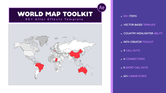
Download World Map Toolkit After Effects project on videohive
Description World Map Toolkit :
Download World Map Toolkit. The project releases on Monday 1st March 2021 By The writer footag on videohive. It’s Tagged with animated Call Out,animated linear icon,flight map,Tourist Destination,travel map,Travel path maker,weather map,World Animated Map,world countries highlighter,World country indicator,world flight map,world map. Project Title: World Map Toolkit Category: after-effects-project-files/infographics Price: $29 Creator: footag Publish Date: Monday 1st March 2021 02:45:21 PM More Info / Download
World Map Toolkit
animated World Map with Country highlighting ability, 4 Different animated travel path definer tool, 23 animated call outs & 60+ animated linear map icons that give you the ability to create all kinds of infographics World map animation, statistics World map, weather map animation, travel world Map and much more in After effects is an answer to your needs. world map toolkit is a simple After effects tool that surprise you with its capabilities such as selecting each country animation, making statistics map animation, travel path animation & 60+ useful animated map icons & convert the making animated map in aftereffects to an enjoyable work
Very easy to use even for you
one of the most important features of this template is the simplicity of working with it .for example you are a YouTuber, you just need After effects on your pc or mac. even you are a beginner in After effects you can easily create your animation content. everyone can use this template even you
Country Highlightable Map
you have great controls that help you to highlight each Country with your own color. you just select your own color and select your desired Country. after the map revealed in countries are highlight automatically
Path creator toolkit
you can create a different(two points, three points, four points & five points) travel path animation on the map with the path creator toolkit. just you adjust the points on the map. also one of the wonderful features is the ability to change the icon. you can choose one of the linear icons such as airplane icon, ship icon, bus, map markers, map pin & much more…. you can adjust the travel animation duration to your own time easily with a slider controller.
Short Call Outs
Short call out is one of the most useful parts of the “World Map Toolkit” that you can use in each After effects project separately. the outstanding feature of the shorts call-outs of this template than the others is that when you change the call-out text, the size of the call-out shape adjusts with your text size automatically. you just type your text without worries about crossing borders.
. Statistical short callout
With this small and useful tool, you can present your statistical information on maps you just put it on your maps & set your data with a simple slider. finally, you have a simple & beautiful statistical map.
. Icon callout
icon call out is one of the wonderful parts of this template you can change the icon with icon selector and choose one of the 63 linear animated icons.
linear animated icon
there are 63 linear animated map icons that include different animated icons such as weather, vehicles, people, map markers, Public places & much more. you can change the line size & color easily
Callouts & Connections
9 big call out that helps you in giving more information to your subject. also with connections, you can connect two or more points together.
Features
Ae CC 2018 & above
No plugins required
Resizable Template
Full Hd 1920×1080
Universallized expressions(Working with each language version of Ae)
Fast render
Vctor Based Template
Includes video tutorial
90+ useful elements for After effects
Each country highlight ability
Path creator toolkit with 4 paths
Icon selector for path toolkit with 63 linear animated icons
8 Short call Outs with auto text adjust ability
9 Title call outs
6 Connections
Music Link
just-ad-ukulele More Info / Download #World #Map #Toolkit
#After_Effect#after-effects-project-files_Rising_stars#All_Video#animated_Call_Out#animated_linear_icon#flight_map#Rising_stars#Tourist_Destination#travel_map#Travel_path_maker#Video_effects_Rising_stars#weather_map#World_Animated_Map#world_countries_highlighter#World_country_indicator#world_flight_map#world_map
0 notes
Text
youtube
Dope Tech of CES 2018 Pt. 1
Another year, another Consumer Electronics Expo bringing plenty of gear porn to the public. Marques Brownlee walked the Vegas expo floor so that we don't have to, and shared all the tech he deems dope, and some of it is really, really dope.
Razer's Project Linda is definitely interesting.
The concept is an ultraportable laptop design powered by the Android-based Razer Phone. The docked phone serves as an intelligent touchpad, bridging the gap between handheld entertainment and laptop convenience. The Razer Phone’s performance, display, and dual front-firing speakers combine seamlessly with Project Linda’s larger screen, keyboard, and battery to provide the ultimate mobile hybrid setup for gaming, creativity, and productivity.
Sennheieser's godlike HD 820
With these groundbreaking closed dynamic headphones passionate music lovers can now enjoy their music at an audiophile level wherever they please, at home or on the move. Featuring unique glass transducer covers that minimize resonances, the HD 820 are simply the most transparent-sounding closed headphones in the world, extending the boundaries of what has been achieved in sound reproduction with closed type headphones up to now.
At a cool $2,399.95, these will remain on my list of absurd things I wish I could afford, for now.
Other mentions are the much improved HTC Vive Pro and the TPCAST Wireless Adapter that plugs into the Vive/Vive pro/Occulus, allowing you to walk around wirelessly, untethered in VR Chat. Also some cool speakers and a sub-woofer from Razer, a ton of new audio gear from Audio Technica, the king of all drones at the Yamaha booth, and a self-balancing motorbike that looks like Akira should be riding it had me foaming at the mouth. DJI had some cool stuff too, including the new Osmo 2 mobile gimbal with an attractive price of around $150-$200
youtube
Dope Tech of CES 2018 Pt. 2
Synaptics debuted their under-the-glass fingerprint reader tech, which will probably become standard this year or the next. Other mentions include a uniquely futuristic tv concept from LG which rolls the screen down into a box at its base, allowing a simple solution for hiding your tv from view at will, if that's your thing. We also saw Samsung's 146" modular OLED display, Sony's massive 85" 8K HDR display, some neat Apple-style third party keyboards, lots of self-driving car concepts, and Omron's self-learning AI powered ping pong robot. Cool.
Bonus: Laundroid, the machine that may one day fold your laundry with AI, nueral networks, and deep learning
We're outpacing ourselves with tech, folks. What a time to be alive.
0 notes
Link
0 notes
Text
4月19日資料4
食の場をテーマに扱うということで、食��関連したサービスについて、どのようなものがあるか調べたことをまとめました。(まとめ:西・岩舘・秋山)
〇レストランの紹介
・大阪のダイニングバー。プロジェクションマッピングでサプライズバースデー演出。小人がケーキを作ってくれる。※1日1組限定 4500円。
・銀座にあるスペイン料理の飲⾷店。この店も記念⽇のサプライズに使われる。テーブルや周りのスペースだけでなく、エントランスからプロジェクションマッピングを使っている。臨場感を高めるために(振動スピ ーカーを使って)テーブルから⾳が出るようにしているのは参考したい。
・六本木のレストラン。夜景、空の上、海の中などが映し出される店内フルプロジェクションマッピング。お店を紹介のサイトによると日本初とのこと。来るたびに内装が変わる。記念日や誕生日などにサプライズの演出としても使われる。持ち込んだ写真や動画でも映し出すことができる。
・スペインにあるレストラン。この店のプロジェクションマッピングは内装だけでなく、料理のお皿までプロジェクトでデコレートしたり、料理に合わせて部屋を変化させたりする。さっき紹介した日本にある3つの店は一人5000円前後だが、このお店はミシ��ラン二つ星のシェフが運営してるため、1 回のコースで一人 22 万円(!)ほどの値段がかかる。最大12人が利⽤できる。狭いがその代わりに素晴らしい演出が堪能できる。
〇参考になりそうな点
・銀座のダイニングバー→臨場感を⾼高めるためにテーブルから音を出す。教室の⼊り口に何かもの(木など)を置いて、そこにもプロジェクションマッピングで映し出すことも考えられる。
・六本木のレストラン→教室全体に様々な風景を映す。(プロジェクターの台数の関係で実現できるかは不明)
〇食神様の不思議なレストラン:https://tabegamisama.com/
〇泳ぎ寿司
宮城県の石巻市では 3 月に東京と大阪で食育体験プログラムとして行われた。このプログラムでは三陸沖で収穫された海産物が出荷されて寿司として消費 者に提供されるまでの過程をプロジェクションマッピングで疑似体験させるものである。 目的は東日本大��災における震災の風評被害の払拭や、食材に対する安心感、食に対する正確な情報を学んでもらうことである。 プロジェクションマッピングの内容は実際に石巻の寿司職人がお寿司を握り、握られた寿司がプロジェクションマッピングの技術を用いて寿司の板にプロジェクションマッピングで投影され、泳ぐ魚に変化して生育環境のアニメーションで紹介される。 モーションセンサーを活用して、体験者の動きに応じて様々なインタラクションを体感できる仕掛けも用意されている。 食べて、触って、見て、聞くことによって来場者は五感を通じた体験から、石巻の食を知る事ができる。
〇食についてのサービスにどのようなものが求められているのかの考察
紹介したレストランではプロジェクションマッピングによって食事と共に演出も楽しめる空間になっているので、レストランでのサービスについては、お客が飽きない演出が求められていると思う。今回作るプロジェクションマッピングでも、対象者や発表会の来場者が飽きない工夫を考えるといいかもしれないと思う。
参考文献
・大阪(⼩人のケーキ)「MONTEREY」 https://www.hotpepper.jp/strJ001161408/appearance/
・銀座(エントランスもプロジェクションマッピング)「CASA AfeliZ GINZA」 https://www.atpress.ne.jp/news/91506http://www.casaafeliz.com/ https://www.youtube.com/watch?v=EinGkEeLsgo https://www.youtube.com/watch?v=5cIkSefT6Gw
・六本⽊木(内装が変わる)「Barliminal」 http://www.barliminal.com/https://www.hotpepper.jp/strJ001146798/
・スペイン(22万のサービス)「Sublimotion」
http://projection-mapping.biz/world_mapping/sublimotion_161024.html http://www.sublimotionibiza.com/#!homehttps://www.youtube.com/watch?v=ifgPVdvM-2Ihttps://www.youtube.com/watch?v=IElE29HFTEk
0 notes
Text
4月19日資料4
食の場をテーマに扱うということで、食に関連したサービスについて、どのようなものがあるか調べたことをまとめました。(まとめ:西・岩舘・秋山)
〇レストランの紹介
・大阪のダイニングバー。プロジェクションマッピングでサプライズバースデー演出。小人がケーキを作ってくれる。※1日1組限定 4500円。
・銀座にあるスペイン料理の飲⾷店。この店も記念⽇のサプライズに使われる。テーブルや周りのスペースだけでなく、エントランスからプロジェクションマッピングを使っている。臨場感を高めるために(振動スピ ーカーを使って)テーブルから⾳が出るようにしているのは参考したい。
・六本木のレストラン。夜景、空の上、海の中などが映し出される店内フルプロジェクションマッピング。お店を紹介のサイトによると日本初とのこと。来るたびに内装が変わる。記念日や誕生日などにサプライズの演出としても使われる。持ち込んだ写真や動画でも映し出すことができる。
・スペインにあるレストラン。この店のプロジェクションマッピングは内装だけでなく、料理のお皿までプロジェクトでデコレートしたり、料理に合わせて部屋を変化させたりする。さっき紹介した日本にある3つの店は一人5000円前後だが、このお店はミシュラン二つ星のシェフが運営してるため、1 回のコースで一人 22 万円(!)ほどの値段がかかる。最大12人が利⽤できる。狭いがその代わりに素晴らしい演出が堪能できる。
〇参考になりそうな点
・銀座のダイニングバー→臨場感を⾼高めるためにテーブルから音を出す。教室の⼊り口に何かもの(木など)を置いて、そこにもプロジェクションマッピングで映し出すことも考えられる。
・六本木のレストラン→教室全体に様々な風景を映す。(プロジェクターの台数の関係で実現できるかは不明)
〇食神様の不思議なレストラン:https://tabegamisama.com/
〇泳ぎ寿司
宮城県の石巻市では 3 月に東京と大阪で食育体験プログラムとして行われた。このプログラムでは三陸沖で収穫された海産物が出荷されて寿司として消費 者に提供されるまでの過程をプロジェクションマッピングで疑似体験させるものである。 目的は東日本大震災における震災の風評被害の払拭や、食材に対する安心感、食に対する正確な情報を学んでもらうことである。 プロジェクションマッピングの内容は実際に石巻の寿司職人がお寿司を握り、握られた寿司がプロジェクションマッピングの技術を用いて寿司の板にプロジェクションマッピングで投影され、泳ぐ魚に変化して生育環境のアニメーションで紹介される。 モーションセンサーを活用して、体験者の動きに応じて様々なインタラクションを体感できる仕掛けも用意されている。 食べて、触って、見て、聞くことによって来場者は五感を通じた体験から、石巻の食を知る事ができる。
〇食についてのサービスにどのようなものが求められているのかの考察
紹介したレストランではプロジェクションマッピングによって食事と共に演出も楽しめる空間になっているので、レストランでのサービスについては、お客が飽きない演出が求められていると思う。今回作るプロジェクションマッピングでも、対象者や発表会の来場者が飽きない工夫を考えるといいかもしれないと思う。
参考文献
・大阪(⼩人のケーキ)「MONTEREY」 https://www.hotpepper.jp/strJ001161408/appearance/
・銀座(エントランスもプロジェクションマッピング)「CASA AfeliZ GINZA」 https://www.atpress.ne.jp/news/91506 http://www.casaafeliz.com/ https://www.youtube.com/watch?v=EinGkEeLsgo https://www.youtube.com/watch?v=5cIkSefT6Gw
・六本⽊木(内装が変わる)「Barliminal」 http://www.barliminal.com/ https://www.hotpepper.jp/strJ001146798/
・スペイン(22万のサービス)「Sublimotion」
http://projection-mapping.biz/world_mapping/sublimotion_161024.html http://www.sublimotionibiza.com/#!home https://www.youtube.com/watch?v=ifgPVdvM-2I https://www.youtube.com/watch?v=IElE29HFTEk
0 notes