#Basic Geography
Explore tagged Tumblr posts
Visit Tumblr Blog
Explore Tumblr blogs with no restrictions, modern design and the best experience.
Last Seen Tumblr Blogs


Fun Fact
Tumblr has been providing a Korean-language service since 2013.
Text

the poor children
#something about survivor's guilt#deltarune#kris dreemurr#noelle holiday#utdr fanart#utdr#fanart#deltarune fanart#digital art#kris deltarune#noelle deltarune#dess holiday#i mean kinda???? dess is basically implied here#also i 100% rushed this because i have a geography test tomorrow i haven't studied for BYE#my art
658 notes
·
View notes
Text
This is a very long post. If you do not have the time, then please at least do the quick activity up top. The lesson plan that took me 4 days to write will follow the ⁜ symbol.
HW Due Mon:
Open https://mysolartime.com/ in a new tab and allow the website to track your location.
Open https://www.utctime.net/ in a new tab.
Reblog this post the current UTC time and your local time, using the following format:
21:00 UTC, 4:00 local
4. Vote in the following poll.
⁜
Social Studies, Grade 5, Geography 6.1.5.GeoSV.3: Demonstrate how to use digital geographic tools, maps and globes to measure distances and determine time zones, and locations using latitude and longitude.
Do Now:
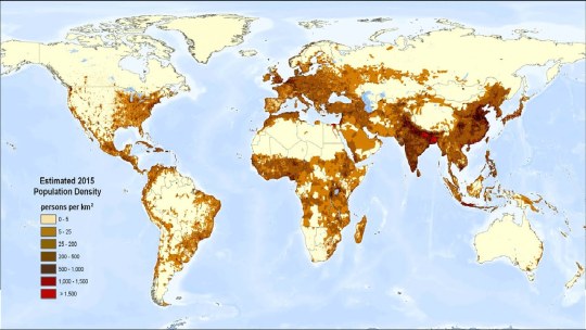
Provide students with a paper copy of a population density world map and 2 minutes to fulfill the following instruction:
Draw lines on the map in order to separate the world into 24 time zones. Try not to separate dense population centers into different time zones.
⁎
Class Discussion:
Use the projector to share and discuss the maps of any students who are willing to share. Have fun with this, there are bound to be some good ideas and bad ideas because 5th grade is like that.
Then, project the official world time zone map, and discuss the good ideas and bad ideas present here.


Exemplary discussion points:
The 0-point of the timezone map is the Prime Meridian, which cuts right through England. Why do you think it's in England?
How come some countries like the US and Brazil are cut into multiple time zones, but China isn't?
Why do you think the lines are pretty straight in Europe, Africa, and North and South America, but so confused in Asia and the Atlantic and Pacific Oceans?
⁑
Direct Instruction:
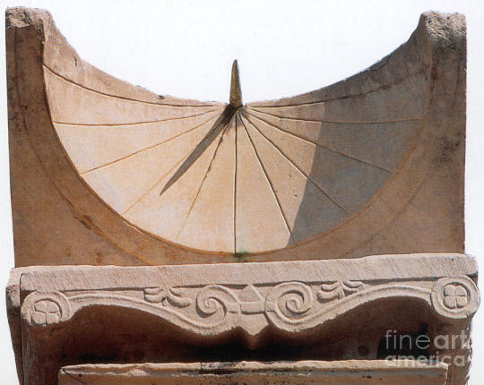
Long ago, nobody really cared about the exact time. All you really needed was sunrise, sunset, and noon, and you could figure those out with your eyes. If you wanted to be fancy, you could put a stick in the ground and trace its shadow over the course of the day to measure out hours.
Perhaps the first recorded complaint of time-keeping technology comes from Rome in 250BCE.
The gods confound the man who first found out how to distinguish hours! Confound him too Who in this place set up a sundial To cut and hack my days so wretchedly Into small portions! When I was a boy, My belly was my sundial: one more sure, Truer, and more exact than any of them. This dial told me when it was time To go to dinner, when I had anything to eat; But nowadays, why even when I have, I can't fall-to unless the sun gives leave. The town's so full of these confounded dials, The greatest part of its inhabitants, Shrunk up with hunger, creep along the streets. [x]
In other words, "Kids these days are always looking at their sundials. Back in my day, there were only three times, Breakfast, Lunch, and Dinner. All we needed to tell the time was our stomach!"
Please note this was a satire, so if it sounds funny, you are correct.
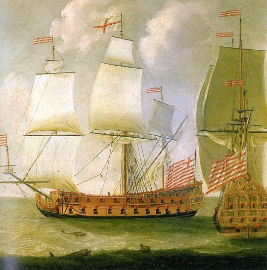
But for 18th century British sailors, accurate timekeeping was no laughing matter. These sailors used fancy math (called trigonometry) to calculate their latitude. So long as they knew the angle between the sun and the horizon, and the time when that angle was measured.
Ship's captains would keep logbooks of these measurements. That way, another ship's captain would be able to reference the logbook in order to replicate the journey, much like replicating a science experiment.
Now... think about this... how can you do that unless the next captain is using the same time as you. We take this for granted today, but how can you be sure that two clocks are synchronized?
Scientists in the town of Greenwich, England (pronounced gren`-ich) recorded the solar noon every day of the year and calculated the Greenwich Mean Time. By keeping an accurate and exact time in one exact place, GMT eventually the Coordinated Universal Time (UTC) for everyone in the world. That's why in the time zone map, the 0 runs through one specific part of England.

This is important. For the first time in human history, the clocks in different places were synchronized. Solar noon happens at a different time in London than it does in Greenwich, but if they both use GMT (otherwise known as UTC), then they can coordinate their schedules. This was very important for railroads, where exact, coordinated schedules are very important.
Soon, the entire country of England existed within a single time zone.
When the United States built railroads that spanned vast lateral (East-West) distances, they needed to create different time zones for cities that were far apart from each other, such as New York and Chicago. Thus, the US became the first country with multiple time zones.
As the rest of the world industrialized, they needed to pick their time zones. You can see this on the map. Each time zone is, at least in theory, as wide as 1/24 the circumference of the Earth. It's like the space between the numbers on a clock! Most countries are smaller than this, so they can comfortably fit within a single timezone. Others, like Brazil and Australia, divided their landmasses into two or three time zones.
China did not have widespread industrialization until post-WWII dictatorial communist rule. This was a very uncaring and inconsiderate government, to put it mildly. Suffice it to say that for Chinese farmers in the far west, having to get up 2-3 hours earlier every day would have been the least of their worries.
⁂
Modeled Activity:
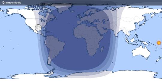
Show students how to use this Day and Night world map as a way to visualize the day and night cycle across the world.
Additionally, show them how to use https://mysolartime.com/ to find their current time where they live.

Give students a moment to calculate the difference between their Local Time and the official time in their time zone, and what that means.
(I am currently in Philadelphia, which is 11 minutes East of New York City)
Finally, show students how to use https://www.utctime.net/ to find their exact, current UTC.

Have students calculate the difference in minutes and hours between Local Time and Official Time.
00:41 - 19:30 = -5:11 (Philadelphia is 5 hours and 11 minutes East of Greenwich, England)
Explain that every internet connected device in the world uses a service like this one, then adds or subtracts hours to fit the time zone of your current location.
Higher Order Learning:
Students work in small groups to look up the local time in different major cities around the world, recording their data on a worksheet. As they do, they should discuss the following questions:
Are time zones still relevant in our always-online society?
If you can know your Local Time and the UTC any time you look at your phone, then what purpose do time zones still serve?
How would it feel for schools and businesses to use UTC instead?
How would you feel if your school day went from 4:20-10:50 UTC?
Finally, each student must individually write at least 3 sentences responding to the following question:
Would you advocate for or against your school district dropping references to the time in your time zone and instead referring to UTC and Local Time? Why or why not?
#lesson plan#social studies#grade 5#geography#poll#polls of tumblr#tumblr poll#teachblr#I JUST WANTED TO ASK A QUESTION BUT I KEPT ON RAMBLING IN THE NOTES AND THEN I WAS LIKE “THIS IS A LESSON ISN'T IT”#AND THEN I SPENT THE NEXT 3 DAYS DOING BASICALLY NOTHING WITH MY FREE TIME EXCEPT RESEARCHING AND WRITING THIS LESSON#I HOPE YOU ALL LEARN SOMETHING BECAUSE I DID
120 notes
·
View notes
Note

isn't that just south canada
77 notes
·
View notes
Text
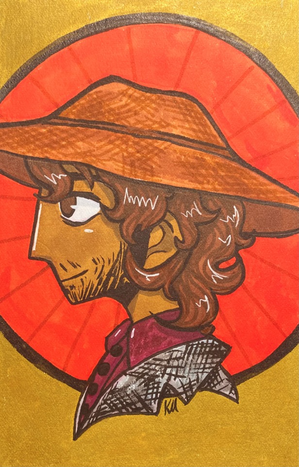
Yeehaw it’s my favourite western character Texas man from British vampire gothic horror by famous Irish guy
#I made this awhile back and was waiting for a big Quincey day to post this but fuck it I love how this turned out#quincey morris#quincey p morris#dracula#dracula daily#re dracula#re: dracula#Art#traditional art#artwork#illustration#markers#alcohol markers#lol I’m actually a huge western enjoyer (but no one else around me is so I basically have no interaction with the genre :( )#I used to find the southwest as a setting boring but then my family dragged me out to Utah and Arizona and something just clicked#Like. Oh. These are beautiful vast areas with a stunning geography and a vibrant history and culture#And out west 110 Fahrenheit feels like 80 Fahrenheit which was crazy to me (I made sure to wear a lot of sun protection)#I also realized I was gay and that played into it
197 notes
·
View notes
Text
for a site claiming to be full of former gifted kids yall are dumb as hell
#apparently we're going through the annual “wait other countries exist wow they don't teach us anything” posting cycle#world geography is a class we have to take#and even if somehow you didn't just basic thinking should get you there#♡
105 notes
·
View notes
Text
first of all start getting it right it's colOmbia COLOMBIA not Columbia, colUmbia is one of your shitty fifty trenchcoats on a single bitch dumb state, Colombia is a nice country with beautiful landscapes and hot people
#although they play futbol dirty#you cant seriously confuse columbia and colombia its like you dont even know your own basic geography lol#not even same pronunciation!!
26 notes
·
View notes
Text
Oh that "white latinos" troll with empty throwaway blogs is going around again. They couldn't name a single native people from Argentina when I asked last time though. I guess they have time to make tumblr blogs for lame insults, but not to pick up a fucking book.
#cosas mias#isn't the United States the paradise of libraries? how about you try going to one and learning about Latin America#at least like a basic geography book
33 notes
·
View notes
Text
At a certain point blaming the school system for failing to teach you every fact becomes an excuse to absolve yourself from learning on your own time as an adult. Maybe you had bad teachers and curricula, maybe you never did the assigned reading, maybe you were taught propaganda, but it’s okay to start now. It’s okay to learn geography from online games. It’s okay to get entry level books from the library on a subject. It’s okay to explore Wikipedia and other reputable websites as a start. You can learn as an adult. You should continue learning as an adult.
#If I see one more post blaming the school system for people not knowing things that are either - basic and they didn’t retain or -niche and#not something that would have been relevant for most curriculums I’m gonna lose it#so you’re bad at geography ??? TRY. there are GAMES#don’t know history??? there are so many resources in different formats and access levels#bc of 2020 there are so many college lectures recorded on YouTube you can watch#there are daily games you can play to slowly learn#you don’t need to ADVERTISE your ignorance of things either#predicting that the notes on this will be annoyin#also there are many valid critiques of Wikipedia but at least it cites its sources which is more than most ‘educational’ tiktoks
70 notes
·
View notes
Text
i did not suffer through four straight years of mandatory foreign language classes just for privileged sheltered idiots to say the US doesn't allow access to foreign cultures. yes this country is a shitshow but restricted access to information on other parts of the world is one of the things you can't get on america's case for
#if you don't want to google basic shit like what language is spoken in brazil that's your own damn fault#the government is not personally responsible for you not paying attention during world geography#yin-thoughts
16 notes
·
View notes
Text
Remote Sensing Concepts
Remote sensing (RS) is the science of acquiring information about the Earth’s surface without physical contact, using sensors mounted on satellites, drones, or aircraft. These sensors capture data across various spectral bands—such as visible light, infrared, and microwave—to analyze different features like vegetation, water bodies, and urban areas. The spatial resolution of an image determines…
#Basic Geography#Competitive Exams#Geography of India#Remote Sensing and Digital Image Processing (DIP)#SET Geographical Techniques#Tourism Geography#UPSC Geomorphology#upsc georaphy of india
0 notes
Text
Tomodachi Life 2 is gonna be amazing but something I will miss is the completely impossible geography of the original island and also the absurd design of like... most of the buildings lmao
#special shout-out to the clothes shop#why is it three different buildings stacked lmfao#iconic#AND THE IMPOSSIBLE GEOGRAPHY. THE FACT THAT ITS BASICALLY IMPOSSIBLE TO ACTUALLY WALK FROM ONE PLACE TO THE OTHER#EVERYTHING BEING ON WEIRD LEDGES#I LOVED THAT#we will miss you#tomodachi life#tomodachi posting#tomodachi life living the dream
16 notes
·
View notes
Text
Finished all the work for my summer class I’m free until August

#thus spoke randy#i’m basically a meteorologist now <-guy who took one summer geography class to satisfy a degree requirement#i’m nervous though i had to condense my final presentation a lot#but what’s done is done#very done. as it’s not even letting me rewatch my submission#hopefully i submitted the right video
13 notes
·
View notes
Text
it took me way too long to figure out that the odyssey is not an actual sea but the name of the book
#little me was yeah ofc the north sea the baltic sea and the ody sea#i was really bad at basic geography ok#i also didn‘t realize that it had something to do with odysseus#ANYWAY i hope i‘m not the only one#the odyssey#(not the ody-sea!)#homeric epics#greek mythology#odysseus#odysseus of ithaca
24 notes
·
View notes
Note
how did Laurance graduate high school pretty sure medieval education wasn’t the best lol
I can guarantee it was like. 75% Garroth helping him with his homework and filling him in on everything he missed, and then 25% cadenza helping him with his homework,
#medieval era Laurance learning basic half-assed 11th & 12th grade math and science#missing the days when his only homework was combat training and like. geography. map reading. sailing. fishing. cooking. camping#now he has to learn calculus#but he returns to the medieval world a fucking prophet in topics that would have taken them 300 years to discover lol#definitely teaches Kenmur and Emmalyn everything he learned#aphmau#wrong Laurance au#iridisasks
32 notes
·
View notes
Text
there’s something something something about how one facet and even issue of andor and sw in general trying to bring in planetary origins and boundaries as a coding for ethnicity and nationality is first off … a) ethnicity and nationality aren’t even in any way interchangeable in the first place but even more so b) planets have a far more defined boundary than real world borders ever have. You have to fucking break the atmosphere to leave a planet there is in a geographic sense a sharp divide between chandrila or coruscant or kenari as physical entities that did not have to be drawn by humans on a map and that kind of creates an odd sense when trying to talk about obvious coding for real world borders
#Circa my friend - wait is there like. A space Río grande what is going on#the show I think also is unwittingly close to the stasi and how east Germany functioned#But the basic geography will not allow for there to be a space Berlin Wall#The whole way spacecraft work also does allow a free movement of people behind even historic maritime cultures which is interesting#Like many people with at least a modicum of resources can just go wherever
9 notes
·
View notes
Note
principal please bring me to detention idk why but I really wanna hear about the globes in there. Do you like the globes? Are they like fidget cubes to you do you roll them around and watch them. You have like 8. Do you like geography? I'm so curious....... I must stay 55 whole seconds in detention to figure this out.


"It just.. feels so important that someone knows about the hurt different areas went through to me."
#bbieal blog#baldis basics in education and learning#baldi basic blog#baldis basics#the nonsenical baldi blog#principal of the thing#bbieal principal of the thing#bbieal principal#he def would be a geography teacher buutttt he doesn't have the degree for it :[
16 notes
·
View notes