
Statistics
We looked inside some of the posts by hyperrealcartography and here's what we found interesting.
Average Info
Notes Per Post
948
Likes Per Post
667
Reblog Per Post
276
Reply Per Post
5
Time Between Posts
28 days
Number of Posts By Type
Text
15
Photo
2
Last Seen Tumblr Blogs


Fun Fact
Mobile Tumblr US users spend an average of 4.04 minutes per session on the app.
Text
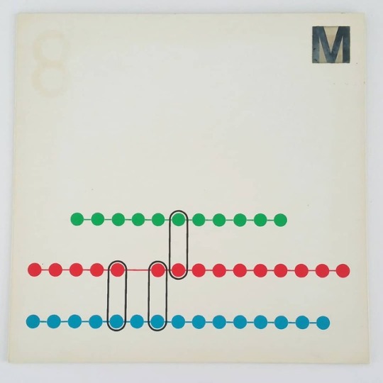
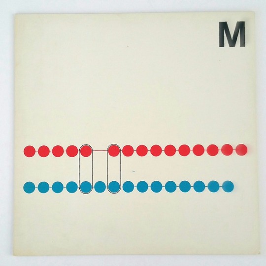
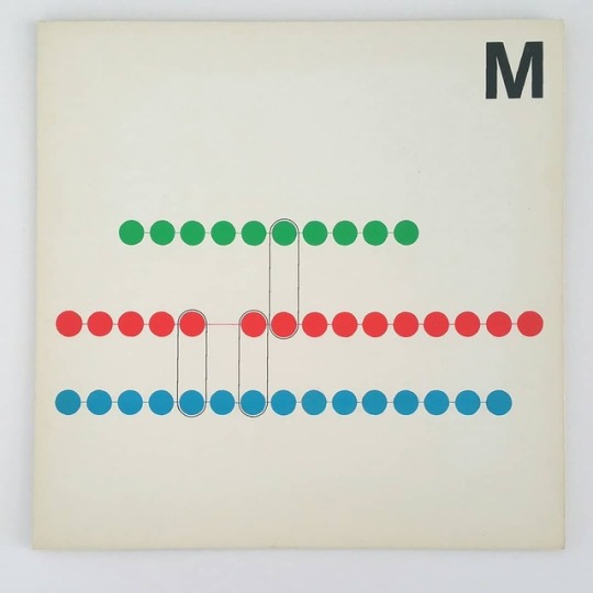
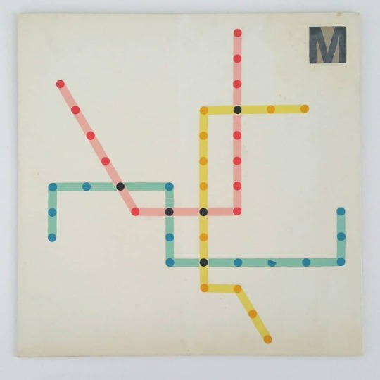
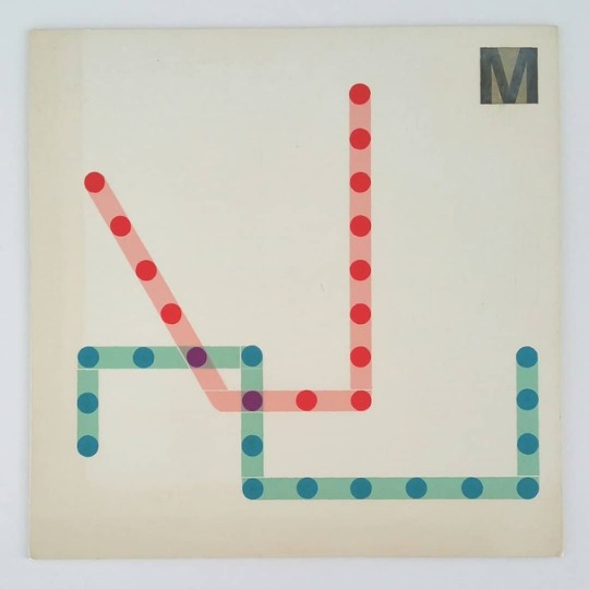
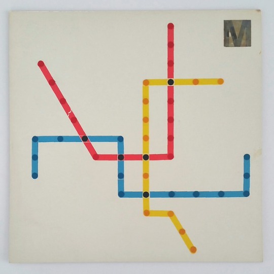
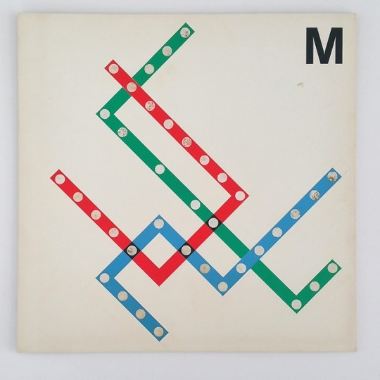
Why Doesn't The M Loop in Queens?
In my efforts to build community support for the QueensLink, I find myself talking to people about extending the M train. Since the M loops back into Queens, some folks thought that we were planning on extending it from its Middle Village end, not from Queens Blvd. Once people realize this, the inevitable next question I get is, “Why doesn’t the M train loop up to Roosevelt Ave to make a…
#Arnold Rothstein#IBX#Interborough Express#Juniper Valley#m train#Maspeth#Middle Village#mta#New York#nyc#queens#Ridgewood#subway#transit#unbuilt
4 notes
·
View notes
Text
Philly Needs a New Metro Map
Last year I was fortunate enough to work on a wayfinding pilot for WMATA, the Washington DC Metro. They were looking at ways to make their signs and maps more user-friendly. Philadelphia just so happened to be doing the same thing, so we used SEPTA as a reference. While putting together resources for my forthcoming Philadelphia Track Map (“it will be done when it’s done”), I spent more time…
6 notes
·
View notes
Text
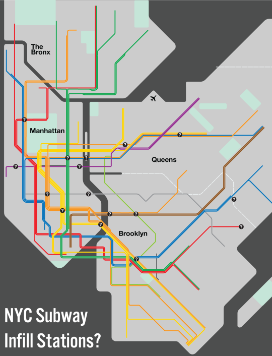
To fill or Not to fill: Infill Stations in NYC
Recently, the Mayor of Atlanta announced that the city would be investing in four new MARTA infill stations. MARTA (Metropolitan Atlanta Rapid Transit Authority) is one of the typical hybrid metro systems that were built after World War II. MARTA, like WMATA in Washington DC, and BART in the San Francisco Bay Area were designed as a response to urban freeways that had devastated older cities and…
View On WordPress
4 notes
·
View notes
Text
Complete and Geographically Accurate Track Map of Washington DC

View On WordPress
6 notes
·
View notes
Text
The Devolution of the IND Second System
View On WordPress
6 notes
·
View notes
Text
Eastern Division Plans
View On WordPress
#brooklyn#Canarsie Line#j train#Jamaica Line#L Train#m train#mta#Myrtle Line#New York#nyc#subway#transit#Transportation
4 notes
·
View notes
Text
Squaring the Circle: Extending the G Train to Queens

View On WordPress
#Deinterlining#Forest Hills#G train#mta#New York#nyc#queens#Queens Blvd Line#subway#transit#Transportation
11 notes
·
View notes
Text
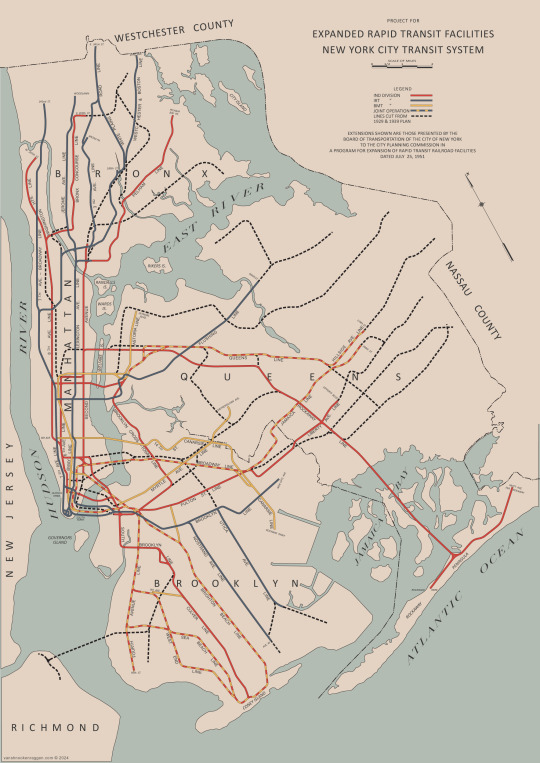
MTA Program for Action 1969 Print
MTA Program for Action 1969 A year ago, I did a deep dive into the MTA’s Program for Action, the ambitious expansion plans they rolled out after their founding in 1968. Since then, I’ve had a number of people reach out to me asking about this particular map. The unfortunate truth is that I don’t really know where this map came from. It’s on the Wikipedia page for the Program for Action, and I…

View On WordPress
2 notes
·
View notes
Text
Exasperated Infrastructures: The Past, Present, and Future of Transportation
Sam Sklar is an urban planner and writer based in NYC. He has some pretty impressive interviews on his substack, Exasperated Infrastructures, which I recommend checking out. I sat down with Sam a couple of times over the last two years, and he’s been nice enough to finally publish them. Give it a read and support Sam’s work. Vanshnookenraggen on the past, present, and future of transportation.

View On WordPress
3 notes
·
View notes
Text
Very Expensive Maps Podcast
Evan Applegate has probably the best podcast on cartography going. I was fortunate enough to site down with Evan and talk about my work. New York City cartographer and chief design officer on using library archives, train-mounted GoPro footage and his own two feet to plot every track in the New York City subway system, a brush with cubicle-based urban planning at the Port Authority,…

View On WordPress
3 notes
·
View notes
Text
Serving Southeast Queens Part 3: Unbuilt Hillside and Van Wyck Lines
I hadn’t intended on revisiting the Southeast Queens Line after my two part series. But in researching Jamaica transit, I found myself down a rabbit hole looking at the IND plans in Jamaica. This post is therefore a prequil to those posts. Subway service first reached Jamaica in 1918. Previously, Jamaica had only been served by the Long Island Railroad (LIRR) and, later, streetcars. There had…

View On WordPress
#Hillside Ave Line#ind#map#mta#New York#nyc#queens#robert moses#subway#transit#Transportation#unbuilt#Van Wyck Expressway#Van Wyck Line
5 notes
·
View notes
Text
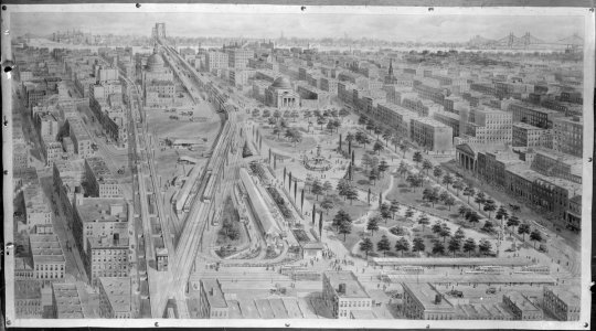
The Last Train to Jamaica: How NYC Almost Replaced Its Els
Image of Queensboro Plaza, twice as large as it is today, before unification. Undated. Image of Queensboro Plaza, twice as large as it is today, before unification. Undated. Image of Queensboro Plaza, twice as large as it is today, before unification. Undated. The New York City subway is famously made up of three formerly private railroads; three distinct networks that were planned to be…

View On WordPress
#brooklyn#el train#elevated#Fulton Line#history#ind#IND Second System#Jamaica Line#Lexington Line#Liberty Line#map#mta#Myrtle Line#New York#new york city#nyc#subway#transit#Transportation#urban
9 notes
·
View notes
Photo

Found in the archives!
Unrealized DC Metro map designs. Although Massimo Vignelli, while at Unimark International, designed the signage for the Washington DC Metro subway in 1968, he didn’t design the map (which was designed by Lance Wyman).
But we recently uncovered a variety of ideas mocked up on these presentation boards. We also found some original sketches for the signage! Stay tuned!
750 notes
·
View notes
Photo

The Illinois | Frank Lloyd Wright | Architecture Hub
98 notes
·
View notes
Text
Tech Transit Podcast
Readers of my blog might remember the Tech Transit Assn. as the group of Brooklyn Tech students who I co-wrote the post on Regional Rail and Extending the 7 Train. They were nice enough to ask me on their podcast to discuss transit issues and the QueensLink. It’s definitely a long one, so enjoy!
youtube
View On WordPress
7 notes
·
View notes
Text
The Lost 1943 IND Second System Plan
1939 IND Second System Map Students of NYC subway history know this map. It is one of the two official maps for the IND Second System plans from 1939. The original, 1929 plan, was published in the New York Times, but this second map’s origin were more unclear. The map in question comes from a technical report, “Report on Power Supply of the New York City Transit System” by the J. G. White…

View On WordPress
22 notes
·
View notes
Text
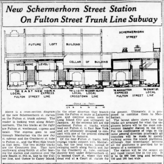
End of the Line: The Unfinished Fulton St Subway
When Duke Ellington wrote “Take the A Train” he wasn’t talking about Brooklyn. Today, the A train runs from Washington Heights at the upper tip of Manhattan, to southern Queens and the Rockaway peninsula. It is, in fact, the longest subway line in the city (especially when it runs local late at night.) But while the A in Manhattan is a venerable workhorse, once it reaches Brooklyn, things…
View On WordPress
8 notes
·
View notes