#3D Geological Visualization
Explore tagged Tumblr posts
Visit Tumblr Blog
Explore Tumblr blogs with no restrictions, modern design and the best experience.
Last Seen Tumblr Blogs


Fun Fact
There were a total of 171.5 billion posts on Tumblr in 2019.
Text
Software for Modeling, Analysis & Visualization | GeomageGeological

Geomage offers advanced software solutions for geological modeling, analysis, and visualization. It provides tools for creating detailed 3D models of subsurface environments, analyzing geological data, and visualizing complex geological structures. Designed for professionals in mineral exploration, geotechnical engineering, and environmental science, Geomage integrates various data sources for accurate, efficient, and insightful geological interpretation.
1 note
·
View note
Text
Rhythms of Nature (2024)
Artist Statement:
I am very passionate about art and biology.
This is why a majority of my artistic practices have included an overarching theme in some capacity: the overlap between art and science, and their interconnectedness within our world.
Rhythms of Nature (2024) expands on the artmaking and conceptual practice of my previous installation Organic Space (2024), which investigated the idea of soundscape ecology.
In the expanded practice for Rhythms of Nature, I wanted to create connections between art, music, and soundscapes of the natural world. Through these connections, I attempted to answer the following questions:
“Where and how do music, art, and the natural world overlap? And can music, fused with art, 'mimic' natural sounds?”
I applied ideas from the soundscape ecologist Bernie Krause, the polymath Wolfgang von Goethe, and the artist Emeka Ogboh to the development process of Rhythms of Nature.
Krause proposed that natural and man-made sounds are not created in the same way. Instead, they each have their unique patterns and frequencies.
Drawing from his experiences in music, he also used musical terminology in his research on natural soundscapes – his practice focusing on the overlap between music and acoustic ecology.
Ogboh’s artistic practice experimented with the ability of sound and art to “transport” people to different places.
For example, his installation Lagos State of Mind III (2017/2020) combined cityscape motifs with hybrid soundscapes made up of field recordings from Berlin and Lagos.
The result was a multisensory experience where you could see and hear “Lagos through Berlin’s eye and vice versa”.
I translated two fundamental aspects of Organic Space into the development of Rhythms of Nature: the soundscapes and the animations.
Both the ‘aquatic’ and ‘terrestrial’ soundscapes are made up of two components:
Multiple biophonic (sounds made by non-human organisms) and geophonic (sounds made by non-biological phenomena such as weather, water and geological processes) sounds, which were field recordings
Two musical tracks per soundscape, with four musical tracks total (created in the program Ableton)
While I retained some tracks from the creation of Organic Space, I created multiple new field recordings and musical tracks, arranging all the audio files into a more multilayered soundscape.
I also created several newer animations alongside one or two of the animations from Organic Space, both being created on the program Procreate.
All the animations were inspired by natural textures, colours, motions, and forms within aquatic and terrestrial environments.
This time, I wanted to experiment with a broader spectrum of textures, colours and frame rate in the animations.
Both components form the projected short film for Rhythms of Nature, a looped narrative sequence shortened from ~4mins to ~2 mins for greater narrative cohesion and impact.
In his book Theory of Colours (1810), Goethe suggested that darkness is just as crucial to the visual experience as light and colour.
He believed that colour resulted from the interplay between darkness and light, therefore, “colour itself is a degree of darkness”.
The third and most challenging aspect was approaching the installation of Rhythms of Nature.
Drawn from Goethe’s theories, darkness and negative space play a significant role in how my projected film interacts with its surroundings.
In one of my initial plans, I explored projection-mapping onto white ceramic sculptures, translating animated forms into a 3D space.
Due to my limited skills in ceramics and wanting to focus on creating a more cohesive installation, I took fabric strips, cut at multiple different lengths, and layered them in rows to resemble ocean waves and a tree canopy.
This arrangement also allows the short film to exist in three spaces:
The first space is formed by the surfaces of the fabric and the wall, where the film exists as ‘light’.
The second space is formed by shadows cast by the fabric, where the film exists as ‘darkness’.
The third space is formed by the translucency of the short film within the shadows, where it exists as ‘colour’.
I would expect members of the audience to experience the installation in ways that are unique to them: some will experience the immersive soundscapes more than the visual aspects, some will be drawn to the visual aspects, and some will experience both equally.
Link to all of the research and process documentation for this project (search under the following tag: #year 3 art studio project 2): www.tumblr.com/aangussca
Installation documentation (full video):
(Please ignore the small periodic clicks as they were not part of the soundscape.)
Soundscape and short film (on its own):
Installation documentation (photos):


Research references
Crary, Johnathan. “Subjective Vision and the Separation of the Senses.” In Techniques of the observer: on vision and modernity in the 19th century, 67–96. Massachusetts: MIT Press, 1990.
Dinneen, James. “Sounds of the forest.” New Scientist, May 18, 2024.
Krause, Bernie., and Roger Payne. “The Language of Soundscapes: New Words for Old Sounds.” In Wild Soundscapes : Discovering the Voice of the Natural World, 55-68. Connecticut: Yale University Press, 2016.
Ogboh. "Ten Minutes with Emeka Ogboh: On Active Listening." In MoMA (Museum of Modern Art), July 14, 2023. Podcast, website, 9:37. https://www.moma.org/magazine/articles/923.
#sca projects#year 3 art studio project 2#sca usyd new contemporaries grad show#animation#sound mixing
4 notes
·
View notes
Text
From Liquid to Luminous: Captivating Artistry with Epoxy Resin

In recent years, the world of art has witnessed a mesmerizing transformation with the advent of epoxy resin. What was once limited to industrial applications, such as epoxy flooring, has now evolved into an extraordinary artistic medium. Epoxy resin art has gained immense popularity due to its versatility, vibrant colors, and captivating luminosity. Artists and enthusiasts alike are embracing this unique medium to create stunning masterpieces that defy traditional artistic boundaries. In this blog, we will explore the fascinating world of epoxy resin art, its remarkable properties, and the boundless possibilities it offers to unleash one's creativity.
The Magic of Epoxy Resin:
Epoxy resin is a two-part liquid material composed of epoxy resin and a hardener. When combined, they undergo a chemical reaction that transforms the mixture into a solid, durable, and glossy material. One of the most remarkable properties of epoxy resin is its ability to capture and reflect light, creating a luminous and ethereal effect. This characteristic, along with its self-leveling nature, makes it an ideal medium for creating captivating art.
Epoxy resin art offers an extensive palette of vibrant colors and textures. Artists can blend pigments and dyes into the resin to achieve stunning, translucent hues. The resin can also be manipulated using various techniques like pouring, layering, and swirling, enabling artists to create intricate patterns and abstract designs. The possibilities are truly limitless.
Creating Masterpieces:
Epoxy resin art has captivated artists worldwide, enabling them to unleash their creativity in exciting and unique ways. Let's delve into some popular techniques and styles within this medium.
Fluid Art: This technique involves pouring and manipulating the resin on a canvas or wooden panel, allowing it to flow and create mesmerizing abstract patterns. Artists can use various additives like alcohol inks, acrylic paints, or metallic powders to enhance fluidity and visual impact.
Geode Art: Inspired by the beauty of natural gemstones, geode art involves creating resin formations that resemble the intricate patterns and vibrant colors found in geodes. By using pigments, crystals, and metallic accents, artists can mimic the striking beauty of these geological wonders.
Resin Jewelry: Epoxy resin's versatility extends beyond traditional canvas art. Artists can craft exquisite jewelry pieces by pouring resin into molds and embedding various elements like dried flowers, gemstones, or metallic flakes. The result is a wearable work of art that encapsulates both elegance and individuality.
Beyond the Canvas: Epoxy Flooring:
While epoxy resin art has taken the art world by storm, its application extends far beyond galleries and studios. Epoxy flooring has become increasingly popular for its durability, easy maintenance, and aesthetic appeal. From residential spaces to commercial establishments, epoxy flooring offers a seamless, glossy finish that can withstand heavy traffic and resist stains.
Epoxy flooring comes in various styles, including solid colors, metallic finishes, and even 3D illusions. This versatile flooring option allows homeowners and business owners to transform their spaces into visually stunning environments that complement their unique style.
Conclusion:
Epoxy resin art has revolutionized the world of creativity, providing artists with a dynamic medium to express their imagination. From fluid abstracts to intricate jewelry pieces, the possibilities within epoxy resin art are endless. The luminous, glossy finish and vibrant colors of epoxy resin captivate viewers and bring life to any space. Moreover, epoxy flooring has become a practical and stylish choice for those seeking durability and visual appeal in their living or working environments. As epoxy resin continues to evolve and inspire artists worldwide, we can anticipate even more breathtaking and awe-inspiring creations in the future. So, grab some epoxy resin, unleash your artistic spirit, and let the magic unfold on canvas or floor, as you embark on a journey of liquid turned luminous artistry.
2 notes
·
View notes
Text
How 3D Vector Maps Support Sustainable Architecture Planning

Beyond Green Walls: How 3D Vector Maps Support Sustainable Architecture Planning
While traditional blueprints offer structural details, they often fall short in illustrating the dynamic interplay between a proposed building and its environmental context. This is where 3D Vector Maps emerge as an invaluable asset, fundamentally transforming how sustainable architecture is planned and presented.
Far more than just visual aids, 3D Vector Maps provide a robust platform for data integration and sophisticated analysis, allowing architects to embed sustainable thinking at every stage of a project. They enable a holistic understanding of how a building will perform environmentally within its specific site, offering insights that are impossible to glean from flat, two-dimensional drawings.
The Challenge of Sustainable Design Visualization
Designing for sustainability is inherently complex, involving numerous factors that are often invisible or difficult to quantify without advanced tools:
Environmental Forces:
Understanding sun paths, wind patterns, and precipitation runoff requires dynamic, spatial visualization.
Resource Management:
Tracking water usage, energy consumption, and material flows within a building and its site.
Site-Specific Nuances:
Every site has unique microclimates, existing vegetation, and geological features that influence sustainable design choices.
Stakeholder Engagement:
Communicating abstract sustainable benefits (e.g., passive solar gain, urban heat island mitigation) to non-technical audiences.
Performance Prediction:
Accurately forecasting a building's energy efficiency or daylighting performance.
3D Vector Maps for Sustainable Architecture Planning
3D Vector Maps are built from mathematical paths rather than pixels, allowing for infinite scalability without loss of detail. When combined with elevation data, they create a precise digital replica of a site and its surroundings. Here's how they specifically support sustainable architecture:
Precise Site Analysis and Environmental Assessment:
The first step in any sustainable project is a thorough understanding of the site. 3D Vector Maps generated from LiDAR, drone surveys, or existing GIS data provide incredibly accurate topographical information. Architects can analyze slopes, identify existing vegetation patterns, understand natural drainage pathways, and pinpoint solar exposures with unprecedented precision. This granular detail is crucial for:
Optimizing Building Orientation:
Positioning a building to maximize daylighting and passive solar heating in winter, while minimizing unwanted solar gain in summer.
Preserving Natural Features:
This precise environmental assessment, visualized through a comprehensive 3D Map Illustration, forms the bedrock of truly integrated sustainable design.
Solar Studies and Daylighting Optimization:
Daylighting is a cornerstone of sustainable design, reducing reliance on artificial lighting and enhancing occupant well-being. 3D Vector Maps enable highly accurate solar studies, allowing architects to:
Simulate Sun Paths:
Visualize how sunlight will hit the building's facade and penetrate interior spaces at different times of day and seasons.
Design Shading Strategies:
Test the effectiveness of overhangs, louvers, or external shading devices in mitigating glare and heat gain.
Assess Impact on Surrounding Structures:
Understand how a new building's shadows might affect adjacent properties or public spaces. This dynamic visualization allows for data-driven decisions that directly impact a building's energy performance and occupant comfort, turning complex calculations into clear visual insights through the Architecture Illustration.
Water Management and Green Infrastructure Integration:
Sustainable architecture places a strong emphasis on responsible water management. 3D Vector Maps are invaluable for:
Rainwater Harvesting:
Identifying optimal locations for rainwater collection systems and visualizing their integration into the landscape.
Permeable Paving and Bioswales:
Simulating stormwater runoff and designing effective permeable surfaces and bioswales to manage water on-site, reducing strain on municipal systems.
Green Roofs and Walls:
The map provides a clear overview of how green infrastructure elements are strategically placed and how they interact with the overall site hydrology, making the complex aspects of water management visibly understandable within the 3D Map Illustration.
Wind Flow Analysis and Microclimate Design:
While requiring more advanced simulation capabilities, the geometric accuracy of 3D Vector Maps can serve as the foundation for computational fluid dynamics (CFD) analysis. This allows architects to:
Analyze Wind Patterns:
Understand how prevailing winds interact with the proposed building and its surroundings.
Optimize Natural Ventilation:
Design building forms and openings to maximize cross-ventilation, reducing the need for mechanical cooling.
Create Comfortable Outdoor Spaces:
Identify and mitigate areas of uncomfortable wind speeds for pedestrian zones and public spaces. This level of environmental analysis, combined with a compelling Architecture Illustration, empowers designers to create more comfortable and energy-efficient outdoor and indoor environments.
Elevating Communication and Stakeholder Engagement
Beyond analysis, 3D Vector Maps are powerful communication tools for sustainable architecture:
Compelling Presentations:
They transform dry data into engaging visual stories for clients, investors, and public officials. Showing a project embedded within its true environmental context, complete with solar paths and green infrastructure, is far more persuasive than 2D plans.
Public Buy-in for Green Initiatives:
Sustainable designs often require community support, especially if they involve unconventional materials or innovative systems. A detailed 3D Map Illustration helps demystify these concepts, allowing residents to visualize the long-term environmental and social benefits of the proposed development. This transparency can be crucial for securing permits and avoiding costly delays.
Cross-Disciplinary Collaboration:
Architects can easily share and discuss sustainable design strategies with landscape architects, civil engineers, environmental consultants, and urban planners, all working from a common, geographically accurate 3D model. The detailed Architecture Illustration acts as a central point of reference for all teams.
The Role of Specialized Services and Future Trends
Many architectural visualization firms and mapping companies now offer services specifically tailored to sustainable planning. They utilize advanced software platforms that combine GIS (Geographic Information Systems) data with BIM (Building Information Modeling) and other simulation tools.
Real-time Performance Simulation:
More powerful computing will enable real-time simulation of energy consumption, water flow, and thermal performance directly within the 3D map environment.
Digital Twin Integration:
Buildings, once constructed, will have persistent digital twins based on these maps, allowing for continuous monitoring and optimization of their sustainable performance throughout their lifecycle.
AI-Driven Optimization:
Artificial intelligence could analyze site data within 3D Vector Maps to suggest optimal sustainable design strategies, further accelerating the design process.
Conclusion
Sustainable architecture is a complex dance between design, engineering, and environmental consciousness. The ability to precisely visualize and analyze these interactions is paramount to success. 3D Vector Maps are proving to be an indispensable tool, elevating sustainable architecture planning from abstract concept to tangible reality. By providing a high-fidelity platform for site analysis, solar studies, water management, and microclimate design, and by facilitating clear and compelling communication through a powerful 3D Map Illustration. The future of sustainable urban development is quite literally taking shape in the third dimension.
0 notes
Text
Gold and Metal Detectors in Kuwait
Gold and Metal Detectors in Kuwait

If you’re looking for Gold and Metal Detectors in Kuwait, German Group Company the right place! Whether you’re a hobbyist searching for hidden treasures or a professional gold prospector, choosing the right device can make a huge difference in your results. In this article, we’ll explore the best Metal Detectors in Kuwait, their prices, and where to buy them.
How Do Gold and Metal Detectors Work?
Metal detectors use electromagnetic induction technology to send waves into the ground. When these waves hit a metal object, they send back a signal, which the metal detectors translates into a sound or visual alert. Some devices use low-frequency waves to detect deeper targets, while others use advanced technologies like multi-frequency detection or 3D ground scanning.
Types of Gold and Metal Detectors in Kuwait
Gold Nugget Detectors
Designed specifically to detect natural gold nuggets in soil and rocks.
Operate on high frequencies to find even the smallest gold particles.
Ideal for desert and mountainous areas in Kuwait.
Popular models:
Gold Monster 1000
Gold Stinger X5
General Metal Detectors
Suitable for finding coins, silver, jewelry, and other metals.
Great for hobbyists and those exploring historical sites.
Popular models:
Cobra GX 8000 Plus
Phoenix
3D Imaging Metal Detectors
Use advanced scanning technology to provide a detailed underground image.
Best for professional treasure hunters and archaeologists.
Popular models:
Gold Star 3D Scanner
Mega Scan Pro
Gold Legend
Where to Buy Gold and Metal Detectors in Kuwait
You can find gold and metal detectors in Kuwait through:
Specialty stores that sell geological and ground scanning equipment German Group Company store
Online marketplaces like German Group Company ,specialized in Gold Detectors retailers.
Authorized dealers to ensure you get genuine products with warranties.
Tips for Choosing the Right Detector
Define your goal: Are you searching for raw gold or buried treasures?
Set your budget: Find a balance between price and performance.
Check for English language support for easier navigation.
Consider detection depth and sensitivity levels.
Choose a trusted brand and avoid counterfeit devices.
0 notes
Text
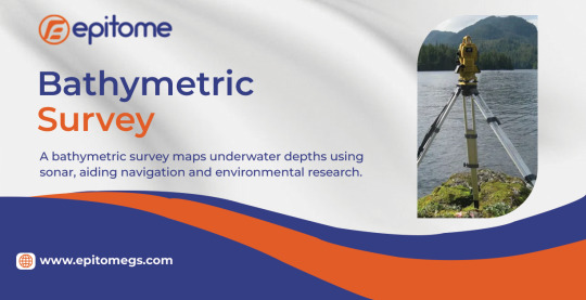
Surveying With Bathymetric: Explore The Benefits | Epitome
Bathymetric surveying is the key to exploring and understanding underwater landscapes. By measuring water depth and mapping the seafloor, this scientific discipline supports safe navigation, marine research, infrastructure development, and environmental protection. As technology evolves, bathymetric surveys have become faster, more precise, and indispensable for industries that rely on accurate underwater data.
Why Bathymetric Surveys Matter
From ensuring maritime safety to preserving marine ecosystems, bathymetric data is crucial for multiple applications:
Safe Shipping & Navigation – Accurate depth charts prevent shipwrecks by identifying shallow zones, submerged rocks, and other hazards.
Offshore Energy Projects – Wind farms, oil platforms, and subsea cables require detailed seabed mapping for stable installation.
Coastal & Flood Management – Governments use bathymetry to predict storm surges, plan flood defenses, and manage sediment buildup.
Scientific Research – Marine biologists and geologists study underwater topography to explore habitats, tectonic activity, and climate change impacts.
Without high-quality bathymetric surveys, underwater operations would be far riskier and less efficient.
Modern Bathymetric Surveying Techniques
Gone are the days of manual lead-line measurements—today’s bathymetric surveys use cutting-edge technology for unmatched precision:
Multibeam Sonar Systems (MBES) MBES emits hundreds of sound beams in a fan-shaped pattern, covering wide swaths of the seafloor. By measuring how long it takes for sound waves to bounce back, these systems generate highly detailed 3D maps.
Side-Scan Sonar (SSS) Unlike MBES, which measures depth, side-scan sonar creates high-resolution images of the seabed, revealing shipwrecks, pipelines, and geological formations.
LiDAR Bathymetry Using laser pulses, airborne LiDAR systems penetrate shallow waters (up to 50m deep) to map coastlines and near-shore zones quickly.
Autonomous Underwater Vehicles (AUVs) Equipped with sonar and cameras, AUVs conduct deep-sea surveys in areas too dangerous or remote for manned vessels.
Satellite-Derived Bathymetry (SDB) Satellites with specialized sensors estimate water depth by analyzing light penetration, providing broad-scale maps where traditional surveys are impractical.
Challenges in Bathymetric Surveying
Despite technological advancements, bathymetric surveys still face obstacles:
Deep Ocean Complexity – The extreme pressure and darkness of deep-sea environments make data collection difficult.
Water Clarity Issues – Murky or turbulent waters can distort sonar and LiDAR readings.
Cost & Accessibility – High-resolution surveys require expensive equipment and skilled operators.
However, innovations like AI-powered data processing and improved sensor technology are overcoming these challenges.
The Future of Bathymetric Mapping
With over 80% of the world’s oceans still unmapped, bathymetric surveying remains a frontier of exploration. Emerging trends include:
AI & Machine Learning – Faster data interpretation and automated anomaly detection.
Real-Time 3D Mapping – Instant seabed visualization for dynamic decision-making.
Global Collaboration – Initiatives like the Seabed 2030 Project aim to map the entire ocean floor by 2030.
Conclusion
Bathymetric surveying is more than just measuring depth—it’s about unlocking the mysteries of underwater worlds. As technology advances, our ability to explore, navigate, and protect marine environments will only improve. Whether for shipping, science, or sustainable development, bathymetry remains an essential tool for understanding our planet’s last great unexplored frontier.
0 notes
Text
Electron Microscopy Market Will See Strong Expansion Through 2031
Allied Market Research, titled, “Electron Microscopy Market Size By Type (Scanning Electron Microscope (SEM), Transmission Electron Microscope (TEM)), By Application (Life Sciences, Material Sciences, Other), By End User (Healthcare, Research Institute, Others): Global Opportunity Analysis And Industry Forecast, 2022-2031". The electron microscopy market was valued at $3.7 billion in 2021, and is estimated to reach $8.3 billion by 2031, growing at a CAGR of 8.5% from 2022 to 2031.
Electron microscopy represents an advanced imaging method that employs a concentrated beam of electrons to visualize specimens with exceptional precision on a micro- to nanoscale level. In contrast to traditional optical microscopy, this technique harnesses the short electron wavelength, enabling the acquisition of high-resolution images that can discern structures at atomic scales. The technology is categorized into two primary forms: Transmission Electron Microscopy (TEM), which directs electrons through a thin sample to generate internal images, and Scanning Electron Microscopy (SEM), which sweeps electrons over a surface to construct 3D images that reveal intricate surface details.
Electron microscopy assumes a pivotal role across diverse scientific domains. In the realm of biology, it proves invaluable for investigating complex cellular structures, subcellular organelles, and viral constituents, thereby propelling advancements in fields like cell biology, microbiology, and medical research. Within materials science, electron microscopy simplifies the scrutiny of material attributes, defects, and crystal formations, pivotal for the design of innovative materials with specific properties. The realm of nanotechnology exploits electron microscopy to characterize nanomaterials, thereby guiding the advancement of nanoelectronics, nanomedicine, and other avant-garde applications. Moreover, industries such as electronics, semiconductor production, and materials engineering employ electron microscopy to ensure quality assurance and refine manufacturing processes.
Electron microscopy finds extensive utility across a broad spectrum of scientific, industrial, and research domains. Academic institutions and research establishments constitute a significant user base, employing electron microscopy to deeply explore fundamental scientific inquiries spanning biology, materials science, and physics. In biotechnology and pharmaceutical sectors, it aids in visualizing cellular structures and biomolecules, thereby propelling drug development and medical research. Industries encompassing electronics, materials engineering, and semiconductor manufacturing depend on electron microscopy for quality assurance, product assessment, and process enhancement.

Nanotechnology enterprises utilize electron microscopy to investigate and manipulate nanomaterials, thereby forming the basis for innovations in fields like nanoelectronics and nanomedicine. Government laboratories utilize it for tasks like forensic analysis, environmental monitoring, and advanced materials investigation. Geological and environmental research institutions leverage electron microscopy to scrutinize mineral compositions, geological formations, and environmental specimens. Collectively, these diverse end users underscore electron microscopy's indispensable role in advancing understanding, catalyzing technological progress, and enriching various scientific and industrial ventures.
The significant factors impacting the electron microscopy market gowth include increase in demand for electron microscope in semiconductor & microelectronics sector and surge in adoption of electron microscopy in the fields of healthcare and life science. In addition, the market is affected by high prices associated with microscopes. Moreover increased R&D activities in the automotive influences the market growth. However, each of these factors is anticipated to have a definite impact on the growth of the global electron microscopy market during the forecast period.The electron microscopy market outlook exhibits high growth potential in commercial and industrial sectors. Furthermore, the Electron Microscopy Market Opportunity is also present in food, forensics, chemical, healthcare, and various other industriesies. According to the current electron microscopy market trends, the most widely used technologies are immune electron microscopy and Transmission Electron Microscopy. The demand for these technologies is expected to grow the electron microscopy industry steadily in the forecasted period.
By type, the market is fragmented into scanning electron microscope and transmission electron microscope. The scanning electron microscope segment was the highest revenue contributor to the market and is estimated to dominate the market due to surge in demand for nanotechnology-based research.
On the basis of application, the market is segregated into life sciences, material sciences, and others. The other segment dominated the market in 2021, contribution significantly in the electron microscopy market growth.
Depending on end user, the market is categorized into healthcare, research institute, and others. The research institute segment exhibited the significant growth and is estimated to expand at a healthy CAGR.
Region wise, the market is analyzed across North America, Europe, Asia-Pacific, and LAMEA.
Key Benefits For Stakeholders
This study comprises an analytical depiction of the electron microscopy market size along with the current trends and future estimations to depict the imminent investment pockets.
The overall electron microscopy market analysis is determined to understand the profitable trends to gain a stronger foothold.
The report presents information related to key drivers, restraints, and opportunities with a detailed impact analysis.
The current electron microscopy market forecast is quantitatively analyzed from 2021 to 2031 to benchmark the financial competency.
Porter’s five forces analysis illustrates the potency of the buyers and suppliers in the industry.
The report includes the electron microscopy market share of key vendors and electron microscopy industry trends.
0 notes
Text
I. Three Major Modes of JPMG: Adapting to All – Terrain Exploration
The JPMG Portable Magnetic Gradiometer has three key modes to meet various terrain and exploration needs.
Mobile Mode
In mobile mode, the JPMG enables on – the – move measurements. Operators can collect magnetic data while walking in the field. Perfect for large – area preliminary surveys, it quickly captures geomagnetic variations. With a high – precision OCXO and multi – satellite systems (GNSS, GPS, BeiDou, GLONASS), it ensures accuracy and stability. Its lightweight and portable design enhances field efficiency.
Walking Mag Mode
Walking Mag mode allows continuous measurements at fixed intervals, generating observation profiles. This is vital for precise exploration and anomaly tracking. Combined with real – time magnetic curve display, operators can instantly monitor field changes, adjust paths promptly, and efficiently Investigate unusual areas.
Base Station Mode
For long – term monitoring and diurnal correction, the Base Station mode is ideal. The device provides a reference for mobile measurements. Working with mobile stations, it effectively eliminates diurnal interference, ensuring accurate data. This mode enables JPMG to perform excellently in complex electromagnetic environments, providing a solid foundation for high – precision magnetic surveys.
II. Real – time Magnetic Curves + 3D Profiles: Making Data Intuitive
The JPMG Portable Magnetic Gradiometer excels in data visualization. It features a host screen displaying real – time magnetic curves for immediate results. When anomalies are detected, operators can swiftly respond, increase measurement density, or conduct further surveys.
Moreover, the JPMG supports 3D profile generation. By processing and analyzing measurement data, users can create 3D magnetic field distribution maps. These maps visually display subsurface geological structures and orebody shapes, aiding geologists in understanding orebody spatial distribution. In practice, 3D profiles are crucial for guiding drilling and mining operations, bringing significant economic benefits to exploration projects.
III. From Power – Up to Mapping: A 10 – Step Quick Guide to the JPMG Proton Magnetometer
Here’s a 10 – step quick guide to help users get started with the JPMG Proton Magnetometer:
Step 1: Preparation
Before measurement, carefully read the instruction manual. Prepare all necessary equipment, including the probe, rods, host, GPS, battery, and charger. Check for any damage to ensure proper operation.
Step 2: Installing the Probe and Rods
Mount the probe on the aluminum rod’s top, avoiding impacts to prevent oil leakage. Securely connect the rods and insert the probe cable into the host’s SENSOR port.
Step 3: Connecting GPS and Accessories
Connect the GPS cable to the host’s GPS port. Attach other accessories like a shoulder strap for easy field operation.
Step 4: Battery Installation and Charging
Insert the rechargeable lithium battery into the host’s battery compartment. Use the standard charger to ensure sufficient power. It’s advisable to fully charge the battery before first use.
Step 5: Power – Up and System Settings
Long – press the ON/OFF button for 3 seconds to power on. Within 5 seconds, press the BIOS key to enter the system settings. Adjust parameters like Y – peak, Y – base point, and clock. Set appropriate screen brightness and contrast.
Step 6: Magnetometer Calibration
Calibrate the JPMG Proton Magnetometer in a magnetically stable area. Keep the device away from ferromagnetic objects during calibration. Record the results for future use.
Step 7: Measurement Parameter Settings
In the host’s measurement interface, set parameters based on exploration needs. These include working mode, file name, and system position. Also, configure measurement mode, speed, and cycle time to meet measurement requirements.
Step 8: Starting the Measurement
After preparations, begin measuring by pressing the corresponding button. Maintain device stability and monitor real – time magnetic curves to ensure smooth measurement.
Step 9: Data Viewing and Exporting
Post – measurement, view data in the data viewing interface. Ensure data integrity and accuracy. Export data via USB or a 10 – pin waterproof RS – 232 serial port for further analysis.
Step 10: Power – Off and Equipment Maintenance
After measurement, long – press the ON/OFF button for 3 seconds to power off. Store the equipment properly. Clean and maintain the probe and rods to ensure long – term reliability.
In summary, the JPMG Portable Magnetic Gradiometer offers excellent performance, intelligent operation, and strong data visualization. It’s a great choice for resource exploration, providing efficient and precise solutions for various projects. Choose JPMG to embark on your smart exploration journey!
0 notes
Text

Advanced visual localization and topographic mapping enhance Zhurong rover's Mars exploration
A collaborative research team has improved visual localization and topographic mapping techniques that enable China's Zhurong rover to navigate and conduct scientific investigations on Mars. These techniques played a crucial role in the success of the Tianwen-1 mission, which is China's first independent interplanetary exploration effort.
This study was published in the IEEE Journal of Selected Topics in Applied Earth Observations and Remote Sensing. The researchers are affiliated with the Aerospace Information Research Institute of the Chinese Academy of Sciences and the Beijing Aerospace Control Center.
China's Tianwen-1 mission, launched in July 2020, aimed to map the Martian surface, analyze geological structures, and study the planet's climate and environment. A key component of this mission was the Zhurong rover, which landed in southern Utopia Planitia on May 22, 2021. The rover's ability to traverse the Martian terrain and conduct in-situ scientific investigations depended heavily on accurate localization and high-resolution topographic mapping.
In this study, the researchers developed several innovations to enhance Zhurong's navigation system, including vignette correction and online camera mast calibration techniques, which improved the quality of images captured by the rover's Navigation and Terrain Cameras. These enhancements allowed for the creation of high-resolution 3D topographic maps with centimeter-level accuracy, which were critical for obstacle analysis and rover path planning.
Furthermore, by integrating cross-site visual localization and digital orthophoto map matching, the researchers refined the rover's position to within an accuracy of 0.50% relative to the traverse length, significantly better than the 3.11% accuracy of the rover's onboard dead-reckoning system.
The study indicated that the Zhurong rover traveled a total distance of 2,009 meters, which is 88 meters more than the 1,921 meters recorded by the onboard odometer. This discrepancy was caused by wheel slippage due to the downslope trend of the traverse, emphasizing the importance of accurate localization for understanding the rover's movement on Mars.
Additionally, the high-resolution topographic maps facilitated a detailed analysis of geological features, such as Transverse Aeolian Ridges and impact craters, providing valuable insights into Mars' geological history and climatic evolution.
IMAGE: The traverse of Zhurong rover generated from visual localization. Credit: AIR
1 note
·
View note
Text
Optimizing Mining Operations with K-MINE: How Smart Geological Modelling Boosts Productivity

In the dynamic world of mining, optimizing operations through accurate geological modelling and efficient mine planning is crucial for productivity and profitability. K-MINE emerges as a robust and innovative solution, delivering advanced 3D geological modelling capabilities, precise resource estimation, and streamlined operational workflows. By leveraging these capabilities, mining companies can achieve greater accuracy, improved decision-making, and enhanced efficiency, driving overall productivity and sustainable growth.
Enhancing Resource Estimation Accuracy with Advanced 3D Modelling
Accurate geological modelling forms the backbone of successful mining operations, enabling precise resource estimation crucial for planning and profitability. K-MINE's sophisticated 3D modelling tools provide detailed visual representations of subsurface geological formations. These precise models significantly reduce the uncertainty inherent in resource estimation, allowing geologists and engineers to confidently determine mineral quantities, quality, and spatial distribution.
By offering highly detailed geological insights, K-MINE empowers mining teams to effectively identify the most promising extraction zones, ensuring resources are optimally utilized and waste is minimized. The improved accuracy in resource estimation translates directly into financial benefits, reducing exploration risks and aligning investment decisions more closely with operational realities.
Optimizing Mine Design and Operational Scheduling
Mine design and scheduling significantly influence operational efficiency and productivity. K-MINE excels by providing intuitive tools that simplify and optimize these complex processes. With K-MINE, mining professionals can rapidly develop and evaluate various mine layouts and scheduling scenarios, identifying the most effective approaches before any physical implementation.
This powerful simulation capability not only boosts operational efficiency but also significantly reduces operational risks and costs. Mines using K-MINE can confidently manage their resources, ensuring that machinery, labor, and capital are deployed most effectively. Such comprehensive optimization directly contributes to increased productivity and enhanced operational performance.
Data Integration for Comprehensive Decision-Making
Modern mining operations rely heavily on diverse geological, geophysical, and operational data sets. Integrating this complex data into a coherent and actionable format is critical for effective decision-making. K-MINE delivers a unified platform that seamlessly integrates multiple data sources into comprehensive geological models and reports.
This integrated approach allows stakeholders to make well-informed decisions based on a holistic view of the mining operation. By facilitating the synthesis of geological, geophysical, and operational data, K-MINE ensures that strategic decisions are not only informed but proactive. This integrated data capability reduces the potential for costly errors and accelerates strategic planning and execution.
Enhancing Collaboration with Cloud-Based Solutions
Efficient collaboration among geographically dispersed teams is a common challenge in the mining industry. K-MINE addresses this through its robust cloud-based solutions, which facilitate seamless and real-time collaboration across teams, regardless of location.
Cloud-based accessibility ensures all stakeholders—from engineers and geologists to operational managers—have immediate access to current data and project updates. Real-time collaboration tools within K-MINE reduce communication barriers, speed up decision-making processes, and ensure team alignment, all of which significantly boost productivity and operational agility.
User-Friendly Tools and Predictive Analytics
Complexity in geological modelling and mine planning processes often leads to inefficiencies. K-MINE addresses this by offering intuitive, user-friendly tools designed for ease of use by both novice and experienced users. The simplified interface and automated workflows help teams accomplish tasks swiftly and accurately, reducing training time and boosting overall productivity.
Additionally, K-MINE incorporates predictive analytics capabilities that identify potential operational risks and suggest effective mitigation strategies. By proactively addressing these risks, mining companies can prevent disruptions, reduce downtime, and maintain consistently high levels of productivity.
Case Study: Real-World Success with K-MINE
A practical demonstration of K-MINE's effectiveness is evident in its application by Dilip Buildcon Ltd. for the Siarmal Coal Block project in Odisha, India. Utilizing K-MINE, the company was able to create precise geological models that enabled effective division of resources into manageable sub-blocks, enhancing resource utilization and operational efficiency. The platform's adaptability also allowed for continuous updates and refinements, underscoring its value in dynamic mining environments.
Elevate Your Mining Operations with Innourbia
At Innourbia, we use smart technologies like K-MINE, dedicated to transforming industries through innovation and efficiency. By integrating K-MINE into your mining operations, you not only enhance resource estimation accuracy and streamline operational processes but also position your business as a leader in sustainable and productive mining practices.
Explore more groundbreaking solutions and discover how Innourbia can propel your operations toward greater profitability, efficiency, and sustainability. Visit Innourbia today to revolutionize your mining operations.
0 notes
Photo

Idoceras Fossil Ammonite - Lower Kimmeridgian, Jurassic - San Luis Potosí State, Mexico - Genuine Specimen + COA
For sale is an authentic Idoceras ammonite fossil from the Lower Kimmeridgian stage of the Jurassic Period, discovered in San Luis Potosí State, Mexico. This fossil is a carefully selected specimen, displaying the distinct ribbed shell and coiled morphology of the Idoceras genus, making it a scientifically significant and visually stunning addition to any fossil collection.
Geology & Fossil Type:
This ammonite originates from the Lower Kimmeridgian, a stage within the Late Jurassic, dating back approximately 152-157 million years. The Kimmeridgian seas covered much of what is now North and Central America, providing an abundant habitat for ammonites. These fossils are particularly valuable for biostratigraphic dating, allowing geologists to correlate Jurassic rock formations worldwide.
Idoceras belonged to the subclass Ammonoidea, an extinct group of marine mollusks closely related to modern squids and octopuses. Ammonites were active swimmers, using their chambered shells for buoyancy control to move efficiently through prehistoric seas. Their ribbed shells provided protection against predators and reinforced their structural integrity.
Fossil Details:
100% Genuine Fossil – No Replicas or Synthetics
Comes with a Certificate of Authenticity
From the Alice Purnell Collection, a highly regarded fossil collection
Scale cube = 1cm for size reference (please see photos for full dimensions)
You will receive the exact specimen shown in the listing
This rare Idoceras ammonite fossil is an ideal specimen for fossil collectors, educators, and natural history enthusiasts. Whether displayed as a stunning showcase piece, studied for its geological significance, or given as a unique prehistoric gift, this ammonite offers an extraordinary glimpse into the ancient marine world of the Jurassic seas.
Shop with confidence! We specialize in authentic fossils and minerals, ensuring each specimen is carefully selected and properly identified. If you have any questions, feel free to reach out!
Fast & Secure Shipping Available Worldwide.
#Idoceras Ammonite#Jurassic Fossil#Lower Kimmeridgian Ammonite#Fossil Ammonite#San Luis Potosí Fossil#Mexican Fossil#Authentic Fossil#Prehistoric Marine Fossil#Nautiloid Fossil#Fossil Collector#Certified Fossil#Rare Ammonite#Geological Specimen#Ammonite from Mexico#Fossil Gift
0 notes
Text

Explore advanced geological modeling software and solutions at GeoMage. Discover tools for subsurface analysis, 3D visualization, and resource estimation, tailored for your geological and environmental projects.
0 notes
Text
3D Paintings and Wall Art will give your space a powerfully updated appearance.
Interior design features 3D paintings and 3D wall painting as a contemporary popular choice which adds depth with texture and visual attraction to domestic spaces. 3D paintings contribute to dimensional artwork that animates spaces through their three-dimensional style. Modern 3D wall painting together with 3D artwork allows you to modify your interior decor through impressive artistic visuals that create powerful effects.
What Makes 3D Paintings Special?
3D paintings generate depth perception which allows them to dominate typical wall decoration. Through their use of perspective alongside shadowing and layering techniques the art pieces establish an appearance of three-D wall art three-dimensional objects and landscapes and abstract designs that emerge from flat surfaces. Acrylic alongside oil and digital methods serve artists as their tools to make captivating artworks that become attention-grabbers.
People are drawn to walls that use three-dimensional art wall 3D techniques because these artworks bring both natural elements and futuristic abstract designs together to start meaningful conversations.
Residential wall interiors receive an enhancement through 3D painting techniques.

The home application of 3D wall painting enables residents to introduce personality to their rooms through innovative artwork. 3D wall paintings adapt to all interior design styles because they can be simple or elaborate in design. Some popular themes include:
The depiction of trees coupled with mountains and waterfalls on walls forms an environment that relaxes people.
Abstract wall designs made from geometric forms along with optical visual effects create modernistic decorative elements.
Modern urban landscapes consisting of architectural elements as well as cityscapes provide a contemporary aesthetic to spaces.
People who choose the right 3D wall decor art can create personalized rooms that stay consistent with the selected interior theme
3D Paintings and Wall Art will give your space a powerfully updated appearance
Interior design features 3D paintings and 3D wall painting as a contemporary popular choice which adds depth with texture and visual attraction to domestic spaces. Traditional flat painting techniques differ completely from these artistic works which revitalize walls to produce experiential and expressive environments. Modern 3D wall painting together with 3D artwork allows you to modify your interior decor through impressive artistic visuals that create powerful effects.
What Makes 3D Paintings Special?

3D wall painting at home generates depth perception which allows them to dominate typical wall decoration. Through their use of perspective alongside shadowing and layering techniques the art pieces establish an appearance of three-dimensional objects and landscapes and abstract designs which emerge from flat surfaces. Through acrylic, oil, and digital techniques artistic creators create alluring masterpieces that people become fascinated by.
People are drawn to walls that use three-dimensional art techniques because these artworks bring both natural elements and futuristic abstract designs together to start meaningful conversations.
Residential wall interiors receive an enhancement through 3D painting techniques.
The home application of 3D wall painting for living rooms enables residents to introduce personality to their rooms through innovative artwork. 3D wall art decor paintings adapt to all interior design styles because they can be simple or elaborate in design. Some popular themes include:
Brushed walls with nature scenes featuring flora and geologic and liquid elements generate tranquil surroundings.
Abstract wall designs made from geometric forms along with optical visual effects create modernistic decorative elements.
Urban landscapes include cityscapes together with architectural elements which create a modern appearance in interior design.
People who choose the right 3D wall accents have the ability to create personalized rooms that stay consistent with the selected interior theme.
#3d paintings#3d wall painting#3d artwork#3d wall painting for home#modern 3d wall painting#3d wall painting for living room#3d wall accents#3d wall decor#3d wall art decor#three d wall art#art wall 3d
0 notes
Text
How 3D Vector Maps Assist in Managing Large-Scale Infrastructure Projects

The Unseen Backbone: How 3D Vector Maps Assist in Managing Large-Scale Infrastructure Projects
Large-scale infrastructure projects – think new railway lines, sprawling urban developments, extensive utility networks, or critical flood defense systems – are among the most complex undertakings imaginable. They involve colossal budgets, diverse stakeholders, multi-disciplinary teams, and timelines stretching over years, if not decades. Traditionally, managing these behemoths relied on intricate 2D blueprints, complex GIS data, and often, sheer human experience. While effective to a degree, these methods often struggle to convey the holistic picture, leading to communication gaps, potential clashes, and slower decision-making.
In this intricate dance of engineering and planning, 3D Vector Maps have emerged as a revolutionary tool, transforming how infrastructure projects are conceived, managed, and communicated. Far beyond a simple topographical view, these dynamic digital environments provide an unparalleled level of clarity and spatial understanding, making them an indispensable asset for project managers navigating the complexities of modern development.
Know The Visual Power of 3D Vector Maps
What exactly are 3D Vector Maps, and why are they so effective? Unlike raster images (which are pixel-based), vector maps are built from mathematical paths, allowing for infinite scalability without loss of detail. When extruded into the third dimension, these maps bring elevation, existing structures, and proposed designs into a lifelike, interactive environment. This allows for an intuitive understanding of terrain, urban fabric, and how new infrastructure will integrate with the existing world.
The ability to render precise spatial relationships, coupled with the inclusion of environmental data, turns these maps into powerful visualization platforms. A well-executed 3D Map Illustration can highlight not just the proposed road, but also its impact on surrounding buildings, elevation changes, and even potential view obstructions, providing a holistic perspective that 2D plans simply cannot offer.
Enhance Project Planning and Design
The benefits of integrating 3D Vector Maps permeate every phase of a large-scale infrastructure project:
Comprehensive Site Analysis and Environmental Impact:
Before any ground is broken, understanding the project site is paramount. 3D Vector Maps provide an incredibly detailed digital terrain model, allowing engineers and planners to analyze elevation changes, existing geological features, water bodies, and vegetation. This is crucial for precise excavation planning, identifying potential environmental sensitivities, and ensuring compliance with regulations. The ability to overlay environmental data directly onto the 3D terrain provides immediate insights into how a proposed highway extension, for instance, might affect local hydrology or wildlife habitats. This level of comprehensive pre-visualization significantly reduces unforeseen challenges later on.
Optimized Route and Infrastructure Planning:
For linear projects like roads, pipelines, or transmission lines, 3D Vector Maps are invaluable for route optimization. Engineers can virtually test multiple alignments, assessing factors like cut-and-fill volumes, bridge requirements, tunneling feasibility, and proximity to existing utilities or properties. This iterative design process within a 3D environment allows for the most efficient and cost-effective solutions to be identified before significant resources are committed.
Precise Clash Detection and Coordination:
Large infrastructure projects involve multiple layers: underground utilities (water, gas, fiber optics), foundations, structural elements, and above-ground components. 3D Vector Maps can integrate data from various engineering disciplines (BIM models, CAD drawings) to visually identify potential conflicts or overlaps between different elements. This pre-emptive identification of clashes – for example, a new foundation interfering with an existing sewer line – saves immense time, cost, and rework during the construction phase. The visual clarity offered by an Architecture Illustration that highlights these potential conflicts is indispensable.
Bridging Communication Gaps and Fostering Stakeholder Engagement
One of the most significant challenges in large infrastructure projects is communicating complex plans to a diverse audience, many of whom lack technical backgrounds. 3D Vector Maps excel in this area:
Clearer Presentations for Non-Technical Audiences:
Explaining the intricate details of a new metro line or a large-scale bridge to investors, public officials, or community members can be daunting with only spreadsheets and technical drawings. 3D Vector Maps transform these abstract plans into compelling visual narratives. Stakeholders can literally "fly through" the proposed project, see it integrated into their city, and understand its impact from various perspectives. This clarity fosters trust and makes it easier to secure approvals and funding.
Effective Public Consultation and Engagement:
Community acceptance is vital for major infrastructure projects. Residents can see how a proposed road widening might affect their neighborhood, visualize changes to park spaces, or understand noise mitigation measures. This transparency, often presented as a clear 3D Map Illustration, allows for more informed feedback from the public, leading to designs that better serve community needs and reduce opposition.
Streamlining Construction, Operations, and Future Asset Management
The utility of 3D Vector Maps extends far beyond the planning and design phases:
Optimized Construction Logistics:
During construction, the maps can be used for logistical planning, optimizing the placement of heavy machinery, material laydown areas, and temporary access roads. Real-time data from construction progress can be overlaid onto the 3D model, providing project managers with an up-to-the-minute visual of the build, helping to keep projects on schedule and within budget.
Dynamic Asset Management:
Once constructed, large-scale infrastructure assets require continuous management and maintenance. 3D Vector Maps serve as dynamic "digital twins" of these assets. Information about utility lines, bridge inspection data, maintenance schedules, and even sensor readings (e.g., from smart city infrastructure) can be integrated and visualized on the map. This provides a comprehensive, living record of the infrastructure, vastly improving long-term operational efficiency and emergency response capabilities.
Predictive Analysis and Simulation:
With rich data integrated into 3D Vector Maps, projects can move into predictive analysis. Engineers can simulate traffic flow on new road networks, model flood scenarios to test defense systems, or analyze the impact of different urban planning decisions over time. This foresight allows for proactive problem-solving and the creation of more resilient, future-proof infrastructure. The visual impact of such simulations through a detailed 3D Map Illustration is unparalleled.
The Role of Specialized Expertise
Creating and managing these sophisticated 3D Vector Maps requires specialized expertise. Companies offering these services leverage advanced GIS software, 3D modeling tools, and often integrate with Building Information Modeling (BIM) data. The process involves meticulous data collection, precision modeling, and skilled Architecture Illustration to ensure both technical accuracy and visual clarity.
Conclusion
In the era of increasingly complex and ambitious infrastructure projects, the demand for tools that foster clarity, efficiency, and seamless collaboration is paramount. 3D Vector Maps are proving to be that essential tool, transforming how projects are conceived, designed, built, and managed. By providing an unparalleled visual understanding of terrain, proposed structures, and integrated data, they empower project managers to make smarter decisions, bridge communication gaps among global teams, and engage stakeholders more effectively. From initial planning and precise 3D Map Illustration to long-term asset management, these digital models are not just a visualization enhancement – they are the unseen backbone ensuring the successful delivery of the infrastructure that shapes our world.
1 note
·
View note
Text
Albatec: Pioneering Geotechnical Engineering Excellence
youtube
In the ever-evolving field of civil engineering, geotechnical engineering emerges as a cornerstone discipline, ensuring the success and stability of construction projects. Albatec, a leader in this specialized area, is dedicated to providing innovative solutions for complex subsurface challenges. From designing resilient foundations to assessing soil behavior and mitigating risks, Albatec’s expertise empowers projects across diverse sectors to thrive.
Understanding Geotechnical Engineering Geotechnical engineering focuses on the analysis of earth materials like soil, rock, and groundwater to determine their suitability for construction. This discipline underpins the stability of critical infrastructure such as skyscrapers, bridges, dams, and tunnels. By evaluating subsurface conditions, geotechnical engineers address risks like landslides, soil erosion, earthquakes, and groundwater flow, ensuring structures are safe, stable, and efficient.
Albatec: Your Trusted Geotechnical Partner Albatec stands out as a trusted name in geotechnical engineering, blending technical expertise with cutting-edge technology to tackle even the most demanding projects. Let’s explore the services that position Albatec as a leader in the field:
Comprehensive Site Investigations Before construction begins, Albatec’s team conducts detailed site investigations to assess geological conditions. Using advanced techniques like cone penetration testing (CPT), borehole drilling, and soil sampling, they gather critical data to guide design decisions and ensure project viability.
Precision Foundation Design Foundations are the bedrock of any structure. Albatec excels in crafting custom foundation solutions, whether for low-rise residential buildings or towering skyscrapers. Their designs ensure stability by aligning with site-specific conditions and project demands.
Slope Stability Solutions In hilly or mountainous regions, slope stability is paramount. Albatec employs advanced modeling tools to analyze potential risks and recommend reinforcement measures such as retaining walls, ground anchors, or soil nailing, safeguarding both the structure and the surrounding environment.
Earthquake-Resilient Engineering Seismic activity poses unique challenges to construction. Albatec’s expertise in earthquake engineering ensures structures can endure ground motion. Their dynamic analysis integrates seismic considerations into every design, prioritizing resilience and safety.
Ground Improvement Techniques Weak or unstable soil? No problem. Albatec offers advanced ground improvement methods, including soil compaction, grouting, and the use of geosynthetics. These techniques enhance soil properties, paving the way for secure construction.
Geotechnical Risk Assessments Construction projects carry inherent subsurface risks. Albatec’s thorough geotechnical risk assessments identify potential hazards and develop mitigation strategies, ensuring projects progress smoothly and safely.
What Sets Albatec Apart?
Innovative Technology Leveraging tools like ground-penetrating radar, geotechnical software, and 3D modeling, Albatec ensures precise and reliable results. These technologies enable real-time visualization of subsurface conditions, enhancing decision-making and project outcomes.
Customized Solutions Every project is unique, and Albatec tailors its services to meet specific needs. From small-scale residential developments to major infrastructure projects, their client-focused approach guarantees optimal results.
Experienced Professionals Albatec’s team brings unparalleled expertise to the table. With extensive knowledge of soil mechanics, geology, and structural engineering, their engineers deliver world-class solutions for projects of all scales.
Commitment to Sustainability Recognizing the importance of eco-friendly practices, Albatec prioritizes sustainability by minimizing soil disruption and reducing carbon footprints. Their designs align with environmental standards, supporting a greener future.
Real-World Impact of Albatec’s Expertise Albatec’s geotechnical solutions play a critical role in diverse projects:
Infrastructure Development: Stabilizing highways, railways, and bridges to handle heavy loads and environmental pressures.
Commercial Construction: Securing foundations for skyscrapers and industrial facilities in challenging terrains.
Renewable Energy: Supporting wind turbines and solar farms with optimized foundations for varying soil conditions.
Disaster Mitigation: Preventing landslides, floods, and earthquake damage with proactive engineering strategies.
The Future of Geotechnical Engineering As urbanization and climate change redefine construction challenges, the demand for innovative geotechnical solutions continues to rise. Albatec is at the forefront of this evolution, embracing technologies like AI-driven predictive models and smart sensors that monitor ground movement in real time. These advancements position Albatec as a pioneer, ready to tackle emerging challenges with confidence.
Conclusion Geotechnical engineering forms the backbone of safe and sustainable construction. Albatec’s expertise, bolstered by innovation and a commitment to excellence, ensures every project is built on a solid foundation. Whether you’re embarking on a residential development, infrastructure initiative, or renewable energy project, Albatec’s tailored geotechnical solutions are the key to success. Partner with Albatec and lay the groundwork for a future of stability and resilience.

1 note
·
View note