#3d LiDAR
Text
My dad’s phone has a 3D LiDAR Scanner. His cat is wondering why he’s laughing so hard
[video description: 3D render of a cat sleeping on the back of a couch. The cat shape is inaccurate, and the cat’s image is smeared across a flat rounded shape.]
1K notes
·
View notes
Text


Photos.
2 notes
·
View notes
Text
What is "Scan to BIM" and advantages of Scan to BIM?
In short, Scan to BIM is a process where we use 3D laser scanners or laser Drone to digitally capture any building or structure and generate point cloud data that can be used to create 3D models, 2D plans by the help of point cloud supported CAD software such as Revit, AutoCAD, Archicad, inventor, rhino, etc and this process also helps to collect project information which can then be used to renovate, refurbish, develop, and maintain the building or site.
If you are from the field of construction, you must be knowledgeable about this term when it is related to the construction of any building, structure, or anything that can play the most important role in Scan to BIM. We'll know the important aspects of the Scan to BIM, and along with understanding what really BIM is, we will also be able to understand how it functions and how it really becomes beneficial in the field of construction.
Advantages of Scan to Bim
The use of technology has been such that even in the field of construction, it has become imperative, and the use of technology in Scan to Bim has been done in a great way so that its benefits may be understood very easily. Let's know some of the benefits of Scan to BIM which help in understanding any structure or building properly.
The first thing that Scan to BIM does is remove any kind of human error which is certainly possible if, in the process of BIM documentation, the traditional method is followed.
Data collection becomes quite easier and it takes very less time in this and that's where Scan to BIM plays a very important role.
Information sharing becomes easier with the process of Scan to BIM and the data which comes out of the process gets released very quickly.
It also becomes easier for teams to get relaxed as they don't have to visit the site again and again and even if they manage to visit once, it will be sufficient to collect the data thoroughly.
The next process is about the inspection after the collection of the data, and inspection can be done off-site in an easy manner. Once the inspection is done, it will not be difficult to devise the perfect plan to take the project ahead.
The process of Scan to BIM gives the assurance of quality and if a particular team goes through a new project or construction, they can use this process to give the project great quality.
Let's understand the procedures of Scan to BIM
The contractors who are from the field of Architecture, Engineering, and Construction (AEC) have to collect the data which is in great accuracy and speed and this happens because the technology of 3D scanning is definitely great. After the collection of the data, it gets placed on a particular tripod with an eye-safe laser which rotates at high speed. Once the laser beam points to a solid surface, the position related to scanning gets recorded in the form of the XYZ axis. These axis points are also known as points and a great number of points are capable enough to create a digital picture which can be called point clouds. After this process, it will be easy to get color images which may definitely give a realistic 3D representation by colorizing the scan. And this becomes important for anybody to know before visiting a particular site in the Scan to BIM process.
Conclusion
The BIM process is such that it is able to include Scan to BIM and considers it as a main component when it comes to construction and building maintenance. If you talk about the growth of the BIM process, it certainly indicates that there is going to be an increase in the accessibility and usability of cloud technology. There is an environment for all stakeholders such as project managers, building teams, designers as well as surveyors who are able to get the benefits at all levels of the project. They also need to make sure that the collaboration takes place at a great level and with full confidence so that the project related to Scan may be accomplished one time. Once the project gets completed on time, it will be a matter of gaining the client's satisfaction.
If you're looking for services related to Scan to BIM, you can definitely contact our platform Rvtcad.com and if you want to get the details, you can feel free to message us anytime.
xxxxxxxxxxxxxxxxxxxxx
2 notes
·
View notes
Text
TEDにて
ベン・カシーラ:3Dスキャナーでとらえる古代遺跡
(詳しくご覧になりたい場合は上記リンクからどうぞ)
世界中にある古代遺跡は、過去の文明について驚くべき手がかりを与えてくれますが、公害、戦争、放置などのために失われる危険にさらされています。
そこで、画期的な3次元リアルタイムスキャンシステムの発明者であるベン・カシーラは、自らの発明品を使って世界遺産を詳細に高速でリアルタイムスキャンし保存する活動をしています。
このスキャンした映像を見られるiPhoneアプリケーション(Mount Rushmore Virtual Tour)もあります。(最後のデモをお見逃しなく)
世界初の3Dレーザースキャンシステムを作られた仕組みとは、長距離レーザースキャンで、レーザービームのパルスを送出してビームの飛行時間を計測、光が表面に反射して戻ってくるまでの時間を記録します。
スキャナは2つの鏡を使ってビームの水平角と鉛直角を測り、正確な「x、y、z」座標を求め点の位置を3次元可視化プログラムに記録。
このすべてが数秒以内に瞬時に行われます。一度に何百万という点の位置を非常に高い精度と解像度で収集できます。
従来の測量器具を使うと大急ぎでやっても取れるのは、1日にせいぜい500地点といったところです。それがこの装置だと1秒間に1万地点です。人間の限界を遥かに超えています。
この装置が測量はもちろん建築や3Dキャプチャを行う業界においてパラダイムシフトでした。
幸い開発当初よりもこの20〜30年におけるデジタル技術の発展は、私たちのデジタル保存の戦いに使える力強い武器の開発を可能にしました。
たとえば、3次元レーザースキャンシステム。
ますます強力になっていくコンピュータ3Dグラフィックス。
高解像度デジタル写真、それに、インターネット。
加速しつつある破壊を目の当たりにし、500カ所の世界遺産を5年以内にデジタル保存しようという試みです。
遺跡の維持費は莫大なこともあるため、いざという時に安心ですね。もっと拡大すると良いかもしれません。
オープンデータは、特定のデータが、一切の著作権、特許などの制御メカニズムの制限なしで、全ての人が
望むように再利用・再配布できるような形で、商用・非商用問わず、二次利用の形で入手できるべきであるというもの。
主な種類では、地図、遺伝子、さまざまな化合物、数学の数式や自然科学の数式、医療のデータやバイオテクノロジー
サイエンスや生物などのテキスト以外の素材が考えられます。
2018年現在では、サピエンスは20万年前からアフリカで進化し、紀元前3万年に集団が形成され、氷河のまだ残るヨーロッパへ進出。紀元前2万年くらいにネアンデルタール人との生存競争に勝ち残ります。
そして、約1万2千年前のギョベクリ・テペの神殿遺跡(トルコ)から古代シュメール人の可能性もあり得るかもしれないので、今後の「T型オベリスク」など発掘作業の進展具合で判明するかもしれません。
メソポタミアのシュメール文明よりも古いことは、年代測定で確認されています。古代エジプトは、約5千年前の紀元前3000年に人類最初の王朝が誕生しています。
こういう新産業でイノベーションが起きるとゲーム理論でいうところのプラスサムになるから既存の産業との
戦争に発展しないため共存関係を構築できるメリットがあります。デフレスパイラルも予防できる?人間の限界を超えてることが前提だけど
しかし、独占禁止法を軽視してるわけではありませんので、既存産業の戦争を避けるため新産業だけの限定で限界を超えてください!
2021年時点では・・・
自動運転車がクルマの周囲になにがあるかを認識するためにもLiDARが活用されている。
「LiDAR」は、「Light Detection and Ranging」(光検出と測距)の略。
レーザー光を利用して離れた物体の距離を測る仕組み。
電波を使って離れた物体との距離を測るレーダーもあるが、これのレーザー光版で、iPhoneなどのスマートフォンにも搭載されたこと。
LiDARスキャナは、光の反射をソナーのように使い広い範囲の距離(奥行き)を測る装置。自動運転やロボットのナビゲーションなどでも広く使われる歴史ある技術。
それから、技術革新による小型化。大量生産からコストが安くなり普及しつつあります。
最後に、マクロ経済学の大目標には、「長期的に生活水準を高め、今日のこども達がおじいさん達よりも良い暮らしを送れるようにする!!」という目標があります。
経済成長を「パーセント」という指数関数的な指標で数値化します。経験則的に毎年、経済成長2%くらいで巡航速度にて上昇すれば良いことがわかっています。
たった、経済成長2%のように見えますが、毎年、積み重ねるとムーアの法則みたいに膨大な量になって行きます。
また、経済学は、大前提としてある個人、法人モデルを扱う。それは、身勝手で自己中心的な欲望を満たしていく人間の部類としては最低クズというハードルの高い個人、法人。
たとえば、生産性、利益という欲だけを追求する人間。地球を救うという欲だけを追求する人間。利益と真逆なぐうたらしたい時間を最大化したいという欲を追求する人間。などの最低生活を保護、向上しつつお金の循環を通じて個人同士の相互作用も考えていく(また、憎しみの連鎖も解消する)
多様性はあるが、欲という側面では皆平等。つまり、利益以外からも解決策を見出しお金儲けだけの話だけではないのが経済学(カントの「永遠平和のために」思想も含めて国家や権力者は透明性を究極にして個人のプライバシーも考慮)
(個人的なアイデア)
人里離れた場所にいる賢者の理由?
出エジプト記の根拠として・・・
追い出されたのを良い口実にしてエジプトなど強欲な都市に蔓延してたウイルス対策、将来のユダヤ人の一族を守るためもあるかもしれない。
古代エジプトは数千年の歴史があるので、ミイラ作りのため、解剖学も発展していただろう(逆に、解剖学を発展させるためにミイラを流行させた?)
細菌やウイルスに近い概念を発見していても不思議ではない。
古代遺跡もこつぜんとそこにいた人々が、一夜にして消え去る理由もコレかも。
この視点から全世界を見渡すと東西の宗教も問わず、古代中国の仙人や孔子、太公望、諸葛亮孔明も人里離れた場所に住んでいるのが良い証拠。
ブッダはこう言ってます。
「おまえは確かに人間の社会システムでは勝ち組に選ばれた人間かもしれないが
梵天(神)や大自然に選ばれる資格はない!そんな値打ちのある人間ではない」
と新型コロナウイルス2020のパンデミックからインスピレーションが来たので書いておきます。
そして
「パワーか、フォースか」のエピソード9 Episode9でも書いてるように・・・
バチカンで護られるように眠る聖パウロの遺骸は、いまだに安定して900の数値です。
個人的には、もしかして、古代エジプトのミイラも高いパワー維持のための知恵?と解釈できます(ミイラはパワーを維持する知恵?記録が残る数千年続いた古代エジプトならパワーに気づいても不思議じゃない)
日本の弘法大師「空海」以外にもこんな方がいたんですね。こちらも近い数値を示します。
900の数値とはすなわち、200 未満(199以下)の数値で生きている世界中の数億人の人々の生命を支えられるパワーです。
日本の神社の神域あたりは500から600の数値を示しているのも関係がありそうです。
つまり、個人以外にも人工的な行政府、政治システムの数値が高いほど庶民の生命を支えられる社会システムのパワーが底上げされ維持できるということ?
こう解釈するとロールズも似たようなことを提唱しているけど数値的な根拠を示しているってことかな?
トマス・ホッブズの解釈の根拠?200 未満(199以下)の数値の人達は、自ら自立的に判断できないため高いパワーの社会システムのサポートに頼らざるを得なくなる?
<おすすめサイト>
エピソード9 Episode9 - 各宗教と政治のチェックと指標について「パワーか、フォースか 改訂版―人間のレベルを測る科学 - デヴィッド・R・ホーキンズ Amazon」
Apple Vision Pro 2024
サジャン・サイニ:自動運転車はどのように「見る」のか
クリス・アームソン:自動運転車は周りの世界をどう見ているのか?
現時点2015年での時間の概念の解釈について
サラ・パーカック:宇宙から見た考古学
ユバル・ノア・ハラーリ:人類の台頭はいかにして起こったか?
マニュエル・リマ:人類の知識を表す視覚的表現の歴史
サキ・マフンディクワ:古代アフリカのアルファベットに宿る優美と洗練
ラジェッシュ・ラオ:インダス文字のためのロゼッタ・ストーン
ジュヌヴィエーヴ・フォン・ペツィンガー:ヨーロッパ中の洞穴に描かれた32個のシンボルの謎
<提供>
東京都北区神谷の高橋クリーニングプレゼント
独自サービス展開中!服の高橋クリーニング店は職人による手仕上げ。お手頃50ですよ。往復送料、曲Song購入可。詳細は、今すぐ電話。東京都内限定。北部、東部、渋谷区周囲。地元周辺区もOKです
東京都北区神谷高橋クリーニング店Facebook版
#ベン#カシーラ#古代#遺跡#遺産#文明#スキャナ#プリンター#Printer#映画#iPhone#LiDAR#3D#考古学#ウイルス#NHK#zero#ニュース#発見#discover#discovery#ミイラ#エジプト#コロナ
0 notes
Text
Maximizing LiDAR Survey and Inspection Capabilities with the DJI Zenmuse L2
The DJI Zenmuse L2 is transforming survey and inspection practices with its cutting-edge LiDAR technology. Equipped with high-precision laser scanning capabilities, the Zenmuse L2 enables professionals to create detailed 3D models and topographical maps with exceptional accuracy. This advanced tool is revolutionizing industries such as construction, forestry, and infrastructure maintenance, facilitating efficient and comprehensive inspections that were once labor-intensive and time-consuming.

#inspection#surveyingdrones#lidar technology#zenmuse L2#3d model#dronesolutions#dynatechinnovations#dubai#uae
0 notes
Text
What is LIDAR: Illuminating Remote Sensing for Accurate Mapping and Other Applications?
Understanding what is LiDAR, or light identification and ranging, is an acronym. It's a kind of remote sensing where laser light is used to map the surroundings precisely in three dimensions and estimate distances. Laser beams are directed at a target using this approach, and the time it takes each beam to return to the sensor is then measured. A LiDAR system uses an estimation of the distance traversed by each laser beam to produce precise and accurate representations of the target.
Increased Accuracy of the Data While Utilising Rapid Surveying
Millions of precise 3D laser scanning data points may be obtained with a single laser scanner, providing millimetre-level accuracy measurements of a building's exterior and inside from every aspect. This approach provides you with a more thorough insight into the architecture and structure, as well as a very detailed 3D point cloud of the structure and its internal areas.
Furthermore, measurements may not always be accurate, even when they are. 3D laser scanning provides speed and precision. Lowering the possibility of ladder climbing, project revisits, and delays, helps you to fulfil your deadlines.
Uncovering LIDAR's Power: Using Laser Preciseness to Light Up the World
The pulse-modulated laser of the LiDAR emits a thermal laser signal during each range session, irradiating the target object and producing a reflected light spot. After going through a series of optical lenses, the light spot is detected by LiDAR's image capture and processing system. The integrated signal processing module of the LiDAR then solves the light spot in real-time. The communication link outputs the relative azimuth values and the distance between the target item and the LiDAR.
Explore the Various Benefits of #D Scanning Services
Producing millions of laser light beams and tracking their return is how 3D laser scanning operates. This will compute their three-dimensional coordinates and generate high-speed scans inside a single system. It uses the laser beams' reflection to digitally record the sizes and spatial connections of things.
Laser scanning is crucial because it records millions of data points—including those invisible to the human eye—while scanning objects and site conditions. In summary, 3D scanning saves you time and money by gathering data points quickly, accurately, and consistently.
Source
0 notes
Text


Berlin on Sketchfab
1 note
·
View note
Text
3d scanner app lidar android
Beautiful 3D model scanned on @Scanamaze. Scan now and get your free 3D model! Scanamaze allows uploading up to 500 images for a single scan from the App and an unlimited number of images from the website.
0 notes
Text
3D Scanning, 3D Metrology, 3D LiDAR Scanning Toronto
The scientific examination of a physical object's measurements is known as 3D metrology. In manufacturing, it involves the accurate measurement of fixtures, tools, and machined parts. In its most basic form, 3D metrology involves precisely obtaining an object's geometrical data along the x, y, and z axes. Traditionally, a coordinate measuring machine (CMM), which is usually programmed to choose only a few places on a part's surface and provides text-based outputs, has been used to obtain these measurements. The current method for 3D metrology, however, involves using CAD-based 3D metrology software to 3D scan an object in order to collect millions and thousands of precise points across a part for thorough inspection.
Polyworks Inspector 3D Metrology software is used by V3D Technologies for quality control and dimensional analysis. It provides 3D scan to CAD deviation analysis, an established method for assessing the accuracy and caliber of various physical items. This technique can be applied to both newly made components and old ones to assess wear and deterioration. This method reveals discrepancies between the 3D scan and the CAD model when the surface features and other geometry are not in tolerance. Polyworks Inspector guarantees process dependability for measuring results and reporting by ensuring that all process stages are traceable, based on the parametric principle that underpins all functions.
3D Scanning is the process of tri-dimensional capture of real-world objects or environments so that they can be re-modelled or analyzed in the digital world. This digital model can then be used for various purposes, including 3D printing, reverse engineering, quality inspection, and more. Our cutting-edge technology and experienced team make us the go-to choice for all your 3D scanning needs. We can create an accurate digital model of your physical object, which can be used to create CAD models for engineering and manufacturing purposes. Our metrology grade laser 3D scanning technology allows us to quickly and accurately inspect the quality and dimensions of your products to ensure they meet the required standards.
Professionals in the Architecture, Engineering, and Construction (AEC) sector can expedite the documenting of current conditions by using our 3D LiDAR scanner to scan big, intricate as-built structures. The creation of a digital twin of as-built structures using an accurate 3D point cloud from a LiDAR scanner facilitates the extraction of precise measurements, the creation of a Building Information Model (BIM), the updating of CAD models, and the creation of 2D drawings. With our special 3D Walkthru Virtual Tour, you and your team may cut down on or completely eliminate time-consuming site visits while keeping accurate track of project progress and making educated decisions.
0 notes
Text
Efficient 2D Scan to CAD Conversion: Unleashing Precision
Experience the future of design with our efficient Scan To CAD 2D
Conversion service, where precision meets innovation. Unlock unparalleled accuracy as we seamlessly transform your 2D sketches and drawings into detailed CAD models. Our cutting-edge technology ensures a swift and reliable conversion process, preserving the integrity of your original designs while enhancing their digital potential. Say goodbye to manual data entry errors and embrace a streamlined workflow that saves time and resources. Unleash the full potential of your 2D concepts with our precise CAD conversion, empowering you to explore, modify, and collaborate with ease. Elevate your design process, reduce time-to-market, and embrace the digital evolution. Trust in our commitment to excellence as we redefine precision in 2D Scan to CAD Conversion, setting a new standard for design efficiency and accuracy.

0 notes
Text
0 notes
Text
3D Scans mit dem iPhone
[vc_row iron_row_type=”in_container” iron_remove_padding_medium=”” iron_remove_padding_small=”” iron_overlay_pattern=”” iron_parallax=”” iron_bg_video=””][vc_column][vc_text_separator title=”by Robert James Perkins” color=”black” border_width=”2″][vc_column_text]Seit es in den iPhone Pro Modellen einen Lidar Scan gibt, teste ich diverse Apps die 3D Scans erstellen können. Ja man kann das…
View On WordPress
#089DJ Booking München#2023#3D Scans#App#Dienstleister#Eventlocation#Information#iPhone#Lidar Scan#Locations#Professioneller DJ Service#Professioneller DJ Service München#Video
0 notes
Link
Ability of these 3D LiDAR sensors to capture a 3D image that has augmented their application in various industry verticals is driving the market growth...
#market research future#3d lidar sensor market#3d lidar sensor industry#3d lidar sensor market size#3d lidar sensor market trends
0 notes
Text
The Best 3d LiDAR Scanner Apps for iPhone and iPad in 2023
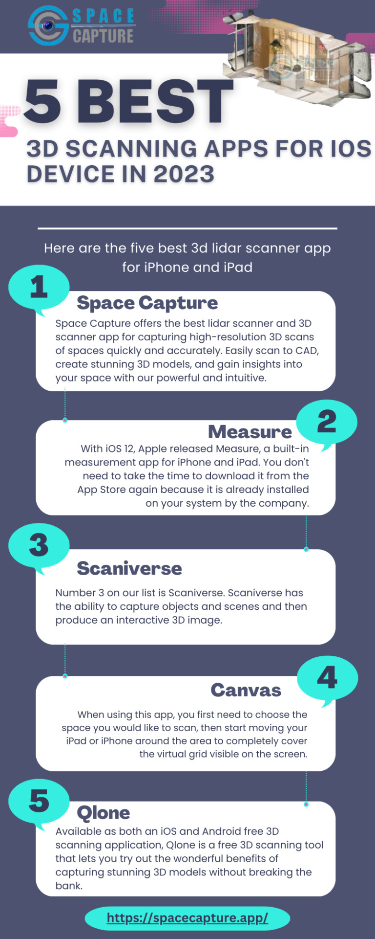
If you own the latest iPhone and do not use its LiDAR scan feature, you are missing out on a lot of amazing things. In order to map out three-dimensional spaces, the Light Detection and Ranging (LiDAR) scanner in the latest versions of the iPhone measures distance more precisely. Here are the list of five best Scanning App for iPhone and iPad.
#scanning app#room scanning app#3d lidar scanner app for iphone#3d lidar scanner app#best lidar scanner app#app
0 notes
Text
The Future is Lidar: Unlocking Possibilities with Precise Labeling

Lidar (which stands for Light Detection and Ranging) is a type of 3D sensing technology that uses laser light to measure distances and create detailed 3D maps of objects and environments. Lidar has a wide range of applications, including self-driving cars, robotics, virtual reality, and geospatial mapping.
Lidar works by emitting laser light pulses and measuring the time it takes for the light to bounce back after hitting an object or surface. This data is then used to create a precise 3D map of the surrounding environment, with detailed information about the size, shape, and distance of objects within the map. Lidar sensors can vary in their range and resolution, with some sensors able to measure distances up to several hundred meters, and others able to detect fine details as small as a few centimeters.
One of the primary applications of lidar is in autonomous vehicles, where lidar sensors can be used to create a detailed 3D map of the surrounding environment, allowing the vehicle to detect and avoid obstacles in real-time. Lidar is also used in robotics for navigation and obstacle avoidance, and in virtual reality for creating immersive, 3D environments. https://www.youtube.com/embed/BVRMh9NO9Cs
In addition, lidar is used in geospatial mapping and surveying, where it can be used to create highly accurate 3D maps of terrain and buildings for a variety of applications, including urban planning, disaster response, and natural resource management.
Overall, lidar is a powerful and versatile technology that is driving advances in a wide range of fields, from autonomous vehicles to robotics to geospatial mapping.
Choosing your labeling modality
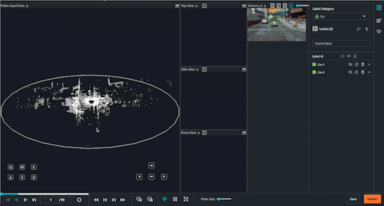
Object Tracking
Computer vision techniques are often used in combination with lidar 3D point cloud data to extract information and insights from the data. Here are some of the different computer vision techniques that can be used with lidar 3D point cloud data:
Object detection and recognition:-This involves using computer vision algorithms to detect and identify objects within the point cloud data, such as cars, buildings, and trees. Object detection and recognition can be useful for a wide range of applications, from urban planning to autonomous driving.
Object tracking:-This involves tracking the movement and trajectory of objects within the point cloud data over time. Object tracking can be used for applications such as crowd monitoring or autonomous vehicle navigation.
Segmentation:-This involves dividing the point cloud data into different segments based on the properties of the points, such as color or reflectivity. Segmentation can be used to identify regions of interest within the data, such as road surfaces or building facades.
Overall, these computer vision techniques can help to extract valuable information and insights from lidar 3D point cloud data and enable a wide range of applications and use cases. By combining lidar data with computer vision techniques, it is possible to create highly accurate and detailed 3D models of objects and environments, with a wide range of potential applications.
Why High-Quality labeling is important
High-quality lidar 3D point cloud labels are important for creating accurate and reliable 3D models of objects and environments. Here are some reasons why high-quality lidar 3D point cloud labels matter for a high-quality model:
Accuracy:-High-quality lidar 3D point cloud labels ensure that objects are accurately and consistently identified and labeled within the data. This is important for applications such as autonomous vehicles or robotics, where accurate and reliable information about objects in the environment is critical.
Consistency:-High-quality lidar 3D point cloud labels ensure that objects are labeled consistently across the data, with no variations in naming or identification. This is important for applications such as object detection or segmentation, where consistent labels are necessary for accurate and reliable results.
Completeness:-High-quality lidar 3D point cloud labels ensure that all objects within the data are identified and labeled, with no missing or incomplete information. This is important for applications such as geospatial mapping or urban planning, where complete and comprehensive information about objects in the environment is necessary.
Cost-effectiveness:-While high-quality lidar 3D point cloud labels may be more expensive to acquire or process initially, they can actually be more cost-effective in the long run, as they may require fewer resources to process or analyze and may be more suitable for a wider range of applications.
Overall, high-quality lidar 3D point cloud labels are critical for creating accurate and reliable 3D models of objects and environments, with a wide range of potential applications and benefits. By investing in high-quality labeling and processing, it is possible to create more accurate, detailed, and valuable 3D models that can be used in a wide range of applications, from autonomous vehicles to urban planning to robotics.
Best Practices to Manage Large Scale Lidar 3D Point Cloud Labeling Projects
Planning your lidar 3D point cloud labeling project is an important step in ensuring that the project is completed on time, on budget, and with the desired level of quality. Here are some key considerations to keep in mind when planning your lidar 3D point cloud labeling project:
Project scope:-Define the scope of the project, including the size of the dataset, the types of objects to be labeled, and the level of detail required. This will help to ensure that the project is focused and well-defined.
Labeling requirements:-Define the labeling requirements for the project, including the labeling schema, the labeling accuracy, and the level of detail required. This will help to ensure that the labeling process is consistent and produces high-quality results.
Labeling team:-Define the size and composition of the labeling team, including the number of labelers, their expertise, and their availability. Objectways can provide 1000s of trained Lidar labeling experts to match the throughput demand.
Tools and resources:-Identify the tools and resources required for the labeling project, including software, hardware, and data storage. This will help to ensure that the labeling process is efficient and that the results are consistent and of high quality.
Timeline and budget:-Define the timeline and budget for the labeling project, including the estimated time required for labeling, the cost of resources, and the expected deliverables. This will help to ensure that the project is completed on time and within budget.
Use Pre-labeling or downsampling to Save Cost:-There are many SOTA models available for pre-labeling that can provide starting point for labeling to save human labeling cost. Other approach in object tracking is to downsample frames at lower rate to reduce labeling effort
Overall, careful planning is key to the success of any lidar 3D point cloud labeling project. By taking the time to define the scope, requirements, team, tools, timeline, and budget for the project, it is possible to ensure that the project is completed with the desired level of quality and within the allotted resources.
At Objectways, we have worked on 100s of Lidar 3D point Cloud labeling projects across Autonomous Vehicles, Robotics, Agriculture and Geospatial domains. Contact Objectways for planning your next Lidar 3D point cloud labeling project
Lidar 3D Object Detection
Computer Vision
Autonomous Vehicle
Self Driving Cars
Tesla
#artificial intelligence#data annotation#data labeling#data science#machine learning#objectways#Lidar#Lidar 3d#Cloud Lableing#Cloud Labeling
0 notes
Last Seen Blogs

xiratudutiqu
Untitled

ipbpressbogor
Untitled
xiratudutiqu
Untitled
xiratudutiqu
Untitled

omegatechnology
omega technologies