#Catalan Atlas
Text

Doppelseite
Die Staatstafeln haben zwei Seiten. Die linke Seite zeigt das diplomatische Protokoll eines diplomatischen Protokolls. Warburg wahrt hier die aristotelische Einheit der Szene. Tafel 78 ist tabellarisch und kalendarisch organisiert. Auf der rechten Seite wahrt er die aristotelische Einheit nicht, er verwendet zwar auch eine tabellarische und kalendarische Gliederung, blendet aber eine elliptische Dynamik darüber. Warburg hat keine Einfälle, er hat Ausfälle. Er ist kein Asket, der denkt sich nichts aus. Er ist exzessiv und historischer Materialist. Er muss im Mnemosyne-Atlas in Fußnoten nicht angeben, dass es für die Doppelseiten Vorbilder gibt. Im Nach(t)leben der Antike ist alles Denkbare und damit traum(a)hafte schon passiert. Er muss nicht explizit Tafel 78 und Tafel 79 mit dem katalanischen Atlas assoziieren. Die ganze Welt ist ohnehin schizoid, das sagt Warburg an einer Stelle, wie in Stellvertretung, wie als pontifex minimus, für alle vereinigten Fußnotenvölker der Erde.
1 note
·
View note
Text

View at the Atlas - Magí Puig , 2023.
Catalan, b. 1966 -
Oil on canvas, 116 x 116 cm.
446 notes
·
View notes


Photo
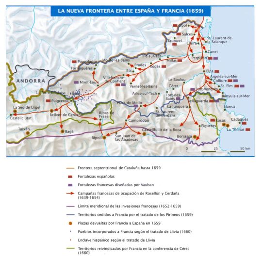
The new border between Spain and France, 1659.
via cartesdhistoire
Source: “Atlas de Historia de España”, Fdo García de Cortázar, Planeta, 2005
Within the framework of the Thirty Years' War, France declared war on Spain in May 1635. Starting in 1639, the French army invaded Roussillon, beginning with the occupation of the fortress of Salses. Richelieu fueled the revolt of the Catalans against Philip IV (started in June 1640), granting the insurgent leaders and troops the protection of French sovereignty (recognized by the insurgents in January 1641). Catalonia's return to Spanish obedience was effective only in October 1652 when Barcelona surrendered.
The fatigue produced by the French occupation, whose army was as burdensome or more burdensome than the Spanish and whose policy was more absolutist and inconsiderate than that of Olivares, alienated the population from the French, but Richelieu's move later served Louis XIV.
Indeed, the Peace of Westphalia (1648) did not put an end to the Franco-Spanish War, which ended with the defeat of Las Dunas (June 14, 1658). June 25, 1658, was the “folle journée” of neighboring Dunkirk: the city, Spanish in the morning, was taken by the French at noon and they handed it over to their ally England in the afternoon (it will be definitively French in 1662) .
The Peace of the Pyrenees (November 1659) meant the loss of Roussillon and Upper Cerdanya, with the establishment of the "dean border of Europe" between France and Spain. It also meant the definitive end of Spanish hegemony. On the other hand, one of the clauses of the treaty, which agreed to the marriage of Louis by a financially exhausted country), would later justify French interventionism in the Netherlands and, above all, would pave the way for the Spanish Crown to fall at the end of the century to the Bourbons, the current reigning dynasty in Spain.
50 notes
·
View notes
Text

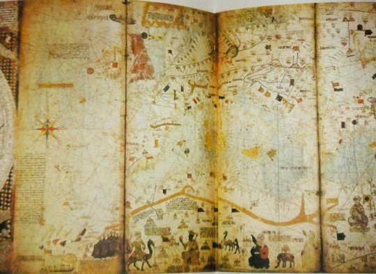
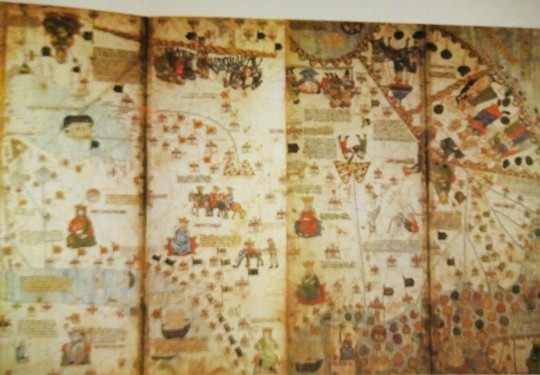
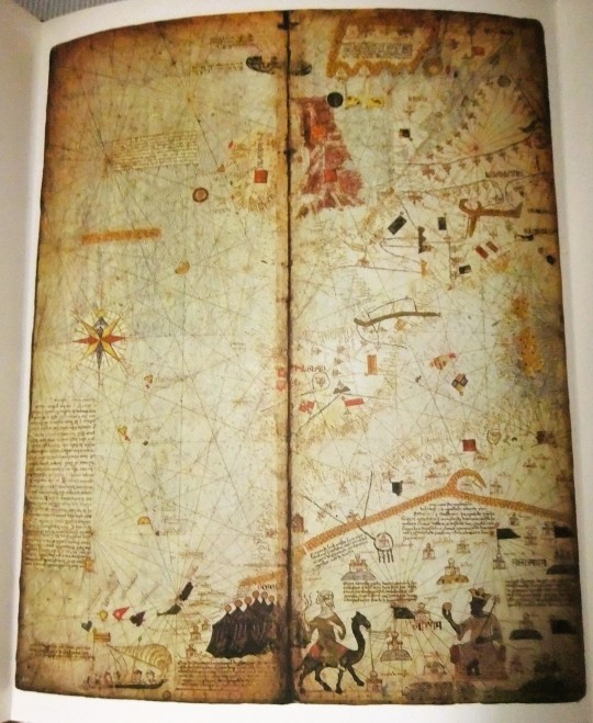
Depiction of the British Isles in the 1375 Catalan Atlas by Cresques Abraham.
180 notes
·
View notes
Text

"White Hydrangea". 2017.

"Big fràgil Black. lll".

"The Grid". 2023.

"View at the Atlas". 2023.

"Espitllera, Loophole". 2023.

"Palm Beach".
Paintings by Magi Puig. Catalan. b. 1964-
> Huariqueje.Tumblr
1 note
·
View note
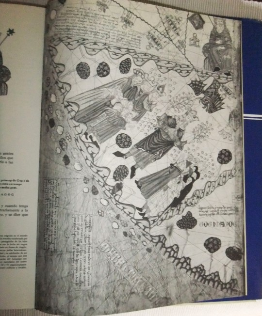
Text

Mansa Musa and the Sahara Desert on the Catalan Atlas of Abraham Cresques, Majorca, Spain, 1375. Paris, Bibliothèque nationale de France, Ms. Espagnol 30. Photo: Wikimedia Commons
2 notes
·
View notes
Note
Hey!! 5 different maps/map locations/styles for the ask game please!
THIS IS SO HARD OH MY GOD!!!! I'm sorry but I gotta go full nerd on this and it will be a long ass answer so i'm gonna put it bellow the cut
1. I REALLY love the Majorcan school of cartography, specially The Catalan Atlas because it incorporate lots of lines and iconography into the atlases, like it's pretty remarkable and they had such a big influence on medieval maps, its pure art
2. da Vinci's really accurate map of Imola, this dude was so crazy and genious that he drew a map with sattelite levels of accuracy and precision, it's so isane you can actually use it even today to navigate the city???? mindblowing!!!
3. I really love the comparative maps of river lengths and moutain heights, it also makes me giggle how precise they were with lots of rivers and they absolutelly got it SO wrong with the Amazon River
4. Miller Atlas because I'm so emotionaly attached to this map, but it is also because it is so rich, beautiful and actually tells us a story (like most maps), but this particular one tells a tale about a specific point of view of this group of people at the same time its sad prelude to what would come next in terms of colonization and stuff, also it's a good example of how the Majorcan School was so important in terms of style
5. The Great Polish Map of Scotland because it's so fucking random like can you imagine the insane work this guy did???? I love how different it is and I'm a slut for relief maps, specially in phisical forms
5 notes
·
View notes
Note
What do you think were the Violetta kids favorite shows growing up?
OH THIS IS MY LEAUGE, growing up in 00s Europe, we just got so much kids shows from all around the world, both new ones and re-runs from the 80s and 90s (also, of course, we got shows from our own countries).
Of course, I can't confirm every show aired in latin america, so what I'm doing is simply to see which ones had latin spanish dubs (also, of course I bet they liked shows from their own countries as well, but I don't know as much of LA-produced kids shows from the 90s and 00s - i'm better with the european, north american and japanese ones. Oh, and australian).
Either way!!
Violetta - so, she grew up in Europe, and in different countries, so she must've had such a VARIETY of kids shows. And I think, her favorite is an underrated fave of myself from when I was a kid - the catalan cartoon Les Tres Bessones (The Triplets). I think she'd like how the triplets always got sent into different stories and fairy tales by the witch and thought it was creative. It's likely she watched it while she lived somewhere in Spain (I mean, she has lived in Madrid and Barcelona, it's possible she has lived somewhere else there too during her childhood), because I know the cartoon was the most popular there, so she likely watched it with the spanish dub. Or, she watched it in catalan, what do I know. Or in a completely other language since I know it aired in other countries (I mean... that's how I know about it, it aired in my country)
Francesca - Am I too "stereotypical" for saying her favorite kids show was Winx Club? But like, Winx took ALL OF EUROPE by storm and I know it was obviously the biggest in Italy. And Fran would definitely be the right age when it came out too, around 8-9 years old.
Camila - I was about to say Creepschool, but I was unsure if that even airied in spanish speaking countries. Turns out, it did! Escuela de espanto. I think she'd really enjoy it due to the spooky and "not normative" vibes it had going on. Also, side note, but more or less every country got just that instrumental intro, while us in Sweden got someone singing the intro, and it was a BANGER.
Ludmila - SAILOR MOON. Space? Astronomy terms? Planet names? Girls fighting in short skirts? Ludmila got her awakening for EVERYTHING from this /j Also it may have been her first exposure to a lesbian couple in media
Naty - The moomins, the 90s anime specifically obviously (that is the most non-nordic people's exposure to the moomins). I know for a FACT the moomins anime aired in both Spain and Latin America, too. And I think Naty found it to be very comforting and cozy. Also I feel like her favorite character would be Little My, and she would later randomly call Ludmila that, making Ludmila reply with "I AM NOT LITTLE!!"
Leon - I feel like he really liked Recess. I feel like he thought the kids in that show were cool and he wished the recess in his own school was as fun.
Broduey - Arthur, simply because the intro is a little in that "soft vibes" music that Broduey likes. Also I think he enjoyed the humor.
Andres - Pokemon and you cannot change my mind. Except he managed to convince himself Pokemons were real and got VERY dissappointed.
Maxi - George Shrinks. You know, that cartoon about a boy that was really shrunk in size and had to adapt his life due to this. Came out in the year 2000. Idk, it just feels like something Maxi would like, I have no real reason why.
Diego - Honestly, ATLA. I can't think of much else.
Federico - JOHNNY BRAVO. No explantation.
I had a harder time with the boys than the girls lmao. But this was fun!
Also, do ask me about the SL characters too, cause they are implied to being born in the early 00s like me so it's easier for me to spot kids shows - as this time, I had to keep in mind like "ok, they may have been too old for this".
4 notes
·
View notes
Text
523-524 – Boethius writes The Consolation of Philosophy
525 – The Anno Domini calendar is invented
529-534 – Code of Justinian Issues
541-542 – Plague of Justinian
563 – St. Columba Founds Iona
590 – Gregory the Great Becomes Pope
618 – Tang Dynasty Begins
622 – Hegira
651 – Islamic Conquest of Persia
691 – Buddhism Becomes the State Religion of China
717-718 – Siege of Constantinople
747-750 – Abbasid Revolution
793 – Vikings Raid Lindisfarne
800 – Charlemagne Crowned Emperor
843 – Treaty of Verdun
862 – Rurik Dynasty in Russia
910 – Cluny Abbey Founded
911 – Foundation of Normandy
919 – First Use of Gunpowder
969 – Foundation of Cairo
979 – Song Dynasty Reunites China
1025 – Avicenna Writes the Canon of Medicine
1040 – Invention of Movable Type
1054 – Great Schism
1066 – Norman Conquest of England
1077 – Walk to Canossa
1084 – Zizhi Tongjian Published
1095 – The First Crusade Launched
1098 – Cistercians Founded
1135 – Gothic Buildings Emerge
1170-80 – Maimonides Writes Mishneh Torah
1206 – Chinggis Khan Becomes Ruler of the Mongols
1215 – Fourth Lateran Council
1215 – Magna Carta
1258 – Siege of Baghdad
1265 – Thomas Aquinas Begins His Summa Theologiae
1291 – Siege of Acre
1315-1317 – Great Famine
1320 – Dante Alighieri completes the Divine Comedy
1324-1325 – Pilgrimage to Mecca by Mansa Musa
1375 Catalan Atlas.
1337 – Beginning of the Hundred Years’ War
1347-1351 – Black Death
1368 – Ming Dynasty overthrows Yuan
1378 – Western Schism begins
1397 – Kalmar Union established
1401 – Competition for the Florence Baptister
1439 – Gutenberg invents printing press
1453 – Siege of Constantinople
1469 – Marriage between Ferdinand and Isabella
#medeival#middle ages#islamic golden age#black plague#chinese dynasties#european history#chinese history#catholic church#history#orthodox church#medieval church
0 notes
Text
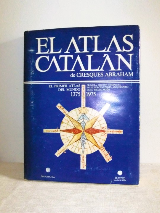
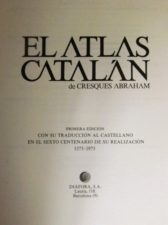
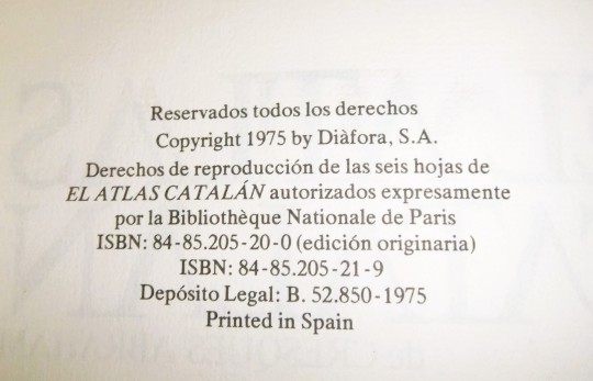

EL ATLAS CATALAN de CRESQUES ABRAHAM, 1375-1975 FACSIMIL
El Atlas Catalán de Cresques Abraham FUÉ EL PRIMER ATLAS DEL MUNDO , EDITADO EN EL AÑO 1375
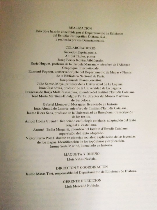
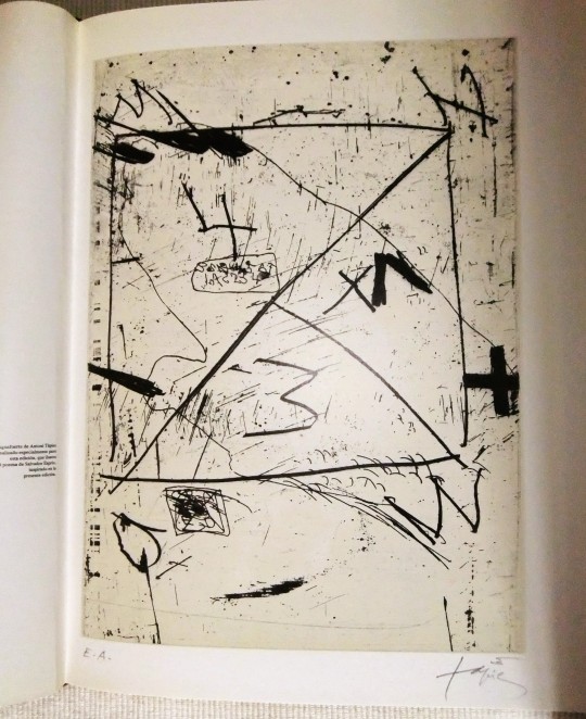
ILUSTRACIONES: Antoni Tápies
reproducción facsímil de los mapas originales en desplegables de hermosos acabados y reproduccción de un grabado de Antoni Tápies, firmado y signado EA, realizado exclusivamente para esta edición PROLOGO Y POEMA:
Prólogo de Josep Porter y un poema de Salvador Espriu AÑO: 1975 Reproducciones del original de 1375 PÁGINAS: 140 págs. EDITA: Diáfora, S.A. TAMAÑO: 33 x 24,5 cm
ENCUADERNACIÓN: Encuadernación en balasquín con sobrecubierta a 4 tintas. IDIOMA: Catalán/Castellano ESTADO: Buen estado.
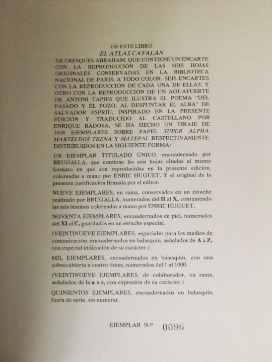
COMENTARIOS: Edición exclusiva limitada y numerada. Ofrecemos el número 96 de 1000 ejemplares.
Edición conmemorativa del 600 aniversario de la creación del atlas original (1375 - 1975).
Incluye:
Prólogo de Josep Porter, un poema del Salvador Espriu inspirado en esta edición acompañado de un aguafuerte facsímil de Antoni Tápies signado E.A., hecho especialmente para esta edición. Además, incluye una reproducción facsímil de los mapas originales en desplegables de hermosos acabados y una extensa explicación de los mismos.
El Atlas catalán o Mapamundi de los Cresques es un libro del siglo XIV que contiene varios mapas manuscritos que cubren todo el mundo conocido por los europeos de la época. Se conserva en la Biblioteca Nacional de Francia en París y es una de las obras cartográficas más importantes de la Edad Media.
Las fotografías forman parte de la descripción
140 € más gastos de envío
0 notes
Text

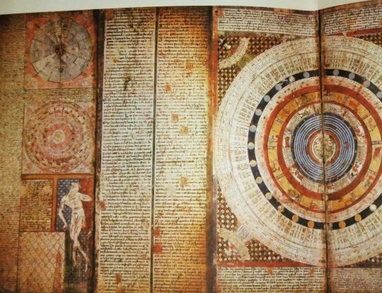
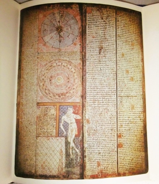
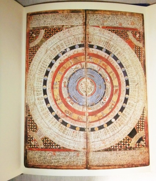
Der katalanische Atlas
Bevor Aby Warburg mit den Staatstafeln mitten in der Moderne dem Dogma der großen Trennung zwei Tafeln zugesellt, die sich an einen Gebot kannibalischer Metaphysik zu halten scheinen, weil sie großen Trennungen kleine Mannigfaltigkeiten entgegenstellen, haben die Schreiber und Zeichner des katalanischen Atlasses etwas ähnliches getan. Das katalanische Atlas entsteht zwar 600 Jahre vor dem Mnemosyne-Atlas. Er operiert aber diagrammatisch wie der Atlas, der 1929 zur dichten Summa und zum beweglichen Manual einer Bild- und Rechtswissenschaft unbeständiger, meteorologischer und polarer Normativität wird.
Die Ordnung des katalanischen Atlas' hält sich nicht an ein Regal, in dem Sprache, Schrift, Buchdruck und dann die Computisten und Nettwerkler die Legende vom Westen hochstapeln, um später zu erklären, warum der Westen einen Vorsprung durch Technik oder ein Vorrecht durch Menschenrechte hätte. Der Atlas operiert wie ein Möbel, nicht wie ein Haus, wo das Dach immer oben und der Keller immer unten ist. Er operiert wie ein Ball, wo oben auch mal unten ist und umgekehrt. Der Atlas ist bolisches Objekt. Entweder geht man um den Atlas herum, oder man dreht ihn um. Entweder dreht man sich oder ihn.
Die diagrammatische Technik operiert mit Diagrammen, also mit Zeichen, die durchgehen/ passieren, und die durchgehen oder passieren, weil sie kreuzen. Diagramme trennen auch, sie assoziieren auch, sie halten die Elemente aus austauschbar. Aber sie operationalisieren einen Pendelverkehr, etwas, was in alle Richtungen sich wenden kann.
0 notes
Text


catalan atlas like someones potential son
0 notes
Text
The Catalan Atlas of 1375 inspired Henry to organize expeditions to find new trade routes to Africa that bypassed land routes in Italy that were controlled by powerful city-states like Genoa, Florence, Milan, Naples, Venice, and Naples.
He also wanted to find the eastern kingdom of the legendary Christian king, Prester John. Henry and others hoped that by uniting with Prester John, the Christian kingdoms in Europe could defeat their Muslim adversaries during the Crusades. In 1420, he was appointed the Grand Master of the Order of Christ.
Prince Henry earned his title “the Navigator” because he assembled a learned group of designers and maritime experts to design new ships, maps, and navigational instruments. Henry then funded expeditions to use this knowledge to sail the High Seas and explore the West African coast.
Over time, he sent 14 expeditions south toward Africa to explore what was known as the “Sea of Darkness.” Building up a massive body of maritime know-how with each expedition, Henry oversaw the first stages of a process that helped Portugal build a global empire.
Slavery of Africans started in 1420 and again in the later expedition of 1441 to bring African slaves to the new world, of course the first groups were indentured servants that were granted land at the end of their contracts because chattel slavery didn't start until Anthony Johnson a Black Indentured Servant himself won a case against run-away slaves which were considered as Black and white is when slavery became race related even though race wasn't official until after Bacon's Rebellion. 1619 is really a falsehood because slavery started when the Europeans first set sail.
0 notes
Video
ATLAS CATALAN COMPARADO A OTROS MAPAS Y UN POCO DEL PRESTE JUAN
0 notes
Text
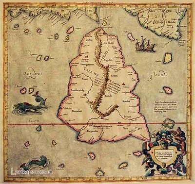
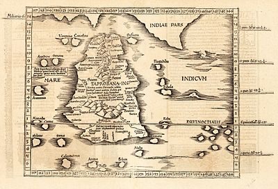
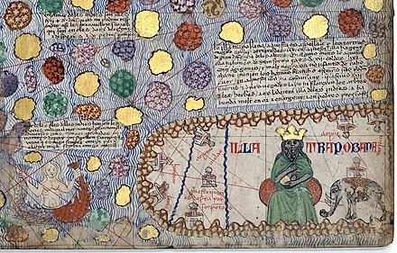
Three different maps of Taprobane Island
modern Sri Lanka,
as known to the Ancient Greeks
1. Ptolemy's Taprobane
2. Ptolemy's Taprobana published in Cosmographia Claudii Ptolomaei Alexandrini (1535)
3. Taprobane in the Catalan Atlas (1375): "Illa Trapobana"
#art#archaeology#maps#medieval#ancient#taprobana#taprobane#taprobane island#taprobana island#sri lanka#1500s#1300s#16th century#14th century#geography
1 note
·
View note
Last Seen Blogs

jnmetalparts
Jinan Meierde

theryanpatterson
The Ryan Patterson

chaseboel77
The Life of Skovsgaard 815

mysnyez
无标题

granny-fullback-panties3
Granny Panties Round 3!!