#Chuska Mountains
Video
flickr
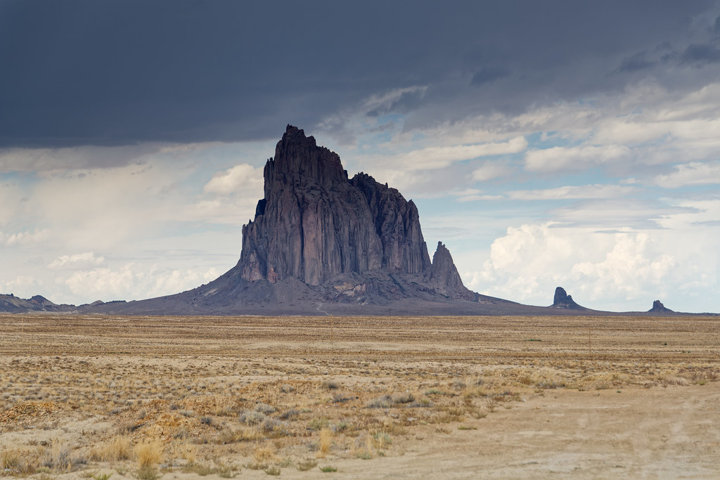
Shiprock and a Look Across the New Mexico High Desert by Mark Stevens
Via Flickr:
A setting looking to the northwest while taking in views across the northern New Mexico high desert with a distant view to the Shiprock formation. This is at a roadside pullout along Indian Service Rte 13. With this image, I pulled back on the focal length to include more of the surrounding landscape to add to the setting in the image captured.
#Azimuth 320#Blue Skies#Blue Skies with Clouds#Chuska Mountains#Colorado Plateau#Day 3#Desert Landscape#Desert Mountain Landscape#Desert Plant Lifes#Diatreme#DxO PhotoLab 7 Edited#Erosional Landscape#High Desert#Igneous Rock#Indian Service Rte 13#Intermountain West#Landscape#Landscape - Scenery#Looking NW#Monadnock#Mostly Cloudy#Nature#Navajo Area#Navajo Volcanic Field#New Mexico and Mesa Verde National Park#Nikon D850#No People#Outside#Partly Cloudy#Partly Sunny
4 notes
·
View notes
Photo
Canyon de Chelly
Canyon de Chelly or Canyon de Chelly National Monument is a protected site that contains the remains of 5,000 years of Native American inhabitation. Canyon de Chelly is located in the northeastern portion of the US state of Arizona within the Navajo Nation and not too far from the border with neighboring New Mexico. It is located 472 km (293 miles) northwest of Phoenix, Arizona. Canyon de Chelly is unique in the United States as it preserves the ruins and rock art of indigenous peoples that lived in the region for centuries - the Ancestral Puebloans and the Navajo. Canyon de Chelly has been recognized as a US National Monument since 1931 CE, and it is one of the most visited National Monuments in the United States today.
Geography & Prehistory
The etymology of Canyon de Chelly's name is unusual in the U.S. Southwest as it initially appears to resemble French rather than the more ubiquitous Spanish. "Chelly" is actually derived from the Navajo word tseg, which means "rock canyon" or "in a canyon." Spanish explorers and government officials began to utilize a "Chelly,” “Chegui,” and even "Chelle" in order to try to replicate the Navajo word in the early 1800s CE, which eventually was standardized to “de Chelly” by the middle of the 19th century CE.
Canyon de Chelly lies very close to Chinle, Arizona, and it is located between the Ancestral Puebloan ruins of Betakin and Kiet Siel in the west and the grand structures of Chaco Canyon in New Mexico in the east. Canyon de Chelly, as a National Monument, covers 83,840 acres (339.3 km2; 131.0 sq miles) of land that is currently owned by the Navajo tribe. Spectacularly situated on the Colorado Plateau near the Four Corner's Region, Canyon de Chelly sits at an elevation of over 1829 m (6,000 ft) and bisects the Defiance Plateau in eastern Arizona. The tributaries of the Chinle Creek, which runs through Canyon de Chelly and originates in the Chuska Mountains, have carved the rock and landscape for thousands of years, creating red cliffs that rise up an additional 305 m (1000 ft). The National Monument extends into the canyons of de Chelly, del Muerto, and Monument.
Canyon de Chelly is one of the longest continuously inhabited places anywhere in North America, and archaeologists believe that human settlement in the canyon dates back some 5,000 years. Ancient prehistoric tribes and peoples utilized the canyon while hunting and migrating seasonally, but they did not construct permanent settlements within the canyon. Nonetheless, these prehistoric peoples did leave etchings on stones and on canyon walls throughout what is now Canyon de Chelly. Around c. 200-100 BCE, peoples following a semi-agricultural and sedentary way of life began to inhabit the canyon. (Archaeologists refer to these peoples as "Basketmakers." They are considered the ancestors to the Ancestral Puebloan Peoples.) While they still hunted and gathered like their prehistoric forebears, they also farmed the land where fertile, growing corn, beans, squash, and other small crops. It is also known that they grew cotton for textile production. Yucca and grama grass have grown in the canyon for several millennia, and indigenous people utilized these plants when making baskets, sandals, and various types of mats. Prickly pear cactus (Opuntia cactaceae) and pinyon are also found throughout Canyon de Chelly, the latter of which provided an important source of food for indigenous peoples in autumn and winter. Fish are found in Canyon de Chelly's tributaries, and large and small game frequent the canyon.
Continue reading...
50 notes
·
View notes
Text

This past weekend, I took Kewanee with me on a camping trip, so that she and I could get to know each other better.

Kewanee is new here, and I haven't done much with her yet. But I know she's the type of kid who is always in the mood for an adventure.

I brought along her tent and her camp stove. The tent is American Girl brand, and the stove was made by me. It can only hold a pretend fire, but I gathered a few "logs" for it anyway so Kewanee felt included. Here's the post where I explain how I made it.
The next day, we got up and headed out for part 2 of our adventure!

We drove northwest to reach Narbona Pass, in the Chuska and the Tunicha mountains, on the Navajo Nation. The drive up is quite spectacular--you start out in a rather barren desert, and when you've gone up the summit you're suddenly in tall forests of spruce and aspen trees! In the middle of the above photo, you can see the pink and yellow desert below the trees. It's like driving from Mexico to Canada, but the trip only takes a few minutes instead of several days.

This was the highest point of the pass. The flowery meadows were so beautiful!
We continued to follow the road going west as it went downhill. The road eventually leveled out as it turned south, where we saw the most beautiful red rock formations.

I know Kewanee is still feeling a little homesick for Michigan, where she's from. But the lovely scenery passing us by at every moment helped her feel better about her new home here. This is only a small sample of the natural beauty she'll see.


If you ask me, it doesn't get better than this, at least not on any known planet in any solar system! Maybe one day she'll agree with me about that.
16 notes
·
View notes
Text
As it gets hotter, 13,000 families in this pocket of America live without electricity
Katherine Benally sat between two open windows in her small home and looked out over a sun-baked field in the Chuska Mountain foothills of the vast Navajo Nation.
As she waited for the cooling cross breeze, the 74-year-old recalled fondly the days when her family grew squash, corn and pumpkin on this property. They sought shade under its trees and had no need for electricity or other modern…
0 notes
Text
Down Chuska Mountain
By: Jeffrey Delano Davis
The wind screams through the pickup. It tosses rusted bolts, fence wire, wrenches, and Sike’s feed bowl about the cargo bed with alarming ferocity. Nina rubs flints of plywood and sheep hair from her watering eyes. She grips Sike’s collar with one hand, the wheel with the other. The pair pop up and down in their seats as the chassis rocks over potholes. The wheels crush…

View On WordPress
0 notes
Text
The First Day of a New Life: Four Corners - A Photo Essay

View On WordPress
#arches national park#chuska mountains#colorado#lasal mountains#new mexico#park avenue#petrified dunes#scenic highway 64#shiprock#utah
1 note
·
View note
Photo

Chuska Mountains, Navajo Nation, U.S.A. [OC][3057x1959] via /r/EarthPorn https://ift.tt/2yCKDFA
31 notes
·
View notes
Text
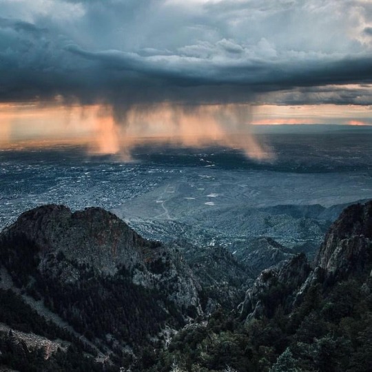
A cloudburst over Albuquerque viewed from the Sandia Crest. Photo: Estevan Robles (Aug 4, 2022) :: [Scott Horton]
* * * *
They took the road that wanders over Washington Pass via Red Lake, Crystal, and Sheep Springs. Winding down the east slope of the Chuskas, Leaphorn stopped at an overlook. He pointed east and swept his hand northward, encompassing an immensity of rolling tan and gray grasslands. Zuni Mountains to the south, Jemez Mountains to the east, and far to the north the snowy San Juans in Colorado. “Dinetah,” he said. She would know the meaning of the word. “Among the People.” The heartland of the Navajos. The place of their mythology, the Holy Land of the Dinee. How would she react?
[Coyote Waits (Leaphorn & Chee #10)by Tony Hillerman]
#Scott Horton#Albuquerque#New Mexico#Sandia Crest#Estevan Robles#Leaphorn & Chee#Tony Hillerman#quotes#Dinetah#Coyote Waits
30 notes
·
View notes
Photo

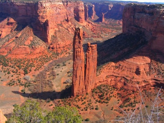
Red Rock needles north of Gallup...Cleopatra's Needle and the Venus needle. Cleopatra's Needle is one of the skinniest sandstone spires in the world. The route through Window Rock and the Chuska Mountains is pretty. (at Gallup, New Mexico) https://www.instagram.com/p/B9Plhi1nYKe/?igshid=1l1i390oh5d4t
25 notes
·
View notes
Video

flickr
A Distant View Across Colorado to Shiprock (Mesa Verde National Park) by Mark Stevens
Via Flickr:
A view looking to the southwest to a distant Shiprock at Park Point Lookout in Mesa Verde National Park. Even while zooming in with the focal length, I was able to still capture some of the surrounding national park landscape to add to this setting with the image.
#Ancestral Puebloan#Ancestral Puebloan Archaeological Sites#Archaeological Preserve#Archaeological Sites#Azimuth 214#Blue Skies#Blues Skies with Clouds#Chuska Mountains#Colorado Plateau#Day 5#Desert Landscape#Desert Mountain Landscape#Desert Plant Life#Desert Plant Lifes#Diatreme#DxO PhotoLab 7 Edited#Erosional Landscape#High Desert#Igneous Rock#Intermountain West#Landscape#Landscape - Scenery#Looking SW#Mesa Verde National Park#Monadnock#Mostly Navajo Area#Mountain Peak#Mountains#Mountains in Distance#Mountains off in Distance
1 note
·
View note
Photo

Chuska Mountains, Navajo Nation, U.S.A. [OC][3057x1959] Check this blog!
33 notes
·
View notes

Photo

Chuska Mountains, Navajo Nation, U.S.A. [OC][3057x1959]
3 notes
·
View notes
Photo

Chuska Mountains, Navajo Nation, U.S.A. [OC][3057x1959] by lethrwawy
2 notes
·
View notes
Photo

Chuska Mountains, Navajo Nation, U.S.A. [OC][3057x1959]
1 note
·
View note
Last Seen Blogs

cascadebarcourtyardchchnz
Untitled

timeless-the-alchemist
aka the best fangirl

outsourcedataworks
Outsourcing Simplified

amazecreative7
Amaze Creative

69womanlover69
Female Form Appreciation