#Fantasy World Map
Photo


Since I’m a normal person and this idea would not leave my head, I spend the whole afternoon making a Shrek’s world map with all the places we see in the full Shrek’s franchise (including Puss in Boots spinoffs)
It's obviously derivative from our world. I tried to make it make sense between what the places look like in the movies and the travelling the characters seems to be doing between each places.
The places Shrek goes to looks like western europe/USA inspired, while Puss in Boots movies and series looks like a mix between Spain, south of US, and Mexico, so I tried to blend all the inspirations.
Feel free to comment of stuff that doesn’t make sense or I might have missed.
#shrek#puss in boots#fantasy world map#fiona#donkey#farquaad#fairy godmother#goldilocks#merlin#arthur#3 diablos#dulcinea#the adventures of puss in boots#9 lives and 40 thieves#the trident#dreamworks#big jack horner
275 notes
·
View notes
Text

Hello everyone! I am a game/dungeon master with a huge, elaborate world in the Dungeons and Dragons multiverse, and this is a map of my world - Atona.
I am currently writing a guide to this world and a set of stories so that everyone can start their adventures in it.
You can support me on this long and thorny path on my boosty page.
12 notes
·
View notes
Text
Map of Anthwahan
hand-drawn and homebrew for 5e

please zoom in! every blade of grass and tree in forests was drawn individually.
#dnd#dungeons and dragons#homebrew dnd#dnd homebrew#dnd 5e#dnd map#dnd maps#fantasy world#fantasy world map#fantasy map#map art#dnd campaign#homebrew campaign#took ten months#isnt it neat
58 notes
·
View notes
Photo


Map of the Convergent Plane
New version of old map I made in inkarnate. I’m thinking about starting a new campaign soon
#map#worldmap#dnd map#dnd worldbuilding#inkarnate#mapmaking#fantasy map#fantasy world map#dnd#dnd art#mapmaker#cartography#fantasy cartography#fantasy world#fantasy worldbuilding#dnd plane
63 notes
·
View notes
Text

A world coming to life ⚡️🐉🔥🐍❄️
After 3 years, my sister, @theblackcrow-13 ‘s story is taking a step forward and I am glad to be part of it.
#books#reading#bookdragon#livros#witches#oc#oc story#original character#original story#fantasy#fantasy world#fantasy map#shadows#made up#dragons#percivalemryn#calliope#calliopehavard#ellasandradelvaux#dravenwestergaard#zevranforsberg#amateur writer#fantasy world map
6 notes
·
View notes
Text
I said I had a map, so here's the map.
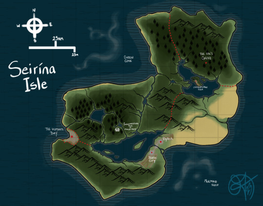
Seirína Isle is where Mailo, Ribbon, and Jeriko are from.
It's a small island about the size of irl Puerto Rico.
It's primarily populated by magical beings (beastman, Fairies, mermaids, sirens etc) the main dominant beings are Fae and Sirens.
There are only 3 real cities on the island, primarily used by beastmen and magic using humans.
The Humans bay: Made and used by magicless human, this area is the only area they are allowed to be as they are seen as an invasive species and aren't welcome. They do do trading with the locals but the locals are the only ones going in and out of their city. Any magicless humans who leave the bay are actively hunted down an eliminated.
Trade City: The central hub for islands in habitats to trade goods. It's a flourishing city where mostly magic using humans live. It's a safe haven due to all of them being persecuted and hunted by magicless humans.
Dyrisk: Beastman city basically, a large majority of the beastman population lives here.
The island isn't split up into states it's mostly nameless territories. The Fae control the northeastern part of the island, southeast are the Beastman, southwest the magical humans, and the largest territory(land and sea) is controlled by the Sirens.
Because of the Sirens having the largest territory on the island it was named after them.
The waters around the island is heavily patrolled by the Sirens so they limit the amount of humans who come in.
There are Mermaids that live near the island but they mostly live towards the south because Siren will hunt them. (Sirens are very aggressive)
Hope ya enjoyed this blip
9 notes
·
View notes
Text
This is not AI art, but rather a map of part of my World of Asdar that I made in Freehand, a vector-based art program. I designed all the coasts and continents that you see above. There's actually quite a lot more of the map not shown. This is just a little part that I work on the most. It is roughly equivalent to Europe, North Africa, and the Middle East.
#World of Asdar#Map#Fantasy World#Fantasy World Map#Asdar#Pytharnia#Barathorn#Corundy#Lucacia#Nymentho#Erechóreb#Erechoreb#Ambrinqua#Weshif#Danona#Skerrod#Midrardia#Osfanfia#Jaggudorns#Shelekhumbia#Addamantines#Pallathantic#Glaye#non-AI#non-MJ
4 notes
·
View notes
Text
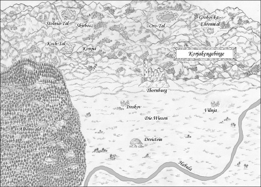
14. November 2023
Ich durfte mal wieder eine Fantasylandkarte zeichnen, für »Berge des Winters: Flammende Zeichen« von Jaro Zohar.
Davon handelt der High Fantasy Roman, der gerade frisch erschienen ist:
Der Dreiklang des Schicksals: Glaube, Magie, Krieg.
Über dem idyllischen Korjakengebirge ziehen düstere Wolken auf. Elija, ein junger Priester und zukünftiger Anführer seiner Sippe, soll einen erbarmungslosen Feind aufhalten, der alle Menschen des Gebirges bedroht. Elijas Weg führt ihn in die Wirren eines uralten Konflikts, der die drei Sippen der Berge entzweit hat. Doch nicht nur äußere Feinde bedrohen Elija, sondern auch der Zweifel an seiner eigenen Bestimmung.
Währenddessen formt sich eine unerklärliche Magie, geflochten mit den Fäden des Verrats. Die begabte junge Frau Chenka erfährt von einer geheimnisvollen Fehde zwischen den mächtigen Ahnen des Gebirges. Die Kunst der Glyphenbinderei, die sie erlernt, entpuppt sich als Schlüssel in einem gefährlichen Spiel, das alle drei Sippen bedroht.
Die Sippen müssen sich vereinen, um der herannahenden Gefahr zu trotzen. Doch Misstrauen und Hass erschweren die Zusammenarbeit. Während Elija verzweifelt versucht, die Pruzzen, eine stolze
Kriegergemeinschaft, zu überzeugen, offenbart sich Chenkas wahres Potenzial im Kampf gegen den Feind.
In einem epischen Finale vor der belagerten Heimatburg wird deutlich, dass der wahre Feind nicht vor den Mauern steht, sondern in dem jahrhundertealten Konflikt zwischen den mächtigen Ahnen der Sippen.
Können Chenka und Elija die Balance zwischen Glaube, Magie und Krieg wahren?
🏔️ ❄️
Link zum Buch auf Amazon: https://www.amazon.de/dp/B0CNCGYFV8
Die Webseite: https://www.bergedeswinters.de/das-buch/
#High Fantasy#Berge des Winters Flammende Zeichen#Jaro Zohar#Debütroman#High Fantasy Roman#Fantasylandkarte#Illustration#Illustrationen#artists on tumblr#fantasy world maps#fantasy world map#Phantastik#buch tumblr#lesen#leseliebe#buchtumblr#Fantasyroman#fantasy world#fantasy#zeichnung
2 notes
·
View notes
Text
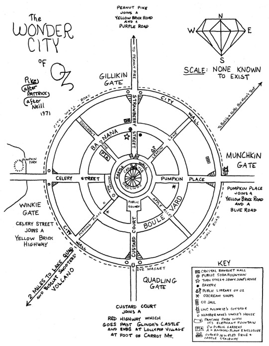
Oz’s Emerald City fluctuates from book to book and author to author, so there’s no real concrete description about the place (is the green color just the result of people wearing green glasses? Is it actually green?).
I came across this drawing by Judy Pike from the 1970s, though, based on descriptions from the book. It’s the most concrete map of the place I could find so far.
Most people think of Oz as being perpetually stuck at the turn of the 20th Century, but I’ve noticed that even in the original books new technologies were present (Tik-Tok, the mecha that guards the Nome King’s kingdom, even stuff like phones and power lines in some of the illustrations). I kind of want to extrapolate on that in my writing.
#the wonderful wizard of oz#l frank baum#judy pike#the emerald city#emerald city#my post#map#fantasy world map
10 notes
·
View notes
Text
Experimenting with sharpness, coloration and brushes for map-making.

#mapmaking#maps#fantasy world map#fantasy map#fantasy setting#worldbuilding maps#mapbuilding#worldbuilding
3 notes
·
View notes
Text
A map of the world valmoris

#my art#digital art#artists on tumblr#art#lineless style#lineless art#map#my map#world map#fantasy world map
4 notes
·
View notes
Text
This came across my Facebook feed, felt I’d share it.
49K notes
·
View notes
Text


WORLD BUILDING
WORLD BUILDING
WORLD BUILDING
WORLD BUILDING
This is my favorite part of any story smhhh like climate maps? Population maps? Labeled maps? It's my fuckin jam. This isn't gonna be for any actual written story, it's just for a story in my head. The sole author/director/audience all in one ♡
It's gonna have all my favorite things! Twisted moral-less gods, cult themes, cannibalism, ritual sacrifice~
#PLEASE please please send me asks about this world I'm frothing at the mouth with information#original world#World map#Fantasy world#Fantasy world map#Original world map#Fantasy map#Climate map#Wealth map#Population map#Dragon world#You wouldn't believe how long I've been staring at climate and population maps online#Just for references#At first the planet was gonna be bigger than earth#But mass correlates directly with gravity#So a larger planet would have more intense gravity ofc. That would get in the way of flying lol#So now it's a little bit smaller than earth!#World building#My works
1 note
·
View note
Text
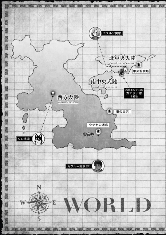
Dungeon Meshi World Map
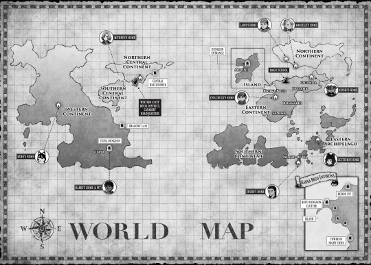
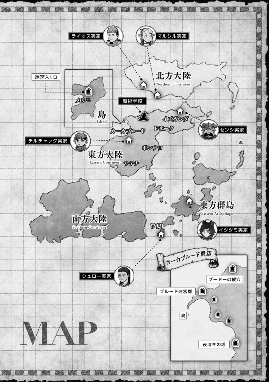
REGIONS (Descriptions taken from the Adventurer's Bible)
WESTERN CONTINENT
Description: Bears the most scars from the ancient war. It has many monsters and ruined dungeons, and although it's vast, there are surprisingly few habitable areas. Most of the inhabitants are sturdy, short-lived races and demihumans. Elven culture has had a strong influence here.
Characters: Kabru and Kuro
Places of Note: Utaya
Dungeons of Note: The Utaya Dungeon, The Dragon's Lair
NORTHERN CENTRAL CONTINENT
Description: The continent that is home to the largest nation, ruled by the queen of the elves. The term "Western Elves" mostly indicates elves from this region. It's the safest area and life is easy here, but its shrinking population has dangerously weakened it.
Characters: Mithrun (and the Canaries)
Places of Note: Western Elves's Royal District, Canarie's Headquarters.
Dungeons of Note: Central Watchtower
SOUTHERN CENTRAL CONTINENT
Description: The area with the second-largest elf nation. It has more inbound immigration than the Northern Central Continent and a rather disorganized atmosphere. While it's in an alliance with the Northern Central Continent, they really aren't on good terms.
Characters: -
Places of Note: -
Dungeons of Note: -
EASTERN CONTINENT
Description: Home to the largest gnome nation. Once dwarfs and
gnomes made up the majority of the inhabitants, but in recent years there has been an influx of short-lived races from the Northern Continent and Eastern Archipelago, and the population is growing rapidly. It's a melting pot where various cultures are jumbled together.
Characters: Chilchuck Tims (Kahka Brud), Senshi (Izganda)
Places of Note: Magic School, The Island/Melini, Kahka Brud, Izganda, Dozahk, Bonnario, Sadena
Dungeons of Note: Island, Brud Dungeon Cluster, Budou Pit, Tower of Night Cries
NORTHERN CONTINENT
Description: A severely cold continent where over half of the land is covered in perpetual snow. The majority of the inhabitants are short-lived races, particularly tall-men, but the population isn't large to begin with. It has been strongly influenced by dwarf culture.
Characters: Laios & Falin, Marcille
Places of Note: -
Dungeons of Note: -
EASTERN ARCHIPELAGO
Description: An area where short-lived races live. As a result of a pact, there has been no interference by long-lived races for a very long time. The effects of the ancient war are slight, and they have almost no trouble with monsters or dungeons, but there's constant strife among humans.
Characters: (all from different Islands) Izutsumi, Shuro and his Retainers, Rinsha Fana (Not shown)
Places of Note: Island of Wa
Dungeons of Note: -
SOUTHERN CONTINENT
Description: Home to the largest dwarf city. Gnome and dwarf nations often build down rather than out, and the innermost layers are extraordinarily deep. War still erupts frequently, and there are never-ending disputes near the borders.
Characters: -
Places of Note: -
Dungeons of Note: -
If you're interested I've found a post on pixiv with the map outlines and some more info (in japanese)
I'll make a post about the dungeon descriptions later but here they are, there's a little more info about Kahka Brud dungeons on my last map post
1 The Island, 2 Budou Pit, 3 The Brud Dungeon Cluster, 4 The tower of Night Cries 5 The Utaya Dungeon 6 The Dragon's Lair 7 The Central Watchtower
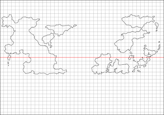
Map Outline
#dungeon meshi#dungeon meshi map#adventurers bible#maps#world map#Laios Touden#Marcille Donato#Senshi of Izganda#Chilchuck tims#Izutsumi#Toshiro Nakamoto#Kuro#Kabru of utaya#Utaya#The canaries#Mithrun#Edit: Shame on me I forgot to add one more map and a link to a pixiv post with the outlines#longpost#long post#worldbuilding#world building#fantasy map#fantasy world#for referencing
1K notes
·
View notes
Text
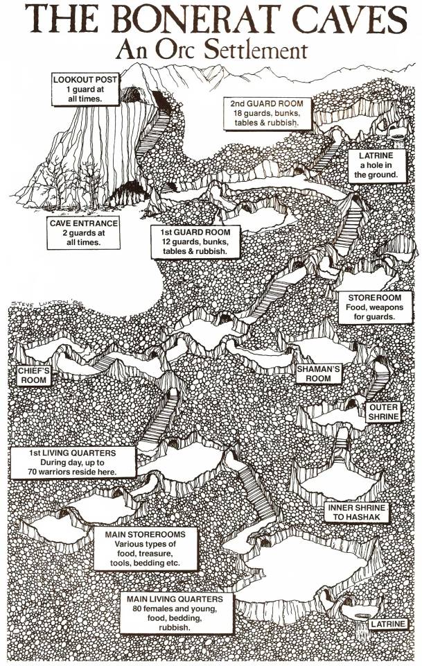
The Bonerat Caves, an orc settlement (Titan: The Fighting Fantasy World, by Steve Jackson and Ian Livingstone, Puffin Books, 1986)
#Fighting Fantasy#dungeon#Titan: The Fighting Fantasy World#dungeon map#orcs#fantasy#cave#cavern#Steve Jackson#Steve Jackson UK#Ian Livingstone#The Bonerat Caves
734 notes
·
View notes
Text

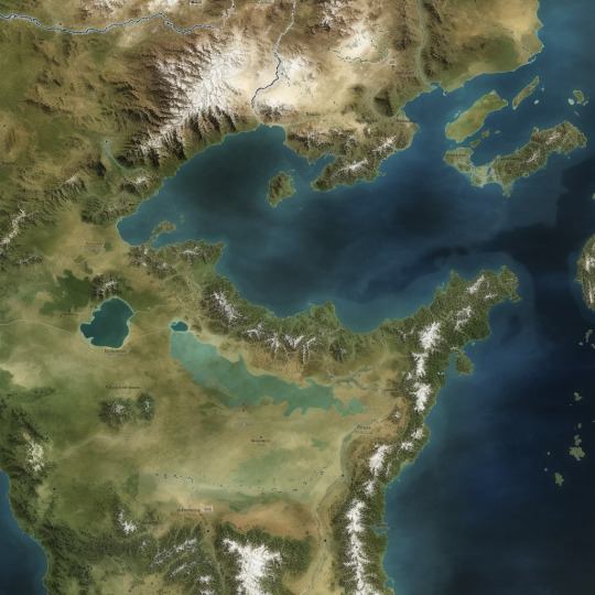


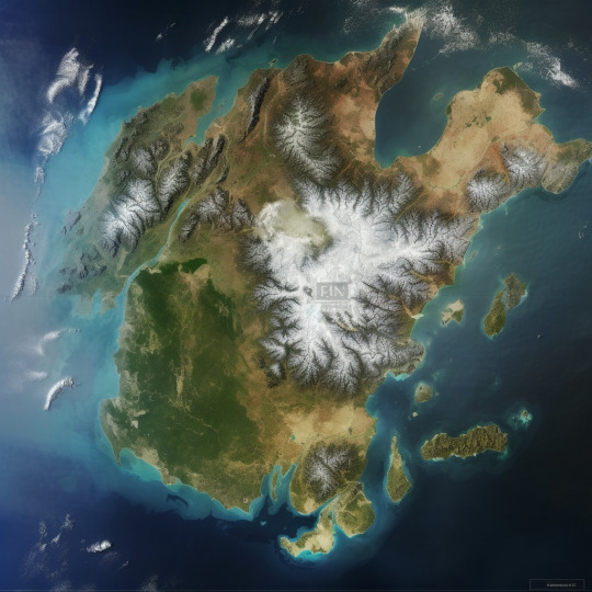
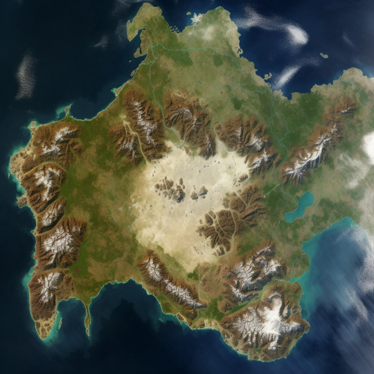
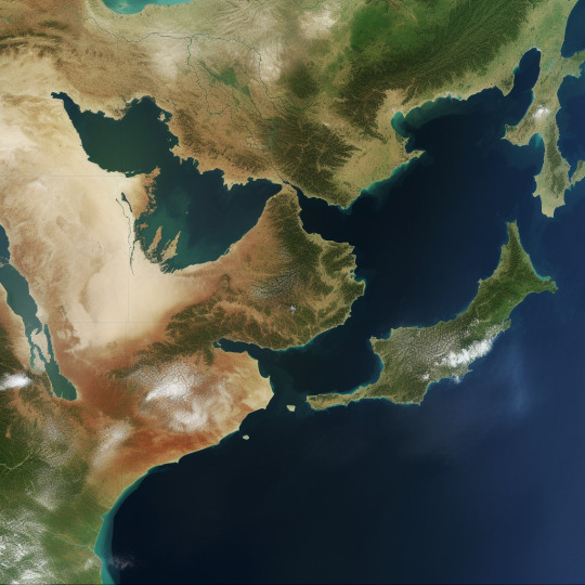
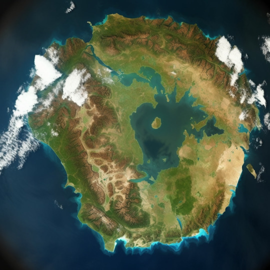


Did you know you can use AI to make fantasy world maps?
I used the /blend function with satellite images, mainly of Europe and parts of Europe. Then I used /imagine with a fairly basic command to make a 'fantasy map.'
The results speak for themselves.
I have quite a few more. The fact that I haven't posted them doesn't mean they were poorer. There are just too many.
Nevertheless, you can still see where real world geography pokes through. The outline of Arabia is obvious in at least two maps and you can see where the Japanese Islands and the Korean Peninsula were the source maps for an eastern coastline.
By Midjourney
#AI Art#Midjourney#satellite image#image blend#fantasy world map#world map#fantasy map#Asdaricus MJ Fantasy World Map
8 notes
·
View notes
Last Seen Blogs

kirstydreaming
feminine inspiration
fureimuhiro
FLAME HERO

laparisienneadublin
Parisian in Dublin

pineapple-and-fitspiration-blog
I'm addicted to healthy food and attractive body!

panaiero
Panaiero