#Geospatial Commission
Explore tagged Tumblr posts
Visit Tumblr Blog
Explore Tumblr blogs with no restrictions, modern design and the best experience.
Last Seen Tumblr Blogs


Fun Fact
Tumblr has been banned in Indonesia for providing people with access to pornographic content.
Text
FOI release: discussion paper on Measuring Impact of the Geospatial Commission
Post: 8 August 2024
New blog post on my website:
FOI release: discussion paper on Measuring Impact of the Geospatial Commission
0 notes
Text
During a press conference in the Oval Office late last month, US President Donald Trump doubled down on his plan to build a massive new missile defense system largely based in space he is calling the “Golden Dome.” In recent weeks, defense companies have begun vying for anticipated government contracts tied to the project, and three firms with deep connections to the White House—SpaceX, Palantir, and Anduril—have been named as purported frontrunners.
Trump ordered plans to be drawn up for the Golden Dome within days of returning to office in January, and he said in May that it would be operational by the end of his term in January 2029. But behind the scenes over the past few months, competing defense companies and industry experts have told WIRED the future of the project isn’t certain.
They say it’s still unclear whether the missile shield could be constructed in space the way Trump wants and how many contracts will ultimately be awarded. Trump recently claimed that he had selected a $175 billion design for the shield, but some experts expect the cost to be far greater, and question how it will be paid for.
Although it has been compared to Israel’s Iron Dome missile defense system, some sources noted that a project of the Golden Dome’s size and scope has never been built before. “The Manhattan Project element of this is just simply the scale,” says John Clark, senior vice president of technology and strategic innovation at Lockheed Martin. “The technologies exist, the integration strategies we've demonstrated, they are available. It's really, how do you scale this?"
Trump said on May 20 that he had chosen Space Force general Michael Guetlein as a "lead program manager" for the Golden Dome. But Clark says that a number of different branches of the US military and federal government have been “providing feedback and insight” as part of the planning process, including a specialized group inside the Department of Defense called the Missile Defense Agency, as well as the Space Force, Space Development Agency, the Army, the Navy, and the Air Force. It’s still unclear how many of them will ultimately remain involved.
“What I am seeing and hearing in our conversations is that each agency is still trying to understand where they fit into this really broad mission and architecture,” says Susanne Hake, general manager of US government business at the geospatial intelligence firm Maxar.
Mark Montgomery, executive director of the Cyberspace Solarium Commission, a government body that advises US policymakers on cyber and space-based threats, believes that SpaceX is almost certainly going to play a major role in the initiative because of its existing dominance in the commercial space launch sector.
“The only thing I'd say is consistent, and almost definitely true, is SpaceX is going to be part of the launch cycle,” says Montgomery, who says it “would be criminal” to pick winners and losers this early in the process.
In mid-April, CEO Elon Musk said publicly that SpaceX “has not tried to bid for any contract” tied to the Golden Dome project (it’s not possible at this stage for firms to make formal bids). He added that he hopes “other companies” can work on it instead.Got a Tip?Are you a current or former employee in the defense space who wants to talk about what's happening? We'd like to hear from you. Using a nonwork phone or computer, contact the reporter securely on Signal at 785-813-1084.
Musk did not respond to a request for comment asking what role he may have played in SpaceX’s work related to the Golden Dome.
Clark says that Lockheed Martin is having early-stage conversations with SpaceX, Palantir, and Anduril, as well as many other companies that it could eventually enter into partnerships with to work on the Golden Dome. “Candidly, I think it's a little premature to lock in on a team when you don't know exactly what the requirements are,” he tells WIRED.
Hake says that Maxar is also in early talks with other firms. She argues that Maxar’s products—such as imaging technology that can detect objects in low Earth orbit—are “pretty differentiated” from anything that SpaceX, Palantir, or Anduril have, meaning Maxar wouldn’t be in direct competition with them.
Clark says that Lockheed Martin has proposed an approach for the Golden Dome that involves building out the existing US missile defense system regionally, then nationally. The current system already includes many components from Lockheed Martin, including land and sea-based anti-missile systems, as well as a long-range radar for detecting missiles.
“Right now, that system has been attributed to ensuring, you know, zero US fatalities,” Clark says.
Anduril declined to comment. The US Department of Defense, SpaceX, and Palantir did not respond to requests for comment from WIRED.
Why Upgrade?
When Trump initially demanded the creation of a “next-generation” missile defense system in January, he referred to the project as the "Iron Dome Missile Defense Shield." It was later rebranded as a “Golden Dome for America,” according to a request for information published in April by the Missile Defense Agency.
An earlier February notice asked private companies to detail technological capabilities they possess that could help make the Golden Dome happen, including artificial intelligence and building space-based missile interceptors. It also outlined a laundry list of bells and whistles the Trump administration wants the shield to have, such as space-based sensors (for defending against hypersonic and ballistic missiles), a large satellite system for encrypted communications across the US military, and new weapons for striking down missiles both before and after they launch.
The existing system the US uses to protect itself from missiles and nuclear warheads relies on a constellation of radar sensors and launch pads equipped with anti-missile ballistics stationed on US Navy ships and military vehicles around the world. It has the capability to detect when other countries launch missiles, track their paths, and intercept the weapons without detonating them. But many experts worry it’s woefully inadequate and can’t fully protect the US from the nation’s most pressing national security threats.
“We just kind of wished away the problem,” says Montgomery.
While the US military has spent lavishly on missile defense over the past few decades, it has “little to show” for it, argues a recently revised report published by the Panel on Public Affairs of the American Physical Society, a nonprofit that researches physics and other scientific issues.
The authors, who noted that US funding for missile defense typically only increases in response to things like “presidential advocacy,” concluded that America’s current system couldn’t reliably take down missiles and warheads from North Korea, let alone attacks from more sophisticated actors.
Montgomery tells WIRED that the US should be particularly concerned about advanced long range ballistic and hypersonic missiles from China, Russia, and Iran.
Going to Space
Laura Grego, a senior research director at the Union of Concerned Scientists and a co-author of the report, says she gets why the Trump administration wants the ability to launch missile interceptors from space.
Interceptors launched from land sites may have to travel hundreds of miles horizontally, while an interceptor in space only needs to travel a short distance to reach a missile and stop it in its tracks. “Most people's intuition is that space is far away,” Grego says. “But in this case, space is close. Space is about as close as you can get.”
Grego adds that the idea of building a futuristic anti-missile system in the sky has preoccupied American leaders on and off for decades. President Ronald Reagan proposed a similar plan in the early 1980s nicknamed the “Star Wars” program by critics, which consisted of a space-based laser system to shoot down ballistics. While the kinds of technologies Reagan proposed using weren’t feasible at the time, they are now, Grego says.
Montgomery says that the US government will likely need to choose between building a new space-based system or building up its land-based system, because it would simply be too expensive to do both. “If you go down that second path of legacy systems now, you'll inevitably come up short on your space-based funding later,” he says.
But Grego says she believes that a space-based missile interceptor system would be highly vulnerable and impractical, because it requires using missile interceptors carried aboard satellites. Since the satellites would be constantly moving relative to the Earth's surface, the US would need an astronomical amount of interceptors to offer full protection.
Grego says that it only works when it's totally complete.“If you're able to pick apart that constellation and punch holes in it by using anti-satellite weapons or other types of attacks to the system, that whole thing basically becomes useless,” she explains.
Grego adds that a space-based interceptor system would likely cost trillions of dollars between building, launching, and replacing the interceptors—even considering the fact that new technology developed by SpaceX has helped push down the cost of satellite launches considerably in recent years. Satellites circling the earth in low Earth orbit also fall into the atmosphere and burn up after about three to five years, meaning components will need to be replaced regularly.
Trump dismissed concerns about how much the system will cost when asked about it by reporters last month. “We took in $5.1 trillion dollars in the last four days in the Middle East, and when you think about it, this is a tiny fraction of that,” he said. (Prior reports pegged the deals to be worth more than $1 trillion, though the final amount remains unclear, and none of the deals are explicitly related to the Golden Dome.)
Montgomery says that cost isn’t necessarily a reason to rule out a space-based missile defense system entirely. “I’d spend as little as possible on legacy ground based interceptors because I think there's limited return in them over time,” he explains. “They're expensive and they're configured for yesterday's threat, and maybe today's threat, but probably not tomorrow's threat.”
The greatest danger of any version of the Golden Dome, Grego says, is that it could spark an arms race. Russia and China will likely view the missile defense system as a threat, because if the US becomes effectively immune to missile attacks, those countries fear American forces could act without fear of retaliation.
To counter this, Grego explains, Russia and China may respond by building more offensive missiles to overwhelm or bypass American defenses, ultimately fueling an “unstable” cycle of escalation. “If your adversary builds up defenses so that they're immune, they're no longer vulnerable to you, then you have to do something,” she says.
When asked about concerns about the risk of an arms race at a press conference in May, Trump simply said “well, they’re wrong,” adding that the Golden Dome will be “about as close to perfect as you can have.”
3 notes
·
View notes
Text

Eyes in the Sky: How Drone Tech is Revolutionizing Solar Panel Inspection
From Planning to Power-Up — Discover How Drone Intelligence is Supercharging Solar Projects
As the U.S. solar industry continues its rapid expansion, efficiency and precision have become non-negotiable. Whether you're a solar project developer, EPC contractor, or solar farm owner, the path from pre-installation to commissioning is filled with challenges. Enter Solar Panel Drone Inspection — the game-changing solution that’s transforming how solar farms are planned, built, and brought online.
At Clearspot.ai, we specialize in drone-based software solutions that empower solar businesses to see more, know more, and do more — faster and safer than ever before.
Takeoff Before Takeoff: Smarter Site Assessments
Before a single panel is installed, success starts with the land. Traditional site assessments can be time-consuming, costly, and prone to human error. Our drone technology elevates this process — literally.
With high-resolution aerial mapping and 3D terrain modeling, our drones capture accurate geospatial data to help engineers and developers optimize panel placement, identify shading issues, and avoid costly surprises. This data doesn’t just speed up decision-making — it *makes it smarter*.
Precision That Pays Off: Optimizing Layout & Design
Designing a solar farm isn’t just about fitting panels into a field — it’s about maximizing yield. Our drones provide detailed topographical data and thermal insights that help designers fine-tune layouts for maximum sunlight exposure and minimal losses.
With Solar Panel Drone Inspection, you can simulate real-world performance before installation even begins. The result? Better designs, lower costs, and higher ROI.
Fast-Track Commissioning: From Ground Work to Grid Connection
Commissioning a solar farm involves rigorous testing and validation. Traditionally, this step can take weeks. But with drone-based inspections, thermal imaging, and analytics, issues like faulty panels, misaligned arrays, or wiring defects can be spotted and resolved in hours — not days.
Our drones scan vast installations with pinpoint accuracy, delivering instant reports that help teams fix problems on the fly and meet tight project timelines. It’s the difference between delays and delivering power to the grid — on time and on budget.
Beyond the Build: Future-Proof Your Solar Investment
While this article focuses on pre-installation and commissioning, the benefits of drone inspections don’t stop there. Clearspot.ai provides ongoing maintenance solutions using AI-powered drones that continue to monitor system health throughout the life of the solar farm.
With regular aerial inspections, you’ll detect issues early, reduce manual labor, and extend the life of your investment.
The Future of Solar is Already Flying
In a competitive market, the edge goes to those who adopt smarter tools. Solar Panel Drone Inspection isn’t just a trend — it’s the new industry standard. At Clearspot.ai, we're proud to be at the forefront of this shift, helping America’s solar leaders build faster, safer, and smarter than ever before.
Ready to elevate your solar project? Let Clearspot.ai be your eye in the sky.
Visit [Clearspot.ai](https://www.clearspot.ai) to learn how drone intelligence can transform your next solar farm installation.
0 notes
Text
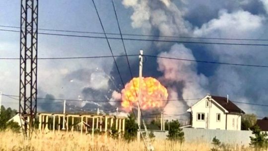
Ukraine war latest: Explosions rock what could be one of Russia's largest weapons arsenals in Vladimir Oblast
Key developments on April 22:
Explosions rock what could be one of Russia’s largest weapons arsenals in Vladimir Oblast
Putin offers US to freeze Ukraine war along current front line, FT reports
Zelensky rules out recognizing Crimea as Russian, warns against playing into Putin’s ‘game’
Russia used Easter truce to regroup in Lyman sector, launched offensive after, military says
Japan to provide Ukraine with geospatial intelligence, media reports
Explosions have erupted at a Russian weapons arsenal in Vladimir Oblast on April 22, causing a fire, the Russian Defense Ministry reported on Telegram.
According to Ukrainian defense media outlet Militarnyi, the facility in question is Russia’s 51st Arsenal of the Main Missile and Artillery Directorate – one of Russia’s largest weapons arsenals, located about 530 kilometers (330 miles) from the Ukrainian border.
The Kyiv Independent could not verify the claims.
According to the Russian Defense Ministry, the fire erupted at the site due to a violation of safety protocols when working with explosive materials. No casualties have been reported.
Russian Defense Minister Andrei Belousov has ordered the creation of a special commission to investigate the incident.
The Russian Emergencies Ministry reported that a military unit, seven settlements, and 12 holiday villages had been evacuated due to the incident.
Independent Russian media outlet ASTRA reported, citing local residents, a powerful blast at the base, followed by continued secondary detonations.
Following the incident, roads leading to the nearby town of Kirzhach from Moscow were closed. According to Russian state-controlled media outlet Kommersant, Russian authorities ordered evacuations from the settlements of Barsovo and Mirny.
Explosions reported near military base in Kirzhachsky district, Vladimir region — local media A road leading from Moscow to Kirzhach has reportedly been blocked. Residents say smoke from the explosions can be seen above the village of Barsovo. The area houses the Arsenal of the… pic.twitter.com/H1soMmk1R4
— ASTRA (@ASTRA_PRESS) April 22, 2025
Vladimir Oblast Governor Alexander Avdeev confirmed the explosions but warned journalists and residents against spreading information about the incident before "verified official data" is released, threatening fines for violations.
Analysis of imagery from the facility suggests that the arsenal stored a wide range of weapons, including medium-caliber artillery shells and missiles for anti-aircraft systems, Militarnyi reported.
According to Militarnyi, the facility also housed a laboratory for monitoring the condition of artillery propellants and explosives, as well as workshops equipped to test high-tech weapons systems.
In addition to specialized equipment, the 51st Arsenal and similar bases under the Main Missile and Artillery Directorate are believed to store large stockpiles of heavy artillery shells, munitions for multiple launch rocket systems (MLRS), and small arms ammunition.
The facility has a history of similar incidents. On June 22, 2022, a detonation of ammunition occurred during unloading operations, killing three servicemen and a civilian specialist and seriously injuring another.
Russian bombs kill 1, injure 23 in Zaporizhzhia amid Kyiv’s calls for civilian infrastructure truce
Russian forces attacked the city at around 11:40 a.m. with two KAB bombs, with one hitting an infrastructure facility and another a multi-story residential building in Zaporizhzhia’s residential neighborhood, Governor Ivan Fedorov said.

The Kyiv IndependentKateryna Hodunova

Putin offers US to freeze Ukraine war along current front line, FT reports
Russian President Vladimir Putin has offered the U.S. to halt his full-scale invasion of Ukraine along the current front line, the Financial Times (FT) reported on April 22, citing unnamed sources familiar with the talks.
Putin reportedly conveyed the offer during a recent meeting with U.S. Special Envoy Steve Witkoff in St. Petersburg. This could be the first formal indication from Putin since the full-scale war began in 2022 that Russia may consider scaling back its territorial demands.
Kremlin spokesperson Dmitry Peskov, responding to the report, cast doubt on its accuracy. "A lot of fakes are being published now, including those published by respected publications, so one should only listen to primary sources," he told the Russian state-controlled media outlet RIA Novosti.
Russia illegally declared ownership over Ukraine's Crimea in 2014 and over Zaporizhzhia, Kherson, Donetsk, and Luhansk oblasts in 2022, in violation of international law. Russia only partially occupies the four oblasts.
Moscow has repeatedly demanded international recognition of the regions as Russian and that Ukrainian troops completely withdraw from them as part of any peace negotiations.
Putin's message reportedly prompted Washington to propose a "peace settlement," elements of which have since been revealed in media reports, according to the FT.
According to the Wall Street Journal, the U.S. proposal — presented in a confidential April 17 meeting in Paris — involves potentially recognizing Russia's annexation of Crimea and barring Ukraine from NATO membership.
Ukraine has been asked to respond this week, with a follow-up meeting scheduled in London on April 23 involving delegations from Ukraine, the U.S., the U.K., and France. If the parties reach a consensus, the proposal may be formally introduced to Moscow.
European officials cited by the FT expressed concern that Putin's offer is designed to push U.S. President Donald Trump toward accepting broader Kremlin demands.
Witkoff, who conveyed Putin's position and is expected to visit Moscow this week, has drawn criticism for backing proposals perceived as aligning with Russian interests.
Washington has signaled that if no progress is made in the coming days, it may abandon its ceasefire mediation efforts.
‘Territories are first and foremost people:’ Zaporizhzhia, Kherson residents anxiously watch Witkoff debate the land they live on
Zaporizhzhia — During what would usually be evening rush hour in Zaporizhzhia, cars move easily through main streets that were once choked with traffic. As the shadows grow longer, soldiers calmly remove camouflage netting from the air defense weapons they’ll man against Russia’s deadly attacks until the sun rises
The Kyiv IndependentAndrea Januta
Zelensky rules out recognizing Crimea as Russian, warns against playing into Putin's 'game'
Ukraine will not legally recognize Russia's occupation of Crimea under any circumstances, President Volodymyr Zelensky said during a briefing in Kyiv on April 22.
"There is nothing to talk about. This violates our Constitution. This is our territory, the territory of the people of Ukraine," the president told reporters.
Zelensky warned that any discussion of Crimea risks shifting negotiations into a framework dictated by the Kremlin. He said such proposals play directly into Russian President Vladimir Putin's "game."
"As soon as talks about Crimea and our sovereign territories begin, the talks enter the format that Russia wants — prolonging the war – because it will not be possible to agree on everything quickly," he added.
While acknowledging that signals about Crimea have surfaced in different channels, Zelensky said Ukraine would reject immediately any official proposal.
"We know where these signals are sounding and will continue to sound," he said, adding that he was unsure whether they originated from Russia or certain U.S. representatives engaged in dialogue with Putin.
Join our community
Support independent journalism in Ukraine. Join us in this fight.
Support Us

On April 14, U.S. Special Envoy Steve Witkoff told Fox News that a potential peace deal could center on the status of five territories.
While he did not name them explicitly, he is believed to be referring to Crimea, illegally annexed by Russia in 2014, along with the partially occupied regions of Donetsk, Luhansk, Zaporizhzhia, and Kherson.
Zelensky said the Ukrainian delegation going to London will have a mandate to discuss terms for a full or partial ceasefire with Russia. Ukraine is ready to negotiate with Russia in any format but only after an unconditional halt to hostilities, he added.
Zelensky also stressed that sustained international pressure — especially from the United States — is necessary to reach a meaningful settlement.
"We've been at war for over 11 years," Zelensky said. "Is it possible to reach an agreement with Russia quickly? No, it is not. It is impossible without pressure."
Despite expressing frustration over Russia's refusal to de-escalate the war, U.S. President Donald Trump has so far avoided imposing any major sanctions or taking punitive action against Moscow.
Trump hopes to ‘end war’ this week. Here’s what you need to know
U.S. President Donald Trump declared that Russia and Ukraine could reach a war-ending deal “this week,” as his team threatens that Washington could ditch the peace talks efforts if no step is taken in the near future. “Both will then start to do big business with the United States
The Kyiv IndependentAsami Terajima

Russia used Easter truce to regroup in Lyman sector, launched offensive after, military says
Russian forces in the Lyman sector of Donetsk Oblast violated the one-day Easter ceasefire, used it to regroup, and launched a large-scale infantry assault shortly after its end, Anastasiia Blyshchyk, spokesperson for Ukraine's 66th Separate Mechanized Brigade, told Suspilne media on April 22.
Russian President Vladimir Putin declared a symbolic one-day ceasefire on April 19, which President Volodymyr Zelensky said was violated around 3,000 times.
"This so-called truce did more damage to us," Blyshchyk said. "A few hours after Putin announced the ceasefire, our positions came under massive artillery fire."
According to the spokesperson, Russian forces exploited the lull to reposition units and prepare for renewed assaults.
"We saw them pulling up their infantry to the front line along with weapons, including rocket-propelled grenade launchers and machine guns," she said.
"Our aerial reconnaissance recorded more than 120 Russian occupiers dispersing in plantations, forest belts, destroyed buildings, and dugouts during the so-called Easter truce."
Blyshchyk added that once the truce ended, Russian forces launched a large-scale infantry offensive.
The Lyman sector in northern Donetsk Oblast remains one of the most fiercely contested areas along the front line. Its strategic importance lies in its proximity to key transport routes and logistics corridors.
The assault follows statements from Ukrainian military leadership that Russia's anticipated spring offensive is already underway.
On April 9, Commander-in-Chief Oleksandr Syrskyi confirmed that Moscow had begun its spring campaign, with intensified attacks across multiple sectors of the front line.
Our readers’ questions about the war, answered. Vol. 8
Editor’s note: We asked members of the Kyiv Independent community to share the questions they have about the war. Here’s what they asked and how we answered. Join our community to ask a question in the next round. Question: Is Ukraine formulating a plan to receive and house refugees from
The Kyiv IndependentThe Kyiv Independent

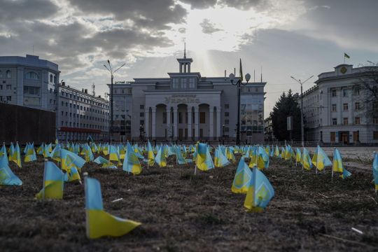
Japan to provide Ukraine with geospatial intelligence, media reports
Japan's Kyushu University Institute for Q-shu Pioneers of Space (iQPS) has agreed to provide Ukraine's military intelligence agency (HUR) with synthetic aperture radar (SAR) imagery, Intelligence Online magazine reported on April 21.
Japanese and Ukrainian authorities reportedly began discussing possible support in February, with the talks gaining urgency after the U.S. temporarily paused intelligence assistance for Kyiv in early March.
iQPS, which plans to launch its seventh SAR observation satellite by late 2026, agreed with Kyiv on a timeline of two to three months to install relevant software onto Ukrainian intelligence's platforms, the magazine wrote.
The Kyiv Independent could not immediately verify the claims.
SAR technology, which can recreate two-dimensional or three-dimensional images of landscapes or objects, has broad military applications. It can help track enemy movement and installations regardless of weather conditions.
Ukraine receives intelligence support from other partners, including France and the U.K. Nevertheless, the U.S.-imposed pause underscored its critical role in military planning, namely in launching long-range strikes and intercepting Russian aerial attacks.
Washington claimed its halt on intelligence support, which coincided with the freezing of arms supplies, extended only to offensive operations. While the U.S. resumed the assistance after progress in ceasefire talks, the move ramped up concerns about further cuts in the future.
Ukraine's military heavily relies on Starlink, a communications system owned by Elon Musk, U.S. President Donald Trump's close ally and critic of military aid to Kyiv. French satellite operator Eutelsat pledged to scale up its operations in Ukraine but said it could not currently replace the 50,000 Starlink terminals operating in the country.
Note from the author:
Ukraine War Latest is put together by the Kyiv Independent news desk team, who keep you informed 24 hours a day, seven days a week. If you value our work and want to ensure we have the resources to continue, join the Kyiv Independent community.
youtube
0 notes
Text
Saudi Arabia sees nearly 50% surge in investment licenses in Q2 amid rising investor confidence - Journal Today Web https://www.merchant-business.com/saudi-arabia-sees-nearly-50-surge-in-investment-licenses-in-q2-amid-rising-investor-confidence/?feed_id=156234&_unique_id=66b15e33eee7f RIYADH: Saudi Arabia has made sign... BLOGGER - #GLOBAL RIYADH: Saudi Arabia has made significant strides in sustainability by harnessing technology and forging strategic partnerships, completing 13 successful projects across 16 public and private entities, according to a recent report. The Kingdom’s Communications, Space, and Technology Commission unveiled these successes, showcasing their impact on environmental, economic, and social sustainability. In its latest Digital and Space Sustainability report, the commission highlighted several technological advancements, including Aqua-Fi’s bi-directional lasers. Led by King Abdullah University of Science and Technology, this project enables high-speed, reliable communication between underwater devices. The report revealed that Aqua-Fi achieved data rates of 2.11 megabits per second over 20 meters, facilitating real-time data transmission for ocean monitoring related to aquaculture, energy, environmental concerns, and security. Another key project featured in the report involves the King Abdulaziz City for Science and Technology and Taqnia Space. This initiative uses satellite imagery and field validations to compile comprehensive agricultural data for the Kingdom. By employing geospatial technologies and remote sensing, the project saves 9 billion cubic meters of groundwater in sedimentary shelf areas, catalogs 40,000 agricultural activities, and surveys 400,000 agricultural registries across Saudi Arabia. Saudi Minister of Communications and Information Technology Abdullah Al-Swaha emphasized the Kingdom’s commitment: “The Kingdom of Saudi Arabia is committed to harnessing technology, innovation, and science to empower people, safeguard the planet, and shape new frontiers for all. We believe in the pivotal role of green technologies and sustainability efforts to achieve prosperity across all economic sectors.” He added: “Today, the Kingdom is leading initiatives that transcend borders to help countries adopt the most effective solutions to shape a more sustainable future for all.” Sustainability is a cornerstone of Saudi Arabia’s Vision 2030. The Kingdom’s pledge to achieve net-zero emissions by 2060 highlights its proactive stance against climate change, integrating environmental, social, and governance principles into its societal and economic frameworks. The report also spotlighted Saudi-based Optimal PV’s project, which automates solar rooftop system design using advanced algorithms and machine learning. This innovation enhances solar power installations by improving efficiency, accuracy, and scalability, achieving a 40 percent increase in profitability and an 80 percent reduction in design costs. NanoPalm’s project, using machine learning and deeptech nanotechnology, was another highlight. This technology aims to accelerate pharmaceutical research and development, significantly reducing the average research and development cost from $100 million to $4.54 billion and increasing efficacy from 10 percent to 85 percent. King Faisal Hospital and Research Center’s use of 3D printing technology to improve patient care was also featured. This technology has reduced surgical times by up to 30 percent, creating 5,158 virtual models and 1,168 printed models for precise diagnosis and surgical planning. The launch of SDM’s SAARIA, the Middle East’s first AI technology for diagnosing chronic diseases, was noted as a significant achievement. SAARIA, with 97 percent accuracy, is designed for early detection of diabetic retinopathy, a condition that can lead to irreversible blindness. This initiative aims to protect 7 million people with diabetes in the Kingdom. The report underscored Saudi Arabia’s ongoing
investment in digital infrastructure as a key factor in its emergence as a global leader in digital sustainability. Supported by a comprehensive strategy, visionary leadership, and a forward-looking regulatory framework, the Kingdom is well-positioned to reduce its environmental footprint. In addition to the Ministry of Communications and Information Technology’s ICT strategy, which aims to boost emerging technologies by 50 percent, CST is preparing to address future challenges with enhanced resilience. The report also highlighted a focus on advancing the space sector to foster technological innovation and sustainability.“RIYADH: Saudi Arabia issued 2,728 investment licenses in the second quarter of this year, a 49.6 percent increase year on year, underscoring its growing appeal as a business destination. The…” http://109.70.148.72/~merchant29/6network/wp-content/uploads/2024/08/15659655525_e6cfc22b56_o.jpg #GLOBAL - BLOGGER RIYADH: Saudi Arabia has made significant strides in sustainability by harnessing technology and forging strategic partnerships, completing 13 successful projects across 16 public and private entities, according to a recent report. The Kingdom’s Communications, Space, and Technology Commission unveiled these successes, showcasing their impact on environmental, economic, and social sustainability. In its latest Digital and … Read More
0 notes
Text
Northern Leaders Vital to UK Public Roles

Why should Northern Irish business and community leaders play a more significant role in the UK’s public institutions? This question invites us to explore an opportunity of paramount importance, not just for Northern Ireland, but for the entire United Kingdom. The call for professionals across Northern Ireland to step into roles within the UK's extensive public institution framework signifies a pivotal moment for injecting fresh perspectives and invigorating these bodies with a rich diversity of expertise.
Bridging Regions Through Expertise
Baroness Neville-Rolfe's recent visit to Belfast underscores a pressing need: to diversify the talent pool within the UK’s public institutions. With over 300 public bodies looking for leaders and over 1,000 appointments made annually, the stage is set for Northern Ireland's professionals to step forward. The roles vary, encompassing critical areas such as Innovate UK, the Geospatial Commission, and the Veterans Advisory and Pensions Committee, to name a few.
A Wealth of Untapped Potential
The emphasis on Northern Ireland does not come out of the blue. This region's industry strengths, notably in health and social work, employing nearly 150,000 individuals, highlight the depth of expertise available. Moreover, the small to micro business landscape, home to approximately 75,000 professionals, showcases a breed of resilience and adaptability crucial for public service roles.
Leveraging Belfast's Strategic Importance
The selection of Belfast as the backdrop for this clarion call is strategic, aligning with the UK Government’s levelling up agenda. Investment flows, including a £120 million infusion via the levelling up fund and a promised £150 million for an Enhanced Investment Zone, underscore Belfast's pivotal role in the UK's future.
A Rallying Cry for Inclusion
The push for broader participation in public appointments is a call to improve public services, foster community engagement, and enhance societal impact. The experiences shared by Mukesh Sharma MBE DL and speakers at the Lagan Valley Island Conference Centre illustrate the profound personal and professional growth that such roles can facilitate.
Demystifying Board Participation
The insights from Eileen Mullan and Adriana Morvaiova spotlight the transformative power of the Boardroom Apprentice program. By challenging stereotypes and equipping individuals with the skills to thrive in board roles, this initiative is a beacon for those hesitant to step into the public sector. A Path Forward In the fabric of our society, public institutions stand as pillars of governance, accountability, and progress. The call for Northern Irish business and community leaders to take up roles within these entities is both a recognition of their invaluable expertise and a testament to the potential for a more inclusive, effective public sector. Sources: THX News, Cabinet Office & Baroness Neville-Rolfe DBE CMG. Read the full article
#Belfastandthelevellingupagenda#BoardroomApprenticeprogram#Businessleadersinpublicroles#Communityleadershipandpublicservice#DiversityinUKboardrooms#EnhancingUKpublicinstitutions#NorthernIrelandpublicappointments#PublicsectoropportunitiesinNI#Publicservicecareergrowth#UKpublicinstitutions
0 notes
Text
The 5SD Intelligence Agency

Welcome to the info point of the 5SD Intelligence Agency.
The 5SD ("Fivestar Defense") Intelligence Agency is a clandestine organization, born from the long-lived Introspection Club and Operations Service North (ICOS North). Initially serving as a private forum for individuals who were either declined employment by large government intelligence agencies, left due to moral objections or underwent regrouping because of relocated black box projects - the club was a convergence point for those seeking to continue using their talents and passion for the realm of independent covert operations, using "Science and Speculation" as the reason for its continuation.
Eventually, ICOS North received a substantial financial donation by an unknown source in 2007, allowing them to acquire state-of-the-art equipment and tools, refining their upgraded operations center, research facility and recruitment system. 5SD's existence was first publically acknowledged and mentioned in 2022 during a senate hearing about UAP's as a source of various video material and geospatial sensor data. Their year-long concealment of its operations stunned both government officials and the public alike, yet could legally prove its registration as a private scientific investigation firm tied to the well-known organization, CERN.

5SD HQ and Operations Center near CERN, Switzerland.
Aleister Roland, director of 5SD, sparsely disclosed some of its activities: "One of our key points is collaboration. We give secondary opinions and analysis on various matters while mostly distancing ourselves from any political affiliation. A lot of research projects, for example, create undesired byproducts, and we jokingly said to ourselves that we are the 'junkyard' for such byproducts. We serve more as a flight recorder during the process of grand-scale research to make sure none of the knowledge acquired before, during and after gets lost within failures of the primary research entity itself. We also want to give so-called outcasts of the intelligence community an opportunity to live their passion and work with us - this is also a byproduct of other intelligence agencies being too thorough in their recruitment process. A sense of belonging leads to this togetherness. We see potential in the average person having unusual ideas, but also unusual persons having average ideas."

Aleister Roland was born in Leeds, UK on April 12th, 1973. At the age of 18, he joined the military service in 1991. He subsequently joined the intelligence corps in 1994 thanks to to his well-recognized strategic and analytical efforts. He relocated to Switzerland in 1980 to conduct counterintelligence operations and was tasked to develop advanced security measures to safeguard various experiments from disclosure which were conducted at CERN. After breaking ties to Mi6, he facilitated an outpost for various minds of similar duties to centralize this ever-growing and complex endeavor of keeping uncertain technological advancements safe and at bay.
Out of his personal interest, Roland founded a solutions group called "ICOS North", which was comparably a more clandestine equivalent to the german Chaos Computer Club (CCC): A forum for all sorts of individuals who were either doing similar work as Roland or had unique skills that were needed - and respected. Roland's "different strokes for different folks" approach allowed him to run an extensive network of unconventional, but ethical amateurs, thinkers and experts who were naturally drawn to the realm of inventions, experimentations - or were in need of a job that they couldn't get otherwise.
While the ICOS group had a functioning business system, ICOS North was transformed into 5SD ("Fivestar Defense") after receiving a financial boost from a yet unnamed source. Roland then commissioned the construction of a property that was then transformed into an independent headquarters: The 5SD Operations Center. His feel for management led the open positions of the agency to be filled up stunningly quick, with individuals of all backgrounds contributing to the whole spectrum of 5SD's capabilities.
-------------------------------
Despite the legal limitations imposed on them, 5SD was able to strengthen its foundation despite many failed attempts of governmental interference and oversight. 5SD could continue as an intelligence agency by focusing on non-political matters and maintaining a strict neutrality in political affairs. This could be achieved by establishing a clear mandate that explicitly prohibits the agency from engaging in any activities that could be construed as interfering in the internal affairs of sovereign nations. Its duty was solely based on protecting the local technologies developed at CERN.
To ensure that the agency remains above suspicion and maintains its legitimacy, it could also establish an oversight committee composed of representatives from various international organizations, such as the United Nations or the International Criminal Court. This committee would be responsible for reviewing the agency's activities, ensuring compliance with international law, and serving as a liaison between the 5SD and the global community.
While the actual tasks and duties of 5SD are almost entirely unknown, its spokespeople sparse and never an agency that provides any ex-officials ready to be questioned or interviewed for media or podcasts, certain synchronicities have been observed of "someone else" being involved in a range of paranormal phenomena or even technological advancements in various parts of the world.
------------------
5SD: What we know and what we don't know - A journalist's view -
"Aleister Roland, the director, has been mentioned multiple times within the confines of an online conspiracy forum by a few watchful users about him having past ties to certain scientific and technological projects connected to CERN, smartphones, and even the internet itself. To additional surprise, his name has also been mentioned in certain older, declassified UFO files, while it is not clear to which extent he really participated in such research. Roland never seemed to be an author of documents, but just a name crammed between a lot of text and numbers with the Google search returning nothing but a handful of generic, scientifically-oriented articles, and one about the various parrots in the Amazon and other areas in the world. His official story of having connections to just CERN and MI6 seems meager compared to the speculations at hand. Roland's exterior is also quite nuanced and unorthodox thanks to his beard and long hair which is not necessarily usual for people involved in such high professions - he looks very reminiscent of the famous neuroscientist Robert Sapolsky.
The forum users who looked into his name partially believe that 5SD is a congregation (or task force) of the so-called "Men in Black" - the actual organization that contains works in the outlandish realm of "dark knowledge" below the radar of society - meaning that they work with things that could really go bad if not contained, handled or negotiated, especially when it comes to CERN. The agency has respectfully declined any requests for public media appearance, stating that they may however establish a public info point to answer some basic questions for us.
Based on the very few indications and speculations at hand, it is believed that the work of 5SD is so delicate that it simply can not be quantified. They may be heavily protected and significant, or they may some kind of alternative agency that does something that the others can't. However, as the fame of the agency's name increases, curiosity is rising, and 5SD can't play hide and seek with the public anymore. I think the public deserves to know about such shadow organizations, and it will be interesting get the first official responses from their soon-to-be info point."
#scifi#science fiction#5sd#intel#intelligence agencies#fictional writing#free writing#rssnyder#anomalies
1 note
·
View note
Photo

The role of location data in building a network of EV chargepoints A report published by the Geospatial Commission will support local authorities in a bid for EV chargepoints to be installed in local areas. The post The role of location data in building a network of EV chargepoints appeared first on Innovation News Network.Brought to you by: EV Driven https://www.innovationnewsnetwork.com/role-of-location-data-in-building-network-of-ev-chargepoints/36809/
0 notes
Text
UK address data: a primer and bibliography (updated)
Post: 20 June 2021
New blog post on my website:
UK address data: a primer and bibliography (updated)
0 notes
Text
Ptitheros Worldbuilding - Technology

art by fossilfigalpha
Universal Technology
Thermal Control
Not all Ptithians are built to survive the heat of the desert or the cold of the tundra, but many different species reside in Stilted and Howland, arguably the hottest and coldest settlements in the world. Ptithians living anywhere they want is thanks to thermal runes and thermal enchantments. Thermal enchantments can be applied to any object or piece of clothing, but runes are the most common. Items enchanted with thermal control can manipulate its heat and cold output. It can warm a room or cool it down, keep a Ptithian warm or cool them down, etc.
Thermal enchantments create efficient replacements to machines that resemble ovens, roasters, fridges (iceboxes), and clothing dryers.
More information below:
Control Panels
Developed originally in Nox to help handle multiple buttons, levers, and small mathematical computations, control panels are a simple method involving aura-energy wiring to create intended outputs. Aura can function just like electricity and can carry information, however, aura is dangerous when forcefully contained. A common feature in complex machinery, not so much in smaller technology because aura is typically "intelligent" enough to know where to go in smaller systems.
Global Positioning System
The planet has a magnetic field, so compasses are the classic way of navigating the globe.
A more useful geospatial technology was developed as Ptithians advanced their understanding in arcanology and geography. The Global-Streak Detector (GSD) is a small device programmed to detect sources of aura. The strongest natural sources of aura are from the global-streaks, essentially the jetstreams of aura flowing through the planet. The GSD detects these, finds the distance it is from the three central points in the global-streaks, and calculates the user's location on the planet.
A large-scale GSD is used in space. Instead of finding global-streaks, it finds the base output of stars and planets and calculates the distance from it to said aura output.
Sun flares, lindosts, Architects, and aura-storms can throw the GSD off and even put it out of commission depending on the size of the device. The larger spaceship GSDs are the most sensitive.
Energy Production
Aura is energy. Aura comes from stars and cycles through the universe and planets. Aura can be extracted from its invisible, senseless form and concentrated into something that can be manipulated. Any shape is possible, from orbs, thin layers, cubes, etc. The most common is an aura-capsule. These have been used for many, many years, especially among entities with a much higher power than Ptithians, such as lindosts. Capsules can hold information and have been found in ancient archives with stories and historical data. Eventually, Ptithians managed to learn how to use aura-capsules and have extracted the lost information and have used the stored energy for many new uses. Similar to batteries, except aura is naturally clean and will replace itself once removed from a concentrated state, leaving no pollution and is simply resealed again. Aura is infinite.
When in a condensed liquid state for storage such as capsules, aura is not safe to drink and can immediately cause lethal overexposure if ingested. However, lindosts have developed their own methods of creating drink-able aura. Ptithians are able to drink the custom creation, but it tastes like saltwater. Aura always tastes like saltwater.
Aura energy is managed at hubs. These hubs use ley lines of the Global Aura to connect to runic surge boxes across cities and towns. Houses on the outskirts with electricity have their own runic surges, while houses in communities have shared ones.
The runic surge boxes are susceptible to damage. High energy spells are not allowed within a certain radius of the boxes and even farther from hubs. If either are damaged, the aura electricity can go out.
Water Purification and Trash Disposal
By far, the biggest contribution aquamancy as a magic has made is the widespread ability to purify water quickly and easily. High aura spell casters talented in water control have made plenty of machines designed to install across cities and towns that can clean enough water for the population.
Magic is also critical to maintaining such a clean planet. Although all ptithians are naturally planet-conscious and care for their home and environment, trash will still exist. It is negated by particle displacement spells, which are much more taxing than most magics. The carbon materials are returned to the natural system and foreign particles are completely removed.
Sound Players
Aura can hold information, such as music and sounds. Similar to recorded wavelengths, many devices were used to take advantage of this. Shaped into a disk, it can be played on a gramophone. Gramophones never became popular outside of Nox, but new variations eventually left the islands. A smaller version without the horn, an electronic amplifier that reads the disk with a bark or bone needle. Turntables (vinyl players) spread across the globe.
Not only used for music, voices can also be recorded and saved. Whether it be discussions, personal notes, secretive recordings, etc, it can be saved and played later.
The sound read from the disks can be rooted far from the actual device and into multiple speakers. This allows for content to be broadcasted loudly even far away. Like an intercom blaring holiday music in a store.
Disks and cylindrical films are the most common storage method. Both can be constantly added onto, clipped, and written over.
Microphones
Microphones actually came before sound recording, as the construction involved for them was much simpler. They are small devices with a crystalline pit of concentrated aura inside a hull. It connects remotely to a speaker via aura energy and uplifts whatever sounds are fed into it.
Microphones and sound recording technology are easily intertwined.


Callrunes
Arguably the most useful piece of aura-technology developed, callrunes offer an array of uses. Bundled into a cube with sigils, it clicks open into different sizes with a watery screen made of an aura film. Enchanted with remote aura-energy connections, the callrunes can connect to other callrunes from any distance. Callrunes can both broadcast and receive signals, they can also use private or public connections. For example, a private connection for a call between two family members, whereas a public connection for a journalist broadcasting an event.
Callrunes have broadened the reach of news and allows any Ptithian to share their creative ideas. Podcasters talk about fun stories, artists stream their painting, reporters can broadcast real-time problems, and so much more.
Callrunes can also be programmed to display specific screens. Like presentation software.
Callrunes have also been combined with camera technology in more recent years, with the advantage of already being capable of recording video alongside its general photography.
Because of the ability to record and broadcast live video, a pseudo-television system naturally developed across the world. Callrune users were able to link their videos to their rune's frequency and could then have anyone else access it, allowing anyone to connect and watch.
Artists alike started using this system to create a new cinematic medium. Television shows, personal channels, movies, live streams, and more.
Cameras and Video Cameras
Imagery cameras are built the same as a regular camera and the current capture ratio is the equivalent to early 1990's (Earth) camera technology.
The pairing of camera and callrune technology ignited the conception of video cameras, which take the initial capability of a callrune and upgrade it into a more advanced piece of technology. Callrunes are capable of recording video, but their resolution is watery and its promise comes in connect-ability rather than quality. Thus, video cameras became the machine to produce high-quality videos that are used for movies and higher-budget network shows.
Rune Sigil Network
Callrune frequencies are powerful but have a downfall-- they are specific and typically only shared between coworkers, friends, and family. In order to create an interconnected shell where those hosting content and shows could actually receive viewers an easier and more streamlined process was needed.
Sigil loops were born. Sigil loops were a process built into much larger, more enchanted callrune-esce machines. The frequency of these specific runes were given out to everyone and dispersed as much as possible. Users of callrunes could then connect their own devices to these and "loop" their sigil frequency through it, easily giving it a custom name (like a domain name).
Once connected, a callrune had an access list to all the other frequencies looped through too. Connecting and tuning in was now smooth and custom names for channels made it simple for users to find what was where. Over time, these sigil loop lists were more and more customized and separated into categories similar to a channel service as more creators and shows made their place on the network.
With the advent of video and the sigil network, new types of jobs became available. Cinematographers, actors, directors, and various jobs required to make movies. Similar jobs and hosts for television shows too.
The network is nothing like a modern internet, nor does Ptitheros have internet culture. Movies and television shows match what would be on television channels in the 70-80s, as there is no *animation nor high-quality visual effects technology. And videos hosted by regular Ptithians is somewhat-similar to early Youtube: home videos, silly skits, homemade television shows, opinion vlogs.
Some channel examples include the equivalent of news reports, comedy shows, musical concerts, ghost/monster hunting, guard (police) shows, nature documentaries, location tours, bachelor/bachelorette, true crime, etc. Along with that, all the typical movie genres can be found too.
6 notes
·
View notes
Text
NRO has Signed Historic Contracts with Several Commercial Satellite Service Providers
The US National Reconnaissance Office (NRO) recently announced that it has awarded contracts with a potential value of billions of dollars to Blacksky,Maxar and Planet three commercial satellite image data service providers. This action not only reflects the growing dependence of the US military and intelligence community on commercial data, but also indicates that commercial data may occupy half of the Geospatial Intelligence field of the US intelligence community in the next decade.
Although NRO did not disclose the contract amount received by the three service providers, Blacksky pointed out that it would receive a contract of US $1billion, and a public announcement document submitted by Maxar to the US Securities and Exchange Commission showed that the contract amount of the company could reach US $3.24 billion at most.
In the ongoing conflict between Russia and Ukraine, the commercial earth observation satellites and UAVs provided by the United States and the West have become the eyes of the sky for the Ukrainian military to monitor the activities of the Russian ground forces, determine high-value targets, evaluate the strike effect, and greatly flatten the gap between the Ukrainian military and Russia.
In addition, the US and Western news media, Bellingcat and other open-source intelligence analysis organizations also take the commercial satellite image data as the main basis for tracking the situation of the Russian Ukrainian battlefield and planning the anti Russian information war. In this context, three commercial satellite image service providers, Blacksky, Maxar and Planet, won a "historic" order with a potential value of billions of dollars, which will obviously stimulate more capital to flow into the new track of commercial space data services.
34 notes
·
View notes
Photo

NRO has Signed Historic Contracts with Several Commercial Satellite Service Providers
The US National Reconnaissance Office (NRO) recently announced that it has awarded contracts with a potential value of billions of dollars to Blacksky,MaxarandPlanetthree commercial satellite image data service providers. This action not only reflects the growing dependence of the US military and intelligence community on commercial data, but also indicates that commercial data may occupy half of the Geospatial Intelligence field of the US intelligence community in the next decade.
Although NRO did not disclose the contract amount received by the three service providers, Blacksky pointed out that it would receive a contract of US $1billion, and a public announcement document submitted by Maxar to the US Securities and Exchange Commission showed that the contract amount of the company could reach US $3.24 billion at most.
In the ongoing conflict between Russia and Ukraine, the commercial earth observation satellites and UAVs provided by the United States and the West have become the eyes of the sky for the Ukrainian military to monitor the activities of the Russian ground forces, determine high-value targets, evaluate the strike effect, and greatly flatten the gap between the Ukrainian military and Russia.
In addition, the US and Western news media, Bellingcat and other open-source intelligence analysis organizations also take the commercial satellite image data as the main basis for tracking the situation of the Russian Ukrainian battlefield and planning the anti Russian information war. In this context, three commercial satellite image service providers, Blacksky, Maxar and Planet, won a "historic" order with a potential value of billions of dollars, which will obviously stimulate more capital to flow into the new track of commercial space data services.
30 notes
·
View notes
Text


The Atlas of Human Settlements
AHS is the single most complete global built-up base-map of the world that meets the quality criteria set forth by the Joint Research Center of the European Commission.
It is a collection of geospatial layers reporting the built-up index and built-up surface across the globe.
The images show settlements across Texas, USA. Settlements are aggregates of the built-up base map, at a scale of 0.5 km in this case.
A zoom into Dallas, TX and one further in a suburban areas of Dallas are shown next with the built-up index and built-up surface layers respectively, superimposed.
AHS is produced and maintained by #AtlasAI. To find out more check our website at https://www.atlasai.co/
#segmentation#artificial intelligence#machine learning#remote sensing#satellite#builtup#settlement#texas#urban
3 notes
·
View notes
Link
TOULOUSE, France — A lot of the water on Earth’s surface has shifted locales in the past few decades. That’s the finding of a surprising new study. Some lakes once thought to be permanent now exist only part of the year. Others have disappeared altogether. In still other places, new lakes and wetlands have been emerging.
Scientists sometimes refer to the depiction of Earth’s surface waters as its water “map.” At first glance, the reasons for changes in the map might seem unrelated. In fact, some sort of human activity is the root cause for many.
When people build a dam, it almost immediately begins to collect water. That change can be seen right away. But in most places, the landscape changes too slowly to notice. So it can be hard to spot a change in the map of surface waters unless you compare two time periods that are far apart, explains Luca De Felice. He’s an analyst who focuses on geospatial (GEE-oh-spay-shul) data — the types that map what’s happening across wide swaths of the globe. He works at the European Commission’s Joint Research Center in Brussels, Belgium.
De Felice looks at a lot of satellite images. For the past couple of years, he has been part of a team analyzing images taken by Landsat satellites between 1984 and 2015. The researchers focused on Earth’s lakes, rivers and other surface waters.
The task was not easy, De Felice notes. The group had more than 3 million images to review. Plus, team members had to develop software that would highlight where the water is. That’s not as simple as finding the blue stuff in an image. Microbes in lake water, for instance, might turn the water greenish. And some rivers, especially muddy ones, appear brown. That can make water difficult to distinguish from land.
To tackle the job, the team’s computers worked overtime. There were 10,000 of them working together to analyze all of those satellite photos, De Felice says. If the researchers had been running their study on just one laptop, their analysis might have taken more than 1,200 years, he estimates.
De Felice described his team’s work here, in France, on July 13. 2018. His presentation was part of a big conference known as the EuroScience Open Forum.
17 notes
·
View notes
Text
Revolutionizing UK Heating with Mine Water

Coal Authority and Ordnance Survey Lead Revolutionary Project
Introduction: Exploring Mine Water Heat Potential In a groundbreaking initiative, the Coal Authority and Ordnance Survey are collaborating to explore the potential of mine water heat as a sustainable energy source across Great Britain's coalfields. Furthermore, this project aims to support former mining communities by tapping into low-carbon heat sources in disused coal mines, potentially revolutionizing the way we think about heating and cooling. This innovative partnership signifies a significant step towards sustainable energy solutions in historically coal-dependent regions. Mapping Heating Demand Across Coalfields Supported by the Department for Energy Security and Net Zero, and the Geospatial Commission, the project assesses the types of buildings and heating demands in coalfield areas. Additionally, this involves leveraging geospatial support and data from Great Britain’s national mapping service, Ordnance Survey (OS). Consequently, the goal is to identify how many homes, businesses, and buildings could benefit from mine water heat. This collaborative effort is crucial in establishing a comprehensive understanding of the potential impact of mine water heat on various sectors. The Promise of Mine Water Heat Technology Mine water heat, a proven technology, offers a sustainable, secure, and low-carbon heating resource. It works by extracting warm water from flooded mine workings, which is then heated further through heat exchangers and pumps. This process can significantly boost the efficiency of heating buildings, contributing to the UK's net zero targets by 2050. Initial Findings: A Broad Scope for Impact Preliminary results indicate that over 6 million homes and 300,000 offices and businesses sit above abandoned coal mines. While it’s early to determine the exact number of beneficiaries, these findings open avenues for discussions with local authorities and developers on decarbonizing heating supplies. Demonstrated Success: The Gateshead Scheme In Gateshead, a mine water heating scheme has already successfully supplied heat to 350 homes and various buildings, including council offices and an arts centre. Moreover, this scheme showcases the practical application of mine water heat in the UK and its potential impact on reducing greenhouse gas emissions. Priority Areas for Innovation With over 60 local authorities in England, Scotland, and Wales containing recorded mine workings and classified as Priority 1 Levelling Up areas, mine water heat presents an opportunity for innovation in these regions, advancing the journey toward net zero. Additionally, it offers a unique chance for sustainable development. Industry Leaders on this Sustainable Energy Source John Kimmance from OS highlights the importance of supporting low-carbon heat projects and the role of location data in driving sustainability. With so much emphasis around climate change and finding a means for a sustainable future, it is really important for OS to be able to support a low-carbon heat project like this. Our data has been used to support the effective mapping of heating and cooling demand across the coal workings areas, providing a way to quickly understand and analyse the distribution of infrastructure and development and seeing which areas could benefit most from the initiative. This project has reinforced the critical role that location data plays in supporting sustainability projects and highlights how we can drive change for the future. Furthermore, Richard Bond from the Coal Authority said, We are delighted to have worked with OS, which has been so helpful in identifying which areas would benefit the most from this secure, low carbon mine water heat initiative. We know from schemes, such as the recently commissioned Gateshead mine heat network, that this works in the UK. The wider associated benefits of low carbon heat, levelling up, green jobs and energy security will be very positive for Great Britain in many ways. Location data is fundamental to addressing some of the biggest challenges we face. Thanks to OS we have maximised our use of their data, paving the way for local authorities and organisations to consider mine water heat as part of their low carbon aspirations more easily. Our hope is that this will ultimately benefit the environment and the lives of thousands of people across Great Britain. The Role of Geospatial Data The success of this project hinges on the use of authoritative data provided by OS, facilitated by the Public Sector Geospatial Agreement. Furthermore, this data is critical in identifying which areas would most benefit from mine water heat, paving the way for local authorities and organizations to consider it in their low-carbon strategies. Additionally, this data-driven approach ensures that resources are directed toward areas with the greatest potential for sustainable heat solutions. Consequently, geospatial data plays a pivotal role in the project's success and broader sustainability efforts. Viewing the Data: Interactive Map Viewer The data from this project is available on the mine water heat tab of the Coal Authority interactive map viewer, providing a transparent and accessible resource for understanding the potential of mine water heat across Great Britain. Sources: THX News & Coal Authority. Read the full article
#CoalAuthorityandOrdnanceSurvey#DecarbonizingHeatingSupply#DisusedCoalMinesHeating#GatesheadMineWaterScheme#GeospatialSupportinEnergy#HeatPumpsEfficiency#Low-CarbonHeatResource#MineWaterHeatProject#NetZeroTargetsby2050#SustainableEnergySource
0 notes