#MappingSolution
Explore tagged Tumblr posts
Visit Tumblr Blog
Explore Tumblr blogs with no restrictions, modern design and the best experience.
Last Seen Tumblr Blogs


Fun Fact
Mobile US users spent an average of 115.8 minutes on Tumblr app monthly.
Text
youtube
Konversi SHP ke UTM di QGIS 3? Ikuti Trik Simpel Ini!
Jangan sampai data GIS kamu berantakan karena salah konversi! Yuk, pelajari teknik mudah dan akurat untuk mengubah SHP Geographic ke UTM dalam hitungan menit.
#GIS#QGIS#QGIS3#KonversiKoordinat#PetaDigital#SHPtoUTM#ProyeksiPeta#UTM#GeographicToUTM#SistemKoordinat#TutorialGIS#PanduanQGIS#BelajarGIS#Geospasial#DataSpasial#AnalisisGIS#AkurasiPeta#TransformasiKoordinat#PemrosesanData#GISMapping#ConvertSHPtoUTM#GISIndonesia#GeospatialTech#MappingSolution#DataGeospasial#Youtube
0 notes
Text
Explore how utility mapping supports large-scale infrastructure development across the USA. Learn how advanced mapping technologies help detect underground utilities, reduce project delays, prevent costly damages, and enhance public safety. Ideal for engineers, contractors, and city planners aiming for smarter project execution.
#utility mapping#InfrastructureUSA#CivilEngineering#ConstructionTechnology#PublicSafety#UndergroundUtilities#MappingSolutions
0 notes
Text
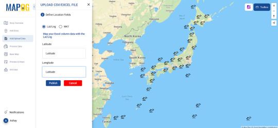
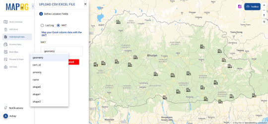
How to Geocode Excel Data into a Map?
Introduction
Turning raw Excel data into a visual map can be a game-changer for businesses, researchers, and urban planners. Whether you need to analyze sales territories, track deliveries, or study demographic trends, mapping your data helps unlock insights that spreadsheets alone can't offer. This article will walk you through the process of geocoding Excel data and transforming it into an interactive map.

What is Geocoding?
Geocoding is the process of converting addresses or place names into geographic coordinates (latitude and longitude). Once geocoded, this data can be visualized on a map for better spatial analysis.
Steps to Geocode Excel Data
1. Prepare Your Data
Before uploading your Excel file, ensure it contains:
Address fields (Street, City, State, ZIP Code, Country) OR latitude & longitude columns.
A clear and consistent format without duplicate entries.
2. Use an Online Geocoding Tool
Several platforms offer geocoding services where you can upload Excel files and generate maps. Pick one such tool allows users to geocode their data seamlessly like MAPOG, making mapping a hassle-free experience.
3. Upload and Process Your File
Import your Excel file (.csv or .xls format).
Map the appropriate columns to ensure accuracy.
Run the geocoding process, which assigns latitude and longitude to each entry.
4. Visualize Your Data on a Map
Once geocoded, your data points will appear on an interactive map. You can customize it by:
Changing basemaps (road, satellite, hybrid views).
Applying color-coded categories for better analysis.
Adding additional attributes like time zones, demographics, or custom fields.
Real-World Applications of Geocoded Maps
Business & Sales Tracking
Companies can map customer locations to optimize delivery routes.
Sales teams can analyze which regions have the highest conversions.
Urban & Environmental Planning
City planners can study population density and infrastructure needs.
Environmentalists can track pollution sources and their impact zones.
Healthcare & Public Services
Hospitals can map patient distributions to allocate resources efficiently.
Emergency responders can analyze risk-prone areas for better preparedness.
Tools to Explore
Platforms like MAPOG provide useful tools for geocoding and mapping. The Upload CSV-Excel tool is specifically designed to help users transform spreadsheet data into actionable maps while supporting formats like CSV, XLSX, XLS, ODS . If you're looking for a user-friendly, powerful way to visualize data where you can upload both latitude, longitude and WKT data, it's worth exploring.
Conclusion
Geocoding Excel data into a map can simplify complex datasets, reveal patterns, and enhance decision-making. Whether you're in business, urban planning, or research, mapping your data brings it to life.
Ready to get started? Try out mapping tools and see how geocoding can elevate your workflow!
0 notes
Text
Revolutionizing Data Collection with Drone Survey and Mapping Technology

In today's fast-paced world, data collection is a crucial part of decision-making across various industries. Whether it's for construction, agriculture, or environmental monitoring, gathering accurate data is essential. This is where drone survey and mapping technology comes into play, revolutionizing how data is collected and analyzed.
What is Drone Survey and Mapping Technology?
Drone survey and mapping technology involves using drones equipped with advanced sensors and cameras to gather aerial data. These drones fly over specific areas, capturing high-resolution images and data. The collected information is then processed to create maps, 3D models, and other useful data visualizations. This technology is transforming industries by offering a faster, more cost-effective, and precise method for data collection.
Applications of Drone Survey and Mapping
Construction: Drones are incredibly useful in construction projects, where they provide detailed site surveys, monitor progress, and help in planning. They can capture real-time data, ensuring that projects stay on track and on budget.
Agriculture: In agriculture, drones are used to monitor crop health, identify problem areas in fields, and create prescription maps for precision farming. This enables farmers to optimize resources and increase crop yields.
Environmental Monitoring: Drones equipped with specialized sensors help monitor forests, coastal areas, and other ecosystems. They can detect environmental changes, track wildlife, and assess natural disasters like floods or wildfires.
Mining and Energy: Drones are essential for mapping large mining sites, monitoring resource extraction, and conducting inspections in hard-to-reach areas. They help in managing resources more efficiently and safely.
Why Drone Surveying is a Game-Changer
Speed: Drones can cover large areas quickly, which is a huge advantage compared to traditional methods that may take days or weeks.
Cost-Effective: Using drones for surveying eliminates the need for expensive equipment and reduces labor costs. It's an affordable option for industries that need frequent data collection.
Accuracy: Drones provide high-resolution imagery and precise measurements, ensuring that the collected data is accurate and reliable.
Safety: Drones reduce the need for human workers to go into dangerous or hard-to-reach areas, improving safety on the job site.
The Power of 3D Modeling and Mapping
One of the most exciting features of drone mapping technology is the ability to create detailed 3D models of the surveyed area. These models give a comprehensive view of the landscape and help in planning and decision-making. For example, in construction, 3D models can assist engineers in visualizing how a building will fit into its environment before any physical work begins.
Key Technologies Behind Drone Surveying
LiDAR (Light Detection and Ranging): LiDAR technology is used to measure distances by bouncing light pulses off objects. It’s ideal for creating precise topographic maps and 3D models, even in areas with dense vegetation.
Photogrammetry: This technology involves using photographs taken from drones to create detailed maps and 3D models. It’s especially useful for high-resolution imagery and land surveys.
Real-Time Data Analysis: With advancements in technology, drones now have the ability to transmit data in real-time, allowing businesses to make quick decisions and adjust strategies immediately.
The Future of Drone Survey and Mapping
As drone technology continues to advance, its potential in data collection and mapping will only increase. We can expect even more accurate and efficient tools, with the ability to create even more detailed maps, analyze environmental data in real-time, and offer solutions that were once unimaginable.
Industries across the world are already benefiting from drone survey and mapping technology, and the future looks incredibly promising. Whether it's improving construction project timelines, helping farmers optimize their crops, or monitoring the environment, drones are changing the way we approach data collection.
Conclusion Drone survey and mapping technology is revolutionizing how we collect, process, and analyze data. It’s faster, more accurate, and more cost-effective than traditional methods. As the technology continues to evolve, we can expect even more industries to benefit from its capabilities. Whether you're in construction, agriculture, or environmental science, drones are changing the game for data collection.
#DroneSurveyAndMapping#UAVSurveying#AerialMapping#DroneMapping#SurveyingTechnology#MappingSolutions#DronesForSurveying#AerialSurvey#LiDARMapping#RemoteSensing
1 note
·
View note
Text
📍 Transform your data into powerful maps and insights with our GIS Software Development Services! 🌐 Customized. Scalable. Intelligent. #GIS #SoftwareDevelopment #MappingSolutions
1 note
·
View note
Text

Unlocking Business Potential with Geospatial Insights
Discover how geospatial data is transforming decision-making by identifying key points of interest (POIs) across industries. From retail expansion and urban planning to tourism and environmental monitoring, businesses can leverage geospatial insights for strategic growth and operational efficiency. With Advintek Geoscience, unlock precision-driven analytics to optimize locations, enhance services, and stay ahead of the competition.
READ MORE: https://geosciences.advintek.com.sg/identifying-key.../
#GeospatialData#LocationIntelligence#DataAnalytics#UrbanPlanning#RetailExpansion#TourismTech#EnvironmentalMonitoring#POIAnalysis#BusinessGrowth#SmartCities#MappingSolutions#TechForGood#GISMapping#SpatialAnalysis#Innovation#DataDrivenDecisions#Automation#Advintek#SmartSolutions#FutureOfBusiness
0 notes
Text

Visualize with clarity and create dynamic location-based experiences with fast, cost-effective rfMaps Planning Software by Lepton Software. Minimize network disruptions and access high-quality geodata. Schedule a demo:
0 notes
Text
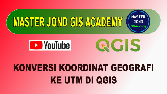
Jangan Salah! Begini Cara Konversi SHP ke UTM di QGIS 3 dengan Benar.
Konversi koordinat bisa bikin pusing kalau salah langkah! Simak tutorial ini untuk mengetahui cara yang benar mengubah SHP Geographic ke UTM di QGIS 3.
#GIS#QGIS#QGIS3#KonversiKoordinat#PetaDigital#SHPtoUTM#ProyeksiPeta#UTM#GeographicToUTM#SistemKoordinat#TutorialGIS#PanduanQGIS#BelajarGIS#Geospasial#DataSpasial#AnalisisGIS#AkurasiPeta#TransformasiKoordinat#PemrosesanData#GISMapping#ConvertSHPtoUTM#GISIndonesia#GeospatialTech#MappingSolution#DataGeospasial
0 notes
Text
Rahasia Konversi SHP Geographic ke UTM di QGIS 3 – Dijamin Mudah!
Masih bingung cara konversi SHP Geographic ke UTM di QGIS 3? Jangan khawatir! Ikuti panduan ini dan temukan cara termudah & tercepat untuk mendapatkan hasil akurat!
youtube
#GIS#QGIS#QGIS3#KonversiKoordinat#PetaDigital#SHPtoUTM#ProyeksiPeta#UTM#GeographicToUTM#SistemKoordinat#TutorialGIS#PanduanQGIS#BelajarGIS#Geospasial#DataSpasial#AnalisisGIS#AkurasiPeta#TransformasiKoordinat#PemrosesanData#GISMapping#ConvertSHPtoUTM#GISIndonesia#GeospatialTech#MappingSolution#DataGeospasial#Youtube
0 notes
Text
Exploring the Power of Lidar Technology: Transforming Surveys and Mapping Solutions

In today’s fast-evolving world, lidar technology has emerged as one of the most groundbreaking tools for precise surveying services. Whether it's for aerial surveys, topographic surveys, or advanced mapping solutions, lidar offers exceptional accuracy and efficiency. Let’s explore how this cutting-edge technology is reshaping industries and driving innovation.
What is Lidar Technology?
Lidar technology stands for Light Detection and Ranging. It uses laser pulses to measure distances and create highly accurate 3D models of terrain, structures, and vegetation. When combined with remote sensing, lidar helps gather geospatial data quickly and safely, making it indispensable for various industries such as urban planning, environmental monitoring, and infrastructure development.
The Role of Aerial Surveys in Modern Mapping Solutions
Aerial surveys powered by lidar technology are one of the most effective ways to collect data over large areas. Drones and aircraft equipped with lidar sensors capture high-resolution data of landscapes, buildings, and other features in real-time. These surveys play a vital role in mapping solutions for everything from land development projects to flood risk assessment.
Unlike traditional methods that require time-consuming fieldwork, lidar offers a much faster, safer, and more accurate alternative. With lidar technology, businesses and governments can make more informed decisions while saving time and money.
Why Remote Sensing and Geospatial Data Matter
Remote sensing through lidar provides a unique advantage in collecting geospatial data from areas that are difficult to access or hazardous. Whether it’s mapping forests, assessing flood zones, or surveying coastal regions, lidar can capture highly detailed information with precision.
This data is used to create topographic surveys that show the elevation and contours of the land, making it invaluable for urban planning, construction, and environmental studies. By having access to detailed, accurate data, professionals can plan projects more effectively, manage natural resources, and predict potential issues before they arise.
Innovation in Aviation: How Lidar Is Changing the Game
In the world of innovation in aviation, lidar technology has brought about a transformation. Drones equipped with lidar sensors are now being used for everything from forest inventory management to land surveying. These aircraft can fly over difficult terrain, gathering data without putting human surveyors at risk.
This technological advancement in aerial surveys is particularly valuable in India, where vast areas of land need to be mapped for development and environmental monitoring. By leveraging drones with lidar sensors, businesses and governments can gather high-quality data in a fraction of the time it would take using traditional methods.
The Future of Lidar Technology
As the demand for accurate geospatial data continues to rise, the future of lidar technology looks promising. The integration of remote sensing and lidar will only continue to grow, opening up new possibilities for surveying services and mapping solutions.
Whether you’re involved in urban planning, environmental conservation, or infrastructure development, lidar technology provides the tools necessary for smarter decision-making and more efficient planning.
Conclusion
The impact of lidar technology on industries worldwide cannot be overstated. From topographic surveys to aerial surveys, lidar is revolutionizing the way we collect, analyze, and visualize data. As it continues to evolve, this technology will undoubtedly play a pivotal role in shaping the future of mapping and surveying.
If you’re looking for a reliable lidar survey company to help with your next project, Atom Aviation offers cutting-edge surveying services with expertise in lidar technology. Whether for land development, environmental monitoring, or infrastructure planning, we have the solutions you need.
#LidarTechnology#AerialSurveys#MappingSolutions#GeospatialData#RemoteSensing#SurveyingServices#InnovationInAviation#TopographicSurveys
1 note
·
View note