#geodata
Text
GIS Services in Canada
GIS services are crucial for RS Solar CAD Group's operations, aiding in site selection, solar panel placement, and infrastructure planning. Our offerings include spatial analysis, data visualization, and custom mapping solutions tailored to meet the unique needs of solar energy projects. With our expertise, RS Solar CAD Group can optimize their designs, minimize environmental impact, and maximize energy production efficiency.
Our Services include Solar Design Services | GIS | CAD/Drafting | BIM | Project management | Civil Engineering | MEP | Permit plan set
To know more contact us Email: [email protected]/ [email protected] or calling / Whatsapp at +919958060424
#gis#geospatial#mapping#geography#cartography#geodata#spatialanalysis#geoinformatics#geospatialintelligence#geospatialtechnology#permit#proposals#engineeringstamp#solar#solarenergy#solarpower#solarinstallation#usa#usajobs#california#washington#oregon#nevada#idaho#montana#arizona#utah#colorado#newmexico#texas
0 notes
Text
I will do 5000 google map citation for local business SEO gmb ranking

#CitationManagement#OnlineMapping#NavigationalAid#GeoData#MapRanking#LocationIntelligence#VirtualMapping#MapLocalization#StreetViewCitation#GPSMapping#MapDiscovery
0 notes
Photo
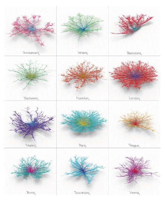
Follow @urbandesign.lab Coral Cities | An Ito Design Lab Concept "For the past six months I have been fascinated by the concept of making city networks look like living corals. The varying patterns of urban forms are inherently dictated by their road network; a complex, seemingly organic connection of links moving people across their city. Like branches of coral they have a pattern and a function, I chose to expose this pattern and manipulate it to become something far more conceptual. Read Less." Project by: @mapzilla_art (Craig Taylor) DM for credits/Removal. . . . . Photoshop Masterclass (2 Days Integrated Workshop) Session Details: • Day 1: 18th of February, 2023 | Urban Mapping • Day 2: 19th of February, 2023 | 3D Urban Visualization 🔗Registration link in the bio Limited Seats available! Early Bird registration ends on 12th February, 2023 . . . . #mapping #urbanplanning #GISmapping #urbandesign #nollimaps #citymapping #geospatial #geography #cartography #spatialdata #cityplanning #dataanalysis #sustainability #landscapearchitecture #smartcities #placemaking #geodata #opendata #mapmaking #urbanism #geospatialanalysis #urbanrenewal #3Dmapping #wayfinding #environmentaldesign #mobility #transportationplanning #urbanregeneration #publicspace #urbandesignlab (at United States) https://www.instagram.com/p/CorxtBRvDuB/?igshid=NGJjMDIxMWI=
#mapping#urbanplanning#gismapping#urbandesign#nollimaps#citymapping#geospatial#geography#cartography#spatialdata#cityplanning#dataanalysis#sustainability#landscapearchitecture#smartcities#placemaking#geodata#opendata#mapmaking#urbanism#geospatialanalysis#urbanrenewal#3dmapping#wayfinding#environmentaldesign#mobility#transportationplanning#urbanregeneration#publicspace#urbandesignlab
0 notes
Link
0 notes
Photo
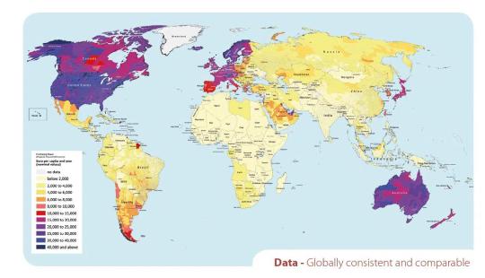
Purchasing Power (Disposal Household Income) Euro per capita and year (nominal values) by MB-International Worldwide Geodata
73 notes
·
View notes
Text
there should be some kind of app that lets you make your own maps of places. and i don't mean it just takes like existing geodata and lets you draw over it or whatever i mean you get to place down the roads and buildings and shit yourself
15 notes
·
View notes
Text
My study & organization apps as college student
First of all, is important to say that I’m 4th year Geography student and I use my cellphone (iPhone SE 2022) and a tablet (Samsung tab S7). Some apps are available just for one system, some are available for both. Biased that, some apps make sense for a GEOGRAPHY student, but may not be that helpful for other courses.
Notion
This one is a classic by now, right? I think I don’t have a lot to say about it, seems a little like a bullet journal but virtually, were you can creat a lot of pages and centrals. I use as a bullet journal + agenda + diary + note taking app!
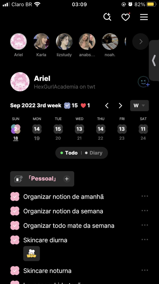
Todomate
So, I discovered this app on Twitter and i’m IN LOVE with this! It’s like a social network, but where you can do to-do lists! As I said, it’s a social network, so you can add your friends and see their own to-do lists! You can also interact with them, liking their daily feelings and their tasks. It’s really fun and easy to use! You can also create private lists, routines etc. Love it! (That’s my count in the print, btw. You can add me there if you want to: HexGurlAcademia! My todo lists are all in portuguese? Yes, but…)
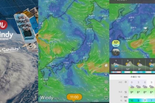
Windy
The must have to geoscience students! It’s an app that shows you a lot of geodata! Really good to check when there’s a storm coming or any climate event.
Noteshelf
Usually people use OneNote to do class notes, BUT it’s not available to android 🫠 but I founded this one! You can create groups, notebooks, transfer pdfs… I love to use this to read papers and texts for classes.
Samsung Notes
Another alternative to android users who wants to have a virtual notebook. You can also use the app in your PC!

Discord
So, did you know that there are a LOT of study communities on Discord? There are language learning communities, college servers (my university, for example, have one!), study buddies servers… I use to have study buddies and use pomodoro bots! There’s also a server I LOVE that has lo-fi rooms.
Classify
This one is a routine app! You can put not just your semester classes, but all your extracurricular activities! You can count study hours, add when your exams will be, homeworks… I really liked this one!
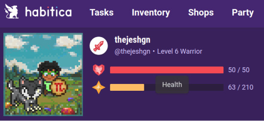
Habitica
Another routine app, but this one makes your tasks become a game! As more tasks you finish, you earn coins which you can exchange for things to up your character. You also earn xp to level up your character! I highly recommend it specially to teen/kid ADHD students! Trust me, it helps a lot transforming your life into a little game 😉
Yeolpumta (or YPT)
This one is a study chronometer! You can create your on profile, add friends, create and participate of study communities etc. I like this app, but may be discomfortable to people with anxiety, cuz you can see how many hours the others have been studying. If you study a lot of hours, your avatar changes and you go up in the groups and general rank. I stop using this so much cuz I was really anxious about it :/
Agenda Escolar
This one is a Brazilian app! Works very similar to Classify, but it’s a little simpler and 100% in brazilian portuguese.
Google stuff (Drive, Classroom etc)
Well, guess Skynet… I mean, Google, really dominate everything now… My college use Gmail to creat the institutional email for teachers and students, so EVERYTHING Google offers we use. Gmail, Drive, Google Docs, Google Sheets, Meets, Classroom… Not that happy about it, but yeah, I have no scape anyway lol
#pastel academia#dark academia#horror academia#app tips#study apps#dark academia apps#collegeblr#studyblr college#brazilian studyblr#studyblr#studyspo#geoblr#notion#todomate#ypt#yeolpumta#noteshelf#windy#samsung notes#discord#classify#habitica
149 notes
·
View notes
Text
I’m personally thrilled to say that, after being in progress for years, the Fionn Folklore Database is now up and running and is now viewable at fionnfolklore.org.
Generally speaking, it’s very hard, when discussing the Fenian Cycle, to talk about the oral tradition, which is often understudied compared to the medieval material. Thanks to the hard work of the Harvard department, we now have an extensive list of folktales, collectors, and Fenian characters, neatly organized and sorted, with geodata placing each individual tale in its geographical context, in three different languages and including tales collected in Ireland, Scotland, England, the United States, and Nova Scotia.
If you have any interest in the Fenian material, I highly recommend it, and my thanks to the Harvard department for the enormous gift they’ve just given, not just to the field, but to anyone who wants to get into this.
#irish mythology#celtic mythology#The Fenian cycle#Fionn mac Cumhaill#finn mac cool#diarmuid ua duibhne
235 notes
·
View notes
Text
"have you ever gotten a text from a gi-"
"no"
*loads up the geodata of 7 species more on an excel spreadsheet*
13 notes
·
View notes
Note
From what I've heard about the privacy issues w the tumblr live thing, I would implore u to use a VPN for more than the geodata 😰 livestream from u would be great so I wouldn't dream to discourage u but I'm feeling a little 🔪🔪 toward the tumblr live setup
in all fairness i think i posted my whole address on here once so i'm not too worried but good to know
13 notes
·
View notes
Text
Anyone in here smoke geodata?
I wish to make my own world map for my kitchen. Problem: I’m not at all versed in geography. Problem 2: I’ve recently seen the Waterman Butterfly, and now that’s what I want*.
This seems to not really be a ‘serious’ projection though, so I can’t just load it up in QGIS. Instead, I’ve been looking at geopandas and cartopy, but, like I said, Waterman is not really taken seriously, so proj (which is what cartopy uses under the hood) doesn’t have it either.
I have found D3, which does support it (and seems to allow defining your own much more easily too), but I don’t speak js, and I would prefer not to learn a new language from scratch. I’m not really seeing a way to define my own projection in cartopy/proj though.
I guess what I’m asking is, am I overlooking something? Or do I have to learn js anyway?
* (colored in with Köppen climate and height [oceans colored by depth], and overlaid with borders, country names and rivers, but that’s not where I’m at yet.)
2 notes
·
View notes
Note
do you agree mostly with the not just bikes channel or hes kinda biased.. and sound too bitter
I am fundamentally a very biased and bitter person myself so if he is, it goes under my radar. Have you ever lived in or visited Houston? It'll radicalize you. Slip lanes cutting through pedestrian crosswalks. Bike lanes that cross highway exit ramps. In the US location-specific crash and fatality geodata isnt available to the public but if you work in urban planning or civil engineering or with city government often times you have access to accurate GIS crash maps and you can see the deadliest intersections and the numbers are harrowing. Imo they dont keep these public because in the past crash survivors would find out that some of these road designs kill a dozen or more people a year and sue. Send me another ask with your thoughts about his bias please, id love to hear them!
3 notes
·
View notes
Text
go into ceLtic stUdiEs, they said! iT’ll bE FUN, they saiD!


[image ID: a screenshot of the columbia university library database and catalogue search engine “CLIO,” with “tochmarc treblainne” in the search bar. there are no results in any of the fields: catalog, geodata, articles+, academic commons, or libraries website]
[image ID: a screenshot of a line from an email reading: “No, you are on the right track. My PhD supervisor, William Gillies, once said that other fields have roads, police officers, buildings, etc where Celtic Studies is more like a field with a few meandering paths.]
#gradblr#celtic studies#just feeling EXTREMELY FRUSTRATED folks sorry#fun to write about primary sources that other academics have written on about three times total#thesis is going well as you can see
5 notes
·
View notes
Text
Navigating the World of Free CAD Downloads
Navigating the World of Free CAD Downloads
Computer-Aided Design (CAD) software has revolutionized the world of design and engineering. Whether you’re a professional engineer, a hobbyist, or a student, there’s a CAD software out there for you. The best part? Many of them are free. Here are some of the best free CAD software available for download:To get more news about cad download free, you can visit gstarcad.net official website.
1. FreeCAD12
FreeCAD is an open-source parametric 3D modeler made primarily to design real-life objects of any size. It allows you to easily modify your design by going back into your model history and changing its parameters. FreeCAD equips you with all the right tools for your needs, including modern Finite Element Analysis (FEA) tools, experimental CFD, dedicated BIM, Geodata, or CAM/CNC workbenches, and a robot simulation module.
2. AutoCAD LT3
AutoCAD LT is a commercial CAD software that offers a free version. It is best for Mac & Windows users and is known for its robust set of design and drafting tools. It’s ideal for professional use in architectural, engineering, and construction fields.
3. Planner 5D3
Planner 5D is a free 3D floor plan software for beginners. It has a simple yet intuitive interface and offers a wide range of ready-to-use floor plan templates. You can draw free floor plans in 2D and arrange a variety of items using a simple drag-and-drop function.
4. Floor Planner
Floor Planner is a free CAD software for floor plans. It offers an unlimited free floor planning tool and an intuitive interface. You can easily export 3D models and there are over 150,000 items to use in your plans.
5. GrabCAD
The GrabCAD Library offers millions of free CAD designs, CAD files, and 3D models. It’s a great resource for anyone looking to download free CAD files.
6. FreeCADS5
FreeCADS is a website where you can find thousands of CADs and vectors, all free to download. Whether you’re an architect or an engineer, a designer or a refiner, you’ll find a huge library of free CAD blocks and free vector art.
In conclusion, these free CAD software offer a wide range of features that can help you design your projects. They are user-friendly and offer a variety of tools and templates to help you get started. So why wait? Start designing your projects today!
0 notes
Text
Fully Funded PhD Position in Forest Science; Augmented Reality in Forestry at University Freiburg in Germany

Fully Funded PhD Position in Forest Science; Augmented Reality in Forestry at University Freiburg in Germany
Description: The chair of Forest Operations is seeking (Doctoral) Researcher for augmented reality in forestry for the project: Potential and feasibility study for the operational use of augmented reality augmented reality glasses in forestry (ForestAR). The project aims to evaluate the potential of augmented reality glasses (e.g. HoloLens 2) for forestry, to analyse the accuracy and reliability of the technology under different weather conditions and to investigate their acceptance in the forest sector. Innovative AR approaches, supported by AI, will be designed and AR application for geodata will be developed, tested and the efficiency of AR use will be determined through
Read the full article
0 notes
Last Seen Blogs

spectat-or
Espectador

poweredbygoldsrc
Self Proclaimed Ceo of Venturiantale Dark Pit

medivinegoddess
I Am Divine Goddess

clionoir
Ed

koalasoap-blog
Koala Soap Co.