#Papahānaumokuākea
Text
BREAKING NEWS:
NOAA proposes national marine sanctuary in Papahānaumokuākea

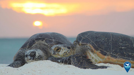
Today, NOAA has released a draft proposal to designate a national marine sanctuary in the marine portions of Papahānaumokuākea. Home to the endangered Hawaiian monk seal, threatened green turtles and many species found nowhere else on earth, the complex and highly productive marine ecosystems of Papahānaumokuākea are significant contributors to the biological diversity of the ocean.


Papahānaumokuākea is of great importance to Native Hawaiians, and Hawaiian culture is a foundational element in its management. It is also home to a variety of post-Western-contact historic resources, such as 19th-century commercial whaling shipwrecks and artifacts and those associated with World War II’s Battle of Midway.


The public is invited to comment on the sanctuary draft proposal through May 7, 2024.
254 notes
·
View notes
Text
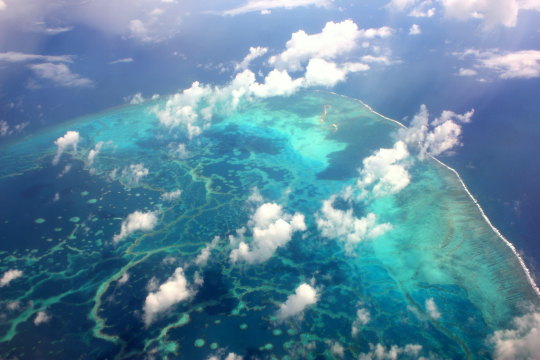
Papahānaumokuākea Marine National Monument is the largest contiguous fully protected conservation area under the U.S. flag, and one of the largest marine conservation areas in the world. It encompasses 582,578 square miles of the Pacific Ocean (1,508,870 square kilometers) - an area larger than all the country's national parks combined.
Papahānaumokuākea Marine National Monument
#quote#Papahānaumokuākea#Hawaii#Papahānaumokuākea Marine National Monument#nature#conservation#ecology#marine#marine conservation#oceans#Pacific Ocean
7 notes
·
View notes
Link
3 notes
·
View notes
Text
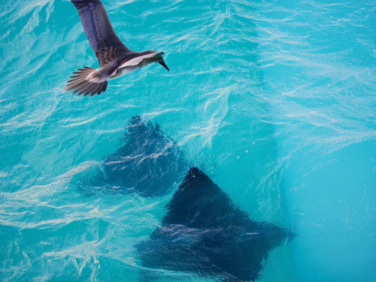
Bird and manta rays at Papahānaumokuākea Marine National Monument in Hawai'i. Photo by Kapulei Flores.
41 notes
·
View notes
Text
by Lucy Sherriff
The Guardian
May 18, 2023
Viewed by the Chumash people as their ancestral home, the Native American tribe is behind the first Indigenous-led initiative to protect the ocean and repair its damaged ecosystem
[....]
If successful, it would be the first tribally nominated, tribally led sanctuary on the US mainland. The proposed site will be a co-management initiative between the Chumash, other local tribal groups and the National Oceanic and Atmospheric Administration(Noaa). Noaa manages 14 national marine sanctuaries – as well as the Papahānaumokuākea and Rose Atoll marine national monuments – but this would be the first in partnership with an Indigenous group.
The sanctuary would stretch from near the coastal village of Cambria, halfway between San Francisco and Los Angeles, to just south of Santa Barbara County, encompassing 7,670 sq miles of ocean.
Read more.
#california#indigenous peoples#chumash#marine sanctuary#conservation#ecosystem conservation#environment
68 notes
·
View notes
Photo


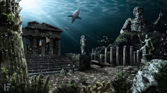

Have Researchers Found an Undersea Road to The Lost City of Atlantis?
Not every road leads to Rome.
Some paths appear to be headed to the center of the ocean — like one recently spotted by scientists in the Pacific that they dubbed the “road to Atlantis.”
Late last month, oceanographers aboard the EV Nautilus vessel were out exploring the floor of the Papahānaumokuākea Marine National Monument, a submarine range of volcanic mountains off the coast of Hawaii, when they came across what looked like a well-preserved brick road at the bottom of the sea.
On April 29, the researchers were amazed to see such a structure 3,376 feet underwater, near the top of Nootka Seamount. The discovery, as part of the Luʻuaeaahikiikekumu expedition, was captured on video during the group’s 24/7 livestream on YouTube.
“That’s a really unique structure,” another added.
“This is the yellow brick road,” a third researcher chimed.
“Are you kidding me? This is crazy,” an additional voice exclaimed.
Only about 3% of the 583,000 square miles within the Papahānaumokuākea Marine National Monument area has been recorded, although its peaks are known to rise over 16,000 feet from the seabed and summit just 200 feet below the surface of the water.
The legend of Atlantis dates back to Plato’s “Dialogues,” written about 360 B.C. — the first of all records of the lost city in history. In the philosopher’s tale, the city was a metaphor for the corruption of power, wealth and industry. In other words, it was created strictly as a plot device, and not the stuff of prehistoric folklore. Moreover, there isn’t a trace of archaeologic or geologic evidence that a sunken city ever existed.
Scholars are also quite sure that the realm of Oz existed only in the mind of “The Wonderful Wizard of Oz” author L. Frank Baum, who published the original story in 1900.
Researchers aboard the Nautilus had their fun when they dubbed the remarkable clip “Follow the ‘Yellow Brick Road’ to Geologic Features of Liliʻuokalani Ridge Seamounts” for social media, but explained the bricklike formation’s true nature in the caption.
“What may look like a ‘yellow brick road’ to the mythical city of Atlantis is really an example of ancient active volcanic geology,” they wrote.
What the team had actually seen was later identified as hyaloclastite, “a volcanic rock formed in high-energy eruptions where many rock fragments settle to the seabed,” they explained, while the “unique 90-degree fractures” that made it look like stone laid for a road are likely a result of “heating and cooling stress from multiple eruptions.”
The current mission, funded by the National Oceanic and Atmospheric Administration, set out for a deeper understanding of how the northwestern Hawaiian Islands were formed. They also hope to spot healthy communities of coral and sponge, which are under threat globally.
By Hannah Sparks.
#Have Researchers Found an Undersea Road to The Lost City of Atlantis?#road to atlantis#yellow brick road#oceanographers#archeology#archeolgst#geology#geologist#marine life#pacific ocean#mythical#mythical city#lost and found
37 notes
·
View notes
Text
Wir verbrachten unseren letzten vollen Tag auf Mauna Kea. Wir fuhren hoch zum Visitor Center auf 2.400m, der Leihwagen musste teilweise echt ein bisschen kämpfen, es ist gut dass es ein automatic war sonst hätte mich das ganze sehr viel mehr gestresst. Es war nicht wie das horror fahren in Costa Rica, in einem kleinen Manuelen Wägelchen mit weniger als 60 PS, aber schnell ging’s jetzt auch nicht. Aber wir haben es sicher und heile zum VIS geschafft und das Auto konnte ruhen.
Zu Beginn der Saddle Road aus Richtung Hilo war es total grau und verregnet und einfach schmuddel Hilo Wetter, und während wir uns dauernd auf einer schleichenden Steigung auf der Saddle Road befanden kam in der Ferne ein kleines blaues Loch auf uns zu in das wir immer weiter fuhren. Es wurde immer größer bis wir auf einmal unter blauem Himmel waren und zur Mauna Kea Access Road abbogen. Und ohne Wolken Mauna Kea hoch fruhren.
Oben angekommen, liefen wir oben links hinauf zum Sunset hill und haben die Aussicht genossen, die Höhe hat mir zu Beginn ein wenig ein Gleichgewichtsproblem gegeben, wie wenn ich nach dem tauchen zu schnell auftauche und der nicht so ganz richtig ist, wie leicht angetrunken. Hatte das Gefühl ich war dauernd auf einem slope der aber nicht da war. Aber das legte sich mit ein paar Minuten und dann war alles okay. Auf dem Sunset hill standen wir eine Weile rum, genossen die Aussicht zu Mauna Kea hoch und runter zu Mauna Loa. Von der Hilo Seite arbeiteten sich langsam Wolken hervor die immer mehr die Sicht auf Mauna Loa und das Tal zwischen den beiden abdeckte. Nora hatte etwas mit der Höhe zu kämpfen, ihr war etwas schlecht und ihre Lunge macht ihr momentan Probleme dass sie immer wieder Asthma und asthmatischen Husten bekommt. Somit hatte sie sich dann ein bisschen ins Auto gesetzt und ich mit einer super netten Rangerin geschnackt und sie gefragt was man auf der Höhe des VIS noch so machen kann. Sie sagte dann noch dass im Native Garden hinter den Picknick Bänken ein paar Silverswords wachsen, die just fyi 30 bis 40 Jahre brauchen bis sie mature werden und einmal blühen und dann sterben, aber hunderte Samen verteilen. Somit sind wir dann noch da lang getiegert und schon wieder runter gefahren. Auf dem Weg runter stoppten wir auf einem der kleineren Krater die wohl schon manchmal etwas belaufen wurden da es einen Trampelpfad gab. Als wir dann am Rand des Kraters standen und Richtung Mauna Loa / Hilo Sode schauten schlichen die Wolken immer mehr und mehr über den Krater Rand und wir konnten irgendwann nur noch in eine graue Wolkenwand schauen. Es war irgendwie ganz witzig da oben zu stehen und eigentlich mitten in der Wolke zu stehen und die Sonne auf einem zu spüren während diese feinen Wolken durch einen hindurch zogen und einem mit ganz feinen Nebel Tröpfchen befeuchteten.
Danach fuhren wir / Nora wieder zurück nach Hilo zu Safeway holten uns salt fürs Abendessen und dann war der Tag auch schon wieder vorbei.
Am letzten letzen Tag, an dem wir abends um 19 Uhr von Hilo nach HNL flogen schauten wir uns noch Rainbow Falls, die Boiling Pots und Pe‘epe‘e Falls vom Wailuku River an und liefen etwas durch Hiko Downtown. Dort ist auch ein kleines Museum über das Papahānaumokuākea Marine national Monument und man konnte über alle Hawaiianische Atolls, deren Fish, Vogel, invertebrate und pflanzen Fauna/Flora lesen und noch mal auf frischen wie die hawaiianischen Inseln geformt wurden (Hawaiian hot spot unter dem Ozean der immer wieder ausbricht und underwater Berge macht oder wenn es schnell genug geht, eine ganze Insel bildet die dann durch die tektonischen Platten Richtung Nordwesten geschoben werden). Da hätte ich wahrscheinlich Ewigkeiten verbringen können, war sehr sehr interessant Fisch und invertebrate Bilder zu sehen. Teilweise gibt es sehr schöne endemic angelfish species in den atolls.
Es gab ein frühes „Abendessen“ gegen 15 Uhr in einem veganen Vietnamesen und ich hatte zwei unterschiedliche Arten Reis mit Gemüse und Tofu, und ein spicy rotes curry mit Gemüse und Tofu bratlingen die echt lecker und simpel waren. Wie immer hatte ich Angst es würde mir nicht bekommen, aber es war soweit alles okay.
Derzeit sitzen wir a, Flughafen in Hilo und warten bis wir durch Security gehen um dann abzufliegen.
0 notes
Text
The Best U.S. National Monuments to Add to Your Bucket List — Daily Passport C
Similar to our national parks, national monuments protect and preserve historic sites and natural wonders from coast to coast, from New York’s Statue of Liberty to Hawaii’s Papahānaumokuākea marine area. Here are 16 of the best U.S. national monuments to visit.
— Read on dailypassport.com/best-us-national-monuments/
View On WordPress
0 notes
Text
ProtectTheOceans #BeneathTheSurfaceLiesTheFuture #ScienceRules
"Curious scientists use remotely operated vehicles to explore remote corners of the National Marine Sanctuary System. But sometimes, the animals are just as curious as we are – like when this #whiplashsquid investigated the NOAA Office of Ocean Exploration and Research vehicle in Papahānaumokuākea Marine National Monument!"
0 notes
Text


Wake up, it's Papahānaumokuākea Marine National Monument's birthday! 🎉
Papahānaumokuākea Marine National Monument is the single largest fully-protected conservation area in the world. It encompasses 582,578 square miles of the Pacific Ocean (1,508,870 square kilometers) – an area nearly the size of the Gulf of Mexico. The Monument, created expressly to protect an exceptional array of natural and cultural resources, was established by Presidential Proclamation 8031 on June 15, 2006 and expanded by Presidential Proclamation 9478 on August 26, 2016 under the authority of the Antiquities Act (16 U.S.C. 431-433). It is the United States' only mixed (natural and cultural) UNESCO World Heritage Site, recognized for both its cultural and natural significance.
#EarthIsBlue#Papahānaumokuākea#NOAA#Biodiversity#Conservation#Wahipana#WorldHeritageSite#Malama#UNESCOheritage#Ainamomona
124 notes
·
View notes
Text
Footage from deep in the Pacific Ocean has given the first detailed look at three World War II aircraft carriers that sank in the pivotal Battle of Midway and could help solve mysteries about the days-long barrage that marked a shift in control of the Pacific theater from Japanese to U.S. forces.Remote submersibles operating 3 miles (4.8 kilometers) below the surface conducted extensive archeological surveys in September of the Akagi and the Kaga, two of the four Imperial Japanese Navy aircraft carriers destroyed during the June 1942 battle, as well as the U.S.S. Yorktown.The high-quality video includes the official identification of the Akagi, while also providing new clues about the final hours of the aircraft carriers.The footage shows how the island, or the tall structure that rose above the Yorktown’s wooden deck, was damaged by extremely high heat and how the crew went to great lengths to keep the American ship from sinking.Julian Hodges, one of the last living veterans who served on the Yorktown, and who swam six hours with a dislocated shoulder to a rescue ship, teared up as he watched.“Boy, she took a beating,” Hodges said, just weeks shy of his 101st birthday. “I just hated to see my ship torn up like that.”All three aircraft carriers were found previously, the Yorktown in 1998 and the Japanese ships four years ago. The Akagi was only preliminarily identified, however, and limited images were recorded of the other two.That changed when Ocean Exploration Trust — founded by Bob Ballard, who led teams that discovered the Yorktown and the Titanic — conducted extensive video surveys of the three ships during a month-long exploration of the Papahānaumokuākea Marine National Monument in the Northwestern Hawaiian Islands, about 1,300 miles (2,092 kilometers) northwest of Honolulu.“We were able to spend over basically three full days on these sites, including two full days on the seafloor, really methodically and thoroughly documenting the entire wrecks,” Daniel Wagner, the chief scientist for Ocean Exploration Trust, told The Associated Press via videoconference from the exploration vessel Nautilus.The surveys were streamed online, allowing more than 100 scientists, historians and other experts from across the world to participate in a live forum alongside about two dozen scientists aboard the Nautilus.The Battle of Midway took place six months after the Japanese attacked Pearl Harbor on Dec. 7, 1941. The Japanese navy aimed to take control of the U.S. patrol plane base in a surprise attack at Midway Atoll, a tiny group of islands roughly halfway between the U.S. mainland and Asia. The country also wanted to destroy what was left of the U.S. Pacific Fleet.But U.S. forces intercepted communications about the attack and were ready.The five-day battle was fought about 200 miles (322 kilometers) off the group of islands. Besides sinking the Akagi, the Kaga and two other Japanese aircraft carriers, U.S. forces shot down more than 250 Japanese airplanes. More than 3,000 Japanese servicemen died.U.S. losses included more than 300 servicemen, about 150 airplanes and the Yorktown, which was damaged in the battle and then sunk by a Japanese submarine about 100 miles (161 kilometers) away while being towed for repairs.Of the 4,600 or so men who served on the Yorktown from 1937 to 1942, it’s believed there are only two still alive, said Michael Leggins, president of the U.S.S. Yorktown CV-5 Club, a group dedicated to providing information about the ship.One of them, Hodges, is a retired Baptist minister in Johnson City, Tennessee. He joined the Navy the day after Pearl Harbor and worked in the Yorktown’s boiler room during the battle.He recalled in a videoconference interview with the AP that after two torpedoes exploded, he found himself stuck between two pipes, his left arm so tightly pinned he couldn’t pull it out. His shoulder was also dislocated, an injury that still troubles him 81 years later.Once freed with the help of a fellow
sailor, a life jacket was taped over his injured shoulder and he held on to another to swim more than 3 miles (4.8 kilometers) to a waiting ship. He said the journey took about six hours.The other surviving Yorktown veteran, Robert Taylor, needed parental permission to join the Navy on Sept. 12, 1941, at the age of 17. Taylor, now 99, manned an anti-aircraft gun during the battle.Historians knew the crew tried to keep the ship afloat by jettisoning some smaller anti-aircraft guns on the port side. But among the discoveries from the new video was that the sailors also cut away the larger guns, said Hans Van Tilburg, the maritime archeologist and historian for the National Oceanic and Atmospheric Administration’s Office of National Marine Sanctuaries.The action “speaks to the dedication of the crew to save their vessel in the last and final moments of that ship’s service,” he said.When ordered to abandon ship, Taylor jumped overboard and tried to swim to a nearby destroyer, U.S.S. Balch, giving his life jacket to a fellow sailor who didn’t know how to swim.But as he neared the Balch, the ship started moving off to pick up more men in the water. A crewman on board tossed a line, which Taylor said he grabbed with his foot. He got alongside the destroyer and was pulled aboard but doesn’t remember much afterward.“They tell me I was screaming,” he told the AP from his home in Auburndale, Florida. The ordeal left him with post-traumatic stress disorder.The carriers will remain in their current location in U.S. protected waters, which should prevent them from being looted or becoming tourist destinations like the Titanic.The only things to be taken from the wrecks, Wagner said, will be the images and video they are sharing.Hodges said he appreciated that. “Nobody’s going to get anything out of it,” he said.He hopes the video spurs a new generation to consider the toll of conflict: “Whatever it takes to put wars out of business.”Taylor quipped that he would like the ship raised, if only to retrieve the $28 he left in his locker when the ship went down, about $530 in today’s money.Joking aside, the destruction of the Yorktown haunts him. “I was really upset because I loved that ship,” Taylor said. “It took a lot to sink it.”___Thiessen reported from Anchorage, Alaska.
0 notes
Text
Il raro polpo “Dumbo″ avvistato nelle acque profonde dell'Oceano Pacifico
A 1.682 metri di profondità, sotto il monumento marino che caratterizza il Parco Nazionale di Papahānaumokuākea, nelle Isole Hawaii nordoccidentali, la nave EV Nautilus ha ripreso il polpo che con le sue pinne svolazzanti ai lati della testa ricorda “Dumbo”, il celebre personaggio Disney. I ricercatori dell’Ocean Exploration Trust stavano esplorando il fondale oceanico quando nelle acque profonde…
View On WordPress
0 notes
Text

Juvenile brown noddy / noio kōhā (Anous stolidus) in Papahānaumokuākea Marine National Monument, Hawai'i. Photo by Kapulei Flores.
9 notes
·
View notes
Text
(video: bbc news | 23 sep 2023)
this footage is from EVNautilus live stream, which is exploring the Papahānaumokuākea Marine National Monument in the north Pacific Ocean.
The octopus can live at depths of up to 7,000 metres and has been filmed by a remotely-operated Ocean Exploration Trust vehicle.
0 notes
Text
Climate Links
Below are some relevant links related to biodiversity in the Hawaiian Islands. The main links I looked for were climate, geography, protected areas, wind patterns, and ocean currents. These are all the main factors influencing the climate and therefore the biodiversity of the Hawaiian Islands. Sources with scientific basis were desired over tourism-based blog references. In the protected areas, Kualoa Ranch and Hanauma Bay received their own links due to personal experience with them. Website landing pages were also favored, as they offer people the chance to pick which specific link they’d like to explore. Due to Hawaii’s location in the middle of the Pacific, numerous links on MMA (Marine Managed Areas) were included.
Climate
Climate of Hawaii Interactive Map
NOAA Climate of Hawaii Page
Rainfall Atlas of Hawaii
Evapotranspiration of Hawaii
Solar Radiation of Hawaii
Encyclopedia Britannica Climate of Hawaii
Hawaii: Climate Data.org
Geography
Hawaii: United States Geography
Maps of Hawaii
Islands and Cities
Rivers and Channels
Places and Landmarks
Satellite Map
Protected Areas
Papahānaumokuākea Marine National Monument
About MMAs Hawaii
Marine Managed Areas Interactive Map
Hawai’i Marine Life Conservation Areas
Marine Protected Areas in Hawaii PDF
Monuments and Sanctuaries: What's the Difference?
Hawai’i: Conservation.org
NPS Hawaii Park List
Hawaii Natural Area Reserve System
Hawai’i and Palmyra: The Nature Conservancy
Hawai’i Biodiversity: Natural Reserve Areas
Kualoa Ranch: Private Nature Preserve
Hanauma Bay State Park
Ocean/Wind Currents
Kuroshio Current
Current Forecast: Hawai’i
Little Islands Big Wake: NASA
How Currents Carry Marine Debris to the Hawaiian Islands
HAwaiian Coastal Waters Forecast
Pacific Weather Analysis
AccuWeather Hawaiian Wind Flow
Observation Summary From Hawaii
Hawaii Wind Maps
1 note
·
View note
Text
Faction Intro's: The Steel Legion
Ok, like I said before, I've already written short introductions to each of the factions so I might as well post them here, even though some of this has already been gone over.
Up first is the Steel Legion
The miners of the Papahānaumokuākea Asteroid Belt are much like the rocks they mine. Scattered, isolated, with tens of millions of miles between them. Oh, there’d always been a sort of loose belter culture since the early days of the system, but it was the kind of informal thing born of living in highly similar circumstances.
Loose trade agreements and occasional family ties were as close as it usually got, space was simply to big to care overmuch what some group a literal million kilometres away was doing.
At least, until an actually united polity started to encroach.
The République Universelle Raffiné (R.U.R, or République, to everyone else) is in many senses the opposite of the miners of the ‘Kea Belt. Where the miners were separated by extremes of distance, the République is one of the most densely packed populations in the entire system. Where the miners have a loose culture born of similar circumstances, the République is tight knit. Where the miners adopted cybernetic technology to directly benefit themselves, the République foisted the technical development off on their robots, to better provide for their civilization.
So when the République began moving into the belt as an organized, united force, there was really no body to do anything about it, or even really notice it at first. It wasn’t a big deal, just another player among thousands, with millions upon millions of rocks to go around. Then, to slowly for anyone not looking for the signs specifically to notice, the cascade began.
The République wasn’t just mining one rock until it was exhausted and then moving on. They spread out, enforced zones of control, restricted passage through ‘their’ territory, still, this wasn’t a big deal at first. Miner stations are built to eventually move, and so move they did, why kill people over some rocks? Only, stations don’t often move at one time, or in the same direction, and with the very informal ties between them any kind of coordination to prevent competing claims tension began to rise.
Years pass, the République expands, more miners move, some come to blows with other stations, unable or unwilling to work out a share, some try to push back against the République directly, and find out that a solitary mining station against a organized City-State doesn’t amount to much. Years pass, then a decade, then two, the cascade grows.
And nothing can grow forever.
Eventually, people caught on to how untenable the whole situation was. Either they let the R.U.R. continue to gobble up territory and just accept that infighting and violence between independent stations will become a fact of life, or they could organize. The first meeting was recorded as having representatives from 47 different stations, the most notable among them being: Jayashri Magro from Liere, the most technically advanced station at the meetings, Algernon Higashi from Karumel, who’s leaders had already begun building small alliances, Mwenya Svoboda from Kailash, who claimed to have seen this coming from the beginning, and Kelvin Stanev from Olympos, the largest single station in the belt.
A unified front would allow them to confront the République, work something out from a better position than just a handful of easily pushed around Belter’s. It still wasn’t easy, internal negotiations were actually harder then bringing the R.U.R to the table, and the vast majority of belt stations wanted little to do with them, long used to their independence. Even with all that, the day arrived, despite somes misgivings, a conference on neutral ground, Telonokis Station.
How did things go so wrong?
0 notes
Last Seen Blogs


sargentleth6
The Journey of Franklin 593

charliesimss
Dime Family est. 2016


bestofalicia
Best of Alicia Vikander